
 Search
2018 Hurricane Season
Page 12 of 18 •  1 ... 7 ... 11, 12, 13 ... 18
 ![]()
Re: 2018 Hurricane Season
![]() by nutleyblizzard Fri Sep 07, 2018 6:29 am
by nutleyblizzard Fri Sep 07, 2018 6:29 am
nutleyblizzard- Senior Enthusiast

- Posts : 1952
Join date : 2014-01-30
Re: 2018 Hurricane Season
![]() by jmanley32 Fri Sep 07, 2018 6:31 am
by jmanley32 Fri Sep 07, 2018 6:31 am
jmanley32- Senior Enthusiast
- Posts : 20512
Join date : 2013-12-12
Re: 2018 Hurricane Season
![]() by skinsfan1177 Fri Sep 07, 2018 6:53 am
by skinsfan1177 Fri Sep 07, 2018 6:53 am

skinsfan1177- Senior Enthusiast
- Posts : 4485
Reputation : 35
Join date : 2013-01-07
Age : 46
Location : Point Pleasant Boro
Re: 2018 Hurricane Season
![]() by nutleyblizzard Fri Sep 07, 2018 6:55 am
by nutleyblizzard Fri Sep 07, 2018 6:55 am
One run of many possible scenarios. As of this morning while still possible, I'm feeling more confident Florence will not go OTS. Like I mentioned last night, I'm concerned she remains just offshore and becomes a slow moving coastal hugger. With that kind of track the storm would maintain its strength much longer while going up the coastline. Its all dependent where and when that ridge builds when Florence approaches.jmanley32 wrote:7 to 10 inches rain hurricane force winds prolly cat 1 or strong ts for metro. Hey ill take a day off work lol schools would def be closed. But its just one run models are far from b done flip flopping I'm sure

nutleyblizzard- Senior Enthusiast
- Posts : 1952
Reputation : 41
Join date : 2014-01-30
Age : 57
Location : Nutley, new jersey
Re: 2018 Hurricane Season
![]() by sroc4 Fri Sep 07, 2018 7:03 am
by sroc4 Fri Sep 07, 2018 7:03 am

There are multiple factors here that will be at play. For me some of the bigger items are becoming clear, ie: she is missing the first bus OTS, and the 500mb ridge will trap her and cont her path in a west to NW direction over the next few days; however, Florence's intensity in the next 3-5 days will become important. The reason being is that the influences of the steering layers of the atmosphere will change depending on her intensity. This means that even though the mean 500mb flow from such a strong ridge may be west NW, if Florence is a major hurricane then she will likely be influenced in her direction by some of the upper layers of the atmosphere as well. If the upper layers are in a different direction than the 500mb layer then her track will not be as simple as which direction is the ridge pushing her.
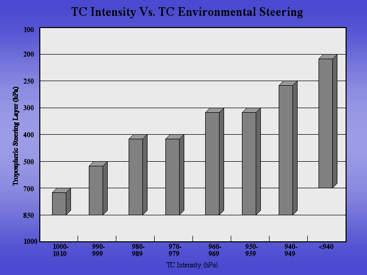
If she stays below a certain intensity then she will stay below the influences of certain layers of the atmosphere. If you are being pushed by one person in the back then you will move forward in the direction which the person is pushing you. However; if you are being pushed by 3 people all in slightly diff directions, all with slightly different forces, and all from slightly different heights on your body, then the direction for which you move ends up the sum of all the forces or vectors on your body; not just forward from the person pushing you in the back. Below is another simple example. In the below example pretend Flo is a major hurricane with a 930mb min central pressure. Flo is being acted upon by three diff forces; he 300mb has the strongest winds. Her direction will not simply be in the same direction the 500mb flow is pushing her even though the ridge is strong. Her movment is now influenced by other steering layers because of how strong her vortex is.

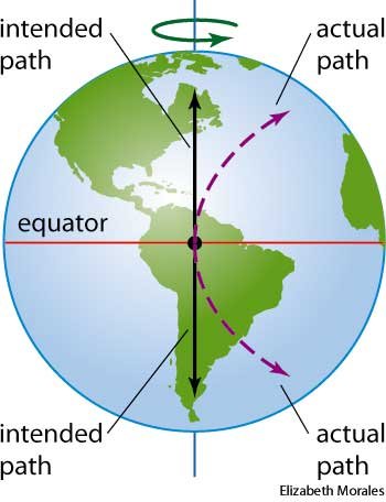
Combine this along with the natural Coriolis effect (an effect whereby a mass moving in a rotating system experiences a force (the Coriolis force ) acting perpendicular to the direction of motion and to the axis of rotation. On the earth, the effect tends to deflect moving objects to the right in the northern hemisphere ). NOTE: the further north away from the equator a system gets the more the Coriolis effect influences a system. This is why it is so hard to get a Trop system NOT to recurve at such high latitudes.
So keep this info in the back of your minds when looking at the models come in over the next several days. As she gains latitude and strength the tendency will be to turn right. What forces at the various layers of the atmosphere are acting upon her to prevent that from happening and cont to steer her more westerly towards the coast? Will it be enough to prevent her from recurving? These are things we just don't know yet.
WE TRACK!!!!

Last edited by sroc4 on Fri Sep 07, 2018 7:14 am; edited 1 time in total
_________________
"In weather and in life, there's no winning and losing; there's only winning and learning."
WINTER 2012/2013 TOTALS 43.65"WINTER 2017/2018 TOTALS 62.85" WINTER 2022/2023 TOTALS 4.9"
WINTER 2013/2014 TOTALS 64.85"WINTER 2018/2019 TOTALS 14.25" WINTER 2023/2024 TOTALS 13.1"
WINTER 2014/2015 TOTALS 71.20"WINTER 2019/2020 TOTALS 6.35"
WINTER 2015/2016 TOTALS 35.00"WINTER 2020/2021 TOTALS 37.75"
WINTER 2016/2017 TOTALS 42.25"WINTER 2021/2022 TOTALS 31.65"

sroc4- Admin

- Posts : 8331
Reputation : 301
Join date : 2013-01-07
Location : Wading River, LI
Re: 2018 Hurricane Season
![]() by jmanley32 Fri Sep 07, 2018 7:09 am
by jmanley32 Fri Sep 07, 2018 7:09 am

jmanley32- Senior Enthusiast
- Posts : 20512
Reputation : 108
Join date : 2013-12-12
Age : 42
Location : Yonkers, NY
Re: 2018 Hurricane Season
![]() by sroc4 Fri Sep 07, 2018 7:18 am
by sroc4 Fri Sep 07, 2018 7:18 am
_________________
"In weather and in life, there's no winning and losing; there's only winning and learning."
WINTER 2012/2013 TOTALS 43.65"WINTER 2017/2018 TOTALS 62.85" WINTER 2022/2023 TOTALS 4.9"
WINTER 2013/2014 TOTALS 64.85"WINTER 2018/2019 TOTALS 14.25" WINTER 2023/2024 TOTALS 13.1"
WINTER 2014/2015 TOTALS 71.20"WINTER 2019/2020 TOTALS 6.35"
WINTER 2015/2016 TOTALS 35.00"WINTER 2020/2021 TOTALS 37.75"
WINTER 2016/2017 TOTALS 42.25"WINTER 2021/2022 TOTALS 31.65"
sroc4- Admin
- Posts : 8331
Reputation : 301
Join date : 2013-01-07
Location : Wading River, LI
Re: 2018 Hurricane Season
![]() by amugs Fri Sep 07, 2018 9:57 am
by amugs Fri Sep 07, 2018 9:57 am
If there is a correction, it will be slightly to the southwest rather than northeast. SST's are record warm, and this has aided the positive feedback loop whereby mid level ridges are invariably undermodeled. Short wave troughs have consistently weakened upon approach toward the NWATL this summer. The GFS has a bias for eroding ATL ridges too rapidly. Conversely, the UK has a notorious southern bias. The most likely track will be a hit somewhere between Wilmington NC and the NJ coast, within which, OBX may be the center point of initial landfall. Thereupon, details become indeterminate. Those are my perfunctory thoughts right now, given rather limited time to analyze the data, but these are strong impressions I've gleaned.
_________________
Mugs
AKA:King: Snow Weenie
Self Proclaimed
WINTER 2014-15 : 55.12" +.02 for 6 coatings (avg. 35")
WINTER 2015-16 Total - 29.8" (Avg 35")
WINTER 2016-17 : 39.5" so far

amugs- Advanced Forecaster - Mod

- Posts : 15091
Reputation : 213
Join date : 2013-01-07
Age : 54
Location : Hillsdale,NJ
Re: 2018 Hurricane Season
![]() by jmanley32 Fri Sep 07, 2018 7:27 pm
by jmanley32 Fri Sep 07, 2018 7:27 pm
jmanley32- Senior Enthusiast
- Posts : 20512
Reputation : 108
Join date : 2013-12-12
Age : 42
Location : Yonkers, NY
Re: 2018 Hurricane Season
![]() by weatherwatchermom Sat Sep 08, 2018 11:24 am
by weatherwatchermom Sat Sep 08, 2018 11:24 am
we now have Tropical Storm Helene!

weatherwatchermom- Senior Enthusiast
- Posts : 3729
Reputation : 77
Join date : 2014-11-25
Age : 60
Location : Hazlet Township, NJ
Re: 2018 Hurricane Season
![]() by amugs Mon Sep 10, 2018 10:14 pm
by amugs Mon Sep 10, 2018 10:14 pm

_________________
Mugs
AKA:King: Snow Weenie
Self Proclaimed
WINTER 2014-15 : 55.12" +.02 for 6 coatings (avg. 35")
WINTER 2015-16 Total - 29.8" (Avg 35")
WINTER 2016-17 : 39.5" so far
amugs- Advanced Forecaster - Mod
- Posts : 15091
Reputation : 213
Join date : 2013-01-07
Age : 54
Location : Hillsdale,NJ
Re: 2018 Hurricane Season
![]() by Frank_Wx Tue Sep 11, 2018 7:25 am
by Frank_Wx Tue Sep 11, 2018 7:25 am
Helene gets engulfed into an upper level low. She will remain well out to sea.
Argh!!!
_________________
_______________________________________________________________________________________________________
CLICK HERE to view NJ Strong Snowstorm Classifications

Frank_Wx- Godzilla Seeker
- Posts : 21305
Reputation : 328
Join date : 2013-01-05
Age : 31
Location : Jersey City, NJ -

Re: 2018 Hurricane Season
![]() by jmanley32 Tue Sep 11, 2018 5:32 pm
by jmanley32 Tue Sep 11, 2018 5:32 pm
Last edited by jmanley32 on Tue Sep 11, 2018 8:36 pm; edited 1 time in total
jmanley32- Senior Enthusiast
- Posts : 20512
Reputation : 108
Join date : 2013-12-12
Age : 42
Location : Yonkers, NY
Re: 2018 Hurricane Season
![]() by Quietace Tue Sep 11, 2018 6:25 pm
by Quietace Tue Sep 11, 2018 6:25 pm
Be careful with Issac, it could hold together long enough to interact with Florence. Will have to keep an eye on it.Frank_Wx wrote:Issac is going to battle wind shear. Looks like he will die out.
Helene gets engulfed into an upper level low. She will remain well out to sea.
Argh!!!

Quietace- Meteorologist - Mod

- Posts : 3687
Reputation : 33
Join date : 2013-01-07
Age : 27
Location : Point Pleasant, NJ
Re: 2018 Hurricane Season
![]() by jmanley32 Wed Sep 12, 2018 12:58 pm
by jmanley32 Wed Sep 12, 2018 12:58 pm
jmanley32- Senior Enthusiast
- Posts : 20512
Reputation : 108
Join date : 2013-12-12
Age : 42
Location : Yonkers, NY
Re: 2018 Hurricane Season
![]() by jmanley32 Wed Sep 12, 2018 1:00 pm
by jmanley32 Wed Sep 12, 2018 1:00 pm
jmanley32- Senior Enthusiast
- Posts : 20512
Reputation : 108
Join date : 2013-12-12
Age : 42
Location : Yonkers, NY
Re: 2018 Hurricane Season
![]() by sroc4 Fri Sep 14, 2018 7:50 am
by sroc4 Fri Sep 14, 2018 7:50 am
sroc4 wrote:A huge shift is occurring in the large scale global wind pattern forecast. Below I am posting the 200 Hpa or 200mb (Approx 32,000ft above sea level), wind patterns. When air at the surface converges it can't go down through the ground so is forced to rise giving way to low pressure. However; in the upper levels the opposite is true. The orange colors depict air that is converging(coming together at a center point); whereas the green colors depict air that is diverging(moving away from a center point). At this altitude picture on a large scale winds coming together horizontally, convergence, over areas in orange. When the air from the west meets the air from the east it crashes into each other and the air molecules are forced downward, so sinking air or subsidence. Flip the coin...picture the air at 32k ft moving away from a center point, divergence. In order to replace the air molecules spreading apart horizontally, air beneath it is forced to rise up to replace it, convection.
First image is week 1 forecast, Aug 27th -Sept 3rd. Second image is week 2, Sept3rd-- Sept 11th. Notice the big picure pattern in week one is to have the convergence zone over the Trop pacific and the divergent zone over the Trop Atlantic. However in week two that appears to be shifting. Look just how strong the areas of orange are over the Western Pac and the greens become over the eastern Pac and Atlantic. This means that lower pressures will be favored in areas of green.
More simply stated if there are tropical waves traversing the lower levels of the atmosphere beneath the areas in green the upper levels will be more conducive for trop development. Trop waves up through this point and through week one forecast have traversed under the areas of orange meaning that the air above them has been sinking; which is NOT favorable for trop development. What this means is that the Atlantic is coming to life folks if this forecast is true. Now just because the upper levels are becoming more favorable this doesn't mean a guarantee for development, but its a start. The Eastern Pac seems to show the strongest areas of upper level divergence so it may steal the thunder for development. But given this upper level pattern the modeling, as its just starting to do, will def start producing trop systems in the long range. Keep this in mind. I posted these maps a few days ago and the forecast was drastically different. This is because the MJO forecast was drastically different a few days ago. I also pointed out in my discussion a few days ago that the MJO forecast had been doing some weird things. Prev the forecast was to take the MJO wave out into phase 4-5 with at least some amplitude; however, the forecasted amplitude into these phases has trended weaker and weaker and now as you can see the forecast now has it coming out in phase 8-1 and possibly never coming out of the null phase at all before doing so. This is drastically diffenet than just a few days ago where it still had the MJO coming out into phases 4/5. This is likely the big difference in the flipping of the 200mb forecast maps I posted above. We will have to see how this all plays out. I still think it takes a little longer than whatis modeled to really get things going. Ray(rb) stated first half of Sept and I stated second half. The way things look it appears that mid sept we will get a trop system to track towards the mainland which means we were both correct in the analysis, but we simply came at it from slightly diff angles.


2-3 week lead time. Ray if your reading pat on the back. Looks like your video and my response to your video on Aug 24th were spot on.
This was a conversation originally posted on August 31st where I posted the 200mb wind anomaly maps. Read above for a refresher on what they mean. Florence was first designated as a TD on August 31st as it exited the African coast. If you look on the images while most of the Atlantic was in orange(convergence aloft) the area just off the African coast was white or even slight green at the time the NHC designated what was to be Florence a TD. As you head out in time on the maps above it was Around Sept 4th that the Atlantic 200mb pattern flipped from one of convergence aloft(orange) to one that was divergent aloft(green). Again read above to see what that means for tropical development. This was about the time we saw the Atlantic explode with 3 named storms and at least 1-2 other areas designated for potential development. At the same time the MJO, instead of coming out in phases 4-5 remained in the null phases and weakly emerged out in phases 8-1. Meaning the rising and sinking motion configuration, walker cells, became favorable for Tropical development in the Atlantic and the forecast from 2 weeks out did not disappoint.
So why am I bringing this up? Well below now is the next week 1 and week 2 200mb forecast along with the MJO forecast. Notice week one the Atlantic goes back into the orange, but week two the Atlantic goes back into the green; esp the Caribbean, GOM and western Atlantic along the EC. Very similar to what we saw forecasted above from the last week in August. Also look at the MJO forecast. Emergence back into phases 8-1. What this is telling me is that our tropical season is not over. While we likely have a bit of a lull over the next week, I expect the tropics to come back to life again around aprox the 20-21st time frame and the potential exists for at least 1 tropical system affecting the US mainland somewhere between Sept 24th-Oct1st time frame. Also note what is currently TD Isaac in the Eastern Caribbean, if he doesn't get completely torn apart over the next 4-6days as he heads west conditions will likely become more favorable for re-development as it heads into the western Caribbean and or GOM.
Again LR forecasts are simply that...forecasts. They can change as we get in close, so thing is set in stone. So we will just have to watch.


_________________
"In weather and in life, there's no winning and losing; there's only winning and learning."
WINTER 2012/2013 TOTALS 43.65"WINTER 2017/2018 TOTALS 62.85" WINTER 2022/2023 TOTALS 4.9"
WINTER 2013/2014 TOTALS 64.85"WINTER 2018/2019 TOTALS 14.25" WINTER 2023/2024 TOTALS 13.1"
WINTER 2014/2015 TOTALS 71.20"WINTER 2019/2020 TOTALS 6.35"
WINTER 2015/2016 TOTALS 35.00"WINTER 2020/2021 TOTALS 37.75"
WINTER 2016/2017 TOTALS 42.25"WINTER 2021/2022 TOTALS 31.65"
sroc4- Admin
- Posts : 8331
Reputation : 301
Join date : 2013-01-07
Location : Wading River, LI
Re: 2018 Hurricane Season
![]() by Frank_Wx Fri Sep 14, 2018 8:56 am
by Frank_Wx Fri Sep 14, 2018 8:56 am


Shear also doesn't seem to be an issue.
_________________
_______________________________________________________________________________________________________
CLICK HERE to view NJ Strong Snowstorm Classifications
Frank_Wx- Godzilla Seeker
- Posts : 21305
Reputation : 328
Join date : 2013-01-05
Age : 31
Location : Jersey City, NJ -
Re: 2018 Hurricane Season
![]() by jmanley32 Sun Sep 16, 2018 2:04 pm
by jmanley32 Sun Sep 16, 2018 2:04 pm
jmanley32- Senior Enthusiast
- Posts : 20512
Reputation : 108
Join date : 2013-12-12
Age : 42
Location : Yonkers, NY
Re: 2018 Hurricane Season
![]() by sroc4 Mon Sep 17, 2018 8:03 am
by sroc4 Mon Sep 17, 2018 8:03 am
jmanley32 wrote:So do you guys think the season will pick up again or die down from here on?> I mean its only 5 days after the peak. But things are getting kinda quiet for now anyways. May have to watch Flo if she pulls that recurve back toward to US, but more likely is the exceleration back to N Atlantic. Still feel like we will see a real threat this year, just a hunch as I said before, but if not I cannot wait to track winter storms and noreasters. Shoot some of our 2018 noreasters had winds stronger than a TS.
Quote taken from above write up: While we likely have a bit of a lull over the next week, I expect the tropics to come back to life again around aprox. the 20-21st time frame and the potential exists for at least 1 tropical system affecting the US mainland somewhere between Sept 24th-Oct1st time frame.
Personally I think the threat to the US mainland extends at least through the 1st week of Oct as well. For now regarding the tropics some down time, but confidence is high that it gets active again in the time frame stated.
_________________
"In weather and in life, there's no winning and losing; there's only winning and learning."
WINTER 2012/2013 TOTALS 43.65"WINTER 2017/2018 TOTALS 62.85" WINTER 2022/2023 TOTALS 4.9"
WINTER 2013/2014 TOTALS 64.85"WINTER 2018/2019 TOTALS 14.25" WINTER 2023/2024 TOTALS 13.1"
WINTER 2014/2015 TOTALS 71.20"WINTER 2019/2020 TOTALS 6.35"
WINTER 2015/2016 TOTALS 35.00"WINTER 2020/2021 TOTALS 37.75"
WINTER 2016/2017 TOTALS 42.25"WINTER 2021/2022 TOTALS 31.65"
sroc4- Admin
- Posts : 8331
Reputation : 301
Join date : 2013-01-07
Location : Wading River, LI
Re: 2018 Hurricane Season
![]() by jmanley32 Mon Sep 17, 2018 12:49 pm
by jmanley32 Mon Sep 17, 2018 12:49 pm
sorry I missed that part. Mainland could b gom too and isn't that usually time the gom gets going? Of course sandy happened in late October so u really never know when or where these will pop up.sroc4 wrote:jmanley32 wrote:So do you guys think the season will pick up again or die down from here on?> I mean its only 5 days after the peak. But things are getting kinda quiet for now anyways. May have to watch Flo if she pulls that recurve back toward to US, but more likely is the exceleration back to N Atlantic. Still feel like we will see a real threat this year, just a hunch as I said before, but if not I cannot wait to track winter storms and noreasters. Shoot some of our 2018 noreasters had winds stronger than a TS.
Quote taken from above write up: While we likely have a bit of a lull over the next week, I expect the tropics to come back to life again around aprox. the 20-21st time frame and the potential exists for at least 1 tropical system affecting the US mainland somewhere between Sept 24th-Oct1st time frame.
Personally I think the threat to the US mainland extends at least through the 1st week of Oct as well. For now regarding the tropics some down time, but confidence is high that it gets active again in the time frame stated.
jmanley32- Senior Enthusiast
- Posts : 20512
Reputation : 108
Join date : 2013-12-12
Age : 42
Location : Yonkers, NY
Re: 2018 Hurricane Season
![]() by amugs Mon Sep 17, 2018 10:31 pm
by amugs Mon Sep 17, 2018 10:31 pm

_________________
Mugs
AKA:King: Snow Weenie
Self Proclaimed
WINTER 2014-15 : 55.12" +.02 for 6 coatings (avg. 35")
WINTER 2015-16 Total - 29.8" (Avg 35")
WINTER 2016-17 : 39.5" so far
amugs- Advanced Forecaster - Mod
- Posts : 15091
Reputation : 213
Join date : 2013-01-07
Age : 54
Location : Hillsdale,NJ
Re: 2018 Hurricane Season
![]() by jmanley32 Tue Sep 18, 2018 7:47 pm
by jmanley32 Tue Sep 18, 2018 7:47 pm
jmanley32- Senior Enthusiast
- Posts : 20512
Reputation : 108
Join date : 2013-12-12
Age : 42
Location : Yonkers, NY
Re: 2018 Hurricane Season
![]() by sroc4 Thu Sep 20, 2018 2:36 pm
by sroc4 Thu Sep 20, 2018 2:36 pm
jmanley32 wrote:sorry I missed that part. Mainland could b gom too and isn't that usually time the gom gets going? Of course sandy happened in late October so u really never know when or where these will pop up.sroc4 wrote:jmanley32 wrote:So do you guys think the season will pick up again or die down from here on?> I mean its only 5 days after the peak. But things are getting kinda quiet for now anyways. May have to watch Flo if she pulls that recurve back toward to US, but more likely is the exceleration back to N Atlantic. Still feel like we will see a real threat this year, just a hunch as I said before, but if not I cannot wait to track winter storms and noreasters. Shoot some of our 2018 noreasters had winds stronger than a TS.
Quote taken from above write up: While we likely have a bit of a lull over the next week, I expect the tropics to come back to life again around aprox. the 20-21st time frame and the potential exists for at least 1 tropical system affecting the US mainland somewhere between Sept 24th-Oct1st time frame.
Personally I think the threat to the US mainland extends at least through the 1st week of Oct as well. For now regarding the tropics some down time, but confidence is high that it gets active again in the time frame stated.
Right on cue.

_________________
"In weather and in life, there's no winning and losing; there's only winning and learning."
WINTER 2012/2013 TOTALS 43.65"WINTER 2017/2018 TOTALS 62.85" WINTER 2022/2023 TOTALS 4.9"
WINTER 2013/2014 TOTALS 64.85"WINTER 2018/2019 TOTALS 14.25" WINTER 2023/2024 TOTALS 13.1"
WINTER 2014/2015 TOTALS 71.20"WINTER 2019/2020 TOTALS 6.35"
WINTER 2015/2016 TOTALS 35.00"WINTER 2020/2021 TOTALS 37.75"
WINTER 2016/2017 TOTALS 42.25"WINTER 2021/2022 TOTALS 31.65"
sroc4- Admin
- Posts : 8331
Reputation : 301
Join date : 2013-01-07
Location : Wading River, LI
Re: 2018 Hurricane Season
![]() by jmanley32 Mon Sep 24, 2018 7:57 am
by jmanley32 Mon Sep 24, 2018 7:57 am
jmanley32- Senior Enthusiast
- Posts : 20512
Reputation : 108
Join date : 2013-12-12
Age : 42
Location : Yonkers, NY
Re: 2018 Hurricane Season
![]() by Quietace Mon Sep 24, 2018 8:16 am
by Quietace Mon Sep 24, 2018 8:16 am
Per CSU, 2018 (AVG through 09/24).jmanley32 wrote:So we can't get rid of Flo and she may even develop off se coast b4 getting swept put by the front wed. Leslie which according to gfs will meander in circles pretty healthy in central Atlantic. Tries to head west but doesn't look like that's possible. And short lived kirk. So what's that 12 storms? So we are above average and I think we see 2 -4 more named as October can be pretty active. Nothing of threat at this time unless Flo pulls a surprise.
-> Basin|Named Storms |Named S Days |Hurricanes |Hurricane Days| Major Hurricanes |Major Hurricane Days| ACE|
-> NA| 12 (8.5)| 56.00 (39)| 5 (4.2)| 16.00 (16.9)|1 (2.0)|3.75 (5.1)|82.6 (74)|
We will see where we end up. ACE is only slightly above average while the named storms are well. Luckily you can be ABV A with named storms but have below normal ACE due to these "crap" storms that last 1-2 days (Hence why ACE is a great metric for measuring activity).
Quietace- Meteorologist - Mod
- Posts : 3687
Reputation : 33
Join date : 2013-01-07
Age : 27
Location : Point Pleasant, NJ
Re: 2018 Hurricane Season
![]() by rb924119 Mon Sep 24, 2018 9:40 am
by rb924119 Mon Sep 24, 2018 9:40 am
rb924119- Meteorologist

- Posts : 6888
Reputation : 194
Join date : 2013-02-06
Age : 32
Location : Greentown, Pa
Page 12 of 18 • 1 ... 7 ... 11, 12, 13 ... 18 ![]()
|
|
|