Long Range Thread 18.0
+48
Roger92
Quietace
GreyBeard
mmanisca
oldtimer
Dunnzoo
Irish
snowday111
brownie
Grselig
Zhukov1945
Snow88
crippo84
bobjohnsonforthehall
Scullybutcher
dkodgis
Smitty623
snowlover 12345
heehaw453
dsix85
jimv45
Math23x7
sroc4
aiannone
Vinnydula
Sanchize06
SENJsnowman
emokid51783
HectorO
lglickman1
Carvin
nutleyblizzard
SoulSingMG
hyde345
docstox12
amugs
algae888
Radz
CPcantmeasuresnow
skinsfan1177
billg315
rb924119
weatherwatchermom
mwilli5783
jmanley32
adamfitz1969
frank 638
Frank_Wx
52 posters
Page 27 of 36
Page 27 of 36 •  1 ... 15 ... 26, 27, 28 ... 31 ... 36
 Re: Long Range Thread 18.0
I guess another way to put it is, my view is that in the short-term I like to look at the models for smaller scale details. But the further out you get from the current data input, the more small errors in the modeling can compound making the small-scale "details" less reliable. However the larger scale atmospheric patterns may still be somewhat accurately reflected so they can give you hints of what may happen.
billg315- Advanced Forecaster - Mod

- Posts : 4461
Join date : 2015-01-24
 Re: Long Range Thread 18.0
Where I live its an F. I currently have 10 inches for the season. I need another 20 just to make it to average. I'm going to need a big storm to make it happen. These minor events are not adding up enough.CPcantmeasuresnow wrote:jimv45 wrote:You took the words right out of my mouth Hyde!! It was some mirage with winter being over I guess I hurt my back with that ice this morning, and the storm before you had close to 8 inches and me around 5 . you can't say winter is over in these parts until April even though this winter has been a big let down.
I couldn't agree more with Hyde and Jim. Maybe some on the coastal plain are throwing in the towel but 25 miles N&W of NYC it can snow through mid April.
8.5 inches in January and 2.9 inches so far in February isn't great and the storms have been frustrating with all the mixing. The temperatures haven't been great either although January did end up normal temp wise. If we can get from Mid February through March to cooperate this winter could still get a C+ here, right now it's a D.
nutleyblizzard- Senior Enthusiast

- Posts : 1952
Join date : 2014-01-30
 Re: Long Range Thread 18.0
nutleyblizzard wrote:Where I live its an F. I currently have 10 inches for the season. I need another 20 just to make it to average. I'm going to need a big storm to make it happen. These minor events are not adding up enough.CPcantmeasuresnow wrote:jimv45 wrote:You took the words right out of my mouth Hyde!! It was some mirage with winter being over I guess I hurt my back with that ice this morning, and the storm before you had close to 8 inches and me around 5 . you can't say winter is over in these parts until April even though this winter has been a big let down.
I couldn't agree more with Hyde and Jim. Maybe some on the coastal plain are throwing in the towel but 25 miles N&W of NYC it can snow through mid April.
8.5 inches in January and 2.9 inches so far in February isn't great and the storms have been frustrating with all the mixing. The temperatures haven't been great either although January did end up normal temp wise. If we can get from Mid February through March to cooperate this winter could still get a C+ here, right now it's a D.
And you're being generous only using 30 inches as your average. NYC's average is 31 inches the last 29 years, yours is probably more in the 35-38 range.

CPcantmeasuresnow- Wx Statistician Guru

- Posts : 7274
Reputation : 230
Join date : 2013-01-07
Age : 103
Location : Eastern Orange County, NY
 Re: Long Range Thread 18.0
The guidance reliability is dog poop (including the ensembles) beyond 5 days; especially with regard to MJO projections, NAO, PNA, etc. Maybe the ensembles show you a glimpse into a pattern at 12Z, but then 0Z render something completely opposite of what is it just showed. Seen this too many times to the point where long range forecasting becomes almost impossible and maybe those gifted enough to look at observations can predict outcomes "sometimes" (guys like Isotherm).
About 1 month from now towel throwing will come from me, if we are laying an egg. Just think it's a bit too early for that right now.
About 1 month from now towel throwing will come from me, if we are laying an egg. Just think it's a bit too early for that right now.
heehaw453- Advanced Forecaster

- Posts : 3904
Reputation : 86
Join date : 2014-01-20
Location : Bedminster Township, PA Elevation 600' ASL
 Re: Long Range Thread 18.0
I'd just like to remind everyone that March is in TWO WEEKS.
I am shook that we haven't had a formidable snowstorm in NYC metro since November. SHOOK.
I am shook that we haven't had a formidable snowstorm in NYC metro since November. SHOOK.

SoulSingMG- Senior Enthusiast

- Posts : 2853
Reputation : 74
Join date : 2013-12-11
Location : Long Island City, NY
 Re: Long Range Thread 18.0
Rb, my actual question was “is the new data baked into the cake” and inasmuch as it is, then my question is answered No.
So, as to these threats only, I see no reason for optimism that we will see any kind of blockbuster snowstorm thru next week. Though I would argue that 6”+ of all snow is a legit snow storm by any measure and all but the Philly-NYC corridor is progged to see that much- at least in total snowfall- over the next 10 days.
Of course, mother nature can change the track or the set up as she chooses. So, at any time she could throw us a really meaty bone in the next 3-4 weeks, including this weekend and next week. But the name of this winter, up until now at least, is Murphy's Law. And I think we’ve hit the point that this identity is forged and any contrary result would be isolated.
So, I figure we have no choice bul try to maximize what can happen here. Some modest shifts in track and temps etc can create/enhance a moderate snowfall for all, which would be better than none for sure!
But wow, when you look back on past 2 months, Murphy’s Law for sure. A partial list of what has gone wrong with the tele-connectors:
Warm waters in pacific by US, not by Asia
SSW stopped favorable pattern
MJO ruined favorable SSW
Pacific ridge over Minnesota and not Montana
Pacific ridge in a tight jackknife along I-90.
Everyone of these negatives happened when we already had a good pattern or several important pieces toward an imminently good pattern. And all of them were deal busters. We never got the right ridging, phasing or blocking, and so we have cold air suppression ots or warm cutters.
The little bit of snow we have received has come from a few well placed, but relatively weak boundary events or glancing blows of small overriding events. And even then, warm mid levels (sleet and freezing rain) and dry lower levels (dew point/virga issues) killed any real promise for those threats. To get snow this year, we’ve all had to toe the 'line' for hours on end, either to stay under radar or to stay blue, for a season high of (we need a CP button on here) 7-8" or something. (Aresian actually was higher, but I mean our lower 48).
Another way to look at it:
Just about every single decent snowstorm in the northeast has to be the sum of several moving parts, and in sequence and even at cadence within that sequence. We have not once even come close this winter. Not sure that any model has shown a coastal storm inside of even 96 hours this winter. Lol These negatives are just insta-shutdowns. And the positives are table scraps. We're getting decimated over here.
"You are what your record says you are," Bill Parcells.
And thanks for the encouragement rb, Frank Bill et al.
SENJsnowman- Senior Enthusiast

- Posts : 1186
Reputation : 61
Join date : 2017-01-06
Age : 51
Location : Bayville, NJ
 Re: Long Range Thread 18.0
Folks,
After reading Isotherm's re-analysis of this winter makes great sense and this is something no one saw - MJO phases and convection, QBO interference at the 30mb level overwhelming the pattern and the PV Split down welling.
The atmosphere has had a 1994-95 look to it more a Nina state than a weak Nino state.
The QBO at 50MB has been N and from the data this aided in the SSW event. The strong MJO SST waters just killed us/destructively interferred with our winter pattern along with the 30MB in a westerly positive flow never allowed the PV Split to totally make its way down to the troposphere or are level of weather. This was a NINA pattern all along and hinted at moderte NINA at times with teh pattern. This curve ball just killed us not allowing the NAO or AO to go N and thus helping promote a SE ridge. The PNA was mostly N and even when we had the N EPO the cold air got blocked by the PNA or was squeezed by it. The Azores High was relentless since summer and never backed down not allowing the NAO to go fully N.
This is what he showed, look at that connection

See folks, it is not what happens in in Central Plains that affects our pattern but rather upstream in the Greenland to Europe, Arctic Circle areas, and teh greater affects are in Tropical Pacific, Indian Ocean and Tibetan Plateau/Himalaya Range. Solar had a tremendous affect on our pattern - low solar that is and it will continue for the next decade plus since we are in a Grand Solar Minimum Cycle.
Going forward the MJO is in and going into as forecasted the favorable phases of 8, 1 - 2 - 3, once this dies off then we hit Spring which should commence in about a month March 15thish.
We have a window of a few weeks opportunity to see a N NAO or Greenland Block starting next week later part IF it comes o fruition and isnt destructively interfered with as it has been all winter.
Here is the QBO chart - the red orange you see is the positive and teh blue above the 30 is Negative as referenced above

here is the link if you wish to view and learn about the QBO
https://iridl.ldeo.columbia.edu/maproom/Global/Atm_Circulation/QBO.html?T=604
So this winter parallels 1994-95, 2001-02 as per Isotherms analog and I add 2011-12. Again the variables were all there for a good to very good winter with a weak to modoki Nino shaping up, Low Solar and QBO being easterly but transitioning to westerly, storm track setting up from Fall on, very cold and snowy Canada, major hcane hit the panhandle as an analog and other variables.
This will be a great learning lesson for us all.
After reading Isotherm's re-analysis of this winter makes great sense and this is something no one saw - MJO phases and convection, QBO interference at the 30mb level overwhelming the pattern and the PV Split down welling.
The atmosphere has had a 1994-95 look to it more a Nina state than a weak Nino state.
The QBO at 50MB has been N and from the data this aided in the SSW event. The strong MJO SST waters just killed us/destructively interferred with our winter pattern along with the 30MB in a westerly positive flow never allowed the PV Split to totally make its way down to the troposphere or are level of weather. This was a NINA pattern all along and hinted at moderte NINA at times with teh pattern. This curve ball just killed us not allowing the NAO or AO to go N and thus helping promote a SE ridge. The PNA was mostly N and even when we had the N EPO the cold air got blocked by the PNA or was squeezed by it. The Azores High was relentless since summer and never backed down not allowing the NAO to go fully N.
This is what he showed, look at that connection

See folks, it is not what happens in in Central Plains that affects our pattern but rather upstream in the Greenland to Europe, Arctic Circle areas, and teh greater affects are in Tropical Pacific, Indian Ocean and Tibetan Plateau/Himalaya Range. Solar had a tremendous affect on our pattern - low solar that is and it will continue for the next decade plus since we are in a Grand Solar Minimum Cycle.
Going forward the MJO is in and going into as forecasted the favorable phases of 8, 1 - 2 - 3, once this dies off then we hit Spring which should commence in about a month March 15thish.
We have a window of a few weeks opportunity to see a N NAO or Greenland Block starting next week later part IF it comes o fruition and isnt destructively interfered with as it has been all winter.
Here is the QBO chart - the red orange you see is the positive and teh blue above the 30 is Negative as referenced above

here is the link if you wish to view and learn about the QBO
https://iridl.ldeo.columbia.edu/maproom/Global/Atm_Circulation/QBO.html?T=604
So this winter parallels 1994-95, 2001-02 as per Isotherms analog and I add 2011-12. Again the variables were all there for a good to very good winter with a weak to modoki Nino shaping up, Low Solar and QBO being easterly but transitioning to westerly, storm track setting up from Fall on, very cold and snowy Canada, major hcane hit the panhandle as an analog and other variables.
This will be a great learning lesson for us all.
_________________
Mugs
AKA:King: Snow Weenie
Self Proclaimed
WINTER 2014-15 : 55.12" +.02 for 6 coatings (avg. 35")
WINTER 2015-16 Total - 29.8" (Avg 35")
WINTER 2016-17 : 39.5" so far

amugs- Advanced Forecaster - Mod

- Posts : 15091
Reputation : 213
Join date : 2013-01-07
Age : 54
Location : Hillsdale,NJ
 Re: Long Range Thread 18.0
Judah Cohen tweeted today that the FV3 will officially become the U.S. operational model on March 1st.

nutleyblizzard- Senior Enthusiast

- Posts : 1952
Reputation : 41
Join date : 2014-01-30
Age : 57
Location : Nutley, new jersey
 Re: Long Range Thread 18.0
nutleyblizzard wrote:Judah Cohen tweeted today that the FV3 will officially become the U.S. operational model on March 1st.
Thats too bad because it's been worse than the GFS.

hyde345- Pro Enthusiast

- Posts : 1082
Reputation : 48
Join date : 2013-01-08
Location : Hyde Park, NY
 Re: Long Range Thread 18.0
Hey people I have a question what happened to the wind that was forecasted today ? Lee was saying 40+ any input ? Thanks
Artechmetals- Pro Enthusiast

- Posts : 571
Reputation : 3
Join date : 2014-01-01
Age : 57
Location : Wayne , NJ
 Re: Long Range Thread 18.0
amugs wrote:Folks,
After reading Isotherm's re-analysis of this winter makes great sense and this is something no one saw - MJO phases and convection, QBO interference at the 30mb level overwhelming the pattern and the PV Split down welling.
The atmosphere has had a 1994-95 look to it more a Nina state than a weak Nino state.
The QBO at 50MB has been N and from the data this aided in the SSW event. The strong MJO SST waters just killed us/destructively interferred with our winter pattern along with the 30MB in a westerly positive flow never allowed the PV Split to totally make its way down to the troposphere or are level of weather. This was a NINA pattern all along and hinted at moderte NINA at times with teh pattern. This curve ball just killed us not allowing the NAO or AO to go N and thus helping promote a SE ridge. The PNA was mostly N and even when we had the N EPO the cold air got blocked by the PNA or was squeezed by it. The Azores High was relentless since summer and never backed down not allowing the NAO to go fully N.
This is what he showed, look at that connection
See folks, it is not what happens in in Central Plains that affects our pattern but rather upstream in the Greenland to Europe, Arctic Circle areas, and teh greater affects are in Tropical Pacific, Indian Ocean and Tibetan Plateau/Himalaya Range. Solar had a tremendous affect on our pattern - low solar that is and it will continue for the next decade plus since we are in a Grand Solar Minimum Cycle.
Going forward the MJO is in and going into as forecasted the favorable phases of 8, 1 - 2 - 3, once this dies off then we hit Spring which should commence in about a month March 15thish.
We have a window of a few weeks opportunity to see a N NAO or Greenland Block starting next week later part IF it comes o fruition and isnt destructively interfered with as it has been all winter.
Here is the QBO chart - the red orange you see is the positive and teh blue above the 30 is Negative as referenced above
here is the link if you wish to view and learn about the QBO
https://iridl.ldeo.columbia.edu/maproom/Global/Atm_Circulation/QBO.html?T=604
So this winter parallels 1994-95, 2001-02 as per Isotherms analog and I add 2011-12. Again the variables were all there for a good to very good winter with a weak to modoki Nino shaping up, Low Solar and QBO being easterly but transitioning to westerly, storm track setting up from Fall on, very cold and snowy Canada, major hcane hit the panhandle as an analog and other variables.
This will be a great learning lesson for us all.
hyde345 wrote:nutleyblizzard wrote:Judah Cohen tweeted today that the FV3 will officially become the U.S. operational model on March 1st.
Great post.
Thats too bad because it's been worse than the GFS.
Funny, sad and true.
Artechmetals wrote:Hey people I have a question what happened to the wind that was forecasted today ? Lee was saying 40+ any input ? Thanks
It came in spurts. But i didn't think the gradient with the High to the north was strong enough.
_________________
_______________________________________________________________________________________________________
CLICK HERE to view NJ Strong Snowstorm Classifications
 Re: Long Range Thread 18.0
There are still threats looking ahead but non of them are really evolving into a well defined event at this time. Nickle and dime crap for the most part. I’m going to remain fairly quiet in the form and focus on other things. I’ll have my ear to the ground of course but there has been some new blood posting thoughts and analysis to which I want to say bravo. Keep up the great job. I look forward to reading.
_________________
"In weather and in life, there's no winning and losing; there's only winning and learning."
WINTER 2012/2013 TOTALS 43.65"WINTER 2017/2018 TOTALS 62.85" WINTER 2022/2023 TOTALS 4.9"
WINTER 2013/2014 TOTALS 64.85"WINTER 2018/2019 TOTALS 14.25" WINTER 2023/2024 TOTALS 13.1"
WINTER 2014/2015 TOTALS 71.20"WINTER 2019/2020 TOTALS 6.35"
WINTER 2015/2016 TOTALS 35.00"WINTER 2020/2021 TOTALS 37.75"
WINTER 2016/2017 TOTALS 42.25"WINTER 2021/2022 TOTALS 31.65"

sroc4- Admin

- Posts : 8331
Reputation : 301
Join date : 2013-01-07
Location : Wading River, LI
 Re: Long Range Thread 18.0
This is a totally debatable statement given that it is just a new core running the GFS's old resolution and horrible physics packages. While it was not the correct core choice, it will certainly improve NCEP's global forecast potential in the near and long-term.hyde345 wrote:nutleyblizzard wrote:Judah Cohen tweeted today that the FV3 will officially become the U.S. operational model on March 1st.
Thats too bad because it's been worse than the GFS.

Quietace- Meteorologist - Mod

- Posts : 3687
Reputation : 33
Join date : 2013-01-07
Age : 27
Location : Point Pleasant, NJ
 Re: Long Range Thread 18.0
Looks like the southeast ridge stay in place through the end of Feb. Almost all forecast variables point to cold air flowage returning to the east in early March. Until then, numerous SWFE for the Northeast (so crap will fall from the sky).sroc4 wrote:There are still threats looking ahead but non of them are really evolving into a well defined event at this time. Nickle and dime crap for the most part. I’m going to remain fairly quiet in the form and focus on other things. I’ll have my ear to the ground of course but there has been some new blood posting thoughts and analysis to which I want to say bravo. Keep up the great job. I look forward to reading.

Quietace- Meteorologist - Mod

- Posts : 3687
Reputation : 33
Join date : 2013-01-07
Age : 27
Location : Point Pleasant, NJ
 Re: Long Range Thread 18.0
The pattern is showing a phase 7 MJO of the EURO with a robust Negative PNA. The forcing is EXACTLY where we want it to be this time of year, yes tehre is a lag of a few days but unless the model start to show the correlation to this phase then we lose more winter time.
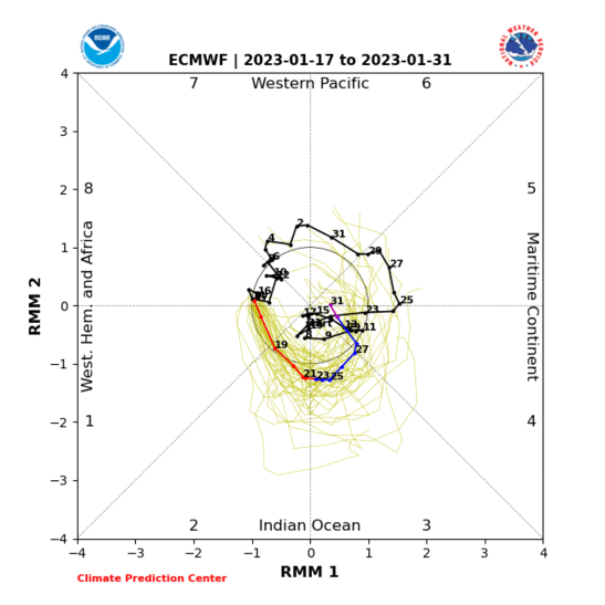

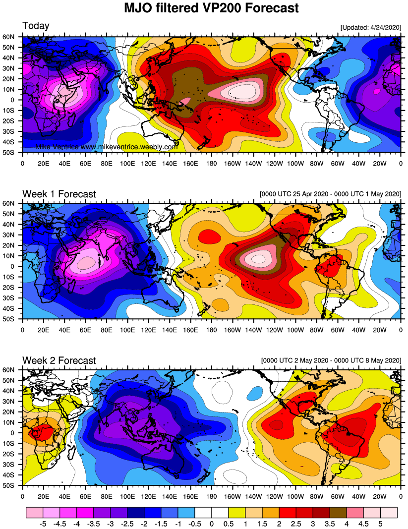
To much trough in the west - it should be centered over the NE not the WC in this phase


This is the latest time frame you woudl see correction in the models to the MJO phase 8.

Not just yet I need until this weekend (Sunday) to see if it comes aorund to the MJO phases if not I'm out till....................


To much trough in the west - it should be centered over the NE not the WC in this phase


This is the latest time frame you woudl see correction in the models to the MJO phase 8.
Not just yet I need until this weekend (Sunday) to see if it comes aorund to the MJO phases if not I'm out till....................
_________________
Mugs
AKA:King: Snow Weenie
Self Proclaimed
WINTER 2014-15 : 55.12" +.02 for 6 coatings (avg. 35")
WINTER 2015-16 Total - 29.8" (Avg 35")
WINTER 2016-17 : 39.5" so far

amugs- Advanced Forecaster - Mod

- Posts : 15091
Reputation : 213
Join date : 2013-01-07
Age : 54
Location : Hillsdale,NJ
 Re: Long Range Thread 18.0
Unfortunately, when Rocky hesitated to throw the towel in Rocky IV it arguably cost Apollo his life. Luckily the towel throwing repercussions are much less life and death here. lol.

billg315- Advanced Forecaster - Mod

- Posts : 4461
Reputation : 185
Join date : 2015-01-24
Age : 50
Location : Flemington, NJ
 Re: Long Range Thread 18.0
billg315 wrote:Unfortunately, when Rocky hesitated to throw the towel in Rocky IV it arguably cost Apollo his life. Luckily the towel throwing repercussions are much less life and death here. lol.
Yeah, but without the great man's death/ sacrifice, we never would have Creed I and Creed II. Granted, I cried in Rocky IV as I am crying over this winter.
Grselig- Senior Enthusiast

- Posts : 1408
Reputation : 140
Join date : 2013-03-04
Age : 54
Location : Wayne NJ
 Re: Long Range Thread 18.0
However, this winter we have MUGS screaming in its corner, just like Angelo Dundee did ,"Your blowing it son." Look what happened.

Grselig- Senior Enthusiast

- Posts : 1408
Reputation : 140
Join date : 2013-03-04
Age : 54
Location : Wayne NJ
 Re: Long Range Thread 18.0
Guys the towels in my hand and my arm is ready!
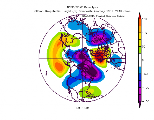
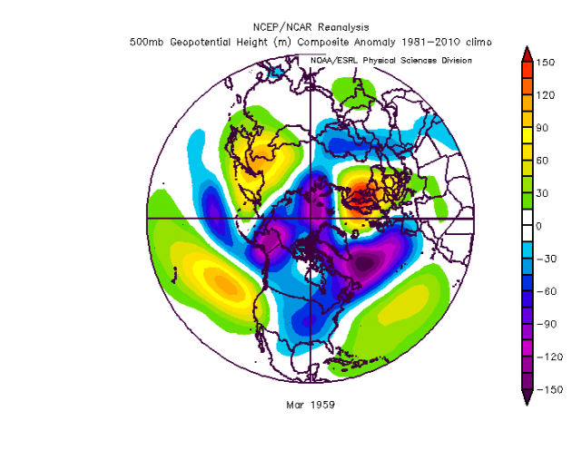
After reading Isotherm and know JB's latest blogs which talk about how the 30mb stratospheric level being positive westerly which blocks all the downwelling affects of the SSW from the 50mb level. This in turn pumped the convection off the African coast whichnlally gags it's way through the warm phases and was a steroid injection ton to the wave. In turn the Tropical Atlantic meaning the Azored High was being pumped by this as well. So basically we had coming and going and wereally really dead in the water. Nowe the analog shows a cold March. Go figure and I'd we get to phase one the storm track tjen is off the mod Atlantic and the retrograding Azore's high decouole's from the Greenland Block and allows it to take control again. Could be an interesting last few days of Feb, after the 23rdish through the first two weeks of March at best.
Here are the analog maps and maps of the Tropical Atlantic showing the SE Ridge it is more of an El Nina look in phase 7


_________________
Mugs
AKA:King: Snow Weenie
Self Proclaimed
WINTER 2014-15 : 55.12" +.02 for 6 coatings (avg. 35")
WINTER 2015-16 Total - 29.8" (Avg 35")
WINTER 2016-17 : 39.5" so far

amugs- Advanced Forecaster - Mod

- Posts : 15091
Reputation : 213
Join date : 2013-01-07
Age : 54
Location : Hillsdale,NJ
 Re: Long Range Thread 18.0
PS no more euro maps as per the EUROPEAN modelling center. So all we can post is American/Canadian models and only give a synopsis analysis of the model runs.
_________________
Mugs
AKA:King: Snow Weenie
Self Proclaimed
WINTER 2014-15 : 55.12" +.02 for 6 coatings (avg. 35")
WINTER 2015-16 Total - 29.8" (Avg 35")
WINTER 2016-17 : 39.5" so far

amugs- Advanced Forecaster - Mod

- Posts : 15091
Reputation : 213
Join date : 2013-01-07
Age : 54
Location : Hillsdale,NJ
 Re: Long Range Thread 18.0
amugs wrote:Guys the towels in my hand and my arm is ready!
After reading Isotherm and know JB's latest blogs which talk about how the 30mb stratospheric level being positive westerly which blocks all the downwelling affects of the SSW from the 50mb level. This in turn pumped the convection off the African coast whichnlally gags it's way through the warm phases and was a steroid injection ton to the wave. In turn the Tropical Atlantic meaning the Azored High was being pumped by this as well. So basically we had coming and going and wereally really dead in the water. Nowe the analog shows a cold March. Go figure and I'd we get to phase one the storm track tjen is off the mod Atlantic and the retrograding Azore's high decouole's from the Greenland Block and allows it to take control again. Could be an interesting last few days of Feb, after the 23rdish through the first two weeks of March at best.
Here are the analog maps and maps of the Tropical Atlantic showing the SE Ridge it is more of an El Nina look in phase 7
When the last towel is thrown in mostly likely a MECS hit us.
heehaw453- Advanced Forecaster

- Posts : 3904
Reputation : 86
Join date : 2014-01-20
Location : Bedminster Township, PA Elevation 600' ASL
 Re: Long Range Thread 18.0
LOL, for the first time all winter, we may actually have a low pop of the coast right at the NC/VA border.

But don't you worry winter weather lovers, the mid levels are working hard to ensure that this system gets blown straight out to sea (in black- nice jet stream, btw!), rather than phased up the coast (in red, not that it's cold enough to snow anyway).


But don't you worry winter weather lovers, the mid levels are working hard to ensure that this system gets blown straight out to sea (in black- nice jet stream, btw!), rather than phased up the coast (in red, not that it's cold enough to snow anyway).

Last edited by SENJsnowman on Fri Feb 15, 2019 6:39 am; edited 1 time in total
SENJsnowman- Senior Enthusiast

- Posts : 1186
Reputation : 61
Join date : 2017-01-06
Age : 51
Location : Bayville, NJ
 Re: Long Range Thread 18.0
I'm on board I'm not liking anything looking forward the -pna is killing us early spring may happen.

skinsfan1177- Senior Enthusiast

- Posts : 4485
Reputation : 35
Join date : 2013-01-07
Age : 46
Location : Point Pleasant Boro
 Re: Long Range Thread 18.0
Looks like a little snow for NYC northward Monday

Snow88- Senior Enthusiast

- Posts : 2193
Reputation : 4
Join date : 2013-01-09
Age : 35
Location : Brooklyn, NY
 Re: Long Range Thread 18.0
Snow? Go on get gone!

dkodgis- Senior Enthusiast

- Posts : 2492
Reputation : 98
Join date : 2013-12-29
 Re: Long Range Thread 18.0
Is there any signal for a possible event for next Wednesday, the 20th?

Irish- Pro Enthusiast

- Posts : 788
Reputation : 19
Join date : 2019-01-16
Age : 45
Location : Old Bridge, NJ
 Re: Long Range Thread 18.0
SENJsnowman wrote:LOL, for the first time all winter, we may actually have a low pop of the coast right at the NC/VA border.
But don't you worry winter weather lovers, the mid levels are working hard to ensure that this system gets blown straight out to sea (in black- nice jet stream, btw!), rather than phased up the coast (in red, not that it's cold enough to snow anyway).
I believe N & W of NYC will be cold enough to eke out a couple of inches, S of NYC and NYC itself probably not.

CPcantmeasuresnow- Wx Statistician Guru

- Posts : 7274
Reputation : 230
Join date : 2013-01-07
Age : 103
Location : Eastern Orange County, NY
Page 27 of 36 •  1 ... 15 ... 26, 27, 28 ... 31 ... 36
Page 27 of 36
Permissions in this forum:
You cannot reply to topics in this forum
 Home
Home