
 Search
12/16-12/17 Godzilla: Final Snow Map & Obsevations
Page 1 of 32 • 1, 2, 3 ... 16 ... 32 ![]()

12/16-12/17 Godzilla: Final Snow Map & Obsevations
![]() by Frank_Wx Wed Dec 16, 2020 12:54 am
by Frank_Wx Wed Dec 16, 2020 12:54 am
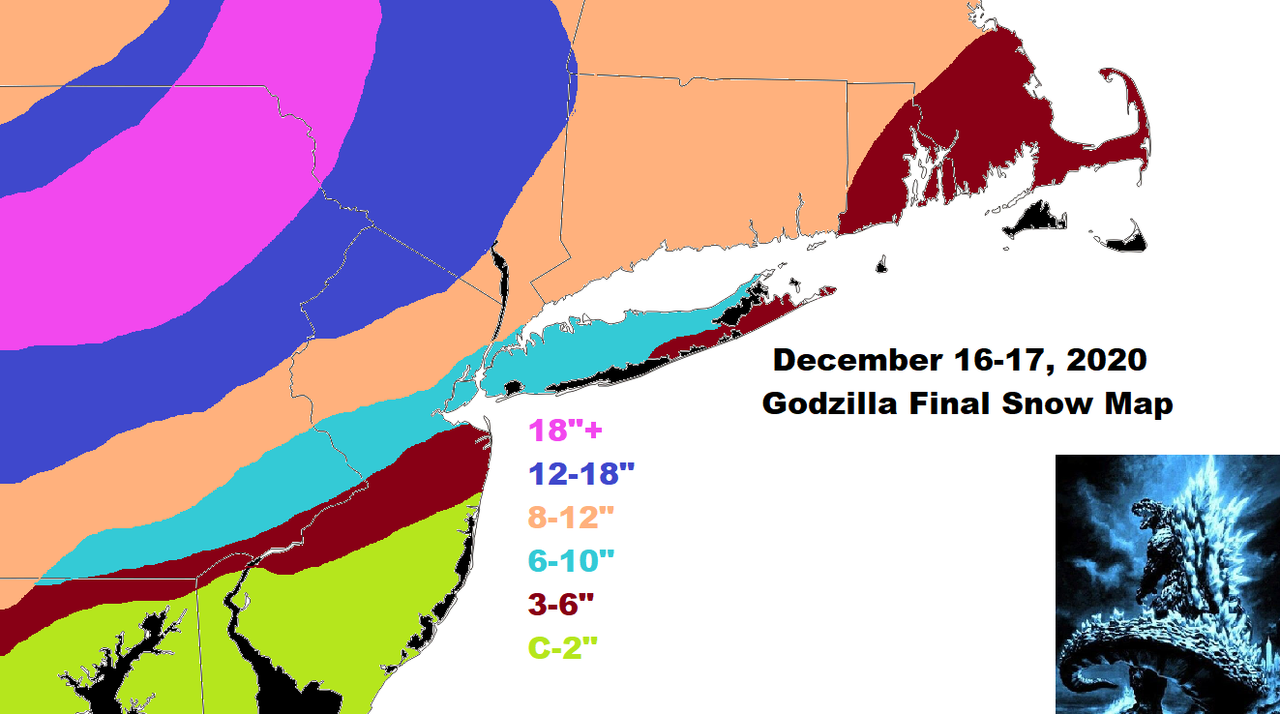
We're looking at a 2-4pm Wednesday start time (from south to north) and 4am-6am Thursday end time (from south to north).
Tomorrow I will compare actual surface and upper air features versus models and see who is leading the way in terms of calling the storm accurately.
Happy tracking!
_________________
_______________________________________________________________________________________________________
CLICK HERE to view NJ Strong Snowstorm Classifications

Frank_Wx- Godzilla Seeker

- Posts : 21305
Reputation : 328
Join date : 2013-01-05
Age : 31
Location : Jersey City, NJ -

rb924119 likes this post
Re: 12/16-12/17 Godzilla: Final Snow Map & Obsevations
![]() by Frank_Wx Wed Dec 16, 2020 1:02 am
by Frank_Wx Wed Dec 16, 2020 1:02 am
The SE cut-offs are becoming sharper run to run. Double digit snow amounts to virtually little is just a couple dozen miles apart.


_________________
_______________________________________________________________________________________________________
CLICK HERE to view NJ Strong Snowstorm Classifications
Frank_Wx- Godzilla Seeker
- Posts : 21305
Reputation : 328
Join date : 2013-01-05
Age : 31
Location : Jersey City, NJ -
Re: 12/16-12/17 Godzilla: Final Snow Map & Obsevations
![]() by Frank_Wx Wed Dec 16, 2020 1:03 am
by Frank_Wx Wed Dec 16, 2020 1:03 am

_________________
_______________________________________________________________________________________________________
CLICK HERE to view NJ Strong Snowstorm Classifications
Frank_Wx- Godzilla Seeker
- Posts : 21305
Reputation : 328
Join date : 2013-01-05
Age : 31
Location : Jersey City, NJ -
Re: 12/16-12/17 Godzilla: Final Snow Map & Obsevations
![]() by rb924119 Wed Dec 16, 2020 1:04 am
by rb924119 Wed Dec 16, 2020 1:04 am
rb924119- Meteorologist

- Posts : 6890
Reputation : 194
Join date : 2013-02-06
Age : 32
Location : Greentown, Pa
Re: 12/16-12/17 Godzilla: Final Snow Map & Obsevations
![]() by Frank_Wx Wed Dec 16, 2020 1:08 am
by Frank_Wx Wed Dec 16, 2020 1:08 am
rb924119 wrote:Nice, Frank!! Honest question: What led you to orient your higher snow totals like that instead of more southwest-northeast?
It may just be me trying to be too perfect in predicting the 'jackpot' area, but it's a combination of predicting where the initial WWA/frontogenesis banding stalls then pivots.
_________________
_______________________________________________________________________________________________________
CLICK HERE to view NJ Strong Snowstorm Classifications
Frank_Wx- Godzilla Seeker
- Posts : 21305
Reputation : 328
Join date : 2013-01-05
Age : 31
Location : Jersey City, NJ -
rb924119 likes this post
Re: 12/16-12/17 Godzilla: Final Snow Map & Obsevations
![]() by SoulSingMG Wed Dec 16, 2020 1:10 am
by SoulSingMG Wed Dec 16, 2020 1:10 am


SoulSingMG- Senior Enthusiast

- Posts : 2853
Reputation : 74
Join date : 2013-12-11
Location : Long Island City, NY
Re: 12/16-12/17 Godzilla: Final Snow Map & Obsevations
![]() by Frank_Wx Wed Dec 16, 2020 1:10 am
by Frank_Wx Wed Dec 16, 2020 1:10 am
I am not sure if I will get any work done (definitely not)
Goodnight all!
_________________
_______________________________________________________________________________________________________
CLICK HERE to view NJ Strong Snowstorm Classifications
Frank_Wx- Godzilla Seeker
- Posts : 21305
Reputation : 328
Join date : 2013-01-05
Age : 31
Location : Jersey City, NJ -
Re: 12/16-12/17 Godzilla: Final Snow Map & Obsevations
![]() by jmanley32 Wed Dec 16, 2020 1:24 am
by jmanley32 Wed Dec 16, 2020 1:24 am

jmanley32- Senior Enthusiast
- Posts : 20517
Reputation : 108
Join date : 2013-12-12
Age : 42
Location : Yonkers, NY
Re: 12/16-12/17 Godzilla: Final Snow Map & Obsevations
![]() by jmanley32 Wed Dec 16, 2020 1:25 am
by jmanley32 Wed Dec 16, 2020 1:25 am
yes very nice bout 12 to 15 for us.SoulSingMG wrote:00z Euro drops hammer on NYC/LI. I can sleep tight. G’nite all!
jmanley32- Senior Enthusiast
- Posts : 20517
Reputation : 108
Join date : 2013-12-12
Age : 42
Location : Yonkers, NY
Re: 12/16-12/17 Godzilla: Final Snow Map & Obsevations
![]() by rb924119 Wed Dec 16, 2020 3:45 am
by rb924119 Wed Dec 16, 2020 3:45 am
rb924119- Meteorologist
- Posts : 6890
Reputation : 194
Join date : 2013-02-06
Age : 32
Location : Greentown, Pa
Re: 12/16-12/17 Godzilla: Final Snow Map & Obsevations
![]() by aiannone Wed Dec 16, 2020 3:49 am
by aiannone Wed Dec 16, 2020 3:49 am
National Weather Service New York NY
347 AM EST Wed Dec 16 2020
NYZ078-080-179-162100-
/O.UPG.KOKX.WS.A.0001.201216T1900Z-201217T1800Z/
/O.EXA.KOKX.WS.W.0001.201216T1900Z-201217T1800Z/
Northwestern Suffolk-Southwestern Suffolk-Southern Nassau-
347 AM EST Wed Dec 16 2020
...WINTER STORM WARNING IN EFFECT FROM 2 PM THIS AFTERNOON TO
1 PM EST THURSDAY...
* WHAT...Heavy snow expected. Total snow accumulations of 6 to
13 inches. Winds gusting as high as 50 mph.
* WHERE...Northwestern Suffolk, Southwestern Suffolk and
Southern Nassau Counties.
* WHEN...From 2 PM this afternoon to 1 PM EST Thursday.
* IMPACTS...Travel could be very difficult to impossible. The
hazardous conditions could impact the morning or evening
commute. Gusty winds could bring down tree branches.
* ADDITIONAL INFORMATION...There is still some uncertainty with
how much, if any mixing occurs Wednesday night. Snowfall amounts
could be a bit lower than forecast along south coastal portions
of the region if more mixing occurs.
PRECAUTIONARY/PREPAREDNESS ACTIONS...
If you must travel, keep an extra flashlight, food, and water in
your vehicle in case of an emergency.
Check local Department of Transportation information services for
the latest road conditions.
_________________
-Alex Iannone-

aiannone- Senior Enthusiast - Mod

- Posts : 4814
Reputation : 92
Join date : 2013-01-07
Location : Saint James, LI (Northwest Suffolk Co.)
Re: 12/16-12/17 Godzilla: Final Snow Map & Obsevations
![]() by mmanisca Wed Dec 16, 2020 3:54 am
by mmanisca Wed Dec 16, 2020 3:54 am
products issued by NWS for: Deer Park NY Share|
Winter Storm Warning
URGENT - WINTER WEATHER MESSAGE
National Weather Service New York NY
347 AM EST Wed Dec 16 2020
NYZ078-080-179-162100-
/O.UPG.KOKX.WS.A.0001.201216T1900Z-201217T1800Z/
/O.EXA.KOKX.WS.W.0001.201216T1900Z-201217T1800Z/
Northwestern Suffolk-Southwestern Suffolk-Southern Nassau-
347 AM EST Wed Dec 16 2020
...WINTER STORM WARNING IN EFFECT FROM 2 PM THIS AFTERNOON TO
1 PM EST THURSDAY...
* WHAT...Heavy snow expected. Total snow accumulations of 6 to
13 inches. Winds gusting as high as 50 mph.
* WHERE...Northwestern Suffolk, Southwestern Suffolk and
Southern Nassau Counties.
* WHEN...From 2 PM this afternoon to 1 PM EST Thursday.
* IMPACTS...Travel could be very difficult to impossible. The
hazardous conditions could impact the morning or evening
commute. Gusty winds could bring down tree branches.
* ADDITIONAL INFORMATION...There is still some uncertainty with
how much, if any mixing occurs Wednesday night. Snowfall amounts
could be a bit lower than forecast along south coastal portions
of the region if more mixing occurs.
PRECAUTIONARY/PREPAREDNESS ACTIONS...
If you must travel, keep an extra flashlight, food, and water in
your vehicle in case of an emergency.
Check local Department of Transportation information services for
the latest road conditions.

mmanisca- Pro Enthusiast

- Posts : 299
Reputation : 3
Join date : 2013-01-23
Age : 65
Location : Deer Park, Long Island
Re: 12/16-12/17 Godzilla: Final Snow Map & Obsevations
![]() by phil155 Wed Dec 16, 2020 6:25 am
by phil155 Wed Dec 16, 2020 6:25 am

phil155- Pro Enthusiast
- Posts : 475
Reputation : 4
Join date : 2019-12-16
Re: 12/16-12/17 Godzilla: Final Snow Map & Obsevations
![]() by docstox12 Wed Dec 16, 2020 6:37 am
by docstox12 Wed Dec 16, 2020 6:37 am

docstox12- Wx Statistician Guru

- Posts : 8507
Reputation : 222
Join date : 2013-01-07
Age : 73
Location : Monroe NY
CPcantmeasuresnow likes this post
Re: 12/16-12/17 Godzilla: Final Snow Map & Obsevations
![]() by billg315 Wed Dec 16, 2020 6:45 am
by billg315 Wed Dec 16, 2020 6:45 am

billg315- Advanced Forecaster - Mod
- Posts : 4469
Reputation : 185
Join date : 2015-01-24
Age : 50
Location : Flemington, NJ
Re: 12/16-12/17 Godzilla: Final Snow Map & Obsevations
![]() by billg315 Wed Dec 16, 2020 6:48 am
by billg315 Wed Dec 16, 2020 6:48 am
billg315- Advanced Forecaster - Mod
- Posts : 4469
Reputation : 185
Join date : 2015-01-24
Age : 50
Location : Flemington, NJ
Re: 12/16-12/17 Godzilla: Final Snow Map & Obsevations
![]() by mmanisca Wed Dec 16, 2020 6:53 am
by mmanisca Wed Dec 16, 2020 6:53 am
mmanisca- Pro Enthusiast
- Posts : 299
Reputation : 3
Join date : 2013-01-23
Age : 65
Location : Deer Park, Long Island
Re: 12/16-12/17 Godzilla: Final Snow Map & Obsevations
![]() by billg315 Wed Dec 16, 2020 6:59 am
by billg315 Wed Dec 16, 2020 6:59 am
billg315- Advanced Forecaster - Mod
- Posts : 4469
Reputation : 185
Join date : 2015-01-24
Age : 50
Location : Flemington, NJ
Re: 12/16-12/17 Godzilla: Final Snow Map & Obsevations
![]() by aiannone Wed Dec 16, 2020 6:59 am
by aiannone Wed Dec 16, 2020 6:59 am

_________________
-Alex Iannone-
aiannone- Senior Enthusiast - Mod
- Posts : 4814
Reputation : 92
Join date : 2013-01-07
Location : Saint James, LI (Northwest Suffolk Co.)
Re: 12/16-12/17 Godzilla: Final Snow Map & Obsevations
![]() by bloc1357 Wed Dec 16, 2020 7:06 am
by bloc1357 Wed Dec 16, 2020 7:06 am
bloc1357- Pro Enthusiast
- Posts : 344
Reputation : 10
Join date : 2013-03-05
Age : 47
Location : West Babylon, NY - 11704
Re: 12/16-12/17 Godzilla: Final Snow Map & Obsevations
![]() by nutleyblizzard Wed Dec 16, 2020 7:10 am
by nutleyblizzard Wed Dec 16, 2020 7:10 am
There was talk last night on anotherbillg315 wrote:It’s interesting because the 6z GFS tracks the Low over South Jersey and the 500mb seems to track over NWNJ/NEPA which is exactly what rb has been pointing out and what logically is not good news for us, but in its surface output stands fast to its 10-15” area-wide snowfall with little mixing. So I don’t know what to think. It does pick up that dry slotting that every model is now showing - and of course the one consistency in this thing is the dry slot is modeled right near or over my backyard.
chat room from a met that the upper levels should be more stacked than what the models depict and that the upper low should be further south. At this juncture it really doesn’t matter anymore since we’re in now casting.

nutleyblizzard- Senior Enthusiast
- Posts : 1952
Reputation : 41
Join date : 2014-01-30
Age : 58
Location : Nutley, new jersey
Re: 12/16-12/17 Godzilla: Final Snow Map & Obsevations
![]() by mikeypizano Wed Dec 16, 2020 7:10 am
by mikeypizano Wed Dec 16, 2020 7:10 am
Frank_Wx wrote:rb924119 wrote:Nice, Frank!! Honest question: What led you to orient your higher snow totals like that instead of more southwest-northeast?
It may just be me trying to be too perfect in predicting the 'jackpot' area, but it's a combination of predicting where the initial WWA/frontogenesis banding stalls then pivots.
Everything seems to show me in the jackpot zone so for once I will see the big snow. I almost always get screwed on coastals.

mikeypizano- Pro Enthusiast
- Posts : 1118
Reputation : 66
Join date : 2017-01-05
Age : 35
Location : Wilkes-Barre/Scranton, PA
Re: 12/16-12/17 Godzilla: Final Snow Map & Obsevations
![]() by CnWestMilford76 Wed Dec 16, 2020 7:11 am
by CnWestMilford76 Wed Dec 16, 2020 7:11 am

Good morning form West Milford NJ!
I bring you Bernie Rayno.
CnWestMilford76- Posts : 30
Reputation : 0
Join date : 2020-12-15
Re: 12/16-12/17 Godzilla: Final Snow Map & Obsevations
![]() by Frank_Wx Wed Dec 16, 2020 7:13 am
by Frank_Wx Wed Dec 16, 2020 7:13 am


_________________
_______________________________________________________________________________________________________
CLICK HERE to view NJ Strong Snowstorm Classifications
Frank_Wx- Godzilla Seeker
- Posts : 21305
Reputation : 328
Join date : 2013-01-05
Age : 31
Location : Jersey City, NJ -
Re: 12/16-12/17 Godzilla: Final Snow Map & Obsevations
![]() by sroc4 Wed Dec 16, 2020 7:15 am
by sroc4 Wed Dec 16, 2020 7:15 am
billg315 wrote:It’s interesting because the 6z GFS tracks the Low over South Jersey and the 500mb seems to track over NWNJ/NEPA which is exactly what rb has been pointing out and what logically is not good news for us, but in its surface output stands fast to its 10-15” area-wide snowfall with little mixing. So I don’t know what to think. It does pick up that dry slotting that every model is now showing - and of course the one consistency in this thing is the dry slot is modeled right near or over my backyard.
500mb never closes off at least not until well past us. its 850 and 700mb closed low that you need to follow to see where the warmth and or dry slot will occur. GFS and Euro cont to insist that 850 is just to the south of LI.
This is 850: The positioning on the 6x GFS is such that it keeps the freezing line just south of LI, but as soon as it scoots by temps at this level crash further. The dashed line however is where models like the NAM and CMC have it pass. This would bring the freezing line up into the coastal plain somewhere lending its slef to mixing with sleet, rain and possibly freezing rain depending on where your surface temps are siting.


You really need to look at the sounding though to check all levels of the mid levels for the warm nose.
As you can see first image is a sounding just east of my house. Black horizontal line represents where the atmosphere goes slight above freezing just below the 100mb mark or about 400feet above sea level. whereas the second sounding is one into Nassau county to my west. Temps throughout all are below freezing


Withall due respect to you Ray but I think you may be underplaying the cold air. While others may be reading the results of a model output incorrectly verbatim I think it is well within reason to side with the models that have that subtle shift to the exact local of the mid level lows. Euro and GFS cont to hold steadfast in keeping 850 just south of LI. If true even the NS of LI will get close to if not exceed double digit totals. If nbot then the wam nose sneaks in and mixing holds down totals.
There is no doubt we have officially approached now cast time. I strongly urge people to go to this site today and tonight to monitor real time observations at the various levels. At the top of he page you can hover your mouse over change sector and click on the NE rectangle for a zoomed in version when we get to later this afternoon. Also hover over Upper Air and toggle through the 925, 850, and 700mb levels as we head into tonight to follow where there closed lows actually track. Trust me...if the track south of or just south of LI the coastal plain will stay white or mostly white. If its center is over NYC and LI then totals will be surpressed.
https://www.spc.noaa.gov/exper/mesoanalysis/new/viewsector.php?sector=19
_________________
"In weather and in life, there's no winning and losing; there's only winning and learning."
WINTER 2012/2013 TOTALS 43.65"WINTER 2017/2018 TOTALS 62.85" WINTER 2022/2023 TOTALS 4.9"
WINTER 2013/2014 TOTALS 64.85"WINTER 2018/2019 TOTALS 14.25" WINTER 2023/2024 TOTALS 13.1"
WINTER 2014/2015 TOTALS 71.20"WINTER 2019/2020 TOTALS 6.35"
WINTER 2015/2016 TOTALS 35.00"WINTER 2020/2021 TOTALS 37.75"
WINTER 2016/2017 TOTALS 42.25"WINTER 2021/2022 TOTALS 31.65"

sroc4- Admin
- Posts : 8331
Reputation : 301
Join date : 2013-01-07
Location : Wading River, LI
mmanisca, rb924119, Grselig and SoulSingMG like this post
Page 1 of 32 • 1, 2, 3 ... 16 ... 32 ![]()