JAN 3rd Storm: I-84 First Snow of 2021
+19
DAYBLAZER
docstox12
Vinnydula
phil155
frank 638
weatherwatchermom
brownie
essexcountypete
kalleg
dkodgis
jmanley32
aiannone
sroc4
heehaw453
hyde345
Dunnzoo
amugs
rb924119
Frank_Wx
23 posters
Page 1 of 5 • 1, 2, 3, 4, 5 
 JAN 3rd Storm: I-84 First Snow of 2021
Hi everyone -
We're ringing in the New Year with a nice little snowstorm for those far NW of NYC near I-84. Models are still bouncing around with how far S&E the cold air gets which would give more places like NW NJ and those south of 84 accumulating snow as well.

This H5 map is valid for Saturday afternoon. The steering pattern shows much of what we have been use to so far this season. +EPO/+AO and a neutral to east based negative NAO. Virtually non-existent arctic air for the northeast. The Polar Vortex is hiding out in the Arctic circle and smaller versions of it are spinning in the northern Pacific (hence +EPO). Speaking of the Pacific, from this map you can kind of make out the strong Pacific jet stream by the tight clustering of height contour lines off the west coast. But here is a clearer view using the 250mb map:

The shades of purple/pink out in the northern Pacific with shades of red extending into the west coast prove just how disruptive this jet stream has been to our pattern. The Pacific is bombarded with waves of energy, or storms, originating all the way out in the west-central Pacific Ocean. These storms prevent areas of High Pressure, or ridging, from developing over the EPO and PNA domains which are critical to ensuring arctic air is displaced from the north pole into the CONUS. Although we have seen flashes of colder than normal weather so far this winter (remember the PNA spike in December which partially lead to our snowstorm?), it has been pretty absent the last couple of weeks. Yes it has been cold, but that is simply due to the fact it is our coldest time of year from a climatology standpoint.
Bringing this discussion back to Sunday's storm, from the 500mb map you can see how there is a jet streak present over the northeast and a closed off trough near Arkansas. Ahead of the trough, the southeast ridge is flexing its muscle and milder than normal air flowing up the east coast and into our area. Our coldest and snowiest storms tend to occur when our 500mb trough closes off east of the Mississippi and we begin seeing the trough's axis tilt from neutral to negative. In this case, the 500mb trough closed off very early (again!) mainly due to the poor steering pattern I've already talked about. The only way to combat the southeast ridge / warm air in this set-up is by having High Pressure to the north near Buffalo. This would give us a cold air mass that is needed to keep precipitation in the form of snow. Unfortunately, that HP is displaced too far east-northeast for areas like I-95 and points S&E to benefit. However, I-84 and points north will be cold enough to support snowfall.
The other issue is that the closed 500mb low that I mentioned earlier will then track well N&W of our area. It's important to know the mid-level lows like 500mb, 700mb and 850mb should track south and/or east to experience the best dynamics and ensure boundary layer temperatures are below freezing. Here is a snapshot of the GFS at 500mb and notice how the closed low is tracking over Upstate NY.

What's interesting is, despite the mid-level lows tracking well NW, the RGEM shows this much snow falling over our area:

This model is an outlier among the others, but it has impressive bands of snow sweeping across NW NJ because of how it handles 700mb vorticity. That said, we're looking at a VERY weak surface low tracking east of the 70/40 benchmark. GFS has it at around 1005mb. That is like weak sauce and does not give me confidence the RGEM is correct in predicting such strong dynamics. Factor that with poor placement of the mid-level lows, and this is a horrible recipe for significant snow. But I still believe in a 4"+ snowfall occurring for I-84 and points north. I think a 2-4" snow event is also in the cards for NW NJ and those south of I-84. Some places north of 84 are likely to exceed 6 inches of snow. I would have drawn a snow map, but my personal computer is getting fixed and my work computer does not have my usual template that I use
Things to watch:
Does the 2-4" line extend further S&E toward I-95 (like Morris county as the cut-off)? My guess is no unfortunately, and those just N&W of 95 will see little to no snow from this. However, up by Sussex and Orange counties I think 2-4" is a safe call with opportunity for more if RGEM gets its way!
We're ringing in the New Year with a nice little snowstorm for those far NW of NYC near I-84. Models are still bouncing around with how far S&E the cold air gets which would give more places like NW NJ and those south of 84 accumulating snow as well.

This H5 map is valid for Saturday afternoon. The steering pattern shows much of what we have been use to so far this season. +EPO/+AO and a neutral to east based negative NAO. Virtually non-existent arctic air for the northeast. The Polar Vortex is hiding out in the Arctic circle and smaller versions of it are spinning in the northern Pacific (hence +EPO). Speaking of the Pacific, from this map you can kind of make out the strong Pacific jet stream by the tight clustering of height contour lines off the west coast. But here is a clearer view using the 250mb map:

The shades of purple/pink out in the northern Pacific with shades of red extending into the west coast prove just how disruptive this jet stream has been to our pattern. The Pacific is bombarded with waves of energy, or storms, originating all the way out in the west-central Pacific Ocean. These storms prevent areas of High Pressure, or ridging, from developing over the EPO and PNA domains which are critical to ensuring arctic air is displaced from the north pole into the CONUS. Although we have seen flashes of colder than normal weather so far this winter (remember the PNA spike in December which partially lead to our snowstorm?), it has been pretty absent the last couple of weeks. Yes it has been cold, but that is simply due to the fact it is our coldest time of year from a climatology standpoint.
Bringing this discussion back to Sunday's storm, from the 500mb map you can see how there is a jet streak present over the northeast and a closed off trough near Arkansas. Ahead of the trough, the southeast ridge is flexing its muscle and milder than normal air flowing up the east coast and into our area. Our coldest and snowiest storms tend to occur when our 500mb trough closes off east of the Mississippi and we begin seeing the trough's axis tilt from neutral to negative. In this case, the 500mb trough closed off very early (again!) mainly due to the poor steering pattern I've already talked about. The only way to combat the southeast ridge / warm air in this set-up is by having High Pressure to the north near Buffalo. This would give us a cold air mass that is needed to keep precipitation in the form of snow. Unfortunately, that HP is displaced too far east-northeast for areas like I-95 and points S&E to benefit. However, I-84 and points north will be cold enough to support snowfall.
The other issue is that the closed 500mb low that I mentioned earlier will then track well N&W of our area. It's important to know the mid-level lows like 500mb, 700mb and 850mb should track south and/or east to experience the best dynamics and ensure boundary layer temperatures are below freezing. Here is a snapshot of the GFS at 500mb and notice how the closed low is tracking over Upstate NY.

What's interesting is, despite the mid-level lows tracking well NW, the RGEM shows this much snow falling over our area:

This model is an outlier among the others, but it has impressive bands of snow sweeping across NW NJ because of how it handles 700mb vorticity. That said, we're looking at a VERY weak surface low tracking east of the 70/40 benchmark. GFS has it at around 1005mb. That is like weak sauce and does not give me confidence the RGEM is correct in predicting such strong dynamics. Factor that with poor placement of the mid-level lows, and this is a horrible recipe for significant snow. But I still believe in a 4"+ snowfall occurring for I-84 and points north. I think a 2-4" snow event is also in the cards for NW NJ and those south of I-84. Some places north of 84 are likely to exceed 6 inches of snow. I would have drawn a snow map, but my personal computer is getting fixed and my work computer does not have my usual template that I use
Things to watch:
Does the 2-4" line extend further S&E toward I-95 (like Morris county as the cut-off)? My guess is no unfortunately, and those just N&W of 95 will see little to no snow from this. However, up by Sussex and Orange counties I think 2-4" is a safe call with opportunity for more if RGEM gets its way!
_________________
_______________________________________________________________________________________________________
CLICK HERE to view NJ Strong Snowstorm Classifications
rb924119 likes this post
 Re: JAN 3rd Storm: I-84 First Snow of 2021
This is a great write up, per usual, Frank!! I’m interested to see how modeling may (or may not) adjust in the next 48-60 hours explicitly on the accounts of what you mentioned above. There’s certainly an interesting battle going on between the modeling, and I’m also interested because of our earlier discussions :p
rb924119- Meteorologist

- Posts : 6890
Reputation : 194
Join date : 2013-02-06
Age : 32
Location : Greentown, Pa
 Re: JAN 3rd Storm: I-84 First Snow of 2021
Last edited by amugs on Fri Jan 01, 2021 11:13 pm; edited 1 time in total
_________________
Mugs
AKA:King: Snow Weenie
Self Proclaimed
WINTER 2014-15 : 55.12" +.02 for 6 coatings (avg. 35")
WINTER 2015-16 Total - 29.8" (Avg 35")
WINTER 2016-17 : 39.5" so far

amugs- Advanced Forecaster - Mod

- Posts : 15093
Reputation : 213
Join date : 2013-01-07
Age : 54
Location : Hillsdale,NJ
 Re: JAN 3rd Storm: I-84 First Snow of 2021
amugs wrote:0Z NAM hot off the presses
Heck whiten the ground with a minor accumulation and I'll take it.
mugsy, images aren't showing again
_________________
Janet
Snowfall winter of 2023-2024 17.5"
Snowfall winter of 2022-2023 6.0"
Snowfall winter of 2021-2022 17.6" 1" sleet 2/25/22
Snowfall winter of 2020-2021 51.1"
Snowfall winter of 2019-2020 8.5"
Snowfall winter of 2018-2019 25.1"
Snowfall winter of 2017-2018 51.9"
Snowfall winter of 2016-2017 45.6"
Snowfall winter of 2015-2016 29.5"
Snowfall winter of 2014-2015 50.55"
Snowfall winter of 2013-2014 66.5"
Dunnzoo- Senior Enthusiast - Mod

- Posts : 4892
Reputation : 68
Join date : 2013-01-11
Age : 62
Location : Westwood, NJ

hyde345- Pro Enthusiast

- Posts : 1082
Reputation : 48
Join date : 2013-01-08
Location : Hyde Park, NY

hyde345- Pro Enthusiast

- Posts : 1082
Reputation : 48
Join date : 2013-01-08
Location : Hyde Park, NY
 Re: JAN 3rd Storm: I-84 First Snow of 2021
I 80 North storm peeps.
_________________
Mugs
AKA:King: Snow Weenie
Self Proclaimed
WINTER 2014-15 : 55.12" +.02 for 6 coatings (avg. 35")
WINTER 2015-16 Total - 29.8" (Avg 35")
WINTER 2016-17 : 39.5" so far

amugs- Advanced Forecaster - Mod

- Posts : 15093
Reputation : 213
Join date : 2013-01-07
Age : 54
Location : Hillsdale,NJ

hyde345- Pro Enthusiast

- Posts : 1082
Reputation : 48
Join date : 2013-01-08
Location : Hyde Park, NY
 Re: JAN 3rd Storm: I-84 First Snow of 2021
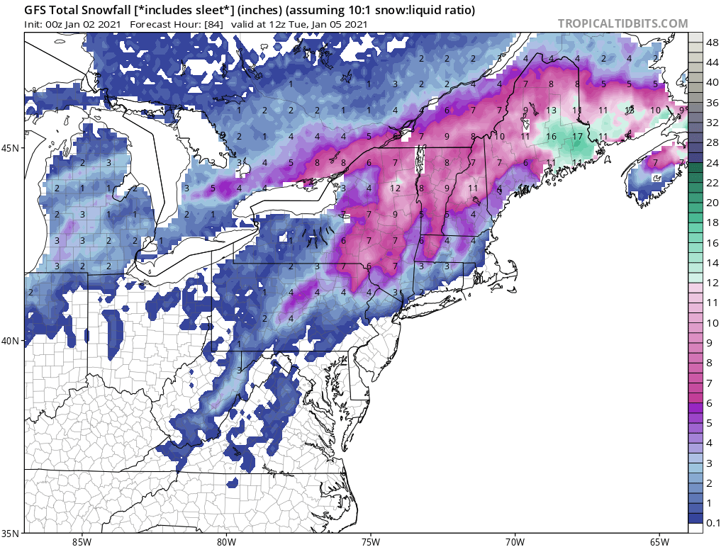
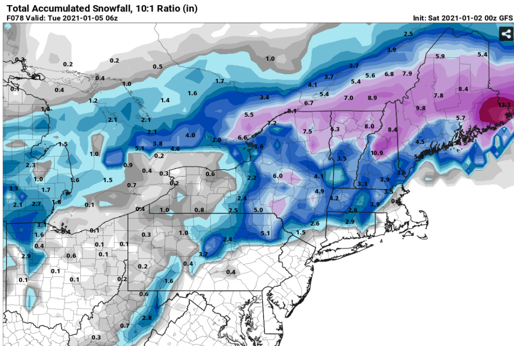
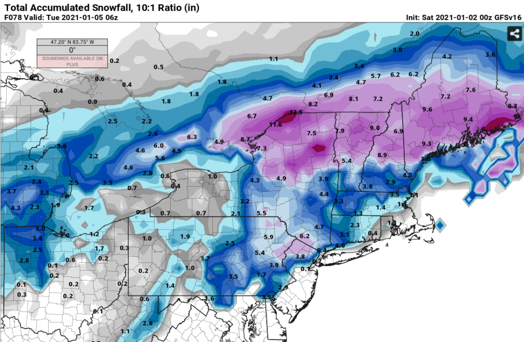
The mesoscale models are being very aggressive with the evolution of the storm thereby maturing it quickly. The GFS and to some extent the Euro basically don't mature the storm until Gulf of Maine. Mind you this is 48 hours out now with such differences. If we get the kind of snow in the I84 that these mesoscale models are projecting then the GFS should be taken out back and shot. No questions asked. The Para GFS is 3-6 NW of 95. I kind of like the Para solution but I'd shave off just an inch or so.
GFS 0Z
Para GFS 0Z
GFS 0Z

Para GFS 0Z

heehaw453- Advanced Forecaster

- Posts : 3906
Reputation : 86
Join date : 2014-01-20
Location : Bedminster Township, PA Elevation 600' ASL
lglickman1 likes this post
 Re: JAN 3rd Storm: I-84 First Snow of 2021
_________________
_______________________________________________________________________________________________________
CLICK HERE to view NJ Strong Snowstorm Classifications
 Re: JAN 3rd Storm: I-84 First Snow of 2021
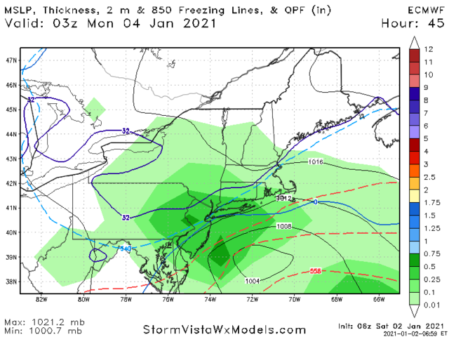
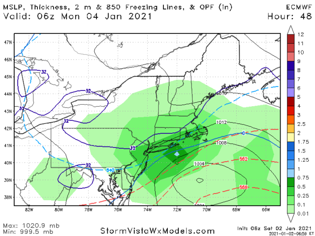
Looks like we’re seeing a small S&E shift. Euro shows heaviest snow across NW NJ, NEPA and SNY. The 6z RGEM shows the same


_________________
_______________________________________________________________________________________________________
CLICK HERE to view NJ Strong Snowstorm Classifications
 Re: JAN 3rd Storm: I-84 First Snow of 2021
GFS is an I-84 and north storm while EURO/RGEM show heaviest accumulations south of there. NAM is a blend of all 3 which is what I’m currently predicting


_________________
_______________________________________________________________________________________________________
CLICK HERE to view NJ Strong Snowstorm Classifications
heehaw453- Advanced Forecaster

- Posts : 3906
Reputation : 86
Join date : 2014-01-20
Location : Bedminster Township, PA Elevation 600' ASL
 Re: JAN 3rd Storm: I-84 First Snow of 2021
Frank_Wx wrote:GFS is an I-84 and north storm while EURO/RGEM show heaviest accumulations south of there. NAM is a blend of all 3 which is what I’m currently predicting
Here is latest NAM. Weaker storm

_________________
_______________________________________________________________________________________________________
CLICK HERE to view NJ Strong Snowstorm Classifications
 Re: JAN 3rd Storm: I-84 First Snow of 2021
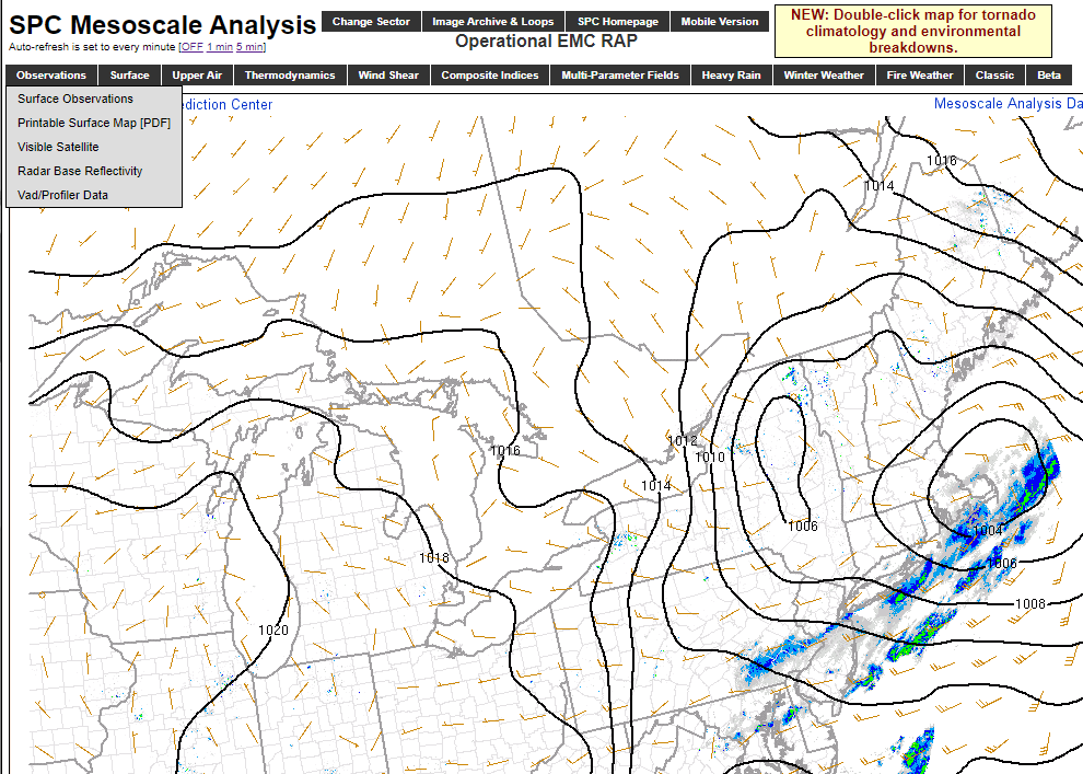
The other thing I'm interested in is how long does this Low take to get to the 50/50 area? The slower this departs the more south this Sunday system most likely will be. The position of this low is nowhere near where the GFS had it only yesterday. It's much more south east which means there was a faster transfer from the primary to this. I feel the blocking affected it more than what was modeled only yesterday.

heehaw453- Advanced Forecaster

- Posts : 3906
Reputation : 86
Join date : 2014-01-20
Location : Bedminster Township, PA Elevation 600' ASL
 Re: JAN 3rd Storm: I-84 First Snow of 2021
Another example of models under doing the extent of the -NAO. Maine has gone from being forecasted for flurries to a 6”+ snowstorm Monday night into Tuesday.
When looking at the long range it’s important to remember that any storms to affect our area won’t show up on models until under 4-5 days before the start date. That’s typically how it goes under a -NAO regime.
When looking at the long range it’s important to remember that any storms to affect our area won’t show up on models until under 4-5 days before the start date. That’s typically how it goes under a -NAO regime.
_________________
_______________________________________________________________________________________________________
CLICK HERE to view NJ Strong Snowstorm Classifications
SENJsnowman likes this post
 Re: JAN 3rd Storm: I-84 First Snow of 2021
If I'm on LI North Shore I'm liking the 12Z Euro. I'm thinking those folks are going to do much better than 12/5 this go around.
heehaw453- Advanced Forecaster

- Posts : 3906
Reputation : 86
Join date : 2014-01-20
Location : Bedminster Township, PA Elevation 600' ASL
 Re: JAN 3rd Storm: I-84 First Snow of 2021
12Z Euro says a tick colder again - feeling Mr NAO press

925 Temps - Cold enough

White rain for some at the start then all snow

Snowmap

Zoomed in


925 Temps - Cold enough

White rain for some at the start then all snow

Snowmap

Zoomed in

_________________
Mugs
AKA:King: Snow Weenie
Self Proclaimed
WINTER 2014-15 : 55.12" +.02 for 6 coatings (avg. 35")
WINTER 2015-16 Total - 29.8" (Avg 35")
WINTER 2016-17 : 39.5" so far

amugs- Advanced Forecaster - Mod

- Posts : 15093
Reputation : 213
Join date : 2013-01-07
Age : 54
Location : Hillsdale,NJ
 Re: JAN 3rd Storm: I-84 First Snow of 2021
amugs wrote:12Z Euro says a tick colder again - feeling Mr NAO press
925 Temps - Cold enough
White rain for some at the start then all snow
Snowmap
Zoomed in
Yep. The warm nose will probably be lower this time more around 925's than on 12/17 where is was between 700 and 800. Definitely cannot underestimate the -NAO. We shall see, but if only we had some decent cold to work with it'd be a slam dunk because the track is favorable.
heehaw453- Advanced Forecaster

- Posts : 3906
Reputation : 86
Join date : 2014-01-20
Location : Bedminster Township, PA Elevation 600' ASL
 Re: JAN 3rd Storm: I-84 First Snow of 2021
heehaw453 wrote:If I'm on LI North Shore I'm liking the 12Z Euro. I'm thinking those folks are going to do much better than 12/5 this go around.
Likely true. Dec 5th system was on the edge. I said it before. Climatology is now on our side. And with this track SE of the Bm LI esp NS likely overachieved. But like frank said lack of true cold air will still keep it close. Even slight colder air to the north and it’s a done deal
_________________
"In weather and in life, there's no winning and losing; there's only winning and learning."
WINTER 2012/2013 TOTALS 43.65"WINTER 2017/2018 TOTALS 62.85" WINTER 2022/2023 TOTALS 4.9"
WINTER 2013/2014 TOTALS 64.85"WINTER 2018/2019 TOTALS 14.25" WINTER 2023/2024 TOTALS 13.1"
WINTER 2014/2015 TOTALS 71.20"WINTER 2019/2020 TOTALS 6.35"
WINTER 2015/2016 TOTALS 35.00"WINTER 2020/2021 TOTALS 37.75"
WINTER 2016/2017 TOTALS 42.25"WINTER 2021/2022 TOTALS 31.65"

sroc4- Admin

- Posts : 8331
Reputation : 301
Join date : 2013-01-07
Location : Wading River, LI
 Re: JAN 3rd Storm: I-84 First Snow of 2021
Refer to my post from Mike Sullivan the other night about the NAO. We forget the power of this even when its transitioning because we've been head faked by it and become doubters.
_________________
Mugs
AKA:King: Snow Weenie
Self Proclaimed
WINTER 2014-15 : 55.12" +.02 for 6 coatings (avg. 35")
WINTER 2015-16 Total - 29.8" (Avg 35")
WINTER 2016-17 : 39.5" so far

amugs- Advanced Forecaster - Mod

- Posts : 15093
Reputation : 213
Join date : 2013-01-07
Age : 54
Location : Hillsdale,NJ
heehaw453- Advanced Forecaster

- Posts : 3906
Reputation : 86
Join date : 2014-01-20
Location : Bedminster Township, PA Elevation 600' ASL
 Re: JAN 3rd Storm: I-84 First Snow of 2021
That pesky euro insists on snow down into MbY
_________________
"In weather and in life, there's no winning and losing; there's only winning and learning."
WINTER 2012/2013 TOTALS 43.65"WINTER 2017/2018 TOTALS 62.85" WINTER 2022/2023 TOTALS 4.9"
WINTER 2013/2014 TOTALS 64.85"WINTER 2018/2019 TOTALS 14.25" WINTER 2023/2024 TOTALS 13.1"
WINTER 2014/2015 TOTALS 71.20"WINTER 2019/2020 TOTALS 6.35"
WINTER 2015/2016 TOTALS 35.00"WINTER 2020/2021 TOTALS 37.75"
WINTER 2016/2017 TOTALS 42.25"WINTER 2021/2022 TOTALS 31.65"

sroc4- Admin

- Posts : 8331
Reputation : 301
Join date : 2013-01-07
Location : Wading River, LI
 Re: JAN 3rd Storm: I-84 First Snow of 2021
sroc4 wrote:That pesky euro insists on snow down into MbY
The track of the H5 is very good for North Shore. I also believe that area could be very pleasantly surprised with this. The only reason we aren't more excited is the air mass quite honestly.
NYC may also get quite a surprise out of this.
heehaw453- Advanced Forecaster

- Posts : 3906
Reputation : 86
Join date : 2014-01-20
Location : Bedminster Township, PA Elevation 600' ASL
sroc4 likes this post
 Re: JAN 3rd Storm: I-84 First Snow of 2021
heehaw453 wrote:sroc4 wrote:That pesky euro insists on snow down into MbY
The track of the H5 is very good for North Shore. I also believe that area could be very pleasantly surprised with this. The only reason we aren't more excited is the air mass quite honestly.
NYC may also get quite a surprise out of this.
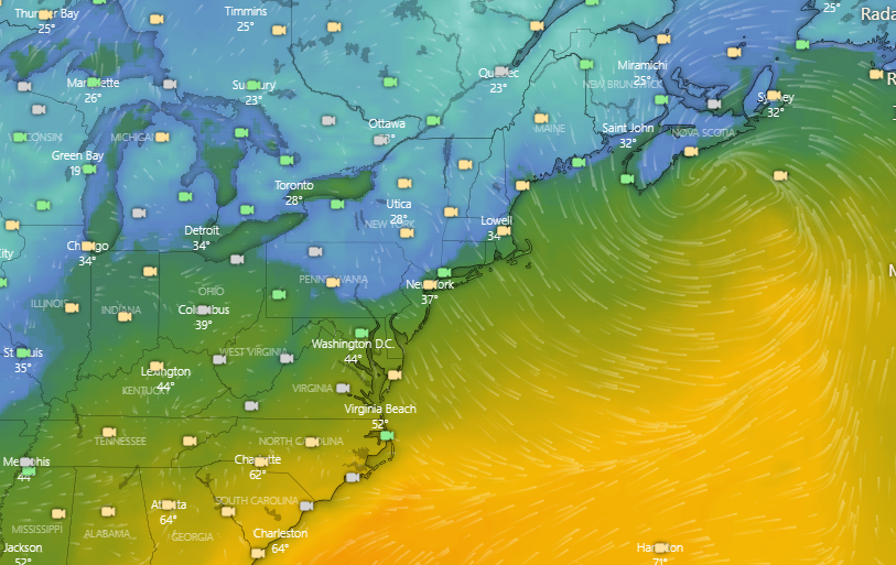
I was talking to Scott earlier how a few weeks ago when we had a coastal with marginal cold air we had flakes mixing in when winds went due north and sound temps were in the mid 50s. Now we have sound temps in the low 40s (around 42) and a bit better if an airmass to work with. Models have due north winds at the time of the heaviest Precip with the possible ccb band swinging through. That might be enough to thump. We will see.
_________________
-Alex Iannone-

aiannone- Senior Enthusiast - Mod

- Posts : 4814
Reputation : 92
Join date : 2013-01-07
Location : Saint James, LI (Northwest Suffolk Co.)
sroc4 likes this post
Page 1 of 5 • 1, 2, 3, 4, 5 
Permissions in this forum:
You cannot reply to topics in this forum|
|
|

 Home
Home


