
 Search
Thursday, 02/18: The Next One
Page 1 of 5 • 1, 2, 3, 4, 5 ![]()

Thursday, 02/18: The Next One
![]() by Frank_Wx Mon Feb 15, 2021 9:12 am
by Frank_Wx Mon Feb 15, 2021 9:12 am
Another messy storm is likely to bring snow, ice and rain this Thursday into Friday morning. After today's storm departs to our north and east, High Pressure moves in and replenishes our area with fresh arctic air. Here is the 1033mb High valid for Wednesday morning.

Once we get to Thursday, a brand new low pressure system coming out of Texas (can you believe they will get ANOTHER winter storm later this week??) will move east-northeast toward our area. The reason why Texas and areas much further west than us are seeing snow is because that's where the trough axis has set-up. Anomalous cold is dropping dead center into the U.S. which allows these low pressure storms to mature in the SW CONUS. Whereas earlier this month, the trough axis was over the eastern part of this country and storms were developing a lot closer to the coastline.
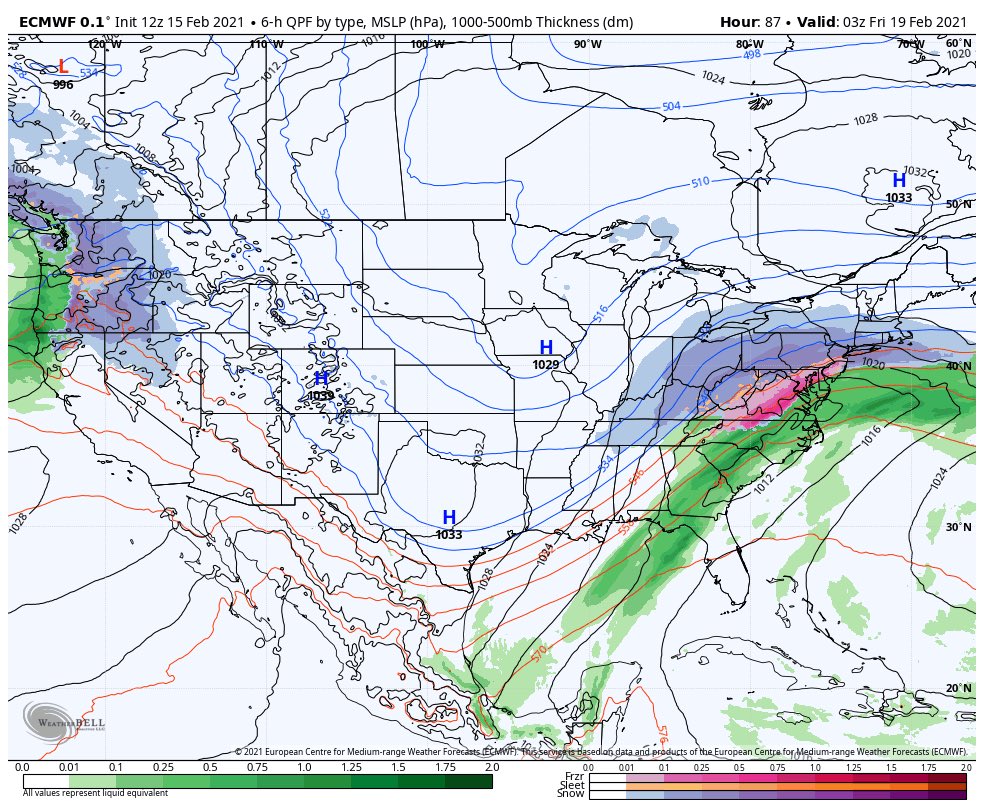
Here's our new storm valid Thursday evening. Notice how - once again - the primary low pressure is 'cutting' west into Ohio. As you all know by now, when these storms cut it allows warmer air to infiltrate the boundary layers of our atmosphere and turn precipitation over from snow to ice/rain. Keep in mind however that we're under pretty cold temperatures BEFORE this happens, and we're already getting snow by this point of time. Then we see snow changeover to mix and then to rain as temperatures gradually rise as a result of this primary low cutting into OH.

What happens thereafter is a little tricky. Last night's EURO Ensembles show a secondary low pressure developing off the coast. This is called a 'transfer' which is exactly what happened with the February 1st Roidzilla. In essence, this would keep some parts of our area below freezing and not see a changeover to rain. However, the issue is at the 500mb level.
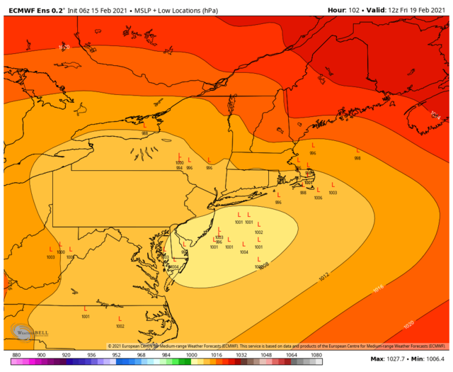
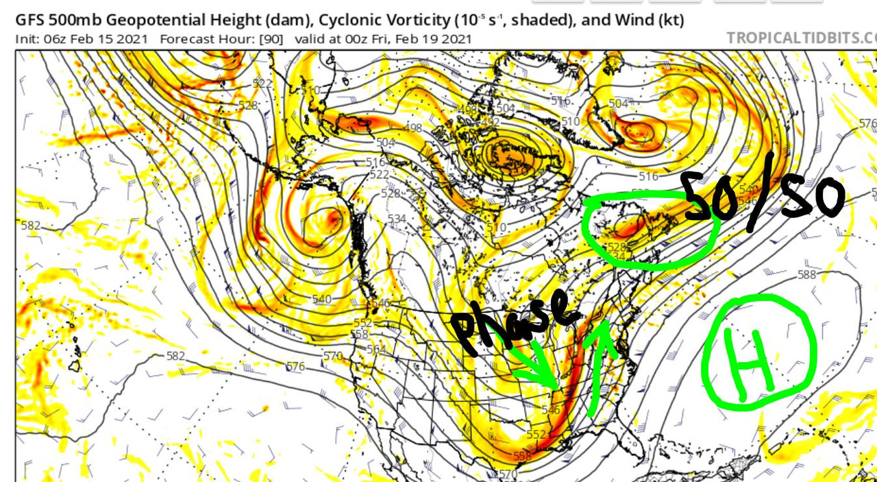
If we look at the Thursday evening time stamp again but this time at the 500mb level, you can see how heights along the east coast are rising ahead of the mid-level trough. Notice how we are on the east side of this trough, and all the PvA (upper level energy denoted by the yellows/oranges) is elongated along the eastern side of the trough. Look at how far south this trough gets. It practically is in the Gulf of Mexico. The problem is, when the upper level energy is elongated like that and not consolidated at the base of the trough, it means at the surface we're seeing early maturation of the low and a path that leads it more north than east. What's working in our favor is the High Pressure I talked about in the last image, and the fact there is a very pseudo-like 50/50 low which you can see I circled on here. The combination of HP and 50/50 low to the north is what's helping our temperatures stay colder a little longer than normal to promote wintry precipitation instead of just plain rain.
Despite a potential transfer to the coast, we're seeing too much activity happening west of here. The dynamics do not really favor our area for this one. That said, I think the front-end 'thump' of snow could be significant for some. I'm talking a nice 4-8" in spots before changing over. Some models are less bullish with the front-end thump and show very minor snowfall. As we go through this week let's keep an eye on the HP, our temperatures and trends that may involve areas N&W of NYC staying all snow, though I doubt it at this moment.
Last edited by Frank_Wx on Tue Feb 16, 2021 7:32 am; edited 1 time in total
_________________
_______________________________________________________________________________________________________
CLICK HERE to view NJ Strong Snowstorm Classifications

Frank_Wx- Godzilla Seeker

- Posts : 21305
Reputation : 328
Join date : 2013-01-05
Age : 31
Location : Jersey City, NJ -

Re: Thursday, 02/18: The Next One
![]() by SENJsnowman Mon Feb 15, 2021 9:55 am
by SENJsnowman Mon Feb 15, 2021 9:55 am


SENJsnowman- Senior Enthusiast

- Posts : 1186
Reputation : 61
Join date : 2017-01-06
Age : 51
Location : Bayville, NJ
Re: Thursday, 02/18: The Next One
![]() by heehaw453 Mon Feb 15, 2021 11:13 am
by heehaw453 Mon Feb 15, 2021 11:13 am
Bottom line is so far so good.
heehaw453- Advanced Forecaster

- Posts : 3906
Reputation : 86
Join date : 2014-01-20
Location : Bedminster Township, PA Elevation 600' ASL
CPcantmeasuresnow likes this post
Re: Thursday, 02/18: The Next One
![]() by Frank_Wx Mon Feb 15, 2021 12:54 pm
by Frank_Wx Mon Feb 15, 2021 12:54 pm
This trend of a slower SE Canada vortex flattens/suppresses the height field over the E US, shifting the track of the next storm later this week SEward w/ a relatively narrower rain-snow transition zone/less ice overall as mid-upper level forcing for descent weakens. https://t.co/rkMKzj8jq8 pic.twitter.com/ntVYmcMLpc
— Eric Webb (@webberweather) February 15, 2021
_________________
_______________________________________________________________________________________________________
CLICK HERE to view NJ Strong Snowstorm Classifications
Frank_Wx- Godzilla Seeker
- Posts : 21305
Reputation : 328
Join date : 2013-01-05
Age : 31
Location : Jersey City, NJ -
CPcantmeasuresnow likes this post
Re: Thursday, 02/18: The Next One
![]() by heehaw453 Mon Feb 15, 2021 1:22 pm
by heehaw453 Mon Feb 15, 2021 1:22 pm
heehaw453- Advanced Forecaster
- Posts : 3906
Reputation : 86
Join date : 2014-01-20
Location : Bedminster Township, PA Elevation 600' ASL
CPcantmeasuresnow likes this post
Re: Thursday, 02/18: The Next One
![]() by SENJsnowman Mon Feb 15, 2021 1:43 pm
by SENJsnowman Mon Feb 15, 2021 1:43 pm
Based on the trends and what all Frank and heehaw have said so far and and just taking the 12z verbatim, I'm wondering if Eastern Nassau and into Suffolk counties are maybe the best spot to stay all snow and still get decent rates?


SENJsnowman- Senior Enthusiast
- Posts : 1186
Reputation : 61
Join date : 2017-01-06
Age : 51
Location : Bayville, NJ
Re: Thursday, 02/18: The Next One
![]() by heehaw453 Mon Feb 15, 2021 1:56 pm
by heehaw453 Mon Feb 15, 2021 1:56 pm
SENJsnowman wrote:What I was just checking is what the SE trend might mean for the change to rain along the coast, and we can see really good trends in that regard. That primary low I don't think is forecast to hit Ohio anymore. Of course, the flip side is that LHV and NEPA in particular see lower totals, but the snowfall distribution on the 12z GFS is quite equitable...lol.
Based on the trends and what all Frank and heehaw have said so far and and just taking the 12z verbatim, I'm wondering if Eastern Nassau and into Suffolk counties are maybe the best spot to stay all snow and still get decent rates?
IMO the 500 mb trough is too far back to prevent this as all snow event for just about everyone in this forum. It's a question of how suppressed the the heights are at this point to keep the mid-level redevelopment as far east as possible. Without those heights being suppressed the 700-800 mb would just flood the area with warmth and taint the snow to IP.
heehaw453- Advanced Forecaster
- Posts : 3906
Reputation : 86
Join date : 2014-01-20
Location : Bedminster Township, PA Elevation 600' ASL
Re: Thursday, 02/18: The Next One
![]() by heehaw453 Mon Feb 15, 2021 2:28 pm
by heehaw453 Mon Feb 15, 2021 2:28 pm
heehaw453- Advanced Forecaster
- Posts : 3906
Reputation : 86
Join date : 2014-01-20
Location : Bedminster Township, PA Elevation 600' ASL
phil155 likes this post
Re: Thursday, 02/18: The Next One
![]() by billg315 Mon Feb 15, 2021 2:57 pm
by billg315 Mon Feb 15, 2021 2:57 pm

billg315- Advanced Forecaster - Mod

- Posts : 4469
Reputation : 185
Join date : 2015-01-24
Age : 50
Location : Flemington, NJ
Re: Thursday, 02/18: The Next One
![]() by amugs Mon Feb 15, 2021 3:52 pm
by amugs Mon Feb 15, 2021 3:52 pm
_________________
Mugs
AKA:King: Snow Weenie
Self Proclaimed
WINTER 2014-15 : 55.12" +.02 for 6 coatings (avg. 35")
WINTER 2015-16 Total - 29.8" (Avg 35")
WINTER 2016-17 : 39.5" so far

amugs- Advanced Forecaster - Mod
- Posts : 15093
Reputation : 213
Join date : 2013-01-07
Age : 54
Location : Hillsdale,NJ
phil155 likes this post
Re: Thursday, 02/18: The Next One
![]() by nutleyblizzard Mon Feb 15, 2021 6:59 pm
by nutleyblizzard Mon Feb 15, 2021 6:59 pm

nutleyblizzard- Senior Enthusiast
- Posts : 1952
Reputation : 41
Join date : 2014-01-30
Age : 58
Location : Nutley, new jersey
Re: Thursday, 02/18: The Next One
![]() by billg315 Mon Feb 15, 2021 7:52 pm
by billg315 Mon Feb 15, 2021 7:52 pm
billg315- Advanced Forecaster - Mod
- Posts : 4469
Reputation : 185
Join date : 2015-01-24
Age : 50
Location : Flemington, NJ
CPcantmeasuresnow likes this post
Re: Thursday, 02/18: The Next One
![]() by jmanley32 Mon Feb 15, 2021 8:07 pm
by jmanley32 Mon Feb 15, 2021 8:07 pm
well lets hope it continues because yet again it introduces prolonged frz for 95 coordidor this time 0.1-0.3 which i would much rather have be snow. to the north looks good and we see several inches. but a quarter inch of ice after snow is not good.nutleyblizzard wrote:18z GFS and RGEM are colder for Thursday’s storm. Starting to get interesting.

jmanley32- Senior Enthusiast
- Posts : 20517
Reputation : 108
Join date : 2013-12-12
Age : 42
Location : Yonkers, NY
phil155 likes this post
Re: Thursday, 02/18: The Next One
![]() by sabamfa Mon Feb 15, 2021 8:15 pm
by sabamfa Mon Feb 15, 2021 8:15 pm
sabamfa- Pro Enthusiast

- Posts : 246
Reputation : 2
Join date : 2013-11-05
Age : 37
Location : Wayne, NJ
Re: Thursday, 02/18: The Next One
![]() by amugs Mon Feb 15, 2021 8:35 pm
by amugs Mon Feb 15, 2021 8:35 pm
Need the HP to be more west and then slide over the top which UT is showing at this time. This storm now we are eating as a cutter BUT it will help set up the Thursday Friday storm. The Banana High is going to keep the colder air in.
We'll see how this looks by 12 Z tomorrow.
Driving conditions were on Friday? NNJ could be rough for the morning hours.
_________________
Mugs
AKA:King: Snow Weenie
Self Proclaimed
WINTER 2014-15 : 55.12" +.02 for 6 coatings (avg. 35")
WINTER 2015-16 Total - 29.8" (Avg 35")
WINTER 2016-17 : 39.5" so far
amugs- Advanced Forecaster - Mod
- Posts : 15093
Reputation : 213
Join date : 2013-01-07
Age : 54
Location : Hillsdale,NJ
sabamfa and jmanley32 like this post
Re: Thursday, 02/18: The Next One
![]() by jmanley32 Mon Feb 15, 2021 11:45 pm
by jmanley32 Mon Feb 15, 2021 11:45 pm
jmanley32- Senior Enthusiast
- Posts : 20517
Reputation : 108
Join date : 2013-12-12
Age : 42
Location : Yonkers, NY
Re: Thursday, 02/18: The Next One
![]() by SNOW MAN Tue Feb 16, 2021 5:08 am
by SNOW MAN Tue Feb 16, 2021 5:08 am

SNOW MAN- Senior Enthusiast
- Posts : 1361
Reputation : 25
Join date : 2013-01-13
Age : 64
Location : Marshalls Creek Pa.
CPcantmeasuresnow and essexcountypete like this post
Re: Thursday, 02/18: The Next One
![]() by heehaw453 Tue Feb 16, 2021 5:10 am
by heehaw453 Tue Feb 16, 2021 5:10 am
I guess what I'm try to say is significant snow is looking much more likely with this system. It has not taken steps in the wrong direction synoptically whatsoever.
heehaw453- Advanced Forecaster
- Posts : 3906
Reputation : 86
Join date : 2014-01-20
Location : Bedminster Township, PA Elevation 600' ASL
CPcantmeasuresnow and weatherwatchermom like this post
Re: Thursday, 02/18: The Next One
![]() by heehaw453 Tue Feb 16, 2021 5:23 am
by heehaw453 Tue Feb 16, 2021 5:23 am
heehaw453- Advanced Forecaster
- Posts : 3906
Reputation : 86
Join date : 2014-01-20
Location : Bedminster Township, PA Elevation 600' ASL
CPcantmeasuresnow and phil155 like this post
Re: Thursday, 02/18: The Next One
![]() by heehaw453 Tue Feb 16, 2021 5:34 am
by heehaw453 Tue Feb 16, 2021 5:34 am
heehaw453- Advanced Forecaster
- Posts : 3906
Reputation : 86
Join date : 2014-01-20
Location : Bedminster Township, PA Elevation 600' ASL
CPcantmeasuresnow likes this post
Re: Thursday, 02/18: The Next One
![]() by Frank_Wx Tue Feb 16, 2021 7:36 am
by Frank_Wx Tue Feb 16, 2021 7:36 am
heehaw453 wrote:If you look at the 500 mb trough (how far west it is) you'd never think this could have a legit chance of being mostly snow (NW-I95), but it's that vigorous ULL (lowering heights) passing through Quebec in conjunction with 50/50 low (pinning the High) that makes it plausible. Unreal.
Yup exactly.
5 consecutive runs of the GFS de amplifying heights because the ULL keeps trending slower
_________________
_______________________________________________________________________________________________________
CLICK HERE to view NJ Strong Snowstorm Classifications
Frank_Wx- Godzilla Seeker
- Posts : 21305
Reputation : 328
Join date : 2013-01-05
Age : 31
Location : Jersey City, NJ -
CPcantmeasuresnow likes this post
Re: Thursday, 02/18: The Next One
![]() by SENJsnowman Tue Feb 16, 2021 8:33 am
by SENJsnowman Tue Feb 16, 2021 8:33 am
SENJsnowman- Senior Enthusiast
- Posts : 1186
Reputation : 61
Join date : 2017-01-06
Age : 51
Location : Bayville, NJ
Re: Thursday, 02/18: The Next One
![]() by Frank_Wx Tue Feb 16, 2021 8:50 am
by Frank_Wx Tue Feb 16, 2021 8:50 am
SENJsnowman wrote:Aside from loving the actual substance of the discussion, I LOVE the subtle yet profound changes to the language in your scroll and thread title Frank! If I knew Italian, I'd hit you up with a nice little phrase here to show my appreciation. lol
Haha
I'm still thinking NYC and south sees a front-end thump before a changeover, but now I'm thinking N&W may stay all frozen...
_________________
_______________________________________________________________________________________________________
CLICK HERE to view NJ Strong Snowstorm Classifications
Frank_Wx- Godzilla Seeker
- Posts : 21305
Reputation : 328
Join date : 2013-01-05
Age : 31
Location : Jersey City, NJ -
Re: Thursday, 02/18: The Next One
![]() by jmanley32 Tue Feb 16, 2021 9:03 am
by jmanley32 Tue Feb 16, 2021 9:03 am
so there will be a sharp cutoff at NYC or are you talking far nw of NYC. Still like to wake to nice scroll but is there any chance us coastal areas stay snow? When you say i95 for nj it goes north to south but when ur talking NY 95 goes super close to NYC in face it crosses in the Bronx I believe. So it's kinda confusing when you say NW of i95 in terms of how far.Frank_Wx wrote:SENJsnowman wrote:Aside from loving the actual substance of the discussion, I LOVE the subtle yet profound changes to the language in your scroll and thread title Frank! If I knew Italian, I'd hit you up with a nice little phrase here to show my appreciation. lol
Haha
I'm still thinking NYC and south sees a front-end thump before a changeover, but now I'm thinking N&W may stay all frozen...
jmanley32- Senior Enthusiast
- Posts : 20517
Reputation : 108
Join date : 2013-12-12
Age : 42
Location : Yonkers, NY
Re: Thursday, 02/18: The Next One
![]() by heehaw453 Tue Feb 16, 2021 9:20 am
by heehaw453 Tue Feb 16, 2021 9:20 am

heehaw453- Advanced Forecaster
- Posts : 3906
Reputation : 86
Join date : 2014-01-20
Location : Bedminster Township, PA Elevation 600' ASL
CPcantmeasuresnow and SNOW MAN like this post
Page 1 of 5 • 1, 2, 3, 4, 5 ![]()