
 Search
Tracking JAN 29th 2022 'The Phase'
Page 16 of 31 •  1 ... 9 ... 15, 16, 17 ... 23 ... 31
 ![]()
Re: Tracking JAN 29th 2022 'The Phase'
![]() by heehaw453 Wed Jan 26, 2022 11:22 pm
by heehaw453 Wed Jan 26, 2022 11:22 pm
nutleyblizzard wrote:UKIE and JMA way west!
JMA was sweet.
heehaw453- Advanced Forecaster

- Posts : 3906
Join date : 2014-01-20
Re: Tracking JAN 29th 2022 'The Phase'
![]() by Frank_Wx Wed Jan 26, 2022 11:27 pm
by Frank_Wx Wed Jan 26, 2022 11:27 pm
Frank_Wx- Godzilla Seeker

- Posts : 21305
Join date : 2013-01-05 -

Re: Tracking JAN 29th 2022 'The Phase'
![]() by Frank_Wx Wed Jan 26, 2022 11:27 pm
by Frank_Wx Wed Jan 26, 2022 11:27 pm
Artechmetals wrote:Hey Frank do we have a better chance at a foot of snow out of this system area wide or Mario Balotelli scoring a goal for Italy in the World Cup playoff in marchFrank_Wx wrote:

Definitely a Balo gooooalasooo
_________________
_______________________________________________________________________________________________________
CLICK HERE to view NJ Strong Snowstorm Classifications

Frank_Wx- Godzilla Seeker
- Posts : 21305
Reputation : 328
Join date : 2013-01-05
Age : 31
Location : Jersey City, NJ -
Re: Tracking JAN 29th 2022 'The Phase'
![]() by Frank_Wx Wed Jan 26, 2022 11:30 pm
by Frank_Wx Wed Jan 26, 2022 11:30 pm


_________________
_______________________________________________________________________________________________________
CLICK HERE to view NJ Strong Snowstorm Classifications
Frank_Wx- Godzilla Seeker
- Posts : 21305
Reputation : 328
Join date : 2013-01-05
Age : 31
Location : Jersey City, NJ -
Re: Tracking JAN 29th 2022 'The Phase'
![]() by Frank_Wx Wed Jan 26, 2022 11:32 pm
by Frank_Wx Wed Jan 26, 2022 11:32 pm

_________________
_______________________________________________________________________________________________________
CLICK HERE to view NJ Strong Snowstorm Classifications
Frank_Wx- Godzilla Seeker
- Posts : 21305
Reputation : 328
Join date : 2013-01-05
Age : 31
Location : Jersey City, NJ -
jmanley32 likes this post
Re: Tracking JAN 29th 2022 'The Phase'
![]() by Frank_Wx Wed Jan 26, 2022 11:41 pm
by Frank_Wx Wed Jan 26, 2022 11:41 pm

_________________
_______________________________________________________________________________________________________
CLICK HERE to view NJ Strong Snowstorm Classifications
Frank_Wx- Godzilla Seeker
- Posts : 21305
Reputation : 328
Join date : 2013-01-05
Age : 31
Location : Jersey City, NJ -
Re: Tracking JAN 29th 2022 'The Phase'
![]() by Frank_Wx Wed Jan 26, 2022 11:42 pm
by Frank_Wx Wed Jan 26, 2022 11:42 pm

_________________
_______________________________________________________________________________________________________
CLICK HERE to view NJ Strong Snowstorm Classifications
Frank_Wx- Godzilla Seeker
- Posts : 21305
Reputation : 328
Join date : 2013-01-05
Age : 31
Location : Jersey City, NJ -
Re: Tracking JAN 29th 2022 'The Phase'
![]() by heehaw453 Wed Jan 26, 2022 11:46 pm
by heehaw453 Wed Jan 26, 2022 11:46 pm
Frank_Wx wrote:If CMC closed H5 3-6 hours earlier it’s a Godzilla for many many more
Yeah. Whatever is occurring is not done. There will be more corrections. I think part 1 is phase which models are starting to latch on now, part two is what happens to the mid-level/surface storm as it consolidates. Does is capture with ULL, does ULL close off earlier. Plenty of drama left.
heehaw453- Advanced Forecaster
- Posts : 3906
Reputation : 86
Join date : 2014-01-20
Location : Bedminster Township, PA Elevation 600' ASL
weatherwatchermom likes this post
Re: Tracking JAN 29th 2022 'The Phase'
![]() by Zhukov1945 Wed Jan 26, 2022 11:47 pm
by Zhukov1945 Wed Jan 26, 2022 11:47 pm
Frank_Wx wrote:If CMC closed H5 3-6 hours earlier it’s a Godzilla for many many more
Very dumb question that is now relevant given all the discussion - what does it mean for a ULL to "close"?

Zhukov1945- Posts : 138
Reputation : 8
Join date : 2018-03-21
Location : Clinton Township NJ
weatherwatchermom likes this post
Re: Tracking JAN 29th 2022 'The Phase'
![]() by Frank_Wx Wed Jan 26, 2022 11:48 pm
by Frank_Wx Wed Jan 26, 2022 11:48 pm

_________________
_______________________________________________________________________________________________________
CLICK HERE to view NJ Strong Snowstorm Classifications
Frank_Wx- Godzilla Seeker
- Posts : 21305
Reputation : 328
Join date : 2013-01-05
Age : 31
Location : Jersey City, NJ -
Re: Tracking JAN 29th 2022 'The Phase'
![]() by heehaw453 Wed Jan 26, 2022 11:49 pm
by heehaw453 Wed Jan 26, 2022 11:49 pm
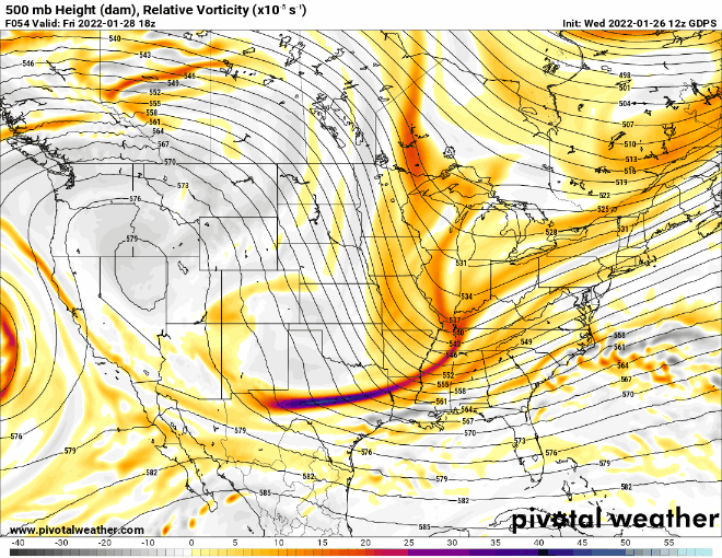
Frank_Wx wrote:UKIE, which has been out to sea for days, now shows this. MADONNE!!!!!
Miller A storm all the way up the coast here.
heehaw453- Advanced Forecaster
- Posts : 3906
Reputation : 86
Join date : 2014-01-20
Location : Bedminster Township, PA Elevation 600' ASL
CPcantmeasuresnow and Bwtr like this post
Re: Tracking JAN 29th 2022 'The Phase'
![]() by Frank_Wx Wed Jan 26, 2022 11:55 pm
by Frank_Wx Wed Jan 26, 2022 11:55 pm
Zhukov1945 wrote:Frank_Wx wrote:If CMC closed H5 3-6 hours earlier it’s a Godzilla for many many more
Very dumb question that is now relevant given all the discussion - what does it mean for a ULL to "close"?
Look at the contours. When they form a circle in the center (like this does south east of NYC) it’s considered to be a closed low. Meaning, it’s no longer an open wave in the overall flow of the atmosphere. Air is now moving in circles around this low, thus promoting rapid intensification of our main low pressure and dictating its eventual track.
_________________
_______________________________________________________________________________________________________
CLICK HERE to view NJ Strong Snowstorm Classifications
Frank_Wx- Godzilla Seeker
- Posts : 21305
Reputation : 328
Join date : 2013-01-05
Age : 31
Location : Jersey City, NJ -
CPcantmeasuresnow, Taffy, brownie, essexcountypete, weatherwatchermom, SENJsnowman, Zhukov1945 and like this post
Re: Tracking JAN 29th 2022 'The Phase'
![]() by weatherwatchermom Thu Jan 27, 2022 1:03 am
by weatherwatchermom Thu Jan 27, 2022 1:03 am

weatherwatchermom- Senior Enthusiast

- Posts : 3750
Reputation : 77
Join date : 2014-11-25
Age : 60
Location : Hazlet Township, NJ
Re: Tracking JAN 29th 2022 'The Phase'
![]() by CPcantmeasuresnow Thu Jan 27, 2022 1:08 am
by CPcantmeasuresnow Thu Jan 27, 2022 1:08 am

CPcantmeasuresnow- Wx Statistician Guru

- Posts : 7274
Reputation : 230
Join date : 2013-01-07
Age : 103
Location : Eastern Orange County, NY
weatherwatchermom likes this post
Re: Tracking JAN 29th 2022 'The Phase'
![]() by CPcantmeasuresnow Thu Jan 27, 2022 1:18 am
by CPcantmeasuresnow Thu Jan 27, 2022 1:18 am
Weird night again but overall positive. Still unsure what to think. Definitely north and west back in play for a decent hit and city on east for a major hit. Of course we still have the GFS basically giving everyone the shaft. My head is spinning. Need sleep but it ain’t happening.
CPcantmeasuresnow- Wx Statistician Guru
- Posts : 7274
Reputation : 230
Join date : 2013-01-07
Age : 103
Location : Eastern Orange County, NY
weatherwatchermom likes this post
Re: Tracking JAN 29th 2022 'The Phase'
![]() by hyde345 Thu Jan 27, 2022 1:35 am
by hyde345 Thu Jan 27, 2022 1:35 am
CPcantmeasuresnow wrote:Euro slightly east of last run. Not what we wanted but not horrible either. LI and east still do okay north and west not so much. It could have been a very good night if Euro came west but of course not in the cards as this setup continues to confuse and waiver.
Weird night again but overall positive. Still unsure what to think. Definitely north and west back in play for a decent hit and city on east for a major hit. Of course we still have the GFS basically giving everyone the shaft. My head is spinning. Need sleep but it ain’t happening.
Disappointing run for us N and W guys after the west trend from most other models. 4th straight run the Euro has decreased my qpf. Any more and I will be sucking virga which is still a possibility I suppose. Lets hope for continued westward shift tomorrow.

hyde345- Pro Enthusiast

- Posts : 1082
Reputation : 48
Join date : 2013-01-08
Location : Hyde Park, NY
Re: Tracking JAN 29th 2022 'The Phase'
![]() by SoulSingMG Thu Jan 27, 2022 3:47 am
by SoulSingMG Thu Jan 27, 2022 3:47 am
Northern Fairfield-Northern New Haven-Northern Middlesex-Northern New London-Southern Fairfield-Southern New Haven-Southern Middlesex-Southern New London-Hudson-Northern Westchester-Southern Westchester-New York (Manhattan)-Bronx-Richmond (Staten Island)-Kings (Brooklyn)-Northwest Suffolk-Northeast Suffolk-Southwest Suffolk-Southeast Suffolk-Northern Queens-Northern Nassau-Southern Queens-Southern Nassau-
340 AM EST Thu Jan 27 2022
...WINTER STORM WATCH IN EFFECT FROM FRIDAY EVENING THROUGH SATURDAY EVENING...
Winter Storm Watch.
There is potential for a low pressure storm system to bring 6-12" of heavy snowfall and high winds to the area Friday night into Saturday night. Minor to locally moderate coastal impacts are also possible for eastern portions of Long Island and vulnerable north facing coastal communities along Long Island Sound and the Great South Bay for the Saturday into Sunday high tides.

SoulSingMG- Senior Enthusiast
- Posts : 2853
Reputation : 74
Join date : 2013-12-11
Location : Long Island City, NY
mmanisca and weatherwatchermom like this post
Re: Tracking JAN 29th 2022 'The Phase'
![]() by mmanisca Thu Jan 27, 2022 3:53 am
by mmanisca Thu Jan 27, 2022 3:53 am

mmanisca- Pro Enthusiast
- Posts : 299
Reputation : 3
Join date : 2013-01-23
Age : 65
Location : Deer Park, Long Island
Re: Tracking JAN 29th 2022 'The Phase'
![]() by jmanley32 Thu Jan 27, 2022 4:04 am
by jmanley32 Thu Jan 27, 2022 4:04 am

jmanley32- Senior Enthusiast
- Posts : 20517
Reputation : 108
Join date : 2013-12-12
Age : 42
Location : Yonkers, NY
Re: Tracking JAN 29th 2022 'The Phase'
![]() by SENJsnowman Thu Jan 27, 2022 4:36 am
by SENJsnowman Thu Jan 27, 2022 4:36 am
Still so much work for the coast to do here, but it's Thursday morning...and the hunt continues!

SENJsnowman- Senior Enthusiast
- Posts : 1186
Reputation : 61
Join date : 2017-01-06
Age : 51
Location : Bayville, NJ
Re: Tracking JAN 29th 2022 'The Phase'
![]() by Sanchize06 Thu Jan 27, 2022 4:42 am
by Sanchize06 Thu Jan 27, 2022 4:42 am
Sanchize06- Senior Enthusiast
- Posts : 1041
Reputation : 21
Join date : 2013-02-05
Location : Union Beach, NJ
Re: Tracking JAN 29th 2022 'The Phase'
![]() by Sanchize06 Thu Jan 27, 2022 4:51 am
by Sanchize06 Thu Jan 27, 2022 4:51 am

Sanchize06- Senior Enthusiast
- Posts : 1041
Reputation : 21
Join date : 2013-02-05
Location : Union Beach, NJ

skinsfan1177- Senior Enthusiast
- Posts : 4485
Reputation : 35
Join date : 2013-01-07
Age : 46
Location : Point Pleasant Boro
Re: Tracking JAN 29th 2022 'The Phase'
![]() by skinsfan1177 Thu Jan 27, 2022 4:52 am
by skinsfan1177 Thu Jan 27, 2022 4:52 am
skinsfan1177- Senior Enthusiast
- Posts : 4485
Reputation : 35
Join date : 2013-01-07
Age : 46
Location : Point Pleasant Boro
Sanchize06 likes this post

skinsfan1177- Senior Enthusiast
- Posts : 4485
Reputation : 35
Join date : 2013-01-07
Age : 46
Location : Point Pleasant Boro
Sanchize06 likes this post
Re: Tracking JAN 29th 2022 'The Phase'
![]() by Sanchize06 Thu Jan 27, 2022 4:59 am
by Sanchize06 Thu Jan 27, 2022 4:59 am
Sanchize06- Senior Enthusiast
- Posts : 1041
Reputation : 21
Join date : 2013-02-05
Location : Union Beach, NJ
Re: Tracking JAN 29th 2022 'The Phase'
![]() by skinsfan1177 Thu Jan 27, 2022 5:05 am
by skinsfan1177 Thu Jan 27, 2022 5:05 am
Sanchize06 wrote:Nice improvements on the 6z GFS as well with the s/w energy and phasing, though still remains east of everything else. The improvements at 500mb is really all you need to see from the GFS as it probably won't catch on until he end lol
Agree the Gfs closes off later than other guidance. 3 hours sooner would be great. But got ylto admit the trends are good
skinsfan1177- Senior Enthusiast
- Posts : 4485
Reputation : 35
Join date : 2013-01-07
Age : 46
Location : Point Pleasant Boro
Sanchize06 likes this post
Page 16 of 31 • 1 ... 9 ... 15, 16, 17 ... 23 ... 31 ![]()
|
|
|