
 Search
2023 Atlantic Tropics season
Page 11 of 20 •  1 ... 7 ... 10, 11, 12 ... 15 ... 20
 ![]()
Re: 2023 Atlantic Tropics season
![]() by jmanley32 Fri Sep 08, 2023 10:18 am
by jmanley32 Fri Sep 08, 2023 10:18 am
There have been runs right over the cape Frank, go back and catch up more lol. Ray still believes he is a big threat to the US east coast, or at least he hasn't changed his stance yet. How you been? Wondered where you have been.Frank_Wx wrote:Alright, this is too close for comfort

jmanley32- Senior Enthusiast

- Posts : 20517
Join date : 2013-12-12
rb924119 likes this post
Re: 2023 Atlantic Tropics season
![]() by phil155 Fri Sep 08, 2023 10:24 am
by phil155 Fri Sep 08, 2023 10:24 am
phil155- Pro Enthusiast

- Posts : 475
Join date : 2019-12-16
docstox12, rb924119 and weatherwatchermom like this post
Re: 2023 Atlantic Tropics season
![]() by sroc4 Fri Sep 08, 2023 11:18 am
by sroc4 Fri Sep 08, 2023 11:18 am
phil155 wrote:The overall structure of the storm does not look as good as it did earlier. It almost looks to my again very novice eyes like there is some sheer or dry air impacting the east and south east portion of the system. Again just my novice observation
it does look like there is a little shear for sure. Great observation!
_________________
"In weather and in life, there's no winning and losing; there's only winning and learning."
WINTER 2012/2013 TOTALS 43.65"WINTER 2017/2018 TOTALS 62.85" WINTER 2022/2023 TOTALS 4.9"
WINTER 2013/2014 TOTALS 64.85"WINTER 2018/2019 TOTALS 14.25" WINTER 2023/2024 TOTALS 13.1"
WINTER 2014/2015 TOTALS 71.20"WINTER 2019/2020 TOTALS 6.35"
WINTER 2015/2016 TOTALS 35.00"WINTER 2020/2021 TOTALS 37.75"
WINTER 2016/2017 TOTALS 42.25"WINTER 2021/2022 TOTALS 31.65"

sroc4- Admin

- Posts : 8331
Reputation : 301
Join date : 2013-01-07
Location : Wading River, LI
rb924119 and phil155 like this post
Re: 2023 Atlantic Tropics season
![]() by Frank_Wx Fri Sep 08, 2023 11:58 am
by Frank_Wx Fri Sep 08, 2023 11:58 am
phil155 wrote:The overall structure of the storm does not look as good as it did earlier. It almost looks to my again very novice eyes like there is some sheer or dry air impacting the east and south east portion of the system. Again just my novice observation
You are correct. Looks like around 65W conditions turn favorable again.

_________________
_______________________________________________________________________________________________________
CLICK HERE to view NJ Strong Snowstorm Classifications

Frank_Wx- Godzilla Seeker
- Posts : 21305
Reputation : 328
Join date : 2013-01-05
Age : 31
Location : Jersey City, NJ -

rb924119 likes this post
Re: 2023 Atlantic Tropics season
![]() by amugs Fri Sep 08, 2023 12:34 pm
by amugs Fri Sep 08, 2023 12:34 pm
_________________
Mugs
AKA:King: Snow Weenie
Self Proclaimed
WINTER 2014-15 : 55.12" +.02 for 6 coatings (avg. 35")
WINTER 2015-16 Total - 29.8" (Avg 35")
WINTER 2016-17 : 39.5" so far

amugs- Advanced Forecaster - Mod

- Posts : 15093
Reputation : 213
Join date : 2013-01-07
Age : 54
Location : Hillsdale,NJ
rb924119 and weatherwatchermom like this post
Re: 2023 Atlantic Tropics season
![]() by sroc4 Fri Sep 08, 2023 12:51 pm
by sroc4 Fri Sep 08, 2023 12:51 pm
Frank_Wx wrote:phil155 wrote:The overall structure of the storm does not look as good as it did earlier. It almost looks to my again very novice eyes like there is some sheer or dry air impacting the east and south east portion of the system. Again just my novice observation
You are correct. Looks like around 65W conditions turn favorable again.
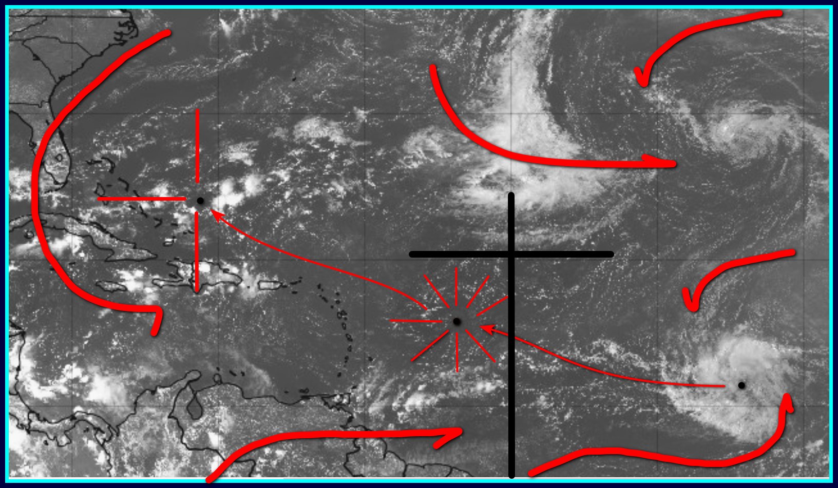
In the Hi-res loop you can see the cloud tops being blown off in areas I have circled in yellow from SW to NNE direction, indicating some shear.
https://www.tropicaltidbits.com/sat/satlooper.php?region=13L&product=vis

_________________
"In weather and in life, there's no winning and losing; there's only winning and learning."
WINTER 2012/2013 TOTALS 43.65"WINTER 2017/2018 TOTALS 62.85" WINTER 2022/2023 TOTALS 4.9"
WINTER 2013/2014 TOTALS 64.85"WINTER 2018/2019 TOTALS 14.25" WINTER 2023/2024 TOTALS 13.1"
WINTER 2014/2015 TOTALS 71.20"WINTER 2019/2020 TOTALS 6.35"
WINTER 2015/2016 TOTALS 35.00"WINTER 2020/2021 TOTALS 37.75"
WINTER 2016/2017 TOTALS 42.25"WINTER 2021/2022 TOTALS 31.65"
sroc4- Admin
- Posts : 8331
Reputation : 301
Join date : 2013-01-07
Location : Wading River, LI
rb924119 likes this post
Re: 2023 Atlantic Tropics season
![]() by GreyBeard Fri Sep 08, 2023 1:30 pm
by GreyBeard Fri Sep 08, 2023 1:30 pm
https://www.accuweather.com/en/hurricane/hurricane-lee-a-monster-hurricane-as-accuweather-forecasters-up-risk-of-us-impacts/1577689
GreyBeard- Senior Enthusiast
- Posts : 725
Reputation : 34
Join date : 2014-02-12
Location : eastern nassau county
rb924119 likes this post
Re: 2023 Atlantic Tropics season
![]() by jmanley32 Fri Sep 08, 2023 1:45 pm
by jmanley32 Fri Sep 08, 2023 1:45 pm
straight forward no hype, just facts, but we all need to watch closely, as it states a landfall even in cape cod or maine would bring pretty sig wind and rain impacts into NYC and CT and maybe NJ depending on how much he expands, further east as stated and atlantic canada and far eastern NE will feel the brunt. I still think this threat map changes a number of times through next week, glad to see he won't be coming as quickly and maybe I can get my trip eastern CT in before anything happens should he pose a threat.GreyBeard wrote:From what I have been reading, there are two main players that will determine the track.The position and strength of the Bermuda high and the position of the jet stream. Good article explaining this.
https://www.accuweather.com/en/hurricane/hurricane-lee-a-monster-hurricane-as-accuweather-forecasters-up-risk-of-us-impacts/1577689

jmanley32- Senior Enthusiast
- Posts : 20517
Reputation : 108
Join date : 2013-12-12
Age : 42
Location : Yonkers, NY
rb924119 and GreyBeard like this post
Re: 2023 Atlantic Tropics season
![]() by sroc4 Fri Sep 08, 2023 1:49 pm
by sroc4 Fri Sep 08, 2023 1:49 pm
GreyBeard wrote:From what I have been reading, there are two main players that will determine the track.The position and strength of the Bermuda high and the position of the jet stream. Good article explaining this.
https://www.accuweather.com/en/hurricane/hurricane-lee-a-monster-hurricane-as-accuweather-forecasters-up-risk-of-us-impacts/1577689
Good article, but it Sounds familiar
From Monday
sroc4 wrote:jmanley32 wrote:All the major models have the storm currently proged to develop heading towards the EC, GFS going into fantasy land above has a strong can skirt the coast and turn away uncomfortably close. Still way out past 10 days and we know that means nothing but Rb as stated above seems to feel the pattern might warrant a watchful eye for our area in about 10-12 days. Euro develops the system far slower and it's movement than CMC and GFS. Will be interesting to watch, impacts or not. Rb waiting on that analysis, of course it's the holiday don't expect it now. Hope everyone is enjoying.
Here is some analysis to show you why the GFS is doing what it's doing vs why the Euro is doing what it's doing. I don't care how consistent a model is showing a surface feature scraping or hitting the coast, its vital to focus on big picture, not surface maps at all, ideas. Big picture means do not look at anything below 500mb(Altitude) in the atmosphere if you are trying to get an idea if its even possible for this system to threaten the EC.
There will be multiple factors and details to analyze if we get under 3-5days, but In order for this system to even get close IT MUST "miss the first long wave trough(LWTrough)". If it doesn't it WILL recurve. At this lead time, this is point number 1.
Below compare GFS vs Euro. As we approach the time frame of Sept 10th-12th the system will be passing by the Lesser and Greater Antilles. At this time there will be a mean long wave trough somewhere along the EC. You can clearly see the depth, sharpness, and tilt to the trough varies greatly between the two models. Also look on the left side of the images ie: central CONUS. As the first trough lifts out there is the next one waiting to the west.
Back to the first point, Longwave trough along he EC, GFS lifts this up and out much faster which allows the system to escape its progressive flow. Once underneath the mean flow the GFS has the second trough, combined with a stronger Atlantic ridge nose north, to dig into the east coast capturing the system which steers it towards the coast.
Euro on the other hand, does not lift the first trough out quite as fast and is even more progressive that the GFS which imparts way more influence on the system for longer causing it to begin the recurve by the end of its run. The second trough on the Euro is a series of independent short waves, so its weaker as it makes its way east. Even if the system were to break off the mean flow of the first LW trough and it were to get captured by the second , it would be way too far east to bring it close enough to threaten the coast.


_________________
"In weather and in life, there's no winning and losing; there's only winning and learning."
WINTER 2012/2013 TOTALS 43.65"WINTER 2017/2018 TOTALS 62.85" WINTER 2022/2023 TOTALS 4.9"
WINTER 2013/2014 TOTALS 64.85"WINTER 2018/2019 TOTALS 14.25" WINTER 2023/2024 TOTALS 13.1"
WINTER 2014/2015 TOTALS 71.20"WINTER 2019/2020 TOTALS 6.35"
WINTER 2015/2016 TOTALS 35.00"WINTER 2020/2021 TOTALS 37.75"
WINTER 2016/2017 TOTALS 42.25"WINTER 2021/2022 TOTALS 31.65"
sroc4- Admin
- Posts : 8331
Reputation : 301
Join date : 2013-01-07
Location : Wading River, LI
rb924119 and GreyBeard like this post
Re: 2023 Atlantic Tropics season
![]() by GreyBeard Fri Sep 08, 2023 2:19 pm
by GreyBeard Fri Sep 08, 2023 2:19 pm
sroc4 wrote:GreyBeard wrote:From what I have been reading, there are two main players that will determine the track.The position and strength of the Bermuda high and the position of the jet stream. Good article explaining this.
https://www.accuweather.com/en/hurricane/hurricane-lee-a-monster-hurricane-as-accuweather-forecasters-up-risk-of-us-impacts/1577689
Good article, but it Sounds familiar

No offense meant, but they put in in terms that weren't as technical as your analysis which made it easier for me to understand.
GreyBeard- Senior Enthusiast
- Posts : 725
Reputation : 34
Join date : 2014-02-12
Location : eastern nassau county
rb924119 and weatherwatchermom like this post
Re: 2023 Atlantic Tropics season
![]() by sroc4 Fri Sep 08, 2023 3:05 pm
by sroc4 Fri Sep 08, 2023 3:05 pm
GreyBeard wrote:sroc4 wrote:GreyBeard wrote:From what I have been reading, there are two main players that will determine the track.The position and strength of the Bermuda high and the position of the jet stream. Good article explaining this.
https://www.accuweather.com/en/hurricane/hurricane-lee-a-monster-hurricane-as-accuweather-forecasters-up-risk-of-us-impacts/1577689
Good article, but it Sounds familiar
No offense meant, but they put in in terms that weren't as technical as your analysis which made it easier for me to understand.
None taken at all Greybeard. I know my post maybe sounded a bit arrogant, but its nice sometimes to feel validated when the professionals agree with your thoughts...esp as a mere weather enthusiast without the credentials.
_________________
"In weather and in life, there's no winning and losing; there's only winning and learning."
WINTER 2012/2013 TOTALS 43.65"WINTER 2017/2018 TOTALS 62.85" WINTER 2022/2023 TOTALS 4.9"
WINTER 2013/2014 TOTALS 64.85"WINTER 2018/2019 TOTALS 14.25" WINTER 2023/2024 TOTALS 13.1"
WINTER 2014/2015 TOTALS 71.20"WINTER 2019/2020 TOTALS 6.35"
WINTER 2015/2016 TOTALS 35.00"WINTER 2020/2021 TOTALS 37.75"
WINTER 2016/2017 TOTALS 42.25"WINTER 2021/2022 TOTALS 31.65"
sroc4- Admin
- Posts : 8331
Reputation : 301
Join date : 2013-01-07
Location : Wading River, LI
rb924119, GreyBeard, weatherwatchermom and Zhukov1945 like this post
Re: 2023 Atlantic Tropics season
![]() by jmanley32 Fri Sep 08, 2023 3:49 pm
by jmanley32 Fri Sep 08, 2023 3:49 pm
jmanley32- Senior Enthusiast
- Posts : 20517
Reputation : 108
Join date : 2013-12-12
Age : 42
Location : Yonkers, NY
Re: 2023 Atlantic Tropics season
![]() by jmanley32 Fri Sep 08, 2023 3:50 pm
by jmanley32 Fri Sep 08, 2023 3:50 pm
I read this over quickly so when should we know what that trough is going to do (stronger/weaker) as shown.GreyBeard wrote:sroc4 wrote:GreyBeard wrote:From what I have been reading, there are two main players that will determine the track.The position and strength of the Bermuda high and the position of the jet stream. Good article explaining this.
https://www.accuweather.com/en/hurricane/hurricane-lee-a-monster-hurricane-as-accuweather-forecasters-up-risk-of-us-impacts/1577689
Good article, but it Sounds familiar
No offense meant, but they put in in terms that weren't as technical as your analysis which made it easier for me to understand.
jmanley32- Senior Enthusiast
- Posts : 20517
Reputation : 108
Join date : 2013-12-12
Age : 42
Location : Yonkers, NY
Re: 2023 Atlantic Tropics season
![]() by jmanley32 Fri Sep 08, 2023 3:54 pm
by jmanley32 Fri Sep 08, 2023 3:54 pm
jmanley32- Senior Enthusiast
- Posts : 20517
Reputation : 108
Join date : 2013-12-12
Age : 42
Location : Yonkers, NY
Re: 2023 Atlantic Tropics season
![]() by jmanley32 Fri Sep 08, 2023 5:32 pm
by jmanley32 Fri Sep 08, 2023 5:32 pm
jmanley32- Senior Enthusiast
- Posts : 20517
Reputation : 108
Join date : 2013-12-12
Age : 42
Location : Yonkers, NY
rb924119 likes this post
Re: 2023 Atlantic Tropics season
![]() by amugs Fri Sep 08, 2023 5:41 pm
by amugs Fri Sep 08, 2023 5:41 pm
12z ECMWF has made a rather 'big' adjustment south and is stronger than last run..interesting noteworthy trend.. pic.twitter.com/8NWedMRS7m
— Weather Reboot (@wxreboot) September 8, 2023
_________________
Mugs
AKA:King: Snow Weenie
Self Proclaimed
WINTER 2014-15 : 55.12" +.02 for 6 coatings (avg. 35")
WINTER 2015-16 Total - 29.8" (Avg 35")
WINTER 2016-17 : 39.5" so far
amugs- Advanced Forecaster - Mod
- Posts : 15093
Reputation : 213
Join date : 2013-01-07
Age : 54
Location : Hillsdale,NJ
rb924119 likes this post
Re: 2023 Atlantic Tropics season
![]() by jmanley32 Fri Sep 08, 2023 5:57 pm
by jmanley32 Fri Sep 08, 2023 5:57 pm
What are the implications of this? What I said above?amugs wrote:12z ECMWF has made a rather 'big' adjustment south and is stronger than last run..interesting noteworthy trend.. pic.twitter.com/8NWedMRS7m
— Weather Reboot (@wxreboot) September 8, 2023
jmanley32- Senior Enthusiast
- Posts : 20517
Reputation : 108
Join date : 2013-12-12
Age : 42
Location : Yonkers, NY
jmanley32- Senior Enthusiast
- Posts : 20517
Reputation : 108
Join date : 2013-12-12
Age : 42
Location : Yonkers, NY
Re: 2023 Atlantic Tropics season
![]() by amugs Fri Sep 08, 2023 9:45 pm
by amugs Fri Sep 08, 2023 9:45 pm

Latest GEFS make a shift west with a few more members.

amugs- Advanced Forecaster - Mod
- Posts : 15093
Reputation : 213
Join date : 2013-01-07
Age : 54
Location : Hillsdale,NJ
rb924119 likes this post
Re: 2023 Atlantic Tropics season
![]() by jmanley32 Fri Sep 08, 2023 10:52 pm
by jmanley32 Fri Sep 08, 2023 10:52 pm
Well damn jeeze, the run actuall curves back NNW as it heads north, interesting. I will be in eastern CT at that time (nearly RI), well headed back here, will be a fun drive....if that happens. One thing that is apparent the windfield is going to be nearly as big as Sandy's was by looks of it and equal on both sides, likely losing some tropical charecteristics as they usually do, but this looks verbatim like a cat 2/3. So you won't need to be anywhere near the center to get strong winds and rain. I cannot believe how long we will have been tracking this guy once all is said and done. I have seen some youtubers that are set on a OTS or nova scotia as their best guess at this time, why even make a guess at this time. We had no idea this shear would be happening as it wasn't modeled, wasn't it Dorian that just rode the FL coast instead of slamming it? These have a mind of their own, I know we will be in the cone at some pt. there will be a very large cone heading north I bet. Gonna be hard to pinpoint this one.amugs wrote:Jon further S and W its gets again the closer it can get towards the EC. Anyone see the 12 Z NAVGEM??
Latest GEFS make a shift west with a few more members.
jmanley32- Senior Enthusiast
- Posts : 20517
Reputation : 108
Join date : 2013-12-12
Age : 42
Location : Yonkers, NY
kalleg and rb924119 like this post
Re: 2023 Atlantic Tropics season
![]() by jmanley32 Fri Sep 08, 2023 10:58 pm
by jmanley32 Fri Sep 08, 2023 10:58 pm
jmanley32- Senior Enthusiast
- Posts : 20517
Reputation : 108
Join date : 2013-12-12
Age : 42
Location : Yonkers, NY
rb924119 likes this post
Re: 2023 Atlantic Tropics season
![]() by GreyBeard Fri Sep 08, 2023 11:10 pm
by GreyBeard Fri Sep 08, 2023 11:10 pm
GreyBeard- Senior Enthusiast
- Posts : 725
Reputation : 34
Join date : 2014-02-12
Location : eastern nassau county
rb924119 likes this post
Re: 2023 Atlantic Tropics season
![]() by jmanley32 Fri Sep 08, 2023 11:13 pm
by jmanley32 Fri Sep 08, 2023 11:13 pm
True however the storm will maintain lower end intensity (category wise) with help from i believe the low level jet which will help increase the winds and size of windfield. That is if its at all close to the coast, but even well offshore i still expect to see a huge storm.GreyBeard wrote:One thing we got going in our favor is that the waters aren't as warm up here and Franklin churned things up ahead of Lee's arrival.
jmanley32- Senior Enthusiast
- Posts : 20517
Reputation : 108
Join date : 2013-12-12
Age : 42
Location : Yonkers, NY
Re: 2023 Atlantic Tropics season
![]() by sroc4 Sat Sep 09, 2023 8:12 am
by sroc4 Sat Sep 09, 2023 8:12 am
In order for me to learn I like to try and explain these things to others. It helps reinforce the ideas in my own mind for future scenarios, so I will attempt here to explain what happened yesterday into today regarding why Lee weakened from the shear and where it came from in the first place. So bear with me.
Keep in mind that the optimal conditions would be, starting at the surface, air rushing in to a common center counterclockwise, and then rising up the atmosphere also counterclockwise to create low pressure. The faster and higher in the atmosphere the air rises the deeper/stronger the low pressure. However; as the air continues to rise eventually it reaches a level in the atmosphere where the airs motion then switches from converging and counterclockwise, to diverging and clockwise.
Lets use the fireplace, and chimney analogy... the hot air from the fire converges on the opening in the chimney above the fire. The intense hot air rises up the chimney creating low pressure; as it exits the top of the chimney it ventilates out away from the chimney to allow the next parcels of rising air to do the same. As the air rising up the center of our tropical system reaches the upper levels of the atmosphere it too begins to move outward in all directions to ventilate the system allowing the next parcels of air to rise and replace the ventilating air.
Lets look at some images to visualize and understand better this analogy and how it applies to Lee. Below are the 300mb(roughly 30,000ft above sea level) and 200mb(roughly 40,000ft above sea level) euro wind maps respectively from about 8pm last night. The center of Lee is clearly labeled, and notice the Black arrow originating in the center of Lee. This shows his track's NW trajectory. Notice how between 30-40K ft in pretty much all but the SW quadrant, the air is moving away from the center of Lee. This is indicative of good ventilation for the system. However; in the SW quadrant there is a wind vector that is towards the center of the system, and almost perpendicular to the vector/direction of Lees track. This is what creates vertical wind shear. This disrupts the engine of the system effectively capping off how strong of a LP can develop because max ventilation is not happening on all sides of the chimney.


Visualized a little differently:


I hope this helped some understand better what took place yesterday. This obv is a somewhat simplistic breakdown of a complex system of organized chaos, but again it helps me understand this stuff better by attempting to teach it to others. Rb(Ray), Frank, Quietace(Ryan), if you're out there or anyone else with better understanding than me, if there is anything that might be inaccurate and/or something that can be added to this Id love to hear it.
Anyway lets see what the next 24hrs brings.
We Track!!

_________________
"In weather and in life, there's no winning and losing; there's only winning and learning."
WINTER 2012/2013 TOTALS 43.65"WINTER 2017/2018 TOTALS 62.85" WINTER 2022/2023 TOTALS 4.9"
WINTER 2013/2014 TOTALS 64.85"WINTER 2018/2019 TOTALS 14.25" WINTER 2023/2024 TOTALS 13.1"
WINTER 2014/2015 TOTALS 71.20"WINTER 2019/2020 TOTALS 6.35"
WINTER 2015/2016 TOTALS 35.00"WINTER 2020/2021 TOTALS 37.75"
WINTER 2016/2017 TOTALS 42.25"WINTER 2021/2022 TOTALS 31.65"
sroc4- Admin
- Posts : 8331
Reputation : 301
Join date : 2013-01-07
Location : Wading River, LI
kalleg, rb924119 and speckles116 like this post
Re: 2023 Atlantic Tropics season
![]() by rb924119 Sat Sep 09, 2023 8:27 am
by rb924119 Sat Sep 09, 2023 8:27 am
phil155 wrote:Looks to my novice eyes that the system maybe starting and eye wall replacement cycle as the eye is not as clear. Storm really ramped up rapidly yesterday
Sorry that I didn’t get to this yesterday, but I was running around like a headless chicken lol
This was a phenomenal post and observation! I believe that you went 2/2 yesterday, which is awesome that you’re learning! I think you should post more
rb924119- Meteorologist

- Posts : 6890
Reputation : 194
Join date : 2013-02-06
Age : 32
Location : Greentown, Pa
Re: 2023 Atlantic Tropics season
![]() by rb924119 Sat Sep 09, 2023 8:36 am
by rb924119 Sat Sep 09, 2023 8:36 am
Frank_Wx wrote:Wow, some great posts in this thread by Ray, Scott and others. Very informative and educational. I feel caught up!
If this trough over the eastern U.S. developed a few days earlier, we would be talking about a major hurricane barreling into some area along the coast...
As of now looks like the primary impact will be high surf. I think we can deal with that!


HE LIVES!! Good to see you, fearless leader! Hope you’ve been well!
I think we are still talking about the potential of a major hurricane barreling into the East Coast……or at least I am, even if it’s to myself haha
But in all seriousness, if you look at H5, you’ll note that the initial trough that was progged to be over the central Ohio Valley is now being modeled to be quicker and significantly shallower than it was. This is the keystone to why I think we are far from being in the clear, and is something I mentioned in my discussions. I don’t think that trough ever actually managed to influence the steering flow around Lee because synoptically there’s resistance to it. I felt, and still believe, that there will be a buffer zone between that trough and and associated frontal boundary and Lee, which means that the Atlantic ridge should* be able to extend further back southwestward and maintain a more westerly component to the steering flow longer than is currently modeled before Lee starts turning more north in response to the secondary trough over the Tennessee Valley, which I think is also synoptically supported.
We are STILL a week away, and as we know from tracking snow storms, the track is far from certain at this stage.
rb924119- Meteorologist
- Posts : 6890
Reputation : 194
Join date : 2013-02-06
Age : 32
Location : Greentown, Pa
kalleg and dkodgis like this post
Re: 2023 Atlantic Tropics season
![]() by rb924119 Sat Sep 09, 2023 8:37 am
by rb924119 Sat Sep 09, 2023 8:37 am
phil155 wrote:The overall structure of the storm does not look as good as it did earlier. It almost looks to my again very novice eyes like there is some sheer or dry air impacting the east and south east portion of the system. Again just my novice observation
Ah ha, I was right! You DID go 2/2 lol
rb924119- Meteorologist
- Posts : 6890
Reputation : 194
Join date : 2013-02-06
Age : 32
Location : Greentown, Pa
Page 11 of 20 • 1 ... 7 ... 10, 11, 12 ... 15 ... 20 ![]()
|
|
|