
 Search
JAN 9th-10th Flooding Threat
Page 2 of 18 •  1, 2, 3 ... 10 ... 18
 ![]()
Re: JAN 9th-10th Flooding Threat
![]() by jmanley32 Sun Jan 07, 2024 10:06 pm
by jmanley32 Sun Jan 07, 2024 10:06 pm
If you look close and count the levels of purple thas actually 4-4.5...Frank_Wx wrote:The Canadian is much wetter. Widespread 3" amounts. Even 3.5" in north-central jersey. Looks like Morristown area.

jmanley32- Senior Enthusiast

- Posts : 20516
Join date : 2013-12-12
JT33 likes this post
Re: JAN 9th-10th Flooding Threat
![]() by Frank_Wx Sun Jan 07, 2024 11:05 pm
by Frank_Wx Sun Jan 07, 2024 11:05 pm

12z GFS wind gusts

Frank_Wx- Godzilla Seeker

- Posts : 21305
Join date : 2013-01-05 -

silentwreck likes this post
Re: JAN 9th-10th Flooding Threat
![]() by Frank_Wx Sun Jan 07, 2024 11:06 pm
by Frank_Wx Sun Jan 07, 2024 11:06 pm
jmanley32 wrote:If you look close and count the levels of purple thas actually 4-4.5...Frank_Wx wrote:The Canadian is much wetter. Widespread 3" amounts. Even 3.5" in north-central jersey. Looks like Morristown area.
I think the lightest shade of pink/purple starts the 2” mark
_________________
_______________________________________________________________________________________________________
CLICK HERE to view NJ Strong Snowstorm Classifications

Frank_Wx- Godzilla Seeker
- Posts : 21305
Reputation : 328
Join date : 2013-01-05
Age : 31
Location : Jersey City, NJ -
Re: JAN 9th-10th Flooding Threat
![]() by Frank_Wx Sun Jan 07, 2024 11:09 pm
by Frank_Wx Sun Jan 07, 2024 11:09 pm

00z GFS wind gusts


_________________
_______________________________________________________________________________________________________
CLICK HERE to view NJ Strong Snowstorm Classifications
Frank_Wx- Godzilla Seeker
- Posts : 21305
Reputation : 328
Join date : 2013-01-05
Age : 31
Location : Jersey City, NJ -
jmanley32 and silentwreck like this post
Re: JAN 9th-10th Flooding Threat
![]() by Frank_Wx Sun Jan 07, 2024 11:13 pm
by Frank_Wx Sun Jan 07, 2024 11:13 pm
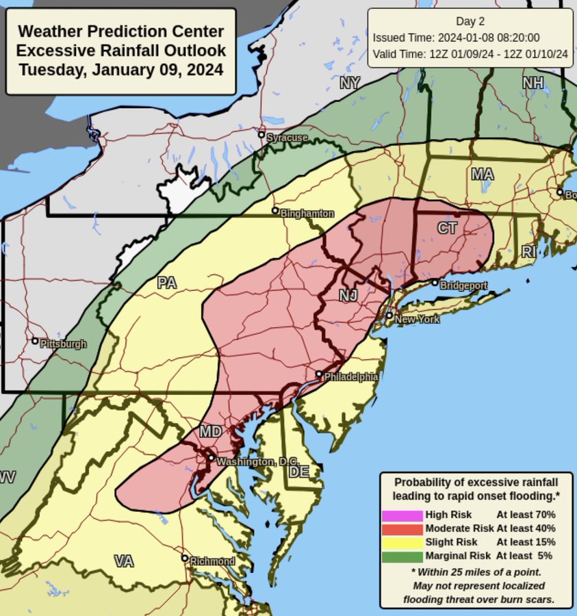
LONG TERM /TUESDAY THROUGH SUNDAY/... *Key Points* * A significant storm system will impact the region Tuesday night into Wednesday. * Heavy rain, and river and coastal flooding are increasingly likely with this system. See hydrology section below. * Strong winds with the potential for 45 to 60 mph gusts, highest along the coast, Tuesday night into early Wednesday are also possible. A major storm system will impact the area Tuesday night into Wednesday with heavy rain and both river and coastal flooding. Models have been in good overall agreement for sometime now in taking a strengthening low northward across the Midwest and Great Lakes Tuesday into Tuesday night, sending a strong frontal system into the region. Deep-layered lift with the potential for record breaking PWAT values (1.25-1.40"), is setting the stage for heavy rainfall to overspread the area Tuesday afternoon and evening. Rainfall rates for about a 6-h timeframe will be between 0.25 to 0.50 inches, with locally higher rates possible. This will result in a widespread 2 to 4 inches of rainfall with locally higher amounts. A strong SE flow will likely enhance orographic lift for areas west of NYC up into portions of the Lower Hudson Valley and SW CT. NBM probabilities for greater than 2 inches are near 100 percent with much of the area greater than 50 percent for exceeding 3 inches. In addition, snowpack across portions of the area may include up to an inch liquid equivalent. This combined with saturated soils, high streamflow, and low FFG, points to the greatest potential of widespread flooding across NE NJ and the Lower Hudson Valley. WPC also has placed this area under a Moderate Risk of exceeding flash flood guidance. Many of the faster responding streams and rivers across this area will likely go into flood with these forecast rainfall amounts. Several river forecast points are also forecast to reach moderate benchmarks. Thus, a Flood Watch is in effect for these areas. There will likely be refinement and expansion of these areas in coming days. The heaviest rains will then exit the area by daybreak Wednesday with some lingering rain possible as the upper low/trough move through the area. Another potential hazard will be high winds, especially along the coasts with SE gusts of 50 to 60 mph possible. A high wind watch has been issued for LI and may very well need to be expanded to the CT coast in later forecasts. Elsewhere, Wind Advisory level winds are possible elsewhere. At this time, used a blend of the NBM and NBMexp which seemed to best represent the wind and gust potential based on model soundings.
_________________
_______________________________________________________________________________________________________
CLICK HERE to view NJ Strong Snowstorm Classifications
Frank_Wx- Godzilla Seeker
- Posts : 21305
Reputation : 328
Join date : 2013-01-05
Age : 31
Location : Jersey City, NJ -
Re: JAN 9th-10th Flooding Threat
![]() by weatherwatchermom Sun Jan 07, 2024 11:15 pm
by weatherwatchermom Sun Jan 07, 2024 11:15 pm
Frank_Wx wrote:jmanley32 wrote:If you look close and count the levels of purple thas actually 4-4.5...Frank_Wx wrote:The Canadian is much wetter. Widespread 3" amounts. Even 3.5" in north-central jersey. Looks like Morristown area.
I think the lightest shade of pink/purple starts the 2” mark
this will be catastrophic for the areas that were flooded not long ago.

weatherwatchermom- Senior Enthusiast
- Posts : 3738
Reputation : 77
Join date : 2014-11-25
Age : 60
Location : Hazlet Township, NJ
Re: JAN 9th-10th Flooding Threat
![]() by jmanley32 Mon Jan 08, 2024 4:17 am
by jmanley32 Mon Jan 08, 2024 4:17 am
well then clear increase on gfs from previous run and im surprised you even posted hi res nam dont you think thats beyond overdone? I mean 79mph in white plains?! That would not be good at all. Do you think rain could exceed 4 inches or is that the ceiling. I sure hope the latter. Syill no wind alerts for ct or nyc/ westchester not sure why nws is waiting being they have issued most other areas.Frank_Wx wrote:Hi Res NAM wind gusts
00z GFS wind gusts

jmanley32- Senior Enthusiast
- Posts : 20516
Reputation : 108
Join date : 2013-12-12
Age : 42
Location : Yonkers, NY
Re: JAN 9th-10th Flooding Threat
![]() by jmanley32 Mon Jan 08, 2024 4:25 am
by jmanley32 Mon Jan 08, 2024 4:25 am
not to mention some of those areas have 6 plus inches of snow. Which could add .5 to 1.0 if its calculated in qpf. Wed morning commute will be a disaster.weatherwatchermom wrote:Frank_Wx wrote:jmanley32 wrote:If you look close and count the levels of purple thas actually 4-4.5...Frank_Wx wrote:The Canadian is much wetter. Widespread 3" amounts. Even 3.5" in north-central jersey. Looks like Morristown area.
I think the lightest shade of pink/purple starts the 2” mark
this will be catastrophic for the areas that were flooded not long ago.
jmanley32- Senior Enthusiast
- Posts : 20516
Reputation : 108
Join date : 2013-12-12
Age : 42
Location : Yonkers, NY
Re: JAN 9th-10th Flooding Threat
![]() by jmanley32 Mon Jan 08, 2024 5:05 am
by jmanley32 Mon Jan 08, 2024 5:05 am


Last edited by jmanley32 on Mon Jan 08, 2024 6:16 am; edited 1 time in total
jmanley32- Senior Enthusiast
- Posts : 20516
Reputation : 108
Join date : 2013-12-12
Age : 42
Location : Yonkers, NY
Re: JAN 9th-10th Flooding Threat
![]() by jmanley32 Mon Jan 08, 2024 6:09 am
by jmanley32 Mon Jan 08, 2024 6:09 am

jmanley32- Senior Enthusiast
- Posts : 20516
Reputation : 108
Join date : 2013-12-12
Age : 42
Location : Yonkers, NY
Re: JAN 9th-10th Flooding Threat
![]() by amugs Mon Jan 08, 2024 11:11 am
by amugs Mon Jan 08, 2024 11:11 am
GFS wind map you can cut by 25% but still its roaring.

_________________
Mugs
AKA:King: Snow Weenie
Self Proclaimed
WINTER 2014-15 : 55.12" +.02 for 6 coatings (avg. 35")
WINTER 2015-16 Total - 29.8" (Avg 35")
WINTER 2016-17 : 39.5" so far

amugs- Advanced Forecaster - Mod

- Posts : 15093
Reputation : 213
Join date : 2013-01-07
Age : 54
Location : Hillsdale,NJ
Re: JAN 9th-10th Flooding Threat
![]() by amugs Mon Jan 08, 2024 11:20 am
by amugs Mon Jan 08, 2024 11:20 am
MONSTER WINDS TUESDAY NIGHT.. MULTI-STATE WIND DAMAGE THREAT
— Mike Masco (@MikeMasco) January 8, 2024
Here we are again! We are at another cross roads on whether to accept the idea of a 70-80mph wind gust potential from MD to ME!
Wind forecasting is a big challenge as a forecaster needs to factor in how much wind… pic.twitter.com/c5VRvXLsdW
_________________
Mugs
AKA:King: Snow Weenie
Self Proclaimed
WINTER 2014-15 : 55.12" +.02 for 6 coatings (avg. 35")
WINTER 2015-16 Total - 29.8" (Avg 35")
WINTER 2016-17 : 39.5" so far
amugs- Advanced Forecaster - Mod
- Posts : 15093
Reputation : 213
Join date : 2013-01-07
Age : 54
Location : Hillsdale,NJ
Re: JAN 9th-10th Flooding Threat
![]() by jmanley32 Mon Jan 08, 2024 11:30 am
by jmanley32 Mon Jan 08, 2024 11:30 am
yikes! Why do you think The NWS has not issued wind headlines for NE NJ, Westchester/NYC and coastal CT? Even inland this is going to be advisory criteria, I thing HWW for all coastal and the areas I just mentioned. if winds hit 70-80 MPH even 60-70 there is going to be massive outages.amugs wrote:He's beenspot on the last number of storms and makes valid pts.MONSTER WINDS TUESDAY NIGHT.. MULTI-STATE WIND DAMAGE THREAT
— Mike Masco (@MikeMasco) January 8, 2024
Here we are again! We are at another cross roads on whether to accept the idea of a 70-80mph wind gust potential from MD to ME!
Wind forecasting is a big challenge as a forecaster needs to factor in how much wind… pic.twitter.com/c5VRvXLsdW
jmanley32- Senior Enthusiast
- Posts : 20516
Reputation : 108
Join date : 2013-12-12
Age : 42
Location : Yonkers, NY
Re: JAN 9th-10th Flooding Threat
![]() by amugs Mon Jan 08, 2024 11:57 am
by amugs Mon Jan 08, 2024 11:57 am

_________________
Mugs
AKA:King: Snow Weenie
Self Proclaimed
WINTER 2014-15 : 55.12" +.02 for 6 coatings (avg. 35")
WINTER 2015-16 Total - 29.8" (Avg 35")
WINTER 2016-17 : 39.5" so far
amugs- Advanced Forecaster - Mod
- Posts : 15093
Reputation : 213
Join date : 2013-01-07
Age : 54
Location : Hillsdale,NJ
Re: JAN 9th-10th Flooding Threat
![]() by amugs Mon Jan 08, 2024 11:58 am
by amugs Mon Jan 08, 2024 11:58 am
jmanley32 wrote:yikes! Why do you think The NWS has not issued wind headlines for NE NJ, Westchester/NYC and coastal CT? Even inland this is going to be advisory criteria, I thing HWW for all coastal and the areas I just mentioned. if winds hit 70-80 MPH even 60-70 there is going to be massive outages.amugs wrote:He's beenspot on the last number of storms and makes valid pts.MONSTER WINDS TUESDAY NIGHT.. MULTI-STATE WIND DAMAGE THREAT
— Mike Masco (@MikeMasco) January 8, 2024
Here we are again! We are at another cross roads on whether to accept the idea of a 70-80mph wind gust potential from MD to ME!
Wind forecasting is a big challenge as a forecaster needs to factor in how much wind… pic.twitter.com/c5VRvXLsdW
Upton will wait.
_________________
Mugs
AKA:King: Snow Weenie
Self Proclaimed
WINTER 2014-15 : 55.12" +.02 for 6 coatings (avg. 35")
WINTER 2015-16 Total - 29.8" (Avg 35")
WINTER 2016-17 : 39.5" so far
amugs- Advanced Forecaster - Mod
- Posts : 15093
Reputation : 213
Join date : 2013-01-07
Age : 54
Location : Hillsdale,NJ
phil155 likes this post
Re: JAN 9th-10th Flooding Threat
![]() by rb924119 Mon Jan 08, 2024 12:27 pm
by rb924119 Mon Jan 08, 2024 12:27 pm
rb924119- Meteorologist

- Posts : 6890
Reputation : 194
Join date : 2013-02-06
Age : 32
Location : Greentown, Pa
Re: JAN 9th-10th Flooding Threat
![]() by jmanley32 Mon Jan 08, 2024 12:34 pm
by jmanley32 Mon Jan 08, 2024 12:34 pm
what sbout over here do you think the met above could b right could we really see close to if not hurricane force gusts?rb924119 wrote:I just took a quick look at some forecast soundings for my local area here in NEPA, and it doesn’t look good. AT ALL. However, with the snowpack, I’m hoping that it can help induce a stout extremely low-level inversion to help prevent mixing just long enough to allow the core of the strongest winds to pass overhead. I have to look at this more closely later. But I’m hoping the same thing can occur for everybody else that just got snow.
jmanley32- Senior Enthusiast
- Posts : 20516
Reputation : 108
Join date : 2013-12-12
Age : 42
Location : Yonkers, NY
Re: JAN 9th-10th Flooding Threat
![]() by jmanley32 Mon Jan 08, 2024 12:36 pm
by jmanley32 Mon Jan 08, 2024 12:36 pm
but what are they wait for i think this potential at least warrents a HW watch. Or are they go wait till going straight to warning or advisory. Why are they always last to make decision lolamugs wrote:jmanley32 wrote:yikes! Why do you think The NWS has not issued wind headlines for NE NJ, Westchester/NYC and coastal CT? Even inland this is going to be advisory criteria, I thing HWW for all coastal and the areas I just mentioned. if winds hit 70-80 MPH even 60-70 there is going to be massive outages.amugs wrote:He's beenspot on the last number of storms and makes valid pts.MONSTER WINDS TUESDAY NIGHT.. MULTI-STATE WIND DAMAGE THREAT
— Mike Masco (@MikeMasco) January 8, 2024
Here we are again! We are at another cross roads on whether to accept the idea of a 70-80mph wind gust potential from MD to ME!
Wind forecasting is a big challenge as a forecaster needs to factor in how much wind… pic.twitter.com/c5VRvXLsdW
Upton will wait.
jmanley32- Senior Enthusiast
- Posts : 20516
Reputation : 108
Join date : 2013-12-12
Age : 42
Location : Yonkers, NY
Re: JAN 9th-10th Flooding Threat
![]() by phil155 Mon Jan 08, 2024 12:36 pm
by phil155 Mon Jan 08, 2024 12:36 pm
amugs wrote:jmanley32 wrote:yikes! Why do you think The NWS has not issued wind headlines for NE NJ, Westchester/NYC and coastal CT? Even inland this is going to be advisory criteria, I thing HWW for all coastal and the areas I just mentioned. if winds hit 70-80 MPH even 60-70 there is going to be massive outages.amugs wrote:He's beenspot on the last number of storms and makes valid pts.MONSTER WINDS TUESDAY NIGHT.. MULTI-STATE WIND DAMAGE THREAT
— Mike Masco (@MikeMasco) January 8, 2024
Here we are again! We are at another cross roads on whether to accept the idea of a 70-80mph wind gust potential from MD to ME!
Wind forecasting is a big challenge as a forecaster needs to factor in how much wind… pic.twitter.com/c5VRvXLsdW
Upton will wait.
I have to think this will not verify, but as mentioned earlier even 65-75% of this for gusts will be a problem. This would be almost Sandy like in terms of winds if it verified
phil155- Pro Enthusiast

- Posts : 475
Reputation : 4
Join date : 2019-12-16
Re: JAN 9th-10th Flooding Threat
![]() by weatherwatchermom Mon Jan 08, 2024 12:44 pm
by weatherwatchermom Mon Jan 08, 2024 12:44 pm
And you don't think the Jersey coast?? LOL we already have high winter watch posted..jmanley32 wrote:yikes! Why do you think The NWS has not issued wind headlines for NE NJ, Westchester/NYC and coastal CT? Even inland this is going to be advisory criteria, I thing HWW for all coastal and the areas I just mentioned. if winds hit 70-80 MPH even 60-70 there is going to be massive outages.amugs wrote:He's beenspot on the last number of storms and makes valid pts.MONSTER WINDS TUESDAY NIGHT.. MULTI-STATE WIND DAMAGE THREAT
— Mike Masco (@MikeMasco) January 8, 2024
Here we are again! We are at another cross roads on whether to accept the idea of a 70-80mph wind gust potential from MD to ME!
Wind forecasting is a big challenge as a forecaster needs to factor in how much wind… pic.twitter.com/c5VRvXLsdW
weatherwatchermom- Senior Enthusiast
- Posts : 3738
Reputation : 77
Join date : 2014-11-25
Age : 60
Location : Hazlet Township, NJ
Re: JAN 9th-10th Flooding Threat
![]() by jmanley32 Mon Jan 08, 2024 12:49 pm
by jmanley32 Mon Jan 08, 2024 12:49 pm
Didn't mention them cuz as you said you have a HWW, I dunno what engraved invitation Upton is waiting for, literally HWW all way to south of NYC (Atlantic city I believe) then nothing then LI and RI/MA. NYC area, coastal CT have nothing, As i said guess they may be waiting to see if the inversion might allow for those insane numbers to verify.weatherwatchermom wrote:And you don't think the Jersey coast?? LOL we already have high winter watch posted..jmanley32 wrote:yikes! Why do you think The NWS has not issued wind headlines for NE NJ, Westchester/NYC and coastal CT? Even inland this is going to be advisory criteria, I thing HWW for all coastal and the areas I just mentioned. if winds hit 70-80 MPH even 60-70 there is going to be massive outages.amugs wrote:He's beenspot on the last number of storms and makes valid pts.MONSTER WINDS TUESDAY NIGHT.. MULTI-STATE WIND DAMAGE THREAT
— Mike Masco (@MikeMasco) January 8, 2024
Here we are again! We are at another cross roads on whether to accept the idea of a 70-80mph wind gust potential from MD to ME!
Wind forecasting is a big challenge as a forecaster needs to factor in how much wind… pic.twitter.com/c5VRvXLsdW
jmanley32- Senior Enthusiast
- Posts : 20516
Reputation : 108
Join date : 2013-12-12
Age : 42
Location : Yonkers, NY
Re: JAN 9th-10th Flooding Threat
![]() by rb924119 Mon Jan 08, 2024 12:56 pm
by rb924119 Mon Jan 08, 2024 12:56 pm
jmanley32 wrote:what sbout over here do you think the met above could b right could we really see close to if not hurricane force gusts?rb924119 wrote:I just took a quick look at some forecast soundings for my local area here in NEPA, and it doesn’t look good. AT ALL. However, with the snowpack, I’m hoping that it can help induce a stout extremely low-level inversion to help prevent mixing just long enough to allow the core of the strongest winds to pass overhead. I have to look at this more closely later. But I’m hoping the same thing can occur for everybody else that just got snow.
I haven’t looked yet, but I will tonight after work. However, it seems like a setup where the atmospheric column will be pretty isothermal through the boundary layer (meaning the temperatures are approximately the same through 850 hPa). This would mean that there’s no inversion, and momentum transfer would be efficient, and allow the high winds to mix down, especially with any convection. So yeah, at face value, his thoughts seem valid to me.
rb924119- Meteorologist
- Posts : 6890
Reputation : 194
Join date : 2013-02-06
Age : 32
Location : Greentown, Pa
Re: JAN 9th-10th Flooding Threat
![]() by jmanley32 Mon Jan 08, 2024 12:59 pm
by jmanley32 Mon Jan 08, 2024 12:59 pm
I am confused, I thought weak inversion meant the winds wouldn't mix down, inversion is the opposite you want it to be weak? Yeah def let us know ur thoughts later. gotta ready Upton's disco not sure if a new one is out and if they explain why they are holding off on wind headlines for NYC are and CT.rb924119 wrote:jmanley32 wrote:what sbout over here do you think the met above could b right could we really see close to if not hurricane force gusts?rb924119 wrote:I just took a quick look at some forecast soundings for my local area here in NEPA, and it doesn’t look good. AT ALL. However, with the snowpack, I’m hoping that it can help induce a stout extremely low-level inversion to help prevent mixing just long enough to allow the core of the strongest winds to pass overhead. I have to look at this more closely later. But I’m hoping the same thing can occur for everybody else that just got snow.
I haven’t looked yet, but I will tonight after work. However, it seems like a setup where the atmospheric column will be pretty isothermal through the boundary layer (meaning the temperatures are approximately the same through 850 hPa). This would mean that there’s no inversion, and momentum transfer would be efficient, and allow the high winds to mix down, especially with any convection. So yeah, at face value, his thoughts seem valid to me.
jmanley32- Senior Enthusiast
- Posts : 20516
Reputation : 108
Join date : 2013-12-12
Age : 42
Location : Yonkers, NY
Re: JAN 9th-10th Flooding Threat
![]() by rb924119 Mon Jan 08, 2024 1:09 pm
by rb924119 Mon Jan 08, 2024 1:09 pm
jmanley32 wrote:I am confused, I thought weak inversion meant the winds wouldn't mix down, inversion is the opposite you want it to be weak? Yeah def let us know ur thoughts later. gotta ready Upton's disco not sure if a new one is out and if they explain why they are holding off on wind headlines for NYC are and CT.rb924119 wrote:jmanley32 wrote:what sbout over here do you think the met above could b right could we really see close to if not hurricane force gusts?rb924119 wrote:I just took a quick look at some forecast soundings for my local area here in NEPA, and it doesn’t look good. AT ALL. However, with the snowpack, I’m hoping that it can help induce a stout extremely low-level inversion to help prevent mixing just long enough to allow the core of the strongest winds to pass overhead. I have to look at this more closely later. But I’m hoping the same thing can occur for everybody else that just got snow.
I haven’t looked yet, but I will tonight after work. However, it seems like a setup where the atmospheric column will be pretty isothermal through the boundary layer (meaning the temperatures are approximately the same through 850 hPa). This would mean that there’s no inversion, and momentum transfer would be efficient, and allow the high winds to mix down, especially with any convection. So yeah, at face value, his thoughts seem valid to me.
The stronger an inversion is, the harder it is for wind to mix down to the surface. In this case, I don’t think that there will be an inversion along the coast because the thermal profile appears generally isothermal (uniform) from the surface through 850 hPa.So, high winds appear to be a legitimate threat. Inland where there’s snowpack, my hope is that the snow can help induce a very low-level inversion just above the surface to help limit the mixing of the high winds to the surface there. But I’m not sure that will happen, and have to look at all of it later.
rb924119- Meteorologist
- Posts : 6890
Reputation : 194
Join date : 2013-02-06
Age : 32
Location : Greentown, Pa
Grselig likes this post
Re: JAN 9th-10th Flooding Threat
![]() by amugs Mon Jan 08, 2024 1:37 pm
by amugs Mon Jan 08, 2024 1:37 pm
Jersey shore will have possible moderate to major coastal flooding as well. Upton playing politicas again by utter silence or waiting?
SE winds will rake the area 40 -50 MPH inland and LI and Jersey Shore up to 65/70mph is not out of the question.
Unless we see models backing off this is a worry.
NNJ does not do well with SE winds nor does the shore.
_________________
Mugs
AKA:King: Snow Weenie
Self Proclaimed
WINTER 2014-15 : 55.12" +.02 for 6 coatings (avg. 35")
WINTER 2015-16 Total - 29.8" (Avg 35")
WINTER 2016-17 : 39.5" so far
amugs- Advanced Forecaster - Mod
- Posts : 15093
Reputation : 213
Join date : 2013-01-07
Age : 54
Location : Hillsdale,NJ
Re: JAN 9th-10th Flooding Threat
![]() by Dunnzoo Mon Jan 08, 2024 1:40 pm
by Dunnzoo Mon Jan 08, 2024 1:40 pm
jmanley32 wrote:Didn't mention them cuz as you said you have a HWW, I dunno what engraved invitation Upton is waiting for, literally HWW all way to south of NYC (Atlantic city I believe) then nothing then LI and RI/MA. NYC area, coastal CT have nothing, As i said guess they may be waiting to see if the inversion might allow for those insane numbers to verify.weatherwatchermom wrote:And you don't think the Jersey coast?? LOL we already have high winter watch posted..jmanley32 wrote:yikes! Why do you think The NWS has not issued wind headlines for NE NJ, Westchester/NYC and coastal CT? Even inland this is going to be advisory criteria, I thing HWW for all coastal and the areas I just mentioned. if winds hit 70-80 MPH even 60-70 there is going to be massive outages.amugs wrote:He's beenspot on the last number of storms and makes valid pts.MONSTER WINDS TUESDAY NIGHT.. MULTI-STATE WIND DAMAGE THREAT
— Mike Masco (@MikeMasco) January 8, 2024
Here we are again! We are at another cross roads on whether to accept the idea of a 70-80mph wind gust potential from MD to ME!
Wind forecasting is a big challenge as a forecaster needs to factor in how much wind… pic.twitter.com/c5VRvXLsdW
Easy jman, they are late quite often on watches, warnings etc. No news is good news, if they haven't issued one yet, they aren't concerned yet. We are still 24 hours away from start time, there is plenty of time to put out additional watches/warnings. I would rather they take their time and get it right then go early and have to retract or adjust.
_________________
Janet
Snowfall winter of 2023-2024 17.5"
Snowfall winter of 2022-2023 6.0"
Snowfall winter of 2021-2022 17.6" 1" sleet 2/25/22
Snowfall winter of 2020-2021 51.1"
Snowfall winter of 2019-2020 8.5"
Snowfall winter of 2018-2019 25.1"
Snowfall winter of 2017-2018 51.9"
Snowfall winter of 2016-2017 45.6"
Snowfall winter of 2015-2016 29.5"
Snowfall winter of 2014-2015 50.55"
Snowfall winter of 2013-2014 66.5"

Dunnzoo- Senior Enthusiast - Mod
- Posts : 4891
Reputation : 68
Join date : 2013-01-11
Age : 62
Location : Westwood, NJ
Frank_Wx likes this post
Re: JAN 9th-10th Flooding Threat
![]() by rb924119 Mon Jan 08, 2024 1:45 pm
by rb924119 Mon Jan 08, 2024 1:45 pm
amugs wrote:Ida 2.0 peeps, prepare the ark and the generators is all I am saying. call it hype or what you want but models are noty backing down from winds nor flooding potentital.
Jersey shore will have possible moderate to major coastal flooding as well. Upton playing politicas again by utter silence or waiting?
SE winds will rake the area 40 -50 MPH inland and LI and Jersey Shore up to 65/70mph is not out of the question.
Unless we see models backing off this is a worry.
NNJ does not do well with SE winds nor does the shore.
The bolded/italicized point is extremely poignant, and I was just talking to a friend/employer of mine who owns a tree service about this. Our climatological wind direction is west-northwest, so trees are used to added stress from that direction and grow accordingly. However, this will have an anomalous southerly/easterly component, which, if the wind potential is realized, will result in additional damage that we wouldn’t otherwise see if it was west-northwest wind, because that is the weaker side of the tree’s fibers. This goes for everywhere north and west of I-95. A secondary factor is that we have snow load up here.
rb924119- Meteorologist
- Posts : 6890
Reputation : 194
Join date : 2013-02-06
Age : 32
Location : Greentown, Pa
Page 2 of 18 • 1, 2, 3 ... 10 ... 18 ![]()
|
|
|