
 Search
JAN 16th Arctic Front I
Page 1 of 8 • 1, 2, 3, 4, 5, 6, 7, 8 ![]()

JAN 16th Arctic Front I
![]() by Frank_Wx Sun Jan 14, 2024 5:23 pm
by Frank_Wx Sun Jan 14, 2024 5:23 pm
Here's the 500mb map by the EURO valid for Tuesday afternoon:
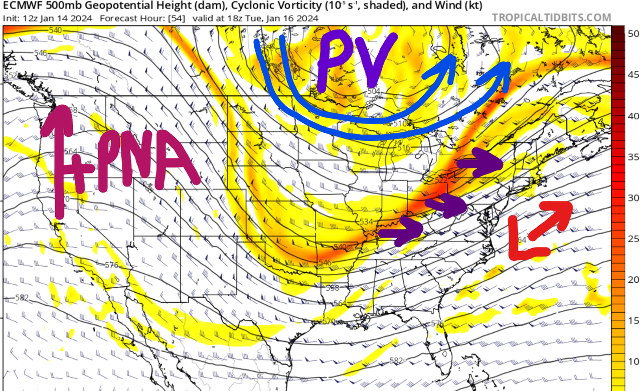
The Polar Vortex is anchored in the southern part of the Hudson Bay and there is a positively tilted trough swinging through the south-central U.S. I am labeling Tuesday's storm as an "arctic front" because of how the 500mb energy is strung out along the leading edge of this trough and the temperature gradient that formed along the east coast. These features, along with a surface low pressure that forms off the coast of the Mid-Atlantic ahead of this trough, are the key ingredients to Tuesday's snowfall. The trough itself will swing through our area late Tuesday night / early Wednesday morning AFTER all of the precip from the front has fallen. This eventually sets the stage for a potential storm on Friday JAN 19th, but I'll keep my thoughts for that one in the long range thread.
What's interesting is the short range models have a lot of upper energy ahead of the front. This causes snow to break out as early as Monday evening - say around 7pm - while the globals do not have any snow starting until 2am Tuesday. I actually think there will be a blend of the two. I am inclined to take the start time of the globals, especially when you factor into virga/dry air, but the QPF output of the short range models. The reason I feel strongly about what the short range models are showing has to do with the amount of 500mb/700mb vorticity passing through the area, and the role of the 250mb jet streak.

First off, your pressure gradients along the immediate coast are fairly tight which usually leads to strong frontogenesis along the baroclinic zone. Check out the 850mb temp differences behind and ahead of the front.

Now factor in the 250mb jet - valid early Tuesday morning - where 150 Kt winds will gradually increase to 180 Kt as the day goes on. This helps create a level of instability in the upper atmosphere which should allow for precipitation to expand well N&W of I-95.

In fact, the EURO has the most impressive 700mb vorticity N&W of I-95 but even I-95 and points S&E benefit as well. The one thing to watch out for - and the NAM kinda shows this - is that if the surface low tracks too close to the coast, it pushes the best dynamics N&W of I-95 and causes the immediate coast to dry slot (while also seeing temperatures warm above freezing). Right now, I am not buying into the surface low tracking as close as the NAM/RGEM show because the oncoming Arctic front should be strong enough to keep the low south and east.
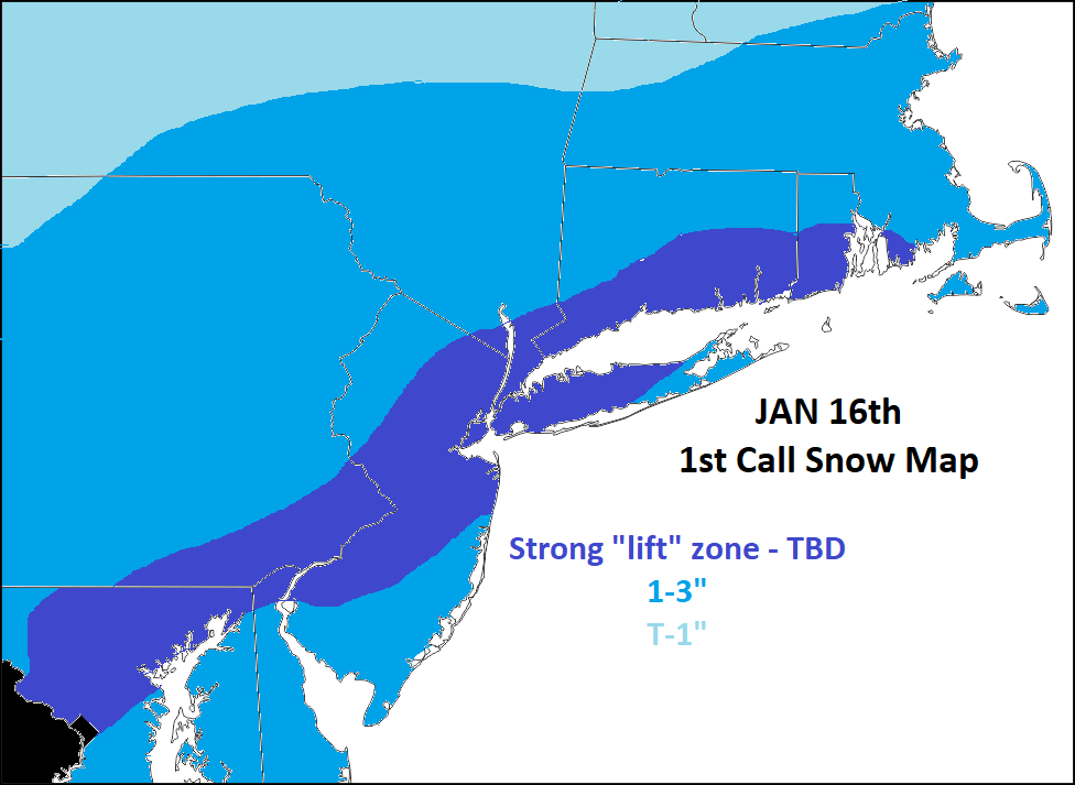
Overall this will be a general 1" to 3" across a widespread region. The reach is impressive due to the dynamics at play between 250mb and 850mb. There will be a narrow zone that experiences heavier snowfall rates thanks to the temperature gradients just N&W of wherever the baroclinic zone lies. This area is always difficult to forecast. I do think the short range models are onto something with their narrow swath of 3-5". Right now, I think the area in the darker shading of blue is in play to be within that zone. However, this zone can very easily shift (either N&W or S&E) depending on where the final track of the low and 250mb jet.
Final call snow map

Last edited by Frank_Wx on Mon Jan 15, 2024 1:23 pm; edited 1 time in total
_________________
_______________________________________________________________________________________________________
CLICK HERE to view NJ Strong Snowstorm Classifications

Frank_Wx- Godzilla Seeker

- Posts : 21305
Reputation : 328
Join date : 2013-01-05
Age : 31
Location : Jersey City, NJ -

kalleg, nancy-j-s, brownie, 1190ftalt, heehaw453, weatherwatchermom, SENJsnowman and like this post
Re: JAN 16th Arctic Front I
![]() by Coachgriff Sun Jan 14, 2024 5:32 pm
by Coachgriff Sun Jan 14, 2024 5:32 pm
Coachgriff- Posts : 57
Reputation : 0
Join date : 2022-01-29
Re: JAN 16th Arctic Front I
![]() by jmanley32 Sun Jan 14, 2024 6:21 pm
by jmanley32 Sun Jan 14, 2024 6:21 pm

jmanley32- Senior Enthusiast

- Posts : 20516
Reputation : 108
Join date : 2013-12-12
Age : 42
Location : Yonkers, NY
kalleg likes this post
Re: JAN 16th Arctic Front I
![]() by heehaw453 Sun Jan 14, 2024 8:11 pm
by heehaw453 Sun Jan 14, 2024 8:11 pm

heehaw453- Advanced Forecaster

- Posts : 3906
Reputation : 86
Join date : 2014-01-20
Location : Bedminster Township, PA Elevation 600' ASL
Re: JAN 16th Arctic Front I
![]() by jmanley32 Sun Jan 14, 2024 8:32 pm
by jmanley32 Sun Jan 14, 2024 8:32 pm
Does that mean Franks dark zone would be out of the 3-5? Cuz honestly I will take that at this point, 1-3 his kinda not much especially 1 but 3 id be loving and 5 would be awesome. Whats the absolute ceiling on this? We are only 1 day out so it must be pretty much in stone soon. Thanks guys for your hard work.heehaw453 wrote:The 18Z Euro. The jet streak really fires up here to the NW. The storm probably is going to intensify as that streak picks up. I think Euro might be underdoing the precip NW and I won't be surprised to see 3-5" in Poconos/NW NJ/LHV with this.
jmanley32- Senior Enthusiast
- Posts : 20516
Reputation : 108
Join date : 2013-12-12
Age : 42
Location : Yonkers, NY
Re: JAN 16th Arctic Front I
![]() by Frank_Wx Sun Jan 14, 2024 8:37 pm
by Frank_Wx Sun Jan 14, 2024 8:37 pm
jmanley32 wrote:Does that mean Franks dark zone would be out of the 3-5? Cuz honestly I will take that at this point, 1-3 his kinda not much especially 1 but 3 id be loving and 5 would be awesome. Whats the absolute ceiling on this? We are only 1 day out so it must be pretty much in stone soon. Thanks guys for your hard work.heehaw453 wrote:The 18Z Euro. The jet streak really fires up here to the NW. The storm probably is going to intensify as that streak picks up. I think Euro might be underdoing the precip NW and I won't be surprised to see 3-5" in Poconos/NW NJ/LHV with this.
My dark zone represents where I think 3”+ is possible based off of rates. My forecast is 1-3” even for those in the dark zone. However, in my final call map I may create a 3-5” zone if I see modeling shift toward my ideas. So far just the NAM and RGEM agree with my logic and that’s not exactly a vote of confidence.
_________________
_______________________________________________________________________________________________________
CLICK HERE to view NJ Strong Snowstorm Classifications
Frank_Wx- Godzilla Seeker
- Posts : 21305
Reputation : 328
Join date : 2013-01-05
Age : 31
Location : Jersey City, NJ -
kalleg and heehaw453 like this post
Re: JAN 16th Arctic Front I
![]() by aiannone Sun Jan 14, 2024 8:55 pm
by aiannone Sun Jan 14, 2024 8:55 pm
Frank_Wx wrote:Let's take a look at what is to come on Tuesday. There is a battle happening between the global and short range models. The short range, or higher resolutions, show a maximum in the precip of 0.6" with a general range of 0.3" to 0.5". Whereas, the globals show a maximum of 0.4" with a general range of 0.1" to 0.3". In terms of snow, assuming a 10:1 ratio, this means the difference between a 1-3" or a 3-5" event.
Here's the 500mb map by the EURO valid for Tuesday afternoon:
The Polar Vortex is anchored in the southern part of the Hudson Bay and there is a positively tilted trough swinging through the south-central U.S. I am labeling Tuesday's storm as an "arctic front" because of how the 500mb energy is strung out along the leading edge of this trough and the temperature gradient that formed along the east coast. These features, along with a surface low pressure that forms off the coast of the Mid-Atlantic ahead of this trough, are the key ingredients to Tuesday's snowfall. The trough itself will swing through our area late Tuesday night / early Wednesday morning AFTER all of the precip from the front has fallen. This eventually sets the stage for a potential storm on Friday JAN 19th, but I'll keep my thoughts for that one in the long range thread.
What's interesting is the short range models have a lot of upper energy ahead of the front. This causes snow to break out as early as Monday evening - say around 7pm - while the globals do not have any snow starting until 2am Tuesday. I actually think there will be a blend of the two. I am inclined to take the start time of the globals, especially when you factor into virga/dry air, but the QPF output of the short range models. The reason I feel strongly about what the short range models are showing has to do with the amount of 500mb/700mb vorticity passing through the area, and the role of the 250mb jet streak.
First off, your pressure gradients along the immediate coast are fairly tight which usually leads to strong frontogenesis along the baroclinic zone. Check out the 850mb temp differences behind and ahead of the front.
Now factor in the 250mb jet - valid early Tuesday morning - where 150 Kt winds will gradually increase to 180 Kt as the day goes on. This helps create a level of instability in the upper atmosphere which should allow for precipitation to expand well N&W of I-95.
In fact, the EURO has the most impressive 700mb vorticity N&W of I-95 but even I-95 and points S&E benefit as well. The one thing to watch out for - and the NAM kinda shows this - is that if the surface low tracks too close to the coast, it pushes the best dynamics N&W of I-95 and causes the immediate coast to dry slot (while also seeing temperatures warm above freezing). Right now, I am not buying into the surface low tracking as close as the NAM/RGEM show because the oncoming Arctic front should be strong enough to keep the low south and east.
Overall this will be a general 1" to 3" across a widespread region. The reach is impressive due to the dynamics at play between 250mb and 850mb. There will be a narrow zone that experiences heavier snowfall rates thanks to the temperature gradients just N&W of wherever the baroclinic zone lies. This area is always difficult to forecast. I do think the short range models are onto something with their narrow swath of 3-5". Right now, I think the area in the darker shading of blue is in play to be within that zone. However, this zone can very easily shift (either N&W or S&E) depending on where the final track of the low and 250mb jet.
Frank, the 0z hrrr matches your map nicely


aiannone- Senior Enthusiast - Mod

- Posts : 4813
Reputation : 92
Join date : 2013-01-07
Location : Saint James, LI (Northwest Suffolk Co.)
Frank_Wx likes this post
Re: JAN 16th Arctic Front I
![]() by Frank_Wx Sun Jan 14, 2024 9:06 pm
by Frank_Wx Sun Jan 14, 2024 9:06 pm

_________________
_______________________________________________________________________________________________________
CLICK HERE to view NJ Strong Snowstorm Classifications
Frank_Wx- Godzilla Seeker
- Posts : 21305
Reputation : 328
Join date : 2013-01-05
Age : 31
Location : Jersey City, NJ -
heehaw453 likes this post
Re: JAN 16th Arctic Front I
![]() by Frank_Wx Sun Jan 14, 2024 9:09 pm
by Frank_Wx Sun Jan 14, 2024 9:09 pm
_________________
_______________________________________________________________________________________________________
CLICK HERE to view NJ Strong Snowstorm Classifications
Frank_Wx- Godzilla Seeker
- Posts : 21305
Reputation : 328
Join date : 2013-01-05
Age : 31
Location : Jersey City, NJ -
docstox12, essexcountypete, heehaw453, weatherwatchermom, frank 638 and silentwreck like this post
Re: JAN 16th Arctic Front I
![]() by Frank_Wx Sun Jan 14, 2024 9:10 pm
by Frank_Wx Sun Jan 14, 2024 9:10 pm
_________________
_______________________________________________________________________________________________________
CLICK HERE to view NJ Strong Snowstorm Classifications
Frank_Wx- Godzilla Seeker
- Posts : 21305
Reputation : 328
Join date : 2013-01-05
Age : 31
Location : Jersey City, NJ -
nancy-j-s, MattyICE, JT33 and silentwreck like this post
Re: JAN 16th Arctic Front I
![]() by heehaw453 Sun Jan 14, 2024 9:38 pm
by heehaw453 Sun Jan 14, 2024 9:38 pm
Hopefully this holds...

heehaw453- Advanced Forecaster
- Posts : 3906
Reputation : 86
Join date : 2014-01-20
Location : Bedminster Township, PA Elevation 600' ASL
SENJsnowman likes this post
Re: JAN 16th Arctic Front I
![]() by hyde345 Sun Jan 14, 2024 9:40 pm
by hyde345 Sun Jan 14, 2024 9:40 pm

hyde345- Pro Enthusiast

- Posts : 1082
Reputation : 48
Join date : 2013-01-08
Location : Hyde Park, NY
docstox12 and heehaw453 like this post
Re: JAN 16th Arctic Front I
![]() by aiannone Sun Jan 14, 2024 9:50 pm
by aiannone Sun Jan 14, 2024 9:50 pm
heehaw453 wrote:Not too shabby on the 3k NAM too even for Jersey Shore! As the storm makes its closest approach it'll probably mix I95 points SE, but by that time probably won't matter all that much as precip will winding down. The other nice thing for most of this surface temps will be well below freezing and cold thereafter so a snow pack is likely for several days. That's the key with this IMO.
Hopefully this holds...
Yupp we have to hope the brief warm up as the low makes its closest approach doesn’t melt away the couple inches that fall. If we make it through that we will have a snowpack
aiannone- Senior Enthusiast - Mod
- Posts : 4813
Reputation : 92
Join date : 2013-01-07
Location : Saint James, LI (Northwest Suffolk Co.)
JT33 likes this post
Re: JAN 16th Arctic Front I
![]() by weatherwatchermom Sun Jan 14, 2024 10:08 pm
by weatherwatchermom Sun Jan 14, 2024 10:08 pm
Frank_Wx wrote:I think NYC officially breaks their 2 year streak of no snow accumulation on Tuesday.
I hope we do down here as well

weatherwatchermom- Senior Enthusiast
- Posts : 3738
Reputation : 77
Join date : 2014-11-25
Age : 60
Location : Hazlet Township, NJ
Re: JAN 16th Arctic Front I
![]() by aiannone Sun Jan 14, 2024 10:48 pm
by aiannone Sun Jan 14, 2024 10:48 pm

_________________
-Alex Iannone-
aiannone- Senior Enthusiast - Mod
- Posts : 4813
Reputation : 92
Join date : 2013-01-07
Location : Saint James, LI (Northwest Suffolk Co.)
weatherwatchermom and silentwreck like this post
Re: JAN 16th Arctic Front I
![]() by silentwreck Mon Jan 15, 2024 3:59 am
by silentwreck Mon Jan 15, 2024 3:59 am
silentwreck- Posts : 45
Reputation : 0
Join date : 2023-12-18
Location : Queens, NY
Re: JAN 16th Arctic Front I
![]() by Abba701 Mon Jan 15, 2024 5:22 am
by Abba701 Mon Jan 15, 2024 5:22 am
Abba701- Posts : 328
Reputation : 0
Join date : 2013-01-14
Re: JAN 16th Arctic Front I
![]() by Irish Mon Jan 15, 2024 6:18 am
by Irish Mon Jan 15, 2024 6:18 am
Execute a pre-planned activity identified in the instructions
Issued By
Philadelphia - PA, US, National Weather Service
Affected Area
Portions of central, northern and northwest New Jersey
Description
...WINTER WEATHER ADVISORY IN EFFECT FROM 7 PM THIS EVENING TO 4 PM EST TUESDAY...
WHAT...Total snow accumulations of 2 to 4 inches and ice accumulations of a light glaze.
WHERE...Portions of central, northern and northwest New Jersey.
WHEN...From 7 PM this evening to 4 PM EST Tuesday.
IMPACTS...Plan on slippery road conditions. The hazardous conditions could impact the morning or evening commute.
ADDITIONAL DETAILS...Snow expected this evening into tonight. A change over to mixed precipitation is likely Tuesday morning for more southeastern areas.
PRECAUTIONARY/PREPAREDNESS ACTIONS...
Slow down and use caution while traveling.
The latest road conditions for the state you are calling from can be obtained by calling 5 1 1.

Irish- Pro Enthusiast
- Posts : 788
Reputation : 19
Join date : 2019-01-16
Age : 45
Location : Old Bridge, NJ
kalleg and phil155 like this post
Re: JAN 16th Arctic Front I
![]() by Irish Mon Jan 15, 2024 6:20 am
by Irish Mon Jan 15, 2024 6:20 am
Irish- Pro Enthusiast
- Posts : 788
Reputation : 19
Join date : 2019-01-16
Age : 45
Location : Old Bridge, NJ
Re: JAN 16th Arctic Front I
![]() by heehaw453 Mon Jan 15, 2024 7:51 am
by heehaw453 Mon Jan 15, 2024 7:51 am
heehaw453- Advanced Forecaster
- Posts : 3906
Reputation : 86
Join date : 2014-01-20
Location : Bedminster Township, PA Elevation 600' ASL
weatherwatchermom and JT33 like this post
Re: JAN 16th Arctic Front I
![]() by heehaw453 Mon Jan 15, 2024 7:52 am
by heehaw453 Mon Jan 15, 2024 7:52 am
Irish wrote:Looks like the timing moved up. Instead of 1 inch tonight and 1-3 tomorrow. It's 1-3 tonight and 1 inch tomorrow.
Probably starts for many by 9 or 10 tonight.
heehaw453- Advanced Forecaster
- Posts : 3906
Reputation : 86
Join date : 2014-01-20
Location : Bedminster Township, PA Elevation 600' ASL
Re: JAN 16th Arctic Front I
![]() by sroc4 Mon Jan 15, 2024 7:58 am
by sroc4 Mon Jan 15, 2024 7:58 am
heehaw453 wrote:I think this will be a nice little event. What I can also say is if the Atlantic flow wasn't progressive this would have morphed into a big deal.
Yup. I think the combo of no real 50/50 was the first thing that started limiting this systems ceiling; then once it became apparent the pesky northern stream s/w knocking down the WC ridge was real both of those combined really put the cap on the potential. BUT it does go to show when the TPV is sitting just to the north thanks to the high lat blocking, we can still cash in.
BTW you did a great job highlighting both aspects along the way.
_________________
"In weather and in life, there's no winning and losing; there's only winning and learning."
WINTER 2012/2013 TOTALS 43.65"WINTER 2017/2018 TOTALS 62.85" WINTER 2022/2023 TOTALS 4.9"
WINTER 2013/2014 TOTALS 64.85"WINTER 2018/2019 TOTALS 14.25" WINTER 2023/2024 TOTALS 13.1"
WINTER 2014/2015 TOTALS 71.20"WINTER 2019/2020 TOTALS 6.35"
WINTER 2015/2016 TOTALS 35.00"WINTER 2020/2021 TOTALS 37.75"
WINTER 2016/2017 TOTALS 42.25"WINTER 2021/2022 TOTALS 31.65"

sroc4- Admin
- Posts : 8331
Reputation : 301
Join date : 2013-01-07
Location : Wading River, LI
heehaw453, weatherwatchermom, SENJsnowman, MattyICE and Irish like this post
Re: JAN 16th Arctic Front I
![]() by heehaw453 Mon Jan 15, 2024 9:16 am
by heehaw453 Mon Jan 15, 2024 9:16 am

heehaw453- Advanced Forecaster
- Posts : 3906
Reputation : 86
Join date : 2014-01-20
Location : Bedminster Township, PA Elevation 600' ASL
weatherwatchermom likes this post
Re: JAN 16th Arctic Front I
![]() by Frank_Wx Mon Jan 15, 2024 9:48 am
by Frank_Wx Mon Jan 15, 2024 9:48 am

_________________
_______________________________________________________________________________________________________
CLICK HERE to view NJ Strong Snowstorm Classifications
Frank_Wx- Godzilla Seeker
- Posts : 21305
Reputation : 328
Join date : 2013-01-05
Age : 31
Location : Jersey City, NJ -
CPcantmeasuresnow, brownie, essexcountypete, jmanley32, 1190ftalt, richb521, heehaw453 and like this post
Re: JAN 16th Arctic Front I
![]() by phil155 Mon Jan 15, 2024 10:12 am
by phil155 Mon Jan 15, 2024 10:12 am
Frank_Wx wrote:Final call snow map. Snow begins late tonight and moderate rates will last through 7-8am tomorrow morning. After 8am we're likely seeing it clear up with some wrap around precip (which could fall as rain along immediate coast) falling around Noon.
Should be a nice little event
phil155- Pro Enthusiast
- Posts : 475
Reputation : 4
Join date : 2019-12-16
kalleg, Grselig and 1190ftalt like this post
Page 1 of 8 • 1, 2, 3, 4, 5, 6, 7, 8 ![]()
|
|
|