
 Search
Long Range Thread 28.0
+33
weatherwatchermom
essexcountypete
skinsfan1177
aiannone
larryrock72
Coachgriff
DAYBLAZER
nutleyblizzard
hyde345
docstox12
CPcantmeasuresnow
frank 638
Koroptim
HectorO
billg315
dkodgis
MattyICE
toople
sroc4
rb924119
Grselig
crippo84
phil155
Frank_Wx
jmanley32
NJBear
tomsriversnowstorm
Carvin
heehaw453
SENJsnowman
Irish
amugs
richb521
37 posters
Page 18 of 18
Page 18 of 18 •  1 ... 10 ... 16, 17, 18

frank 638- Senior Enthusiast

- Posts : 2824
Join date : 2016-01-01
Re: Long Range Thread 28.0
![]() by CPcantmeasuresnow Wed Mar 06, 2024 11:26 pm
by CPcantmeasuresnow Wed Mar 06, 2024 11:26 pm
As usual this will either be wrong or another transient last gasp at another winter that never was. At this point I really don't care much either way. Two of the mildest winters back to back in our recorded history will do that.
CPcantmeasuresnow- Wx Statistician Guru

- Posts : 7274
Join date : 2013-01-07
kalleg likes this post
Re: Long Range Thread 28.0
![]() by sroc4 Thu Mar 07, 2024 7:39 am
by sroc4 Thu Mar 07, 2024 7:39 am
sroc4 wrote:
by sroc4 Mon Feb 19, 2024 7:46 am
End of the week system is def not looking good. Timing of the n/s and s/s just aint right, at least as currently modeled, because some of the bigger pattern factors have trended less favorable. The bigg ULL that Frank mentioned in a prev post that once was well off shore out over the Pac, has trended further east and is now forecast near the WC. This unfort shifts everything(n/s & s/s interactions) in our neck of the woods off the EC. It's not done yet, still on life support, but we are going to need to see some brain activity soon on this threat, by Tu/We the absolute latest, or its time to pull the plug.
Re the end of winter...if end of this week threat doesnt work out, and by all accts that seems likely, then current modeling hints at the idea that snow chances while not 0%, will be VERY very hard to come by through at least the first 7-10days of March. That said there is a strat warming going on, the results of which tend to take about 3 weeks or so to show up. So while modeling does not show alot in the way of winter weather, Id argue that a late season run of a storm or two is still on the table. Obv late in the season always favors off the coast, but doesn't exclude the coastal plain. Storm track has to be right.
Look if its over its over. Its def been a better season of tracking across the board for sure compared to last year. Going back to my rebuilding a football team analogy from a couple months ago, Im pretty sure regardless of where you live the team def made improvements from last years team. We still have a decent accumulation of draft picks, solid up and coming young players, and few savvy veterans to help guide the youth of the team in the right direction. I for one remain optimistic about the future.
As a side note Ray (rb) finally got back to me. He is totally fine. He has been grinding away; making things happen for himself in the real world.
That is all for now
Strat warmings like this in Dec, or Jan or even every early Feb would have me giddy with excitement for cold and snow chances when looking at how the LR ensembles are portraying the 500mb pattern setting up. As you can see by the bolded statement from above the 3 week mark from that statement would be this Monday coming up. Now obv there isnt a switch that occurs right at 21 days, but 3-4 weeks is the typical lag time (+/-) for such strat warming events to see the fruits of that labor down near the surface.
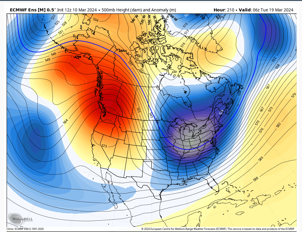
It is becoming quite clear that the high latitude blocking is showing back up again in both the GEFS and EPS. By about March 15th, give or take, we are getting ridging to show up along the WC of Canada. This in turn looks to kick the WC trough out of the SW. Subsequently that ridging evolves such that it appears to take hold along the entire WC of NA, extending all the way up into Alaska and the Arctic, and the trough sets up in the east. This is a strong indicator for a -EPO developing which IMO is prob the most important tele for late season cold air masses and snow chances to affect the NE. On top of that a +PNA is showing up and the AO and NAO will be negative.
I personally get conflicted with late season pushes like this, because my kids are already outdoors for their spring seasons, so standing on a sidelines with sun and 60's beaming down is much more enjoyable then 30's-40's. Anyway here is the look by 12z March 15th and 00z the 19th. Dont be surprised, if this conts to evolve similarly, to St Patty's day give or take, (say 16th-20th), to feature a storm in the NE that threatens with cold and snow potential. To reiterate the bolded above these late season storms always favor the interior, but the coast is not out of it.
We track...at least for a little while longer


_________________
"In weather and in life, there's no winning and losing; there's only winning and learning."
WINTER 2012/2013 TOTALS 43.65"WINTER 2017/2018 TOTALS 62.85" WINTER 2022/2023 TOTALS 4.9"
WINTER 2013/2014 TOTALS 64.85"WINTER 2018/2019 TOTALS 14.25" WINTER 2023/2024 TOTALS 13.1"
WINTER 2014/2015 TOTALS 71.20"WINTER 2019/2020 TOTALS 6.35"
WINTER 2015/2016 TOTALS 35.00"WINTER 2020/2021 TOTALS 37.75"
WINTER 2016/2017 TOTALS 42.25"WINTER 2021/2022 TOTALS 31.65"

sroc4- Admin

- Posts : 8331
Reputation : 301
Join date : 2013-01-07
Location : Wading River, LI
weatherwatchermom and JT33 like this post
Re: Long Range Thread 28.0
![]() by sroc4 Thu Mar 07, 2024 8:17 am
by sroc4 Thu Mar 07, 2024 8:17 am
Caveat: Although the Md and LR MJo forecasts have been pretty miserable in accuracy, the MJO looks to still be in unfavorable phases with amplitude. So my statements above are obviously nowhere near a foregone conclusion.
_________________
"In weather and in life, there's no winning and losing; there's only winning and learning."
WINTER 2012/2013 TOTALS 43.65"WINTER 2017/2018 TOTALS 62.85" WINTER 2022/2023 TOTALS 4.9"
WINTER 2013/2014 TOTALS 64.85"WINTER 2018/2019 TOTALS 14.25" WINTER 2023/2024 TOTALS 13.1"
WINTER 2014/2015 TOTALS 71.20"WINTER 2019/2020 TOTALS 6.35"
WINTER 2015/2016 TOTALS 35.00"WINTER 2020/2021 TOTALS 37.75"
WINTER 2016/2017 TOTALS 42.25"WINTER 2021/2022 TOTALS 31.65"
sroc4- Admin
- Posts : 8331
Reputation : 301
Join date : 2013-01-07
Location : Wading River, LI
Re: Long Range Thread 28.0
![]() by heehaw453 Sun Mar 10, 2024 2:55 pm
by heehaw453 Sun Mar 10, 2024 2:55 pm
So can there be one last gasp of winter as we approach the equinox? I guess so especially NW of I95. IMO it will need a better 50/50 and stronger blocking. The PNA/EPO look good as shown, but I think the Atlantic will have to cooperate more for something decent in latter March. Not to mention any poor placements of the western ridge would be enough to kill it too. I won't say zero chance though for the interior...

heehaw453- Advanced Forecaster

- Posts : 3906
Reputation : 86
Join date : 2014-01-20
Location : Bedminster Township, PA Elevation 600' ASL
Re: Long Range Thread 28.0
![]() by amugs Mon Mar 11, 2024 9:09 am
by amugs Mon Mar 11, 2024 9:09 am
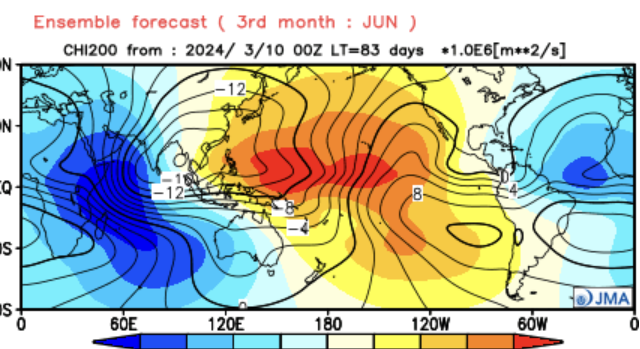
Super Long Range of SST for Summer. That's a strong La Nina Signal which if true with the warm SST in the Hotlantic Main Developement Region could result in a very active hcance season with many near and direct US hits
.png)
_________________
Mugs
AKA:King: Snow Weenie
Self Proclaimed
WINTER 2014-15 : 55.12" +.02 for 6 coatings (avg. 35")
WINTER 2015-16 Total - 29.8" (Avg 35")
WINTER 2016-17 : 39.5" so far

amugs- Advanced Forecaster - Mod

- Posts : 15093
Reputation : 213
Join date : 2013-01-07
Age : 54
Location : Hillsdale,NJ
Re: Long Range Thread 28.0
![]() by amugs Tue Mar 12, 2024 11:54 am
by amugs Tue Mar 12, 2024 11:54 am
From JB at WxBell
And its not just the usual in close storm worry. African wave train should start running
MJO is in 8/1/2
Watch this verify when we needed and it showed this in Oct and Nov for winter!!
And its not just the usual in close storm worry. African wave train should start running
MJO is in 8/1/2
Watch this verify when we needed and it showed this in Oct and Nov for winter!!
_________________
Mugs
AKA:King: Snow Weenie
Self Proclaimed
WINTER 2014-15 : 55.12" +.02 for 6 coatings (avg. 35")
WINTER 2015-16 Total - 29.8" (Avg 35")
WINTER 2016-17 : 39.5" so far
amugs- Advanced Forecaster - Mod
- Posts : 15093
Reputation : 213
Join date : 2013-01-07
Age : 54
Location : Hillsdale,NJ
JT33 likes this post
Page 18 of 18 • 1 ... 10 ... 16, 17, 18
Page 18 of 18
Permissions in this forum:
You cannot reply to topics in this forum|
|
|