Long Range Thread 28.0
+33
weatherwatchermom
essexcountypete
skinsfan1177
aiannone
larryrock72
Coachgriff
DAYBLAZER
nutleyblizzard
hyde345
docstox12
CPcantmeasuresnow
frank 638
Koroptim
HectorO
billg315
dkodgis
MattyICE
toople
sroc4
rb924119
Grselig
crippo84
phil155
Frank_Wx
jmanley32
NJBear
tomsriversnowstorm
Carvin
heehaw453
SENJsnowman
Irish
amugs
richb521
37 posters
Page 3 of 18
Page 3 of 18 •  1, 2, 3, 4 ... 10 ... 18
 Re: Long Range Thread 28.0
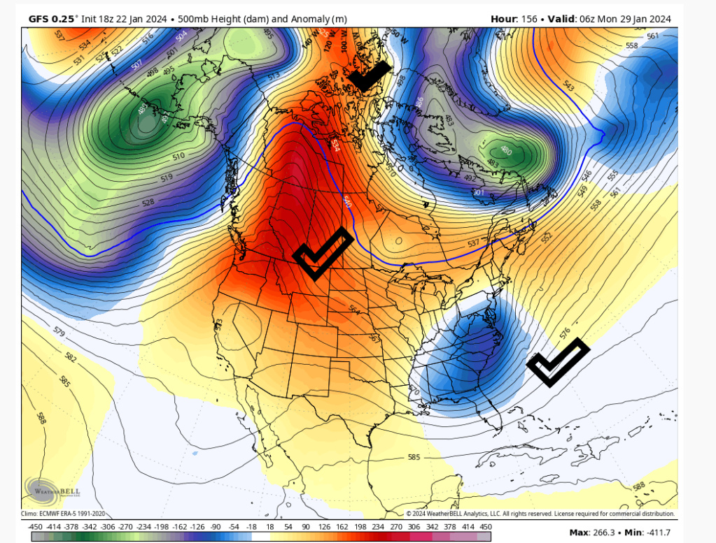
heehaw453 wrote:This is op model GFS 18Z. That's how it snows in January during a marginal long wave pattern. The PNA can overcome quite a bit as the AO is not hostile as shown. NYC and the coastal plain absolutely can have a moderate event with a neutral AO and positive PNA in late January.
The H is coming right out the Yukon compliments of the PNA/AO. We shall see.
Here I was, all ready to step away for a week or two (albeit half-heartedly) for a little set break, when the long range crew basically comes right back on stage, plugs right back in and starts jamming again!
I guess I’m nothing but a tracker. From mid-November to mid-March tracking Wall and Wing (fka winter) storms in the Mid-Atlantic/Northeast is all I know. I might need a 12 step intervention, but yet I’m clearly not ready for that at this time, so I’m just going to track.
 Who’s with me?
SENJsnowman- Senior Enthusiast

- Posts : 1186
Join date : 2017-01-06
kalleg, dkodgis and weatherwatchermom like this post
 Re: Long Range Thread 28.0
heehaw453 wrote:sroc4 wrote:heehaw453 wrote:Confidence is growing a storm is coming on 1/29. Whether it produces snow is probably dependent on the strength/speed of the H to the north and the initial s/w strength. Both are just too far out to have any confidence yet.
Something like 12Z Euro today too strong on the s/w and would be rain as it's too close to coast.
I do like the setup with fast approaching H helping wedge cold air down. Much better than retreating H off the coast.
Yeah Euro seemed to be a Miller B that transferred too late. Timing, position, and orientation of the PNA ridge will be critical as well. Signal is there though
100%. I've seen worse set ups than this produce in peak climo. I'm somewhat optimistic for now because I'm a sucker for banana H.
Ugh. I go weak for banana highs. <3
MattyICE- Advanced Forecaster

- Posts : 249
Join date : 2017-11-10
dkodgis and heehaw453 like this post
 Re: Long Range Thread 28.0
SENJsnowman wrote:heehaw453 wrote:This is op model GFS 18Z. That's how it snows in January during a marginal long wave pattern. The PNA can overcome quite a bit as the AO is not hostile as shown. NYC and the coastal plain absolutely can have a moderate event with a neutral AO and positive PNA in late January.
The H is coming right out the Yukon compliments of the PNA/AO. We shall see.
Here I was, all ready to step away for a week or two (albeit half-heartedly) for a little set break, when the long range crew basically comes right back on stage, plugs right back in and starts jamming again!
I guess I’m nothing but a tracker. From mid-November to mid-March tracking Wall and Wing (fka winter) storms in the Mid-Atlantic/Northeast is all I know. I might need a 12 step intervention, but yet I’m clearly not ready for that at this time, so I’m just going to track.Who’s with me?
We have to see how strong the s/w is and how fast the H moves in. I can tell you if this becomes a traditional Miller B then that favors I90 Corridor for snow. We'd need a solution where the initial s/w is weaker and then transforms to OBX. Any Low that gets to WV on north that is not transitioned to a coastal we're probably toast for any decent snows.
heehaw453- Advanced Forecaster

- Posts : 3906
Reputation : 86
Join date : 2014-01-20
Location : Bedminster Township, PA Elevation 600' ASL
kalleg and SENJsnowman like this post
 Re: Long Range Thread 28.0
Sounds like the proverbial ‘thread the needle’ event. Certainly nothing new around these parts lol. I’ll wade into the tracking with caution and with expectations set accordingly!
SENJsnowman- Senior Enthusiast

- Posts : 1186
Reputation : 61
Join date : 2017-01-06
Age : 51
Location : Bayville, NJ
kalleg, essexcountypete, dkodgis and heehaw453 like this post
 Re: Long Range Thread 28.0
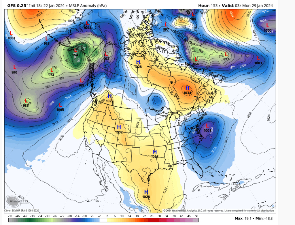
Most guidance today just too far push of the primary L. Transition this 100-150 miles south in KY/TN and there's a shot for an event.
The H becoming stronger and faster which probably would force the s/w to transition sooner and/or the s/w in general less potent. That is how I see a path here. This as is warms things too much IMO. D5 so there is time for changes.
The H becoming stronger and faster which probably would force the s/w to transition sooner and/or the s/w in general less potent. That is how I see a path here. This as is warms things too much IMO. D5 so there is time for changes.

heehaw453- Advanced Forecaster

- Posts : 3906
Reputation : 86
Join date : 2014-01-20
Location : Bedminster Township, PA Elevation 600' ASL
 Re: Long Range Thread 28.0
heehaw453 wrote:Most guidance today just too far push of the primary L. Transition this 100-150 miles south in KY/TN and there's a shot for an event.
The H becoming stronger and faster which probably would force the s/w to transition sooner and/or the s/w in general less potent. That is how I see a path here. This as is warms things too much IMO. D5 so there is time for changes.
Yes but look at how far N and E the primary gets compared to 00z. Huge improvement from one run to the next
_________________
"In weather and in life, there's no winning and losing; there's only winning and learning."
WINTER 2012/2013 TOTALS 43.65"WINTER 2017/2018 TOTALS 62.85" WINTER 2022/2023 TOTALS 4.9"
WINTER 2013/2014 TOTALS 64.85"WINTER 2018/2019 TOTALS 14.25" WINTER 2023/2024 TOTALS 13.1"
WINTER 2014/2015 TOTALS 71.20"WINTER 2019/2020 TOTALS 6.35"
WINTER 2015/2016 TOTALS 35.00"WINTER 2020/2021 TOTALS 37.75"
WINTER 2016/2017 TOTALS 42.25"WINTER 2021/2022 TOTALS 31.65"

sroc4- Admin

- Posts : 8331
Reputation : 301
Join date : 2013-01-07
Location : Wading River, LI
 Re: Long Range Thread 28.0
sroc4 wrote:heehaw453 wrote:Most guidance today just too far push of the primary L. Transition this 100-150 miles south in KY/TN and there's a shot for an event.
The H becoming stronger and faster which probably would force the s/w to transition sooner and/or the s/w in general less potent. That is how I see a path here. This as is warms things too much IMO. D5 so there is time for changes.
Yes but look at how far N and E the primary gets compared to 00z. Huge improvement from one run to the next
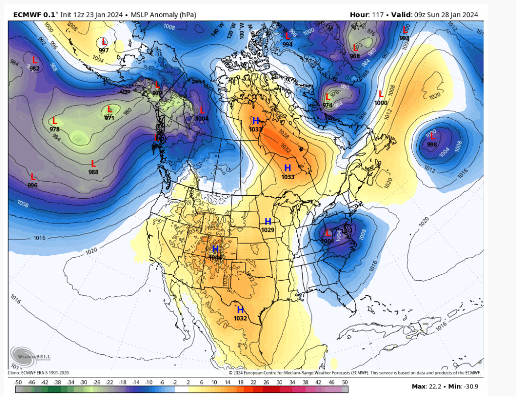
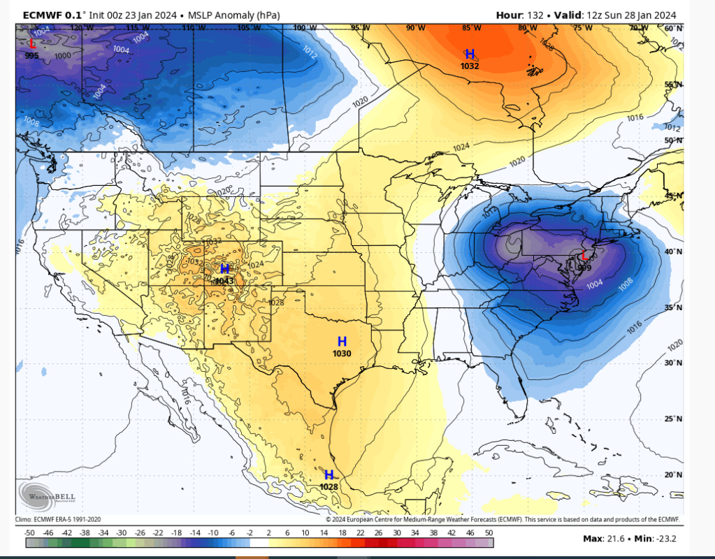
Yes. Note difference in position of the H between 12Z and 00Z. Stronger and further south. I think that's the key with this. With the PNA being as stout as modelled it's not wishful thinking at D5 IMO. D2-3 probably so...
12Z
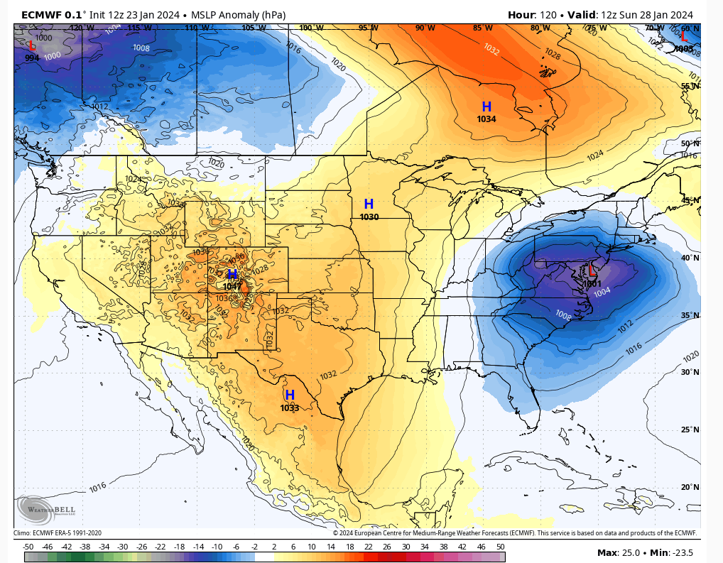
00Z
heehaw453- Advanced Forecaster

- Posts : 3906
Reputation : 86
Join date : 2014-01-20
Location : Bedminster Township, PA Elevation 600' ASL
 Re: Long Range Thread 28.0
The press of the HP is crucial here and I said and we have said .....time n space is everything!
_________________
Mugs
AKA:King: Snow Weenie
Self Proclaimed
WINTER 2014-15 : 55.12" +.02 for 6 coatings (avg. 35")
WINTER 2015-16 Total - 29.8" (Avg 35")
WINTER 2016-17 : 39.5" so far

amugs- Advanced Forecaster - Mod

- Posts : 15093
Reputation : 213
Join date : 2013-01-07
Age : 54
Location : Hillsdale,NJ
CPcantmeasuresnow likes this post
 Re: Long Range Thread 28.0
If I had to loft a guess currently I’d say I-84 and north for significant snow possibilities. Obviously 5 days out changes can still happen as Sroc shows!
MattyICE- Advanced Forecaster

- Posts : 249
Reputation : 6
Join date : 2017-11-10
Age : 38
Location : Clifton, NJ (Eastern Passaic County)
CPcantmeasuresnow likes this post
 Re: Long Range Thread 28.0
MattyICE wrote:If I had to loft a guess currently I’d say I-84 and north for significant snow possibilities. Obviously 5 days out changes can still happen as Sroc shows!
Starting to think I90 on north special. Some guidance is suggesting a closed off ULL in IL and remaining closed as it moves NE. I'm just not seeing good evidence that this storm is going to be weak enough to stay far enough south of the area. There is time for changes, but I'd rather be rooting for a north trend than a south trend. Just think the former is easier with the PNA.
heehaw453- Advanced Forecaster

- Posts : 3906
Reputation : 86
Join date : 2014-01-20
Location : Bedminster Township, PA Elevation 600' ASL
MattyICE likes this post
 Re: Long Range Thread 28.0
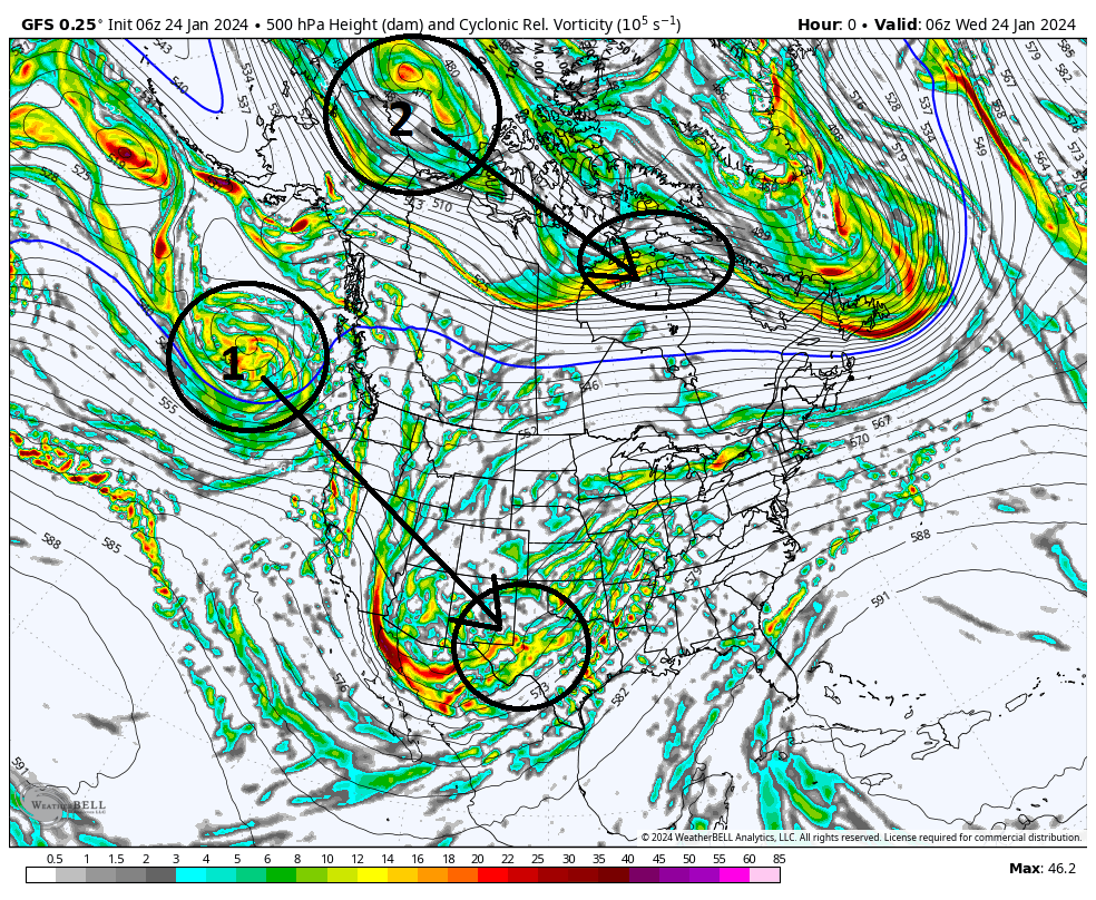
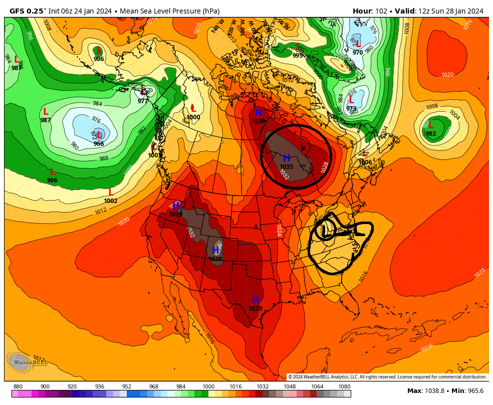
Ok here is the set up for the potential for the28th-30th time frame. As has been stated a few times already, a stout +PNA(ridge along the WC of NA), ridge will give rise to the potential. It cant be stressed enough that this is in the face of an otherwise shitty pattern so alot has to come together just right for it to work out. And work out for whom. Obv the coastal plain has the hardest time with temp profiles, where as off the coast may deal with a subsidence zone. Although keep in mind we all will have to worry about temp profiles to one degree or another.
As of 6z GFS this am here is the two main energies at 500mb (18-20k ft). Labeled 1 & 2. #1 is the energy in the Pac jet which we will call the southern stream (s/s) energy and will give rise to our system, and #2 will create an arctic/polar High Pressure (HP) that will be critical for this set up for providing a cold air source.
As you can see both pieces will dig into these two approx locations by hr 72, approx 3 days from now.
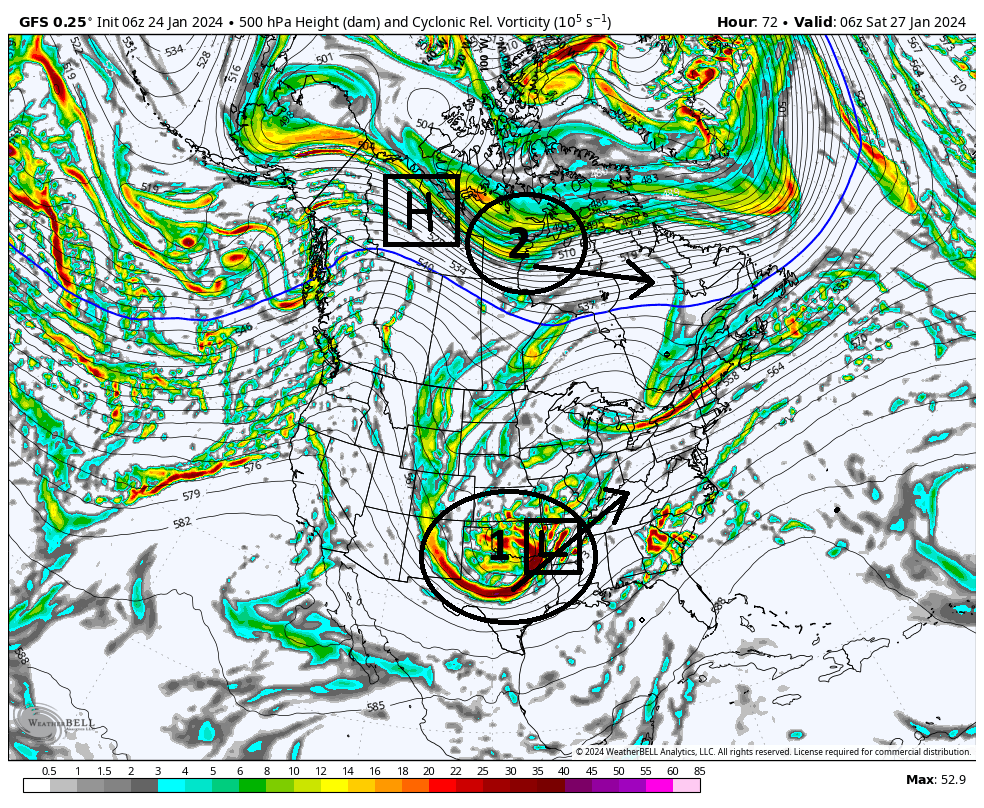
As you can now see in below image the energies are in position. From here 1 & 2 head off in the direction indicated by the arrow.
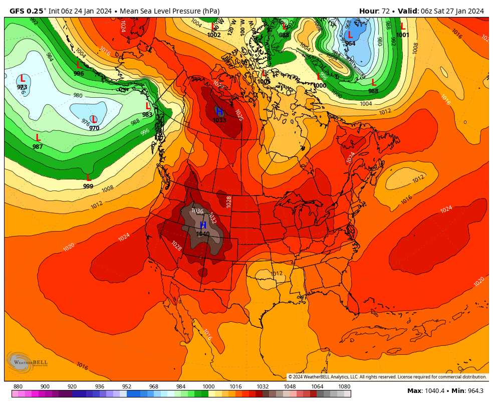
(see below) At the surface, the result of #1 is the development of a surface LP somewhere out ahead of the 500mb energy, and the result of #2 in its position is an HP developing in it's wake.
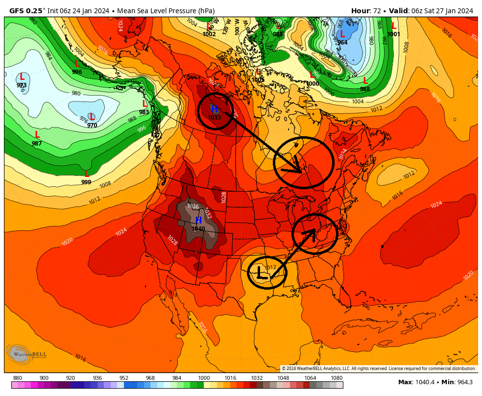
Now quickly look back at the surface map above because this becomes a critical crossroads as we move forward. The surface LP will now heads towards the Ohio/Tenn Valleys, while the HP dives into SE Canada. Simply stated, in essence the overall outcome of this potential will be dictated by the exact timing, strength, and positioning of these two main features. It becomes a race to see who can get into position first, the HP or the LP, to determine how much cold air is available, and when and where.
(Now see below) The primary LP(P LP) will cut towards the Ohio and Tenn valley. In the latest GFS run it takes the P LP north into Western Pa before transferring off the Atlantic coast, and from there the Primary deepens and heads NE.
So to summerize:
1) How strong and How quickly the HP moves in to our north will dictate how far north and west our Primary LP can track before being forced to transfer to the coast.(by the way this is what a Miller B set up is...a cutting primary with a secondary LP transfer to the coast)
AND...
2) How strong and positioning of the HP also tells us how much cold air is available for the system.
CURRENTLY ON THE MODELS: ---Pay attention to HP strength ad placement---
GFS = Cuts furthest north(western PA/E Ohio) before transfer therefore secondary LP too close to the coast and only aeas furthest N&W will be cold enough to snow
CMC = Primary only makes it to W Va before transferring to the coast
Euro = notice its HP position and strength compared to GFS and CMC. Its very late to the party with the HP, but the southern energy takes a more direct route through the eastern Tenn valley, straight to the coast instead of a true Miller B where it cuts west; then transfer of energy to the coast. This will keep the coastal plain warm because of the Antecedent Air mass in place at least per 00z run verbatim.

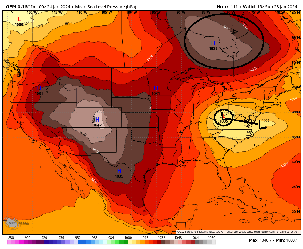

So as you can see there is still much uncertainty in the exact evolution of some of the key players. There are still big picture details that are still unclear. As we all know small changes at 500mb can have large impacts on how the surface features play out. Like pretty much any winter storm, the exact IMBY details will likely not be ironed out until within 24-48hrs.
We Track!
As of 6z GFS this am here is the two main energies at 500mb (18-20k ft). Labeled 1 & 2. #1 is the energy in the Pac jet which we will call the southern stream (s/s) energy and will give rise to our system, and #2 will create an arctic/polar High Pressure (HP) that will be critical for this set up for providing a cold air source.
As you can see both pieces will dig into these two approx locations by hr 72, approx 3 days from now.

As you can now see in below image the energies are in position. From here 1 & 2 head off in the direction indicated by the arrow.

(see below) At the surface, the result of #1 is the development of a surface LP somewhere out ahead of the 500mb energy, and the result of #2 in its position is an HP developing in it's wake.

Now quickly look back at the surface map above because this becomes a critical crossroads as we move forward. The surface LP will now heads towards the Ohio/Tenn Valleys, while the HP dives into SE Canada. Simply stated, in essence the overall outcome of this potential will be dictated by the exact timing, strength, and positioning of these two main features. It becomes a race to see who can get into position first, the HP or the LP, to determine how much cold air is available, and when and where.
(Now see below) The primary LP(P LP) will cut towards the Ohio and Tenn valley. In the latest GFS run it takes the P LP north into Western Pa before transferring off the Atlantic coast, and from there the Primary deepens and heads NE.


So to summerize:
1) How strong and How quickly the HP moves in to our north will dictate how far north and west our Primary LP can track before being forced to transfer to the coast.(by the way this is what a Miller B set up is...a cutting primary with a secondary LP transfer to the coast)
AND...
2) How strong and positioning of the HP also tells us how much cold air is available for the system.
CURRENTLY ON THE MODELS: ---Pay attention to HP strength ad placement---
GFS = Cuts furthest north(western PA/E Ohio) before transfer therefore secondary LP too close to the coast and only aeas furthest N&W will be cold enough to snow
CMC = Primary only makes it to W Va before transferring to the coast
Euro = notice its HP position and strength compared to GFS and CMC. Its very late to the party with the HP, but the southern energy takes a more direct route through the eastern Tenn valley, straight to the coast instead of a true Miller B where it cuts west; then transfer of energy to the coast. This will keep the coastal plain warm because of the Antecedent Air mass in place at least per 00z run verbatim.


So as you can see there is still much uncertainty in the exact evolution of some of the key players. There are still big picture details that are still unclear. As we all know small changes at 500mb can have large impacts on how the surface features play out. Like pretty much any winter storm, the exact IMBY details will likely not be ironed out until within 24-48hrs.
We Track!

_________________
"In weather and in life, there's no winning and losing; there's only winning and learning."
WINTER 2012/2013 TOTALS 43.65"WINTER 2017/2018 TOTALS 62.85" WINTER 2022/2023 TOTALS 4.9"
WINTER 2013/2014 TOTALS 64.85"WINTER 2018/2019 TOTALS 14.25" WINTER 2023/2024 TOTALS 13.1"
WINTER 2014/2015 TOTALS 71.20"WINTER 2019/2020 TOTALS 6.35"
WINTER 2015/2016 TOTALS 35.00"WINTER 2020/2021 TOTALS 37.75"
WINTER 2016/2017 TOTALS 42.25"WINTER 2021/2022 TOTALS 31.65"

sroc4- Admin

- Posts : 8331
Reputation : 301
Join date : 2013-01-07
Location : Wading River, LI
dolphins222, essexcountypete, weatherwatchermom and MattyICE like this post
 Re: Long Range Thread 28.0
Thx for the detailed write-up, Sroc. So, if I'm reading this correctly, most likely no matter how it shakes out, the coast has a high % of an all rain event?

Irish- Pro Enthusiast

- Posts : 788
Reputation : 19
Join date : 2019-01-16
Age : 45
Location : Old Bridge, NJ
 Re: Long Range Thread 28.0
That is how i read it. The ocean is way too warm for this time of year and it is the 800 lb gorilla in the room affecting coastal events when cold air temps are marginal, on the cusp

dkodgis- Senior Enthusiast

- Posts : 2495
Reputation : 98
Join date : 2013-12-29
HectorO and Coachgriff like this post
 Re: Long Range Thread 28.0
With high temps from now through February 7th looking pretty warm, mostly in the mid to upper 40s/lower 50s (Friday being near 60), this is a brutal pattern in what's supposed to be the best time of year for snow. Seems like we'll be halfway through February before we're really even thinking about tracking again.

Irish- Pro Enthusiast

- Posts : 788
Reputation : 19
Join date : 2019-01-16
Age : 45
Location : Old Bridge, NJ
dkodgis likes this post
 Re: Long Range Thread 28.0
How dry I am
How dry I am
How dry I am

dkodgis- Senior Enthusiast

- Posts : 2495
Reputation : 98
Join date : 2013-12-29
kalleg likes this post
 Re: Long Range Thread 28.0
There has been one glaring theme this winter.
The 500mb level is uncooperative. We have not seen a "clean" phase yet this season. The jet streams are disjointed due to all of the short waves cutting off. The storm threat this weekend looks much of the same to me. A pure southern-stream driven event as a bowling ball ULL makes its way to the east coast. The northern jet is nowhere to be found nor seen. It causes temps to be marginal - at best - for coastal plain. Even areas just N&W of NYC wont be THAT cold, and due to lack of energy/phasing, may not even see much snow out of this. This is a very similar pattern to what we experienced in DEC and early JAN.
These are the hard truths:
1. The MJO continues to propagate through unfavorable territories
2. The Stratospheric PV - a phenomena we sometimes rely on to break bad patterns - is actually GAINING strength in the medium to long term. There is no warming event in sight.
Horrible outlooks. I think February might be shot until the 15th or so.
_________________
_______________________________________________________________________________________________________
CLICK HERE to view NJ Strong Snowstorm Classifications
SoulSingMG, MattyICE and Irish like this post
 Re: Long Range Thread 28.0
Frank_Wx wrote:There has been one glaring theme this winter.
The 500mb level is uncooperative. We have not seen a "clean" phase yet this season. The jet streams are disjointed due to all of the short waves cutting off. The storm threat this weekend looks much of the same to me. A pure southern-stream driven event as a bowling ball ULL makes its way to the east coast. The northern jet is nowhere to be found nor seen. It causes temps to be marginal - at best - for coastal plain. Even areas just N&W of NYC wont be THAT cold, and due to lack of energy/phasing, may not even see much snow out of this. This is a very similar pattern to what we experienced in DEC and early JAN.
These are the hard truths:
1. The MJO continues to propagate through unfavorable territories
2. The Stratospheric PV - a phenomena we sometimes rely on to break bad patterns - is actually GAINING strength in the medium to long term. There is no warming event in sight.
Horrible outlooks. I think February might be shot until the 15th or so.
Phasing has been an issue only if it rains of course.
BUT this map is better than the MJO teles and shows by Feb 5/6th we are in phase 8. Now if true the atmosphere should respond in a few days lag with a -EPO and an AO and NAO going negative as well with trough developing over the east coast. Time will tell of course but I trust this map more so than the MJO indies which are all over the place.
.png)
_________________
Mugs
AKA:King: Snow Weenie
Self Proclaimed
WINTER 2014-15 : 55.12" +.02 for 6 coatings (avg. 35")
WINTER 2015-16 Total - 29.8" (Avg 35")
WINTER 2016-17 : 39.5" so far

amugs- Advanced Forecaster - Mod

- Posts : 15093
Reputation : 213
Join date : 2013-01-07
Age : 54
Location : Hillsdale,NJ
kalleg likes this post
 Re: Long Range Thread 28.0
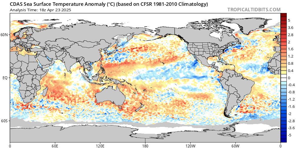
Look at the bottom left of screen and see the tremendous sudden warmth over Eastern Australia Waters. That’s a massive monkey wrench in the cog and predictions for the weather pattern this winter that needs to be investigated. Why did the waters warm so incredibly fast? Summations by some and are valid say underwater volcanoes are to be responsible and JB has a map that shows this.
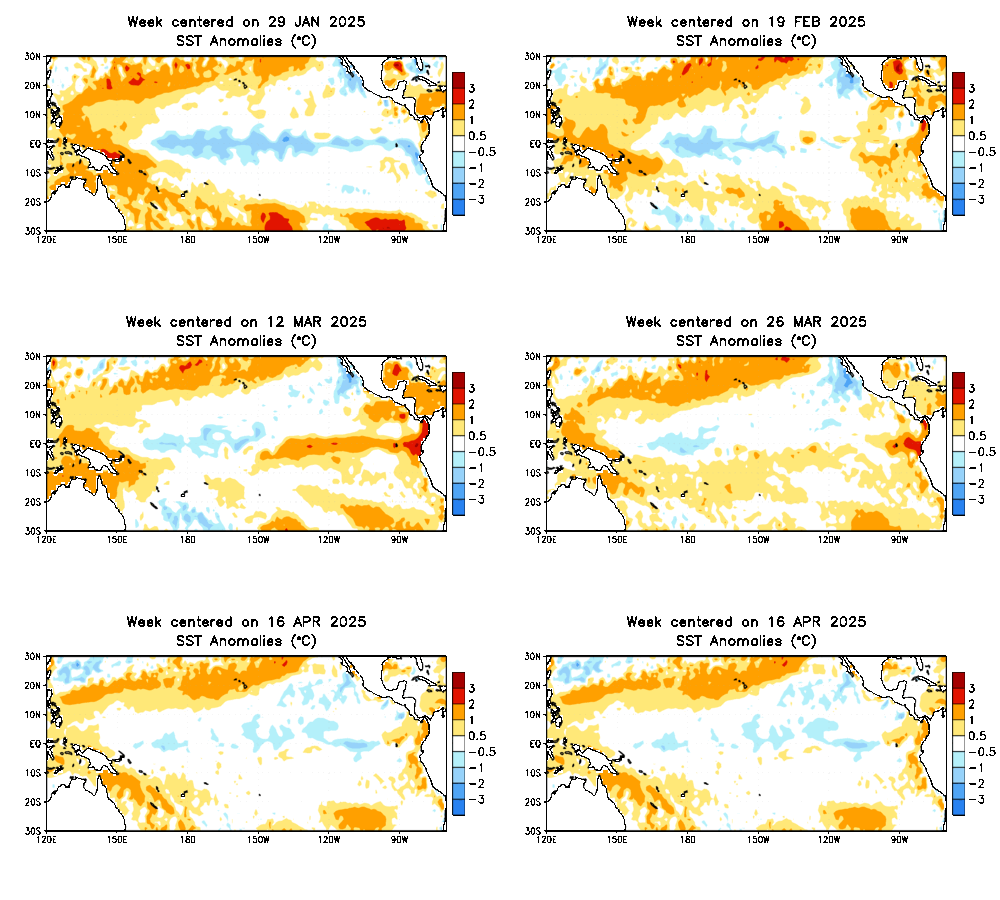
You can also see the Nino weakening and moves west. Only if this was occurring in Sept or Oct. Timing and Space mean everything.
_________________
Mugs
AKA:King: Snow Weenie
Self Proclaimed
WINTER 2014-15 : 55.12" +.02 for 6 coatings (avg. 35")
WINTER 2015-16 Total - 29.8" (Avg 35")
WINTER 2016-17 : 39.5" so far

amugs- Advanced Forecaster - Mod

- Posts : 15093
Reputation : 213
Join date : 2013-01-07
Age : 54
Location : Hillsdale,NJ
 Re: Long Range Thread 28.0
amugs wrote:Frank_Wx wrote:There has been one glaring theme this winter.
The 500mb level is uncooperative. We have not seen a "clean" phase yet this season. The jet streams are disjointed due to all of the short waves cutting off. The storm threat this weekend looks much of the same to me. A pure southern-stream driven event as a bowling ball ULL makes its way to the east coast. The northern jet is nowhere to be found nor seen. It causes temps to be marginal - at best - for coastal plain. Even areas just N&W of NYC wont be THAT cold, and due to lack of energy/phasing, may not even see much snow out of this. This is a very similar pattern to what we experienced in DEC and early JAN.
These are the hard truths:
1. The MJO continues to propagate through unfavorable territories
2. The Stratospheric PV - a phenomena we sometimes rely on to break bad patterns - is actually GAINING strength in the medium to long term. There is no warming event in sight.
Horrible outlooks. I think February might be shot until the 15th or so.
Phasing has been an issue only if it rains of course.
BUT this map is better than the MJO teles and shows by Feb 5/6th we are in phase 8. Now if true the atmosphere should respond in a few days lag with a -EPO and an AO and NAO going negative as well with trough developing over the east coast. Time will tell of course but I trust this map more so than the MJO indies which are all over the place.
Personally I don't necessarily think shutout until mid February. Second week there are hints of more favorable NAM and EPO. If the PNA gets more favorable it'd be really favorable. Of course at this range need to watch for consistency.
heehaw453- Advanced Forecaster

- Posts : 3906
Reputation : 86
Join date : 2014-01-20
Location : Bedminster Township, PA Elevation 600' ASL
 Re: Long Range Thread 28.0
dkodgis wrote:That is how i read it. The ocean is way too warm for this time of year and it is the 800 lb gorilla in the room affecting coastal events when cold air temps are marginal, on the cusp
Actually, the cold weather of the last couple weeks has brought the ocean temps down significantly since December. Currently the ocean water temps off NJ are about 40 degrees, right around -- or maybe in some spots a degree lower -- than normal for this time of year. The ocean temps are always a problem for the immediate coast around here as they're rarely much below 38 degrees, but they shouldn't be playing much of a role at this point anywhere away from the immediate coast - which itself can still do well if the storm takes the right track and is coupled with a sufficiently cold antecedent air mass (which is probably why areas down to the beaches did really well with the snowstorm last week where some shore points in South Jersey had 4-5" of snow right down to the beach).
I don't really think temps have been the culprit this winter. Bigger problem is the storms with a ton of moisture have cut to our west (which almost always means rain for us as that always puts us on the warm side of the storm) and the storms to our south and east have been weak and moisture starved (hence why we did get snow from the last two storms, but paltry amounts).
As Frank alluded, the upper levels need to come together for some of these waves to really pack a punch. Thus far they haven't.

billg315- Advanced Forecaster - Mod

- Posts : 4462
Reputation : 185
Join date : 2015-01-24
Age : 50
Location : Flemington, NJ
dkodgis and SENJsnowman like this post
 Re: Long Range Thread 28.0
amugs wrote:
Look at the bottom left of screen and see the tremendous sudden warmth over Eastern Australia Waters. That’s a massive monkey wrench in the cog and predictions for the weather pattern this winter that needs to be investigated. Why did the waters warm so incredibly fast? Summations by some and are valid say underwater volcanoes are to be responsible and JB has a map that shows this.
You can also see the Nino weakening and moves west. Only if this was occurring in Sept or Oct. Timing and Space mean everything.
Fascinating GIF.
Why does it seems like ocean temps are above normal EVERYWHERE. Good grief
_________________
_______________________________________________________________________________________________________
CLICK HERE to view NJ Strong Snowstorm Classifications
kalleg likes this post
 Re: Long Range Thread 28.0
To sum this up, hardcore winters in our area are a thing of the past. Sure, will we get hit with the oddball storm from time to time, yes. But the winters of 20+ years ago are done. Every year we hear the same garbage- Horrible outlooks, warm noses, warm water temps, crappy MJOs, uncooperative this, uncooperative that, bad PAC, DVD, STP, OPP, etc. We're not down with any of it, but it's our new normal. Time to look to spring and really start shifting our mindsets to the idea that winter isn't really about cold and snow here, rather brief periods of cooler weather and if every star in the universe aligns we might, just might get measurable snow, certainly not 2+ feet!Frank_Wx wrote:There has been one glaring theme this winter.
The 500mb level is uncooperative. We have not seen a "clean" phase yet this season. The jet streams are disjointed due to all of the short waves cutting off. The storm threat this weekend looks much of the same to me. A pure southern-stream driven event as a bowling ball ULL makes its way to the east coast. The northern jet is nowhere to be found nor seen. It causes temps to be marginal - at best - for coastal plain. Even areas just N&W of NYC wont be THAT cold, and due to lack of energy/phasing, may not even see much snow out of this. This is a very similar pattern to what we experienced in DEC and early JAN.
These are the hard truths:
1. The MJO continues to propagate through unfavorable territories
2. The Stratospheric PV - a phenomena we sometimes rely on to break bad patterns - is actually GAINING strength in the medium to long term. There is no warming event in sight.
Horrible outlooks. I think February might be shot until the 15th or so.
When that unicorn does show up, I'll be here to enjoy the journey of tracking it!

Irish- Pro Enthusiast

- Posts : 788
Reputation : 19
Join date : 2019-01-16
Age : 45
Location : Old Bridge, NJ
HectorO likes this post
 Re: Long Range Thread 28.0
Global warming? I know banter.Frank_Wx wrote:amugs wrote:
Look at the bottom left of screen and see the tremendous sudden warmth over Eastern Australia Waters. That’s a massive monkey wrench in the cog and predictions for the weather pattern this winter that needs to be investigated. Why did the waters warm so incredibly fast? Summations by some and are valid say underwater volcanoes are to be responsible and JB has a map that shows this.
You can also see the Nino weakening and moves west. Only if this was occurring in Sept or Oct. Timing and Space mean everything.
Fascinating GIF.
Why does it seems like ocean temps are above normal EVERYWHERE. Good grief

Irish- Pro Enthusiast

- Posts : 788
Reputation : 19
Join date : 2019-01-16
Age : 45
Location : Old Bridge, NJ
Coachgriff likes this post
 Re: Long Range Thread 28.0
Irish wrote:Global warming? I know banter.Frank_Wx wrote:amugs wrote:
Look at the bottom left of screen and see the tremendous sudden warmth over Eastern Australia Waters. That’s a massive monkey wrench in the cog and predictions for the weather pattern this winter that needs to be investigated. Why did the waters warm so incredibly fast? Summations by some and are valid say underwater volcanoes are to be responsible and JB has a map that shows this.
You can also see the Nino weakening and moves west. Only if this was occurring in Sept or Oct. Timing and Space mean everything.
Fascinating GIF.
Why does it seems like ocean temps are above normal EVERYWHERE. Good grief
Def banter
_________________
"In weather and in life, there's no winning and losing; there's only winning and learning."
WINTER 2012/2013 TOTALS 43.65"WINTER 2017/2018 TOTALS 62.85" WINTER 2022/2023 TOTALS 4.9"
WINTER 2013/2014 TOTALS 64.85"WINTER 2018/2019 TOTALS 14.25" WINTER 2023/2024 TOTALS 13.1"
WINTER 2014/2015 TOTALS 71.20"WINTER 2019/2020 TOTALS 6.35"
WINTER 2015/2016 TOTALS 35.00"WINTER 2020/2021 TOTALS 37.75"
WINTER 2016/2017 TOTALS 42.25"WINTER 2021/2022 TOTALS 31.65"

sroc4- Admin

- Posts : 8331
Reputation : 301
Join date : 2013-01-07
Location : Wading River, LI
 Re: Long Range Thread 28.0
sroc4 wrote:Irish wrote:Global warming? I know banter.Frank_Wx wrote:amugs wrote:
Look at the bottom left of screen and see the tremendous sudden warmth over Eastern Australia Waters. That’s a massive monkey wrench in the cog and predictions for the weather pattern this winter that needs to be investigated. Why did the waters warm so incredibly fast? Summations by some and are valid say underwater volcanoes are to be responsible and JB has a map that shows this.
You can also see the Nino weakening and moves west. Only if this was occurring in Sept or Oct. Timing and Space mean everything.
Fascinating GIF.
Why does it seems like ocean temps are above normal EVERYWHERE. Good grief
Def banter
I think judging by the lack of winter the last few years, all the threads will be banter soon. Unless tracking rain is fun.

HectorO- Pro Enthusiast

- Posts : 959
Reputation : 27
Join date : 2013-01-11
 Re: Long Range Thread 28.0
HectorO wrote:sroc4 wrote:Irish wrote:Global warming? I know banter.Frank_Wx wrote:amugs wrote:
Look at the bottom left of screen and see the tremendous sudden warmth over Eastern Australia Waters. That’s a massive monkey wrench in the cog and predictions for the weather pattern this winter that needs to be investigated. Why did the waters warm so incredibly fast? Summations by some and are valid say underwater volcanoes are to be responsible and JB has a map that shows this.
You can also see the Nino weakening and moves west. Only if this was occurring in Sept or Oct. Timing and Space mean everything.
Fascinating GIF.
Why does it seems like ocean temps are above normal EVERYWHERE. Good grief
Def banter
I think judging by the lack of winter the last few years, all the threads will be banter soon. Unless tracking rain is fun.

Irish- Pro Enthusiast

- Posts : 788
Reputation : 19
Join date : 2019-01-16
Age : 45
Location : Old Bridge, NJ
 Re: Long Range Thread 28.0
rb924119 wrote:Frank_Wx wrote:So…uhh I think we may all need to go into hibernation for a couple of weeks based on latest long range projections
I respectfully disagree, Frank. I think that we are going to be in a very active, pseudo-gradient pattern overall starting next week and going through February, and then I think the last week of February through March features an overall better pattern. During the gradient pattern, I think we will be very close to the R/S line, though biased on the cold side.
I’ll elaborate more in the next day or two, but I’m actually kind of optimistic. Gradient patterns can produce in a big way, as long as you’re on the right/cold side of them.
Rb. Any updated thoughts?
heehaw453- Advanced Forecaster

- Posts : 3906
Reputation : 86
Join date : 2014-01-20
Location : Bedminster Township, PA Elevation 600' ASL
Page 3 of 18 •  1, 2, 3, 4 ... 10 ... 18
Page 3 of 18
Permissions in this forum:
You cannot reply to topics in this forum|
|
|

 Home
Home