
 Search
January 11th Rainstorm Observations
Page 1 of 2 • 1, 2 ![]()

January 11th Rainstorm Observations
![]() by Frank_Wx Fri Jan 10, 2014 1:38 pm
by Frank_Wx Fri Jan 10, 2014 1:38 pm
12z RGEM total precip:

Squall line:

12z NAM radar reflectivity


The heaviest rain will come between 4 and 9pm tomorrow night. I think areas will exceed 2 inches of rainfall depending on where the heaviest cells within the squall line set up.
Winds will be between 20-30 mph with gusts greater than 40 mph (50 mph immediate coast and LI).
I could see wind gusts getting as high as 60mph along the immediate coast.
Flooding will be an issue especially for areas in northern NJ in the flood prone zones.
Post observations here.
Last edited by Frank_Wx on Sun Jan 12, 2014 9:56 am; edited 1 time in total
_________________
_______________________________________________________________________________________________________
CLICK HERE to view NJ Strong Snowstorm Classifications

Frank_Wx- Godzilla Seeker

- Posts : 21305
Reputation : 328
Join date : 2013-01-05
Age : 31
Location : Jersey City, NJ -

Re: January 11th Rainstorm Observations
![]() by jmanley32 Fri Jan 10, 2014 1:51 pm
by jmanley32 Fri Jan 10, 2014 1:51 pm

jmanley32- Senior Enthusiast

- Posts : 20516
Reputation : 108
Join date : 2013-12-12
Age : 42
Location : Yonkers, NY
Re: January 11th Rainstorm Observations
![]() by jmanley32 Fri Jan 10, 2014 1:54 pm
by jmanley32 Fri Jan 10, 2014 1:54 pm
jmanley32- Senior Enthusiast
- Posts : 20516
Reputation : 108
Join date : 2013-12-12
Age : 42
Location : Yonkers, NY
Re: January 11th Rainstorm Observations
![]() by Frank_Wx Fri Jan 10, 2014 1:59 pm
by Frank_Wx Fri Jan 10, 2014 1:59 pm
jmanley32 wrote:Ohh sounds like fun in coast CT 60mph possible, will I be expecting the same amount of rain there, The HWO and discussions are basically the same and covered by Upton both here (Yonkers) and there. A squall line do you mean t-storm line or one without thunderstorm charecteristics. I know this is a observation post but was just curious.
There could be thunder associated with this. A squall line has intense winds though with torrential rains. That's why in the scroll on top of the forum, I am saying tomorrow afternoon into the early evening will be the worst since that is when the line is expected to come through.
_________________
_______________________________________________________________________________________________________
CLICK HERE to view NJ Strong Snowstorm Classifications
Frank_Wx- Godzilla Seeker
- Posts : 21305
Reputation : 328
Join date : 2013-01-05
Age : 31
Location : Jersey City, NJ -
Re: January 11th Rainstorm Observations
![]() by jmanley32 Fri Jan 10, 2014 2:28 pm
by jmanley32 Fri Jan 10, 2014 2:28 pm
jmanley32- Senior Enthusiast
- Posts : 20516
Reputation : 108
Join date : 2013-12-12
Age : 42
Location : Yonkers, NY
Re: January 11th Rainstorm Observations
![]() by jmanley32 Fri Jan 10, 2014 4:30 pm
by jmanley32 Fri Jan 10, 2014 4:30 pm
Wind Advisory in effect from noon to 9 PM EST Saturday...
The National Weather Service in New York has issued a Wind
Advisory... which is in effect from noon to 9 PM EST Saturday.
* Locations... New York City... Long Island... southern Middlesex
County and southern New London County.
* Hazards... strong winds.
* Winds... south 15 to 25 mph with gusts 45 to 50 mph.
* Timing... gusts over 45 mph will be possible during the entire
advisory period... but more likely to occur late Saturday
afternoon into early evening.
* Impacts... difficult driving conditions in strong winds.
Precautionary/preparedness actions...
A Wind Advisory is issued when sustained winds of 31 to 39 mph...
or gusts of 46 to 57 mph... are expected or occurring. Winds this
strong can make driving difficult... especially for high profile
vehicles. Use extra caution.
jmanley32- Senior Enthusiast
- Posts : 20516
Reputation : 108
Join date : 2013-12-12
Age : 42
Location : Yonkers, NY
Re: January 11th Rainstorm Observations
![]() by jmanley32 Fri Jan 10, 2014 4:36 pm
by jmanley32 Fri Jan 10, 2014 4:36 pm
jmanley32- Senior Enthusiast
- Posts : 20516
Reputation : 108
Join date : 2013-12-12
Age : 42
Location : Yonkers, NY
Re: January 11th Rainstorm Observations
![]() by Frank_Wx Fri Jan 10, 2014 9:17 pm
by Frank_Wx Fri Jan 10, 2014 9:17 pm

_________________
_______________________________________________________________________________________________________
CLICK HERE to view NJ Strong Snowstorm Classifications
Frank_Wx- Godzilla Seeker
- Posts : 21305
Reputation : 328
Join date : 2013-01-05
Age : 31
Location : Jersey City, NJ -
Re: January 11th Rainstorm Observations
![]() by Frank_Wx Fri Jan 10, 2014 9:20 pm
by Frank_Wx Fri Jan 10, 2014 9:20 pm

_________________
_______________________________________________________________________________________________________
CLICK HERE to view NJ Strong Snowstorm Classifications
Frank_Wx- Godzilla Seeker
- Posts : 21305
Reputation : 328
Join date : 2013-01-05
Age : 31
Location : Jersey City, NJ -
Re: January 11th Rainstorm Observations
![]() by Frank_Wx Fri Jan 10, 2014 9:23 pm
by Frank_Wx Fri Jan 10, 2014 9:23 pm

_________________
_______________________________________________________________________________________________________
CLICK HERE to view NJ Strong Snowstorm Classifications
Frank_Wx- Godzilla Seeker
- Posts : 21305
Reputation : 328
Join date : 2013-01-05
Age : 31
Location : Jersey City, NJ -
Re: January 11th Rainstorm Observations
![]() by jmanley32 Fri Jan 10, 2014 9:27 pm
by jmanley32 Fri Jan 10, 2014 9:27 pm
jmanley32- Senior Enthusiast
- Posts : 20516
Reputation : 108
Join date : 2013-12-12
Age : 42
Location : Yonkers, NY
Re: January 11th Rainstorm Observations
![]() by jmanley32 Fri Jan 10, 2014 9:28 pm
by jmanley32 Fri Jan 10, 2014 9:28 pm
jmanley32- Senior Enthusiast
- Posts : 20516
Reputation : 108
Join date : 2013-12-12
Age : 42
Location : Yonkers, NY
Re: January 11th Rainstorm Observations
![]() by Frank_Wx Fri Jan 10, 2014 9:41 pm
by Frank_Wx Fri Jan 10, 2014 9:41 pm
jmanley32 wrote:Thx for posting the maps, do you think the qpf is low? I have seen higher amounts in other places. DO you expect that wind advisories or warnings will be issued for coastal CT and maybe southern WC?
10M = surface winds.
I've told you many times (and it's in the scroll on top of the forum too) that I think gusts could be over 40 mph with primarily 1-2 inches of rain, but 2+ if you're caught in a strong cell.
_________________
_______________________________________________________________________________________________________
CLICK HERE to view NJ Strong Snowstorm Classifications
Frank_Wx- Godzilla Seeker
- Posts : 21305
Reputation : 328
Join date : 2013-01-05
Age : 31
Location : Jersey City, NJ -
Re: January 11th Rainstorm Observations
![]() by Frank_Wx Fri Jan 10, 2014 9:49 pm
by Frank_Wx Fri Jan 10, 2014 9:49 pm
_________________
_______________________________________________________________________________________________________
CLICK HERE to view NJ Strong Snowstorm Classifications
Frank_Wx- Godzilla Seeker
- Posts : 21305
Reputation : 328
Join date : 2013-01-05
Age : 31
Location : Jersey City, NJ -
Re: January 11th Rainstorm Observations
![]() by jmanley32 Fri Jan 10, 2014 9:52 pm
by jmanley32 Fri Jan 10, 2014 9:52 pm
jmanley32- Senior Enthusiast
- Posts : 20516
Reputation : 108
Join date : 2013-12-12
Age : 42
Location : Yonkers, NY
Re: January 11th Rainstorm Observations
![]() by amugs Sat Jan 11, 2014 8:55 am
by amugs Sat Jan 11, 2014 8:55 am
_________________
Mugs
AKA:King: Snow Weenie
Self Proclaimed
WINTER 2014-15 : 55.12" +.02 for 6 coatings (avg. 35")
WINTER 2015-16 Total - 29.8" (Avg 35")
WINTER 2016-17 : 39.5" so far

amugs- Advanced Forecaster - Mod

- Posts : 15093
Reputation : 213
Join date : 2013-01-07
Age : 54
Location : Hillsdale,NJ
Re: January 11th Rainstorm Observations
![]() by jmanley32 Sat Jan 11, 2014 11:39 am
by jmanley32 Sat Jan 11, 2014 11:39 am
jmanley32- Senior Enthusiast
- Posts : 20516
Reputation : 108
Join date : 2013-12-12
Age : 42
Location : Yonkers, NY
Re: January 11th Rainstorm Observations
![]() by amugs Sat Jan 11, 2014 12:33 pm
by amugs Sat Jan 11, 2014 12:33 pm
BLAHHHHH looks like March out there today - waiting for this pattern to reload as the maps/models are showing and get back to some good ol' fashion winter cold and snow!!
_________________
Mugs
AKA:King: Snow Weenie
Self Proclaimed
WINTER 2014-15 : 55.12" +.02 for 6 coatings (avg. 35")
WINTER 2015-16 Total - 29.8" (Avg 35")
WINTER 2016-17 : 39.5" so far
amugs- Advanced Forecaster - Mod
- Posts : 15093
Reputation : 213
Join date : 2013-01-07
Age : 54
Location : Hillsdale,NJ
Re: January 11th Rainstorm Observations
![]() by Sferra01 Sat Jan 11, 2014 2:03 pm
by Sferra01 Sat Jan 11, 2014 2:03 pm
Sferra01- Posts : 46
Reputation : 0
Join date : 2013-01-13
Location : Kings Park, NY
Re: January 11th Rainstorm Observations
![]() by jmanley32 Sat Jan 11, 2014 4:14 pm
by jmanley32 Sat Jan 11, 2014 4:14 pm
jmanley32- Senior Enthusiast
- Posts : 20516
Reputation : 108
Join date : 2013-12-12
Age : 42
Location : Yonkers, NY
Re: January 11th Rainstorm Observations
![]() by CPcantmeasuresnow Sat Jan 11, 2014 4:19 pm
by CPcantmeasuresnow Sat Jan 11, 2014 4:19 pm

CPcantmeasuresnow- Wx Statistician Guru

- Posts : 7274
Reputation : 230
Join date : 2013-01-07
Age : 103
Location : Eastern Orange County, NY
Re: January 11th Rainstorm Observations
![]() by Dunnzoo Sat Jan 11, 2014 4:44 pm
by Dunnzoo Sat Jan 11, 2014 4:44 pm
_________________
Janet
Snowfall winter of 2023-2024 17.5"
Snowfall winter of 2022-2023 6.0"
Snowfall winter of 2021-2022 17.6" 1" sleet 2/25/22
Snowfall winter of 2020-2021 51.1"
Snowfall winter of 2019-2020 8.5"
Snowfall winter of 2018-2019 25.1"
Snowfall winter of 2017-2018 51.9"
Snowfall winter of 2016-2017 45.6"
Snowfall winter of 2015-2016 29.5"
Snowfall winter of 2014-2015 50.55"
Snowfall winter of 2013-2014 66.5"

Dunnzoo- Senior Enthusiast - Mod
- Posts : 4891
Reputation : 68
Join date : 2013-01-11
Age : 62
Location : Westwood, NJ
Re: January 11th Rainstorm Observations
![]() by amugs Sat Jan 11, 2014 5:44 pm
by amugs Sat Jan 11, 2014 5:44 pm
Dunnzoo wrote:Squall line deflated in northern NJ, the black hole strikes again mugs!
I know - but the fog is crazy - driving from Allendale to Hillsdale took me 1/2 hour for a 15 minute drive!!
_________________
Mugs
AKA:King: Snow Weenie
Self Proclaimed
WINTER 2014-15 : 55.12" +.02 for 6 coatings (avg. 35")
WINTER 2015-16 Total - 29.8" (Avg 35")
WINTER 2016-17 : 39.5" so far
amugs- Advanced Forecaster - Mod
- Posts : 15093
Reputation : 213
Join date : 2013-01-07
Age : 54
Location : Hillsdale,NJ
Re: January 11th Rainstorm Observations
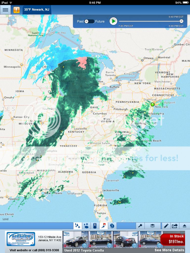
![]() by Frank_Wx Sat Jan 11, 2014 7:24 pm
by Frank_Wx Sat Jan 11, 2014 7:24 pm
_________________
_______________________________________________________________________________________________________
CLICK HERE to view NJ Strong Snowstorm Classifications
Frank_Wx- Godzilla Seeker
- Posts : 21305
Reputation : 328
Join date : 2013-01-05
Age : 31
Location : Jersey City, NJ -
Re: January 11th Rainstorm Observations
![]() by SNOW MAN Sun Jan 12, 2014 7:04 am
by SNOW MAN Sun Jan 12, 2014 7:04 am

SNOW MAN- Senior Enthusiast
- Posts : 1361
Reputation : 25
Join date : 2013-01-13
Age : 64
Location : Marshalls Creek Pa.
Page 1 of 2 • 1, 2 ![]()
|
|
|