
 Search
2/2 to 2/3 Light Snow Event/Observations Thread
5 posters

2/2 to 2/3 Light Snow Event/Observations Thread
![]() by Frank_Wx Thu Jan 31, 2013 11:08 am
by Frank_Wx Thu Jan 31, 2013 11:08 am
The NAM has about 1-3 inches for the area. 12z GFS was close to a big storm. Keep an eye on this one...
Last edited by Frank_Wx on Sat Feb 02, 2013 6:49 pm; edited 2 times in total

Frank_Wx- Godzilla Seeker

- Posts : 21305
Reputation : 328
Join date : 2013-01-05
Age : 31
Location : Jersey City, NJ -

Re: 2/2 to 2/3 Light Snow Event/Observations Thread
![]() by sroc4 Thu Jan 31, 2013 11:14 am
by sroc4 Thu Jan 31, 2013 11:14 am
Oh stop it 12z GFS. Why you be playin with me like that?
_________________
"In weather and in life, there's no winning and losing; there's only winning and learning."
WINTER 2012/2013 TOTALS 43.65"WINTER 2017/2018 TOTALS 62.85" WINTER 2022/2023 TOTALS 4.9"
WINTER 2013/2014 TOTALS 64.85"WINTER 2018/2019 TOTALS 14.25" WINTER 2023/2024 TOTALS 13.1"
WINTER 2014/2015 TOTALS 71.20"WINTER 2019/2020 TOTALS 6.35"
WINTER 2015/2016 TOTALS 35.00"WINTER 2020/2021 TOTALS 37.75"
WINTER 2016/2017 TOTALS 42.25"WINTER 2021/2022 TOTALS 31.65"

sroc4- Admin
- Posts : 8331
Reputation : 301
Join date : 2013-01-07
Location : Wading River, LI
Re: 2/2 to 2/3 Light Snow Event/Observations Thread
![]() by amugs Thu Jan 31, 2013 4:24 pm
by amugs Thu Jan 31, 2013 4:24 pm
Seems to be the winter of 1-3" storms with close calls - I hope we fianlly get one-big storm that is and it happens on a work day so we can get off from school 
Last edited by amugs on Thu Jan 31, 2013 5:21 pm; edited 1 time in total

amugs- Advanced Forecaster - Mod

- Posts : 15093
Reputation : 213
Join date : 2013-01-07
Age : 54
Location : Hillsdale,NJ
Re: 2/2 to 2/3 Light Snow Event/Observations Thread
![]() by Math23x7 Thu Jan 31, 2013 5:08 pm
by Math23x7 Thu Jan 31, 2013 5:08 pm
amugs wrote:Seems to be teh winter of 1-3" storms with close calls - I hope we fianlly get one-big storm that is and it happens on a work day so we can get off from school
Be careful of what you wish for Amugs. Recall that most schools were closed for at least a week as a result of Hurricane Sandy, extending their school year. The last thing they need now is snow days at this point. I would much rather have it on a weekend.
Math23x7- Wx Statistician Guru

- Posts : 2379
Reputation : 68
Join date : 2013-01-08
Re: 2/2 to 2/3 Light Snow Event/Observations Thread
![]() by amugs Thu Jan 31, 2013 5:21 pm
by amugs Thu Jan 31, 2013 5:21 pm
Math - almost all schools in NJ have done what we did by extending our school year to June 27th due to Sandy and rebuilt in 3 snow/emergency days. So if we get a day here or there we have them to use once again. I have been a teache for 20+ years and the only other time we had this situation was in 1993-94 and 1995-96 but both of those years were due to snow closings. We shall see........
amugs- Advanced Forecaster - Mod
- Posts : 15093
Reputation : 213
Join date : 2013-01-07
Age : 54
Location : Hillsdale,NJ
Re: 2/2 to 2/3 Light Snow Event/Observations Thread
![]() by Snow88 Fri Feb 01, 2013 9:05 am
by Snow88 Fri Feb 01, 2013 9:05 am
12z ARW has .25+ for the NYC area
http://www.meteo.psu.edu/~fxg1/RSMEAST_12z/rsmloop.html
http://www.meteo.psu.edu/~fxg1/RSMEAST_12z/rsmloop.html

Snow88- Senior Enthusiast

- Posts : 2193
Reputation : 4
Join date : 2013-01-09
Age : 35
Location : Brooklyn, NY
Re: 2/2 to 2/3 Light Snow Event/Observations Thread
![]() by Frank_Wx Fri Feb 01, 2013 9:46 am
by Frank_Wx Fri Feb 01, 2013 9:46 am

Latest NAM qpf is nice for NYC Metro. Looks like a norlun trough will set up for this system
Frank_Wx- Godzilla Seeker
- Posts : 21305
Reputation : 328
Join date : 2013-01-05
Age : 31
Location : Jersey City, NJ -
Re: 2/2 to 2/3 Light Snow Event/Observations Thread
![]() by amugs Fri Feb 01, 2013 12:52 pm
by amugs Fri Feb 01, 2013 12:52 pm
Frank, from the maps would you say we are looking at about 2-4" in NNJ ? Want to get an idea since I am heading ver to freinds house in Westchester Co.,NY to watch the game Sunday?
ALso, thoughts on Tuesday storm - or is going to be a 1-3" event like we have basicall had this whole winter. The winter of almost.....
ALso, thoughts on Tuesday storm - or is going to be a 1-3" event like we have basicall had this whole winter. The winter of almost.....
amugs- Advanced Forecaster - Mod
- Posts : 15093
Reputation : 213
Join date : 2013-01-07
Age : 54
Location : Hillsdale,NJ
Re: 2/2 to 2/3 Light Snow Event/Observations Thread
![]() by Snow88 Fri Feb 01, 2013 1:06 pm
by Snow88 Fri Feb 01, 2013 1:06 pm
Euro has very little precip now. It lost the norlun signature that it showed in the past runs. This threat is starting to go downhill like the other threats this winter
Snow88- Senior Enthusiast
- Posts : 2193
Reputation : 4
Join date : 2013-01-09
Age : 35
Location : Brooklyn, NY
Re: 2/2 to 2/3 Light Snow Event/Observations Thread
![]() by sroc4 Fri Feb 01, 2013 4:46 pm
by sroc4 Fri Feb 01, 2013 4:46 pm
Latest NWS Upton discussion on Sunday snow..interesting.
SO...MAINLY LOOKING AT A LIGHT SNOW EVENT FOR THE REGION SAT NIGHT
INTO SUNDAY EVENING. LOW TRACK AND COLD AIRMASS IN PLACE ARE
POINTING TO AN ALL SNOW EVENT. INITIALLY WEAK OVERRUNNING AHEAD OF THE
BROAD WEAK LOW LATE SAT NIGHT INTO SUN MORNING SHOULD GENERATE SOME
LIGHT SNOW ACROSS THE REGION (UP TO AN INCH OR SO)...WITH MANY TIMES
FAR SE AREAS SEEING THE MOST ACTIVITY AS THE SYSTEM TAPS INTO
ATLANTIC MOISTURE. THEN CONVERGENCE OF PERIPHERAL MOISTURE WRAPPING
IN ON THE NW PERIPHERY OF LOW...AHEAD OF/ALONG THE APPROACHING COLD
FRONT/INVERTED TROUGH AXIS...INTERACTING WITH APPROACHING SHORTWAVE
LIFT/INSTABILITY WILL PRESENT THE THREAT FOR SOME BRIEF MODERATE TO
HEAVY SNOW BANDING SUN AFTERNOON/EVENING. INHERENT UNCERTAINTY
EXISTS IN PLACEMENT OF THESE TYPE OF MESOSCALE AND INSTABILITY DRIVEN
FEATURES. DEPENDING ON WHERE ALL THIS COME TOGETHER THERE IS
POTENTIAL FOR PORTIONS OF THE AREA TO SEE LITTLE IF ANY ADDITIONAL
SNOW...OR PORTIONS OF THE REGION SEEING UP TO 2 TO 4 ADDITIONAL
INCHES OF SNOW. THIS VARIANCE IS ILLUSTRATED BY THE SPREAD IN
ENSEMBLE MEMBERS WITH QPF/SNOW. WITH THIS UNCERTAINTY WILL MAINTAIN
A GENERAL 1 TO 2 INCH SNOWFALL...WITH SOME CONFIDENCE IN HIGHER
AMOUNTS ACROSS SE ZONES WITH LIKELY MORE MOISTURE TO WORK WITH.
Lee Goldberg just semi agreed with this saying a general coating to 2" with a few isolated spots a bit higher. I personally have been scorned by the boy who cried snow in the past so will be happy with an inch and greatful for more.
_________________
"In weather and in life, there's no winning and losing; there's only winning and learning."
WINTER 2012/2013 TOTALS 43.65"WINTER 2017/2018 TOTALS 62.85" WINTER 2022/2023 TOTALS 4.9"
WINTER 2013/2014 TOTALS 64.85"WINTER 2018/2019 TOTALS 14.25" WINTER 2023/2024 TOTALS 13.1"
WINTER 2014/2015 TOTALS 71.20"WINTER 2019/2020 TOTALS 6.35"
WINTER 2015/2016 TOTALS 35.00"WINTER 2020/2021 TOTALS 37.75"
WINTER 2016/2017 TOTALS 42.25"WINTER 2021/2022 TOTALS 31.65"
sroc4- Admin
- Posts : 8331
Reputation : 301
Join date : 2013-01-07
Location : Wading River, LI
Re: 2/2 to 2/3 Light Snow Event/Observations Thread
![]() by Frank_Wx Fri Feb 01, 2013 6:45 pm
by Frank_Wx Fri Feb 01, 2013 6:45 pm
Models backed off significantly on this storm. Its just that type of winter...expect snow showers. Coating to an inch possible.
Frank_Wx- Godzilla Seeker
- Posts : 21305
Reputation : 328
Join date : 2013-01-05
Age : 31
Location : Jersey City, NJ -
Re: 2/2 to 2/3 Light Snow Event/Observations Thread
![]() by sroc4 Fri Feb 01, 2013 7:27 pm
by sroc4 Fri Feb 01, 2013 7:27 pm
http://www.erh.noaa.gov/er/okx/stormtotalprecip.php
_________________
"In weather and in life, there's no winning and losing; there's only winning and learning."
WINTER 2012/2013 TOTALS 43.65"WINTER 2017/2018 TOTALS 62.85" WINTER 2022/2023 TOTALS 4.9"
WINTER 2013/2014 TOTALS 64.85"WINTER 2018/2019 TOTALS 14.25" WINTER 2023/2024 TOTALS 13.1"
WINTER 2014/2015 TOTALS 71.20"WINTER 2019/2020 TOTALS 6.35"
WINTER 2015/2016 TOTALS 35.00"WINTER 2020/2021 TOTALS 37.75"
WINTER 2016/2017 TOTALS 42.25"WINTER 2021/2022 TOTALS 31.65"
sroc4- Admin
- Posts : 8331
Reputation : 301
Join date : 2013-01-07
Location : Wading River, LI
Re: 2/2 to 2/3 Light Snow Event/Observations Thread
![]() by Frank_Wx Sat Feb 02, 2013 1:32 am
by Frank_Wx Sat Feb 02, 2013 1:32 am
SNOW MAP
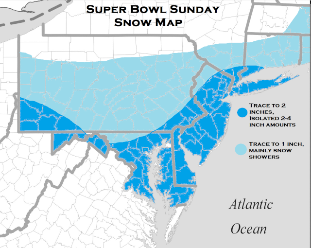
I am going a little bullish here. I like how the primary vort is digging into the trough. There will be an inverted trough setting up somewhere and I feel areas will see isolated 2+ inch amounts around our area. We will see what happens. I have a gut feeling on this one. Current radar looks nice as well.
I am going a little bullish here. I like how the primary vort is digging into the trough. There will be an inverted trough setting up somewhere and I feel areas will see isolated 2+ inch amounts around our area. We will see what happens. I have a gut feeling on this one. Current radar looks nice as well.
Frank_Wx- Godzilla Seeker
- Posts : 21305
Reputation : 328
Join date : 2013-01-05
Age : 31
Location : Jersey City, NJ -
Re: 2/2 to 2/3 Light Snow Event/Observations Thread
![]() by sroc4 Sat Feb 02, 2013 6:32 am
by sroc4 Sat Feb 02, 2013 6:32 am
I can agree with this Frank. A surprise inch or two would be nice.
_________________
"In weather and in life, there's no winning and losing; there's only winning and learning."
WINTER 2012/2013 TOTALS 43.65"WINTER 2017/2018 TOTALS 62.85" WINTER 2022/2023 TOTALS 4.9"
WINTER 2013/2014 TOTALS 64.85"WINTER 2018/2019 TOTALS 14.25" WINTER 2023/2024 TOTALS 13.1"
WINTER 2014/2015 TOTALS 71.20"WINTER 2019/2020 TOTALS 6.35"
WINTER 2015/2016 TOTALS 35.00"WINTER 2020/2021 TOTALS 37.75"
WINTER 2016/2017 TOTALS 42.25"WINTER 2021/2022 TOTALS 31.65"
sroc4- Admin
- Posts : 8331
Reputation : 301
Join date : 2013-01-07
Location : Wading River, LI
Re: 2/2 to 2/3 Light Snow Event/Observations Thread
![]() by Snow88 Sat Feb 02, 2013 4:53 pm
by Snow88 Sat Feb 02, 2013 4:53 pm
18z RGEM has the norlun trough right over NYC. Really nice for the NYC area.

Snow88- Senior Enthusiast
- Posts : 2193
Reputation : 4
Join date : 2013-01-09
Age : 35
Location : Brooklyn, NY
Re: 2/2 to 2/3 Light Snow Event/Observations Thread
![]() by Frank_Wx Sat Feb 02, 2013 6:48 pm
by Frank_Wx Sat Feb 02, 2013 6:48 pm
Light snow beginning to break out in west NJ 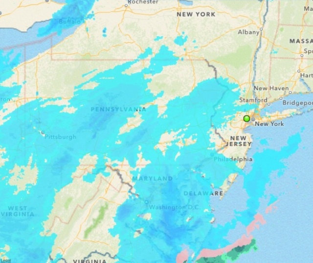
Frank_Wx- Godzilla Seeker
- Posts : 21305
Reputation : 328
Join date : 2013-01-05
Age : 31
Location : Jersey City, NJ -
Re: 2/2 to 2/3 Light Snow Event/Observations Thread
![]() by Frank_Wx Sat Feb 02, 2013 7:49 pm
by Frank_Wx Sat Feb 02, 2013 7:49 pm
Flurries!!!!!
Frank_Wx- Godzilla Seeker
- Posts : 21305
Reputation : 328
Join date : 2013-01-05
Age : 31
Location : Jersey City, NJ -
Re: 2/2 to 2/3 Light Snow Event/Observations Thread
![]() by amugs Sat Feb 02, 2013 9:03 pm
by amugs Sat Feb 02, 2013 9:03 pm
Light snow up here in NNJ - Hillsdale, Bergen County. A nice 2 or possibly 3" would be good. Ground is coated.
Is there any word on the 5/6th storm or is it off the maps/ots? Just checking.
Is there any word on the 5/6th storm or is it off the maps/ots? Just checking.
amugs- Advanced Forecaster - Mod
- Posts : 15093
Reputation : 213
Join date : 2013-01-07
Age : 54
Location : Hillsdale,NJ
Re: 2/2 to 2/3 Light Snow Event/Observations Thread
![]() by Frank_Wx Sat Feb 02, 2013 10:30 pm
by Frank_Wx Sat Feb 02, 2013 10:30 pm
amugs wrote:Light snow up here in NNJ - Hillsdale, Bergen County. A nice 2 or possibly 3" would be good. Ground is coated.
Is there any word on the 5/6th storm or is it off the maps/ots? Just checking.
I think southern NJ does better than us. Coating to an inch looks good.
Frank_Wx- Godzilla Seeker
- Posts : 21305
Reputation : 328
Join date : 2013-01-05
Age : 31
Location : Jersey City, NJ -
Permissions in this forum:
You cannot reply to topics in this forum|
|
|