
 Search
March 17th-18th Storm Potential Discussion
Page 10 of 21 •  1 ... 6 ... 9, 10, 11 ... 15 ... 21
 ![]()
Re: March 17th-18th Storm Potential Discussion
![]() by NjWeatherGuy Fri Mar 14, 2014 6:47 am
by NjWeatherGuy Fri Mar 14, 2014 6:47 am
NjWeatherGuy- Advanced Forecaster

- Posts : 4100
Join date : 2013-01-06
Re: March 17th-18th Storm Potential Discussion
![]() by pdubz Fri Mar 14, 2014 6:50 am
by pdubz Fri Mar 14, 2014 6:50 am
pdubz- Pro Enthusiast

- Posts : 539
Join date : 2013-09-24
Re: March 17th-18th Storm Potential Discussion
![]() by NjWeatherGuy Fri Mar 14, 2014 6:54 am
by NjWeatherGuy Fri Mar 14, 2014 6:54 am
pdubz wrote:Today's runs are important if we want to lock it in tomorrow night
Right, look at trends, not individual maps, NAM/SREFs have consistently showed a great solution but it's in their long range so I wouldn't put much stock in it. The EURO and GFS have been stubborn on a much weaker system, we still get precip but it's like a 2-5" type deal with light overrunning precip, CMC continues to waffle a bit but has showed a decent storm here for a while. Now, question is will the GFS/EURO win out or are the NAM/SREF/CMC camp more likely? Right now I'd bank on the side of the GFS/EURO and bet on a moderate system, the NAM/SREFs have a bias in this range to do this but will be able to be taken more seriously tomorrow if trends hold. We'll see....

NjWeatherGuy- Advanced Forecaster
- Posts : 4100
Reputation : 28
Join date : 2013-01-06
Location : Belle Mead, NJ
Re: March 17th-18th Storm Potential Discussion
![]() by pdubz Fri Mar 14, 2014 6:59 am
by pdubz Fri Mar 14, 2014 6:59 am
NjWeatherGuy wrote:pdubz wrote:Today's runs are important if we want to lock it in tomorrow night
Right, look at trends, not individual maps, NAM/SREFs have consistently showed a great solution but it's in their long range so I wouldn't put much stock in it. The EURO and GFS have been stubborn on a much weaker system, we still get precip but it's like a 2-5" type deal with light overrunning precip, CMC continues to waffle a bit but has showed a decent storm here for a while. Now, question is will the GFS/EURO win out or are the NAM/SREF/CMC camp more likely? Right now I'd bank on the side of the GFS/EURO and bet on a moderate system, the NAM/SREFs have a bias in this range to do this but will be able to be taken more seriously tomorrow if trends hold. We'll see....
Exactly just a waiting game now

pdubz- Pro Enthusiast
- Posts : 539
Reputation : 0
Join date : 2013-09-24
Age : 32
Location : Port Washington,NY (L.I)
Re: March 17th-18th Storm Potential Discussion
![]() by pdubz Fri Mar 14, 2014 7:02 am
by pdubz Fri Mar 14, 2014 7:02 am
I would imagine they wouldn't like flip floping when planning a mission.
pdubz- Pro Enthusiast
- Posts : 539
Reputation : 0
Join date : 2013-09-24
Age : 32
Location : Port Washington,NY (L.I)
Re: March 17th-18th Storm Potential Discussion
![]() by jmanley32 Fri Mar 14, 2014 7:09 am
by jmanley32 Fri Mar 14, 2014 7:09 am

jmanley32- Senior Enthusiast

- Posts : 20516
Reputation : 108
Join date : 2013-12-12
Age : 42
Location : Yonkers, NY
Re: March 17th-18th Storm Potential Discussion
![]() by sroc4 Fri Mar 14, 2014 7:11 am
by sroc4 Fri Mar 14, 2014 7:11 am
Come Sunday, as you can see, the northern and southern energy are coming together nicely.
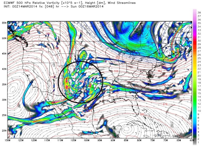 " />
" />By the time we get to Monday; however, the Euro is holding back energy. It essentially strings out all the energy from SW to NE exiting through the gulf of Mex all the way into Mexico. I think its doing this because the ridge seems to be pushed southward secondary to the energy that is coming ashore in the far NW CONUS. As a result of the ridge sinking south it drags with it some of the energy linked too it on its SE flank. The ridge sinking south is showing up a little on other models. Not sure if its truly significant or not.
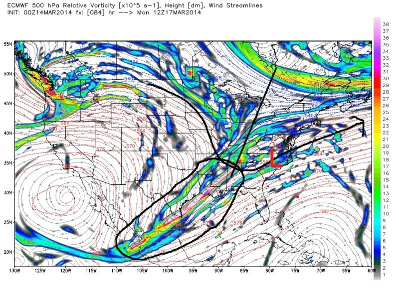 " />
" />As a result of the strung out energy, this keeps the trough positively tilted so when the LP develops its track is forced off Hatteras and OTS leaving us on the northern fringe of the precip.
 " />
" />If I am not mistaken one of the Euro Models biases is to hold back energy, so I expect it to correct bringing more of the energy back into the base of the trough over the next few runs and tick north. By doing this the trough axis will be forced more neutral and a better track up the coast ensues as a result. That being said that is no guarantee by any means.
I still feel like I see some of the other models still trying to hold back some energy but instead of over the SW CONUS and N Mexico like it was showing a day or two ago it looks like its trying to do it to a lesser degree nearer the GOM. This may be too little to late meaning we already have our storm but we shall see. PV looks to be cooperating pretty well in its strength and position (for the moment) on most if not all major models). Again I will jump on no train until Sunday morning. Today and tonight begins the home stretch as the energy begins to enter better sampling regions.
The Cautious Optimism must continue.
_________________
"In weather and in life, there's no winning and losing; there's only winning and learning."
WINTER 2012/2013 TOTALS 43.65"WINTER 2017/2018 TOTALS 62.85" WINTER 2022/2023 TOTALS 4.9"
WINTER 2013/2014 TOTALS 64.85"WINTER 2018/2019 TOTALS 14.25" WINTER 2023/2024 TOTALS 13.1"
WINTER 2014/2015 TOTALS 71.20"WINTER 2019/2020 TOTALS 6.35"
WINTER 2015/2016 TOTALS 35.00"WINTER 2020/2021 TOTALS 37.75"
WINTER 2016/2017 TOTALS 42.25"WINTER 2021/2022 TOTALS 31.65"

sroc4- Admin

- Posts : 8331
Reputation : 301
Join date : 2013-01-07
Location : Wading River, LI
Re: March 17th-18th Storm Potential Discussion
![]() by CPcantmeasuresnow Fri Mar 14, 2014 7:47 am
by CPcantmeasuresnow Fri Mar 14, 2014 7:47 am
NjWeatherGuy wrote:pdubz wrote:Today's runs are important if we want to lock it in tomorrow night
Right, look at trends, not individual maps, NAM/SREFs have consistently showed a great solution but it's in their long range so I wouldn't put much stock in it. The EURO and GFS have been stubborn on a much weaker system, we still get precip but it's like a 2-5" type deal with light overrunning precip, CMC continues to waffle a bit but has showed a decent storm here for a while. Now, question is will the GFS/EURO win out or are the NAM/SREF/CMC camp more likely? Right now I'd bank on the side of the GFS/EURO and bet on a moderate system, the NAM/SREFs have a bias in this range to do this but will be able to be taken more seriously tomorrow if trends hold. We'll see....
I have to agree 100%. If I was placing odds right now I would place the highest odds on a mid range 3-5 inch event, 50-50, with the high end of the range most likely from NYC south and east.
I can't take the NAM serious in this time frame although who wouldn't love it to come true, I'd be in heaven. This is the first morning the local Mets are even discussing Monday and they are doing it in a subdued way, which I like.
Runs tonight are with on shore data I believe, so that's when I will start to get my hopes up for anything if the models are then showing anything. The large event of 10 plus that NAM/SREF/CMC have shown at times I would place at 20-80 right now. We were the target area for snow from Mid December to Mid February but that has turned on us in the last month so I have little confidence right now of us being in the jackpot area for a large event, but I hope by tonight or tomorrow that changes.
Great write up Doc and Tom.

CPcantmeasuresnow- Wx Statistician Guru

- Posts : 7274
Reputation : 230
Join date : 2013-01-07
Age : 103
Location : Eastern Orange County, NY
Re: March 17th-18th Storm Potential Discussion
![]() by Sanchize06 Fri Mar 14, 2014 7:59 am
by Sanchize06 Fri Mar 14, 2014 7:59 am
jmanley32 wrote:OMG NOOOOOO, Bastardi posted the wxbell nam 10-15+ for all, KOD I am trying not to think so if we do our part to counter his then maybe we can cancel the KOD out!!? Why is it so different than the instantwxmaps totals NAM they show nothing like wxbells, much more north, how could they be different if the same model. But he SHOULD not be posting that image, like NJ said even though nice to look at he always does this and its too far out on the NAM Look where it was last night now shifted way north will maybe go way south, I am hoping for a in between solution but yes the fact that our ol' trusty friend the EURO has nada is concerning me a bit. If 12z NAM gos poof i'm forming a clan, who's with me lol.
I believe wxbell calculates sleet into those maps which is why it looks like more snow south, but it's really sleet, a lot of sleet actually. Luckily, the 6z NAM is probably too far north
Sanchize06- Senior Enthusiast
- Posts : 1041
Reputation : 21
Join date : 2013-02-05
Location : Union Beach, NJ
Re: March 17th-18th Storm Potential Discussion
![]() by CPcantmeasuresnow Fri Mar 14, 2014 7:59 am
by CPcantmeasuresnow Fri Mar 14, 2014 7:59 am
CPcantmeasuresnow- Wx Statistician Guru
- Posts : 7274
Reputation : 230
Join date : 2013-01-07
Age : 103
Location : Eastern Orange County, NY
Re: March 17th-18th Storm Potential Discussion
![]() by NjWeatherGuy Fri Mar 14, 2014 8:03 am
by NjWeatherGuy Fri Mar 14, 2014 8:03 am
NjWeatherGuy- Advanced Forecaster
- Posts : 4100
Reputation : 28
Join date : 2013-01-06
Location : Belle Mead, NJ
Re: March 17th-18th Storm Potential Discussion
![]() by CPcantmeasuresnow Fri Mar 14, 2014 8:12 am
by CPcantmeasuresnow Fri Mar 14, 2014 8:12 am
NjWeatherGuy wrote:The energy is already over the US, and CP more than likely highest chance of accumulating snow would be south and west not south and east.
As of when? Would that be included in last nights 0Z runs, or will be in todays 12z's?
CPcantmeasuresnow- Wx Statistician Guru
- Posts : 7274
Reputation : 230
Join date : 2013-01-07
Age : 103
Location : Eastern Orange County, NY
Re: March 17th-18th Storm Potential Discussion
![]() by NjWeatherGuy Fri Mar 14, 2014 8:17 am
by NjWeatherGuy Fri Mar 14, 2014 8:17 am
CPcantmeasuresnow wrote:NjWeatherGuy wrote:The energy is already over the US, and CP more than likely highest chance of accumulating snow would be south and west not south and east.
As of when? Would that be included in last nights 0Z runs, or will be in todays 12z's?
Vort has been onshore since some time yesterday, its a slow moving piece of energy and was onshore definately from yesterday 12z on maybe some earlier runs.
NjWeatherGuy- Advanced Forecaster
- Posts : 4100
Reputation : 28
Join date : 2013-01-06
Location : Belle Mead, NJ
Re: March 17th-18th Storm Potential Discussion
![]() by sroc4 Fri Mar 14, 2014 8:22 am
by sroc4 Fri Mar 14, 2014 8:22 am
Sorry maybe 12-18 hrs.
_________________
"In weather and in life, there's no winning and losing; there's only winning and learning."
WINTER 2012/2013 TOTALS 43.65"WINTER 2017/2018 TOTALS 62.85" WINTER 2022/2023 TOTALS 4.9"
WINTER 2013/2014 TOTALS 64.85"WINTER 2018/2019 TOTALS 14.25" WINTER 2023/2024 TOTALS 13.1"
WINTER 2014/2015 TOTALS 71.20"WINTER 2019/2020 TOTALS 6.35"
WINTER 2015/2016 TOTALS 35.00"WINTER 2020/2021 TOTALS 37.75"
WINTER 2016/2017 TOTALS 42.25"WINTER 2021/2022 TOTALS 31.65"
sroc4- Admin
- Posts : 8331
Reputation : 301
Join date : 2013-01-07
Location : Wading River, LI
Re: March 17th-18th Storm Potential Discussion
![]() by NjWeatherGuy Fri Mar 14, 2014 8:27 am
by NjWeatherGuy Fri Mar 14, 2014 8:27 am
NjWeatherGuy- Advanced Forecaster
- Posts : 4100
Reputation : 28
Join date : 2013-01-06
Location : Belle Mead, NJ
Re: March 17th-18th Storm Potential Discussion
![]() by sroc4 Fri Mar 14, 2014 8:35 am
by sroc4 Fri Mar 14, 2014 8:35 am
_________________
"In weather and in life, there's no winning and losing; there's only winning and learning."
WINTER 2012/2013 TOTALS 43.65"WINTER 2017/2018 TOTALS 62.85" WINTER 2022/2023 TOTALS 4.9"
WINTER 2013/2014 TOTALS 64.85"WINTER 2018/2019 TOTALS 14.25" WINTER 2023/2024 TOTALS 13.1"
WINTER 2014/2015 TOTALS 71.20"WINTER 2019/2020 TOTALS 6.35"
WINTER 2015/2016 TOTALS 35.00"WINTER 2020/2021 TOTALS 37.75"
WINTER 2016/2017 TOTALS 42.25"WINTER 2021/2022 TOTALS 31.65"
sroc4- Admin
- Posts : 8331
Reputation : 301
Join date : 2013-01-07
Location : Wading River, LI
Re: March 17th-18th Storm Potential Discussion
![]() by NjWeatherGuy Fri Mar 14, 2014 8:36 am
by NjWeatherGuy Fri Mar 14, 2014 8:36 am
sroc4 wrote:I'm still worried that the euro is onto something with that teaser track just to our south. We will def see what happens with the trends today and tonight. Getting close folks to final soln.
Agreed
NjWeatherGuy- Advanced Forecaster
- Posts : 4100
Reputation : 28
Join date : 2013-01-06
Location : Belle Mead, NJ
Re: March 17th-18th Storm Potential Discussion
![]() by docstox12 Fri Mar 14, 2014 9:15 am
by docstox12 Fri Mar 14, 2014 9:15 am
sroc4 wrote:I'm still worried that the euro is onto something with that teaser track just to our south. We will def see what happens with the trends today and tonight. Getting close folks to final soln.
Would be a major bummer to have this all slip to the south of us like the early March storm.Next Friday's Spring fer crying out loud.This is probably the last chance for major snow.
TWC,Accuweather, Goldberg all say a minor event.All to the good KOD wise.

docstox12- Wx Statistician Guru
- Posts : 8504
Reputation : 222
Join date : 2013-01-07
Age : 73
Location : Monroe NY
Re: March 17th-18th Storm Potential Discussion
![]() by Frank_Wx Fri Mar 14, 2014 9:20 am
by Frank_Wx Fri Mar 14, 2014 9:20 am
Some of the models and ensemble members are really blowing this storm up to Godzilla criteria. The POTENTIAL is definitely there for that to happen since there is so much energy to work with. This only happens if the trough goes negative. Some models such as the EURO keep the trough positive. Which results in a disorganized and fast moving storm.
The NAM continues to show a HECS. The SREFS show 15+ inches of snow. We have to watch this storm closely. 12z runs will begin in 45 minutes
_________________
_______________________________________________________________________________________________________
CLICK HERE to view NJ Strong Snowstorm Classifications

Frank_Wx- Godzilla Seeker
- Posts : 21305
Reputation : 328
Join date : 2013-01-05
Age : 31
Location : Jersey City, NJ -

Re: March 17th-18th Storm Potential Discussion
![]() by CPcantmeasuresnow Fri Mar 14, 2014 9:36 am
by CPcantmeasuresnow Fri Mar 14, 2014 9:36 am
Frank_Wx wrote:Ladies and gents,
Some of the models and ensemble members are really blowing this storm up to Godzilla criteria. The POTENTIAL is definitely there for that to happen since there is so much energy to work with. This only happens if the trough goes negative. Some models such as the EURO keep the trough positive. Which results in a disorganized and fast moving storm.
The NAM continues to show a HECS. The SREFS show 15+ inches of snow. We have to watch this storm closely. 12z runs will begin in 45 minutes
FranK:
One thing that bothers me already is the lowered high temperatures I'm seeing for Monday. I'm no model reader but it reminds me to much of the non event two weeks where the PV crushed everything south.
Are there any similarities or concerns here with that?
CPcantmeasuresnow- Wx Statistician Guru
- Posts : 7274
Reputation : 230
Join date : 2013-01-07
Age : 103
Location : Eastern Orange County, NY
Re: March 17th-18th Storm Potential Discussion
![]() by Frank_Wx Fri Mar 14, 2014 9:40 am
by Frank_Wx Fri Mar 14, 2014 9:40 am
CPcantmeasuresnow wrote:Frank_Wx wrote:Ladies and gents,
Some of the models and ensemble members are really blowing this storm up to Godzilla criteria. The POTENTIAL is definitely there for that to happen since there is so much energy to work with. This only happens if the trough goes negative. Some models such as the EURO keep the trough positive. Which results in a disorganized and fast moving storm.
The NAM continues to show a HECS. The SREFS show 15+ inches of snow. We have to watch this storm closely. 12z runs will begin in 45 minutes
FranK:
One thing that bothers me already is the lowered high temperatures I'm seeing for Monday. I'm no model reader but it reminds me to much of the non event two weeks where the PV crushed everything south.
Are there any similarities or concerns here with that?
Definitely not. If this storm doesn't happen, it's because of the ridge out west. If it collapses, there won't be a phase. I don't see that happening right now. Actually, I might just agree with the NWS...

_________________
_______________________________________________________________________________________________________
CLICK HERE to view NJ Strong Snowstorm Classifications
Frank_Wx- Godzilla Seeker
- Posts : 21305
Reputation : 328
Join date : 2013-01-05
Age : 31
Location : Jersey City, NJ -
Re: March 17th-18th Storm Potential Discussion
![]() by docstox12 Fri Mar 14, 2014 9:43 am
by docstox12 Fri Mar 14, 2014 9:43 am
docstox12- Wx Statistician Guru
- Posts : 8504
Reputation : 222
Join date : 2013-01-07
Age : 73
Location : Monroe NY
Re: March 17th-18th Storm Potential Discussion
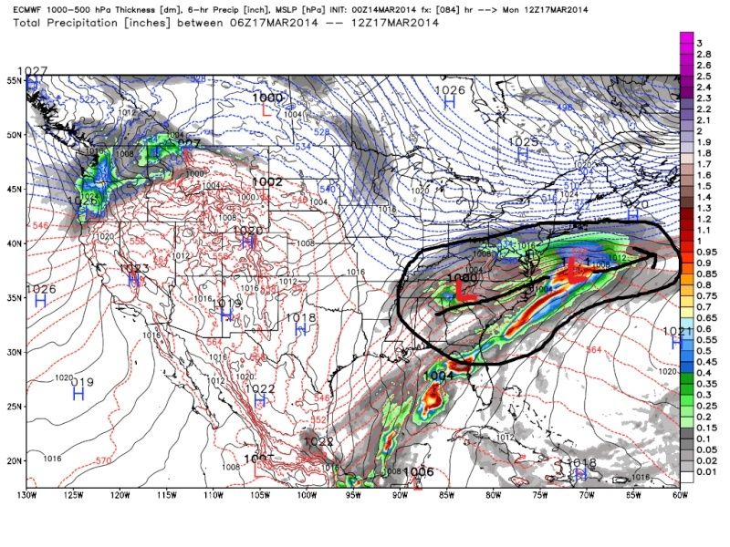
![]() by Frank_Wx Fri Mar 14, 2014 9:44 am
by Frank_Wx Fri Mar 14, 2014 9:44 am
docstox12 wrote:Love that NWS map.Is that Gulf moisture streaming up to feed that heavy rain south--snow north?
If H5 closes off, there will be an impressive amount of moisture with Roidzilla snowfall accumulations possible. Not seeing that right now. I like something in the middle, like a 6-12 inch ordeal
_________________
_______________________________________________________________________________________________________
CLICK HERE to view NJ Strong Snowstorm Classifications
Frank_Wx- Godzilla Seeker
- Posts : 21305
Reputation : 328
Join date : 2013-01-05
Age : 31
Location : Jersey City, NJ -

WOLVES1- Posts : 103
Reputation : 0
Join date : 2013-01-10
Age : 52
Location : Malverne NY
Re: March 17th-18th Storm Potential Discussion
![]() by crippo84 Fri Mar 14, 2014 10:05 am
by crippo84 Fri Mar 14, 2014 10:05 am

crippo84- Posts : 383
Reputation : 20
Join date : 2013-11-07
Age : 40
Location : East Village, NYC
Re: March 17th-18th Storm Potential Discussion
![]() by NjWeatherGuy Fri Mar 14, 2014 10:11 am
by NjWeatherGuy Fri Mar 14, 2014 10:11 am
NjWeatherGuy- Advanced Forecaster
- Posts : 4100
Reputation : 28
Join date : 2013-01-06
Location : Belle Mead, NJ
Re: March 17th-18th Storm Potential Discussion
![]() by deadrabbit79 Fri Mar 14, 2014 10:12 am
by deadrabbit79 Fri Mar 14, 2014 10:12 am
deadrabbit79- Posts : 176
Reputation : 6
Join date : 2013-01-25
Location : Hartsdale, New York
Page 10 of 21 • 1 ... 6 ... 9, 10, 11 ... 15 ... 21 ![]()
|
|
|