
 Search
11/06/14 Rain Event
Page 1 of 2 • 1, 2 ![]()

11/06/14 Rain Event
![]() by Frank_Wx Mon Nov 03, 2014 12:03 pm
by Frank_Wx Mon Nov 03, 2014 12:03 pm
_________________
_______________________________________________________________________________________________________
CLICK HERE to view NJ Strong Snowstorm Classifications

Frank_Wx- Godzilla Seeker

- Posts : 21305
Reputation : 328
Join date : 2013-01-05
Age : 31
Location : Jersey City, NJ -

Re: 11/06/14 Rain Event
![]() by jmanley32 Mon Nov 03, 2014 12:47 pm
by jmanley32 Mon Nov 03, 2014 12:47 pm
MAIN FEATURE OF INTEREST FOR THE WEEK IS NORTHERN STREAM SHORTWAVE
ENERGY DIGGING THROUGH THE GREAT LAKES THU AND TO THE MID ATLANTIC/SE
US COAST BY FRIDAY...WITH POTENTIAL CLOSED LOW DEVELOPMENT OVER THE
NE/NEW ENGLAND. AS MENTIONED ABOVE SOME DIFFERENCES EXIST IN DEGREE
AND RATE OF AMPLIFICATION...WITH SENSITIVITY LYING IN STRENGTH OF
UPPER ENERGY ENTERING WESTERN CANADA TUE MORNING AND DEGREE OF
PHASING WITH DETERIORATING SW TROUGHING AS IT DIGS SE. THIS MANIFESTS
IN DIFFERENCES IN EXACT TIMING AND LOCATION OF CYCLOGENESIS ALONG
THE COAST/COASTAL PLAIN AND TRACK OF THIS SECONDARY LOW. HAVE
CONTINUED WITH MIDDLE OF THE ROAD SOLUTION...WITH DEVELOPMENT OF A
SECONDARY LOW ACROSS MID ATLANTIC THU AND THEN TRACKING NORTH ACROSS
THE REGION THU NIGHT.
WITH GOOD SYNOPTIC SUPPORT AND POTENTIAL FOR ENTRAINING OF MOISTURE
FROM EASTERN PACIFIC TROPICAL CYCLONE VANCE...WILL CONTINUE WITH
LIKELY POPS FOR THU INTO THU NIGHT. A POTENTIAL EXISTS FOR A
PERIOD OF HEAVY RAIN DURING THIS TIME IF MORE AMPLIFIED SOLUTIONS
VERIFY. MODELS IN DECENT AGREEMENT WITH THE INTENSIFYING LOW
PRESSURE SYSTEM DEPARTING N THROUGH SE CANADA ON FRIDAY AS THE
TROUGH AXIS NEGATIVELY PIVOTS THROUGH THE REGION. THIS SHOULD
ALLOW FOR GRADUAL DRYING CONDS WITH CAA ON MODERATE NW WINDS THRU
FRI NIGHT...GRADUALLY RELENTING ON SAT.
ANOTHER SHORTWAVE APPROACHES FOR SUNDAY WITH POTENTIAL FOR ANOTHER
ROUND OF UNSETTLED WEATHER.

jmanley32- Senior Enthusiast

- Posts : 20516
Reputation : 108
Join date : 2013-12-12
Age : 42
Location : Yonkers, NY
Re: 11/06/14 Rain Event
![]() by jmanley32 Mon Nov 03, 2014 8:20 pm
by jmanley32 Mon Nov 03, 2014 8:20 pm
jmanley32- Senior Enthusiast
- Posts : 20516
Reputation : 108
Join date : 2013-12-12
Age : 42
Location : Yonkers, NY
Re: 11/06/14 Rain Event
![]() by Frank_Wx Mon Nov 03, 2014 8:28 pm
by Frank_Wx Mon Nov 03, 2014 8:28 pm
_________________
_______________________________________________________________________________________________________
CLICK HERE to view NJ Strong Snowstorm Classifications
Frank_Wx- Godzilla Seeker
- Posts : 21305
Reputation : 328
Join date : 2013-01-05
Age : 31
Location : Jersey City, NJ -
Re: 11/06/14 Rain Event
![]() by jmanley32 Mon Nov 03, 2014 8:33 pm
by jmanley32 Mon Nov 03, 2014 8:33 pm
jmanley32- Senior Enthusiast
- Posts : 20516
Reputation : 108
Join date : 2013-12-12
Age : 42
Location : Yonkers, NY
Re: 11/06/14 Rain Event
![]() by algae888 Tue Nov 04, 2014 11:16 am
by algae888 Tue Nov 04, 2014 11:16 am

algae888- Advanced Forecaster

- Posts : 5311
Reputation : 46
Join date : 2013-02-05
Age : 61
Location : mt. vernon, new york
Re: 11/06/14 Rain Event
![]() by jmanley32 Tue Nov 04, 2014 11:35 am
by jmanley32 Tue Nov 04, 2014 11:35 am
jmanley32- Senior Enthusiast
- Posts : 20516
Reputation : 108
Join date : 2013-12-12
Age : 42
Location : Yonkers, NY
Re: 11/06/14 Rain Event
![]() by sroc4 Tue Nov 04, 2014 2:04 pm
by sroc4 Tue Nov 04, 2014 2:04 pm
http://www.goes.noaa.gov/dml/comp/goes/nhem/rb.html

As soon as the arctic disturbance, that is currently located over Minnesota on this loop, catches up to the front a LP will develop along the front. It will probably lift up past us somewhere over Eastern Pa, or NW NJ. When it does so a triple point might form, cold front, warm front and occluded front, all meet at one point (center of LP) and enhanced lift occurs. With a tropical moisture feed heavier totals ie: 2-3" could occur in and around the areas where the LP center passes.
http://www.goes.noaa.gov/dml/comp/goes/nhem/wv.html

Right now a general 0.5"-1.5" should occur with higher totals between Queens NY and NW NJ/E Pa.
_________________
"In weather and in life, there's no winning and losing; there's only winning and learning."
WINTER 2012/2013 TOTALS 43.65"WINTER 2017/2018 TOTALS 62.85" WINTER 2022/2023 TOTALS 4.9"
WINTER 2013/2014 TOTALS 64.85"WINTER 2018/2019 TOTALS 14.25" WINTER 2023/2024 TOTALS 13.1"
WINTER 2014/2015 TOTALS 71.20"WINTER 2019/2020 TOTALS 6.35"
WINTER 2015/2016 TOTALS 35.00"WINTER 2020/2021 TOTALS 37.75"
WINTER 2016/2017 TOTALS 42.25"WINTER 2021/2022 TOTALS 31.65"

sroc4- Admin
- Posts : 8331
Reputation : 301
Join date : 2013-01-07
Location : Wading River, LI
Re: 11/06/14 Rain Event
![]() by jmanley32 Tue Nov 04, 2014 3:19 pm
by jmanley32 Tue Nov 04, 2014 3:19 pm
MODELS ARE IN GOOD AGREEMENT WITH THE H5 PATTERN INTO FRI.
DEVIATIONS THEN COME INTO PLAY DUE TO THE PHASING OF THE NORTHERN
AND SOUTHERN STREAM BRANCHES OF THE JET RESULTING IN A DEEP
NEGATIVELY TILTED TROUGH ACROSS THE EASTERN CONUS. THIS LEADS TO
TIMING AND AMPLITUDE DIFFERENCES IN THE UPPER FLOW AND ALSO RESULTS
IN UNCERTAINTY IN THE CONSOLIDATION AND TRACK OF THE SFC LOW.
WHAT SEEMS FAIRLY CERTAIN IS THAT ANOTHER STORM SYSTEM WILL IMPACT
THE AREA THU INTO FRI PRODUCING A FEW INCHES OF RAIN AND WINDY
CONDITIONS...IN ADDITION TO THE POTENTIAL FOR MINOR COASTAL
IMPACT. DUE TO THE SPREAD IN THE TRACK OF THE LOW...THE DETAILS
REMAIN FUZZY AND MAY TAKE A FEW MORE MODEL RUNS TO BE RESOLVED AND
FOR CONFIDENCE TO INCREASE.
AS THE STORM LIFTS THROUGH NEW ENGLAND AND INTO THE CANADIAN
MARITIMES FRI/FRI NIGHT...IT WILL INTENSIFY WITH A TIGHT PRES
GRADIENT REMAINING ACROSS THE AREA WITH HIGH PRES BUILDING OVER THE
SOUTHEAST.
jmanley32- Senior Enthusiast
- Posts : 20516
Reputation : 108
Join date : 2013-12-12
Age : 42
Location : Yonkers, NY
Re: 11/06/14 Rain Event
![]() by sabamfa Tue Nov 04, 2014 3:48 pm
by sabamfa Tue Nov 04, 2014 3:48 pm
sabamfa- Pro Enthusiast

- Posts : 246
Reputation : 2
Join date : 2013-11-05
Age : 37
Location : Wayne, NJ
Re: 11/06/14 Rain Event
![]() by Frank_Wx Tue Nov 04, 2014 5:18 pm
by Frank_Wx Tue Nov 04, 2014 5:18 pm
sabamfa wrote:When might we have a clearer idea about Thursday? My boyfriend & I have Broadway tickets for Thursday night and had taken the day off work to spend the day in the city prior to the show. I'm assuming that's probably not happening not since it is supposed to be so rainy, but I want to know what I'm getting myself into for late afternoon - nighttime (say from 3 or 4 until 11), when we will be in for dinner and the show.
Latest guidance is actually trending weaker and weaker with this storm. The 12z EURO and 18z GFS do not even show a quarter of an inch of rainfall for our area on Thursday. Just a period of light showers. I think your night should be ok. If I had to choose a time period of moderate rain to fall, it will be between 2-6pm. Check back in the morning. Tonights 00z runs will tell the full story
_________________
_______________________________________________________________________________________________________
CLICK HERE to view NJ Strong Snowstorm Classifications
Frank_Wx- Godzilla Seeker
- Posts : 21305
Reputation : 328
Join date : 2013-01-05
Age : 31
Location : Jersey City, NJ -
Re: 11/06/14 Rain Event
![]() by algae888 Tue Nov 04, 2014 5:26 pm
by algae888 Tue Nov 04, 2014 5:26 pm
.LONG TERM /THURSDAY THROUGH MONDAY/...
TWO POTENTIAL STORMS IN THE LONG TERM.
THE FIRST IS THU INTO FRI. THE TREND APPEARS TO BE E WITH THE MODEL
SOLNS. THE GFS ENSEMBLES AND OPERATIONAL GFS AND ECMWF ARE TIGHTLY
CLUSTERED. THIS BRINGS A TRACK OVER OR JUST E OF THE CWA. A TRACK
OVER THE CWA COULD DRY SLOT THE AREA...KEEPING PCPN TOTALS TO A
HALF INCH OR LESS. HOWEVER...ANY JOG TO THE W OR MORE LIKELY TO THE
E BRINGS THE POTENTIAL TO AROUND 1.5 INCHES. FOR THE MOST PART PCPN
ENDS FRI MRNG...HOWEVER THE ECMWF WHICH IS ON THE ERN EDGE OF THE
GUIDANCE DOES PRODUCE SOME MEASURABLE WRAPAROUND PCPN. IF THIS
VERIFIES...THERE COULD BE SOME FLAKES AT LEAST MIXED IN...ESPECIALLY
INTERIOR...AS THE COLD AIR IS DRAWN SWD. THIS IS STILL AN OUTLYING
SOLN...BUT BEARS WATCHING DUE TO THE TREND.
algae888- Advanced Forecaster
- Posts : 5311
Reputation : 46
Join date : 2013-02-05
Age : 61
Location : mt. vernon, new york
Re: 11/06/14 Rain Event
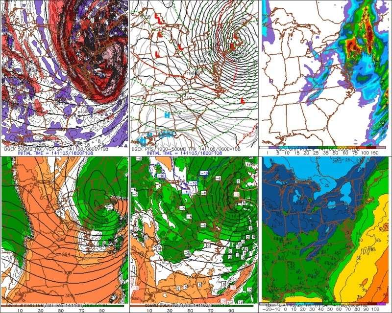
![]() by Frank_Wx Tue Nov 04, 2014 11:21 pm
by Frank_Wx Tue Nov 04, 2014 11:21 pm
00z GFS total qpf

_________________
_______________________________________________________________________________________________________
CLICK HERE to view NJ Strong Snowstorm Classifications
Frank_Wx- Godzilla Seeker
- Posts : 21305
Reputation : 328
Join date : 2013-01-05
Age : 31
Location : Jersey City, NJ -
Re: 11/06/14 Rain Event
![]() by sroc4 Wed Nov 05, 2014 6:53 am
by sroc4 Wed Nov 05, 2014 6:53 am
sroc4 wrote:Unfort I don't have time to post much on this. What I will say is don't be fooled by the American models under estimating potential rainfall. There is a tropical moisture feed associated with the front streaming in from SE PAC. Here is a nice satellite loop showing.
http://www.goes.noaa.gov/dml/comp/goes/nhem/rb.html
As soon as the arctic disturbance, that is currently located over Minnesota on this loop, catches up to the front a LP will develop along the front. It will probably lift up past us somewhere over Eastern Pa, or NW NJ. When it does so a triple point might form, cold front, warm front and occluded front, all meet at one point (center of LP) and enhanced lift occurs. With a tropical moisture feed heavier totals ie: 2-3" could occur in and around the areas where the LP center passes.
http://www.goes.noaa.gov/dml/comp/goes/nhem/wv.html
Right now a general 0.5"-1.5" should occur with higher totals between Queens NY and NW NJ/E Pa.
Well it's hard to go against the models trending drier. I think it's because the front with the moisture feed pushes a tad to far to the east. I still think it's wetter than what last nights Runs are showing however. I'm sticking with my original idea but lowered my high end amts. that most of us will see 0.5-1". But I still believe that there will be an area of higher amts ie:1-2" between Queens and NW NJ in areas of enhanced lifting. That area may have to shift east however to include the rest of LI. IF higher amount occur it will probably be isolated and not include the entire area I stated above. Here is my CYA. I really haven't had the time to spend a lot of time with this system so I may bust horribly.
_________________
"In weather and in life, there's no winning and losing; there's only winning and learning."
WINTER 2012/2013 TOTALS 43.65"WINTER 2017/2018 TOTALS 62.85" WINTER 2022/2023 TOTALS 4.9"
WINTER 2013/2014 TOTALS 64.85"WINTER 2018/2019 TOTALS 14.25" WINTER 2023/2024 TOTALS 13.1"
WINTER 2014/2015 TOTALS 71.20"WINTER 2019/2020 TOTALS 6.35"
WINTER 2015/2016 TOTALS 35.00"WINTER 2020/2021 TOTALS 37.75"
WINTER 2016/2017 TOTALS 42.25"WINTER 2021/2022 TOTALS 31.65"
sroc4- Admin
- Posts : 8331
Reputation : 301
Join date : 2013-01-07
Location : Wading River, LI
Re: 11/06/14 Rain Event
![]() by algae888 Wed Nov 05, 2014 11:14 am
by algae888 Wed Nov 05, 2014 11:14 am
algae888- Advanced Forecaster
- Posts : 5311
Reputation : 46
Join date : 2013-02-05
Age : 61
Location : mt. vernon, new york
Re: 11/06/14 Rain Event
![]() by Frank_Wx Wed Nov 05, 2014 11:22 am
by Frank_Wx Wed Nov 05, 2014 11:22 am
_________________
_______________________________________________________________________________________________________
CLICK HERE to view NJ Strong Snowstorm Classifications
Frank_Wx- Godzilla Seeker
- Posts : 21305
Reputation : 328
Join date : 2013-01-05
Age : 31
Location : Jersey City, NJ -
Re: 11/06/14 Rain Event
![]() by jmanley32 Wed Nov 05, 2014 12:25 pm
by jmanley32 Wed Nov 05, 2014 12:25 pm
jmanley32- Senior Enthusiast
- Posts : 20516
Reputation : 108
Join date : 2013-12-12
Age : 42
Location : Yonkers, NY
Re: 11/06/14 Rain Event
![]() by aiannone Wed Nov 05, 2014 6:44 pm
by aiannone Wed Nov 05, 2014 6:44 pm
_________________
-Alex Iannone-

aiannone- Senior Enthusiast - Mod

- Posts : 4813
Reputation : 92
Join date : 2013-01-07
Location : Saint James, LI (Northwest Suffolk Co.)
Re: 11/06/14 Rain Event
![]() by Frank_Wx Wed Nov 05, 2014 7:48 pm
by Frank_Wx Wed Nov 05, 2014 7:48 pm
Mets2695 wrote:So the alarms have sounded here at Lyndon State. With the shift in the storm track to our east, cold air advection will be able to settle in while there is still precip left. The college is currently forecasting rain tmw evening, mixing and then eventually changing to snow late tomorrow night with accumulations of 2-4in here at the college (1,000ft) and just above us 4-6in above 2,000 ft.
Yea that sounds about right. Take pics!
_________________
_______________________________________________________________________________________________________
CLICK HERE to view NJ Strong Snowstorm Classifications
Frank_Wx- Godzilla Seeker
- Posts : 21305
Reputation : 328
Join date : 2013-01-05
Age : 31
Location : Jersey City, NJ -
Re: 11/06/14 Rain Event
![]() by amugs Wed Nov 05, 2014 8:06 pm
by amugs Wed Nov 05, 2014 8:06 pm
Nice kid enjoy the 1st snowfall!Mets2695 wrote:So the alarms have sounded here at Lyndon State. With the shift in the storm track to our east, cold air advection will be able to settle in while there is still precip left. The college is currently forecasting rain tmw evening, mixing and then eventually changing to snow late tomorrow night with accumulations of 2-4in here at the college (1,000ft) and just above us 4-6in above 2,000 ft.
_________________
Mugs
AKA:King: Snow Weenie
Self Proclaimed
WINTER 2014-15 : 55.12" +.02 for 6 coatings (avg. 35")
WINTER 2015-16 Total - 29.8" (Avg 35")
WINTER 2016-17 : 39.5" so far

amugs- Advanced Forecaster - Mod
- Posts : 15093
Reputation : 213
Join date : 2013-01-07
Age : 54
Location : Hillsdale,NJ
Re: 11/06/14 Rain Event
![]() by aiannone Wed Nov 05, 2014 9:31 pm
by aiannone Wed Nov 05, 2014 9:31 pm
_________________
-Alex Iannone-
aiannone- Senior Enthusiast - Mod
- Posts : 4813
Reputation : 92
Join date : 2013-01-07
Location : Saint James, LI (Northwest Suffolk Co.)
Re: 11/06/14 Rain Event
![]() by Frank_Wx Wed Nov 05, 2014 9:34 pm
by Frank_Wx Wed Nov 05, 2014 9:34 pm
EURO and GFS look solid for at least a 1-3 inch snowfall. I think you'll be fine.
_________________
_______________________________________________________________________________________________________
CLICK HERE to view NJ Strong Snowstorm Classifications
Frank_Wx- Godzilla Seeker
- Posts : 21305
Reputation : 328
Join date : 2013-01-05
Age : 31
Location : Jersey City, NJ -
Re: 11/06/14 Rain Event
![]() by aiannone Wed Nov 05, 2014 9:43 pm
by aiannone Wed Nov 05, 2014 9:43 pm
_________________
-Alex Iannone-
aiannone- Senior Enthusiast - Mod
- Posts : 4813
Reputation : 92
Join date : 2013-01-07
Location : Saint James, LI (Northwest Suffolk Co.)
Re: 11/06/14 Rain Event
![]() by Frank_Wx Wed Nov 05, 2014 10:09 pm
by Frank_Wx Wed Nov 05, 2014 10:09 pm
http://www.accuweather.com/en/us/new-york/nmigs-radar
_________________
_______________________________________________________________________________________________________
CLICK HERE to view NJ Strong Snowstorm Classifications
Frank_Wx- Godzilla Seeker
- Posts : 21305
Reputation : 328
Join date : 2013-01-05
Age : 31
Location : Jersey City, NJ -
Re: 11/06/14 Rain Event
![]() by aiannone Wed Nov 05, 2014 10:50 pm
by aiannone Wed Nov 05, 2014 10:50 pm

_________________
-Alex Iannone-
aiannone- Senior Enthusiast - Mod
- Posts : 4813
Reputation : 92
Join date : 2013-01-07
Location : Saint James, LI (Northwest Suffolk Co.)
Page 1 of 2 • 1, 2 ![]()
|
|
|