
 Search
Thanksgiving Week Forecast
Page 1 of 3 • 1, 2, 3 ![]()

Thanksgiving Week Forecast
![]() by Frank_Wx Wed Nov 19, 2014 11:57 pm
by Frank_Wx Wed Nov 19, 2014 11:57 pm
Monday 11/24: A low pressure system is going to develop near Texas and take a track toward Chicago, raising heights along the east coast on a south-southwesterly flow and opening up the Gulf to tap into some moisture. Another piece of energy along a warm front is what will bring rainfall into our area late Sunday into Monday. Right now, I think this looks more like a 1.00-2.00 inch rainfall, pretty routine from the storms we have seen this Fall, but I can see how it trends weaker or stronger depending on the actual track of the primary low. A start time for the NYC Metro area would be Sunday night, around Midnight, with an end time on Monday possibly as early as 9am. Temperatures on Sunday and Monday will warm up into the 50's and 60's, respectively. I also do not feel winds will be a huge issue. Below is a pic of the 12z EURO from today showing what I just explained above.

If you are traveling on Sunday, my recommendation is to schedule earlier in the day and avoid evening plans. Otherwise, wait until late morning Monday.
Tuesday 11/25: Even though the heaviest of the rain is expected to end Monday morning, there may still be lingering showers and overcast conditions into Tuesday because the primary low tracked into the Lakes and it is expected to move very slowly once it gets there to the north and east. That causes the frontal passage to move very slowly eastward which means temps. even on Tuesday may start out mild but progressively cool down once the front passes to our east. Overall, I think Tuesday will be a GOOD travel day.
Wednesday 11/26: Upper air maps show a lot of H5 energy circulating the eastern U.S. that day and whether or not it turns into a formidable storms remains to be seen. At this time I do not expect that to happen.

This H5 map from the 12z EURO shows the potent s/w, but the general flow is progressive and the Pacific looks pretty flat. In order for something to materialize you need a s/w piece from the northern branch to dig in and phase in with the southern branch. Furthermore, the NAO is expected to be positive so the progressive nature of the pattern continues. Wednesday looks like this on the 12z EURO, colder but at least dry with sunny conditions.

The GFS also has the leftover energy exiting the country and keeping the area cold and dry. I think Wednesday, as of now, looks like another good day of travel but obviously things could change if that leftover energy tries to redevelop itself into a storm. I think it is doubtful, though. Temps. should be in the 40's.
Thanksgiving Day: Right now Turkey Day is looking sunny with temps in the 40's as well. Winds may be coming out of the northwest so be sure to bundle up if you're headed to the parade or other outdoor activities. Travel does not look to be impacted.
There is something though that bares watching, even though I think it could be more of a Black Friday into Saturday type of system. Still, its proximity to Thanksgiving makes me want to still mention it.
The GFS and EURO are not seeing eye to eye on how the Pacific shapes up late next week. The EURO has a wave of low pressure crashing into the Pac. NW around Wednesday next week, while the GFS cuts it off and helps pump up a western ridge.

The latest 00z GFS shows a pretty amplified western ridge coming ashore with H5 pieces ejecting out of the arctic jet and PV that could possibly phase and develop a storm. I do not think it makes sense to try and analyze a storm this far out, especially by the GFS, so that is all I am going to say about it right now. Just keep in mind a coastal storm is possible late next week depending on the timing of certain variables.
Tuesday & Wednesday look like the best travel days. Try and plan for then. Thanksgiving Day I'm going to keep separate from those days for now until the storm threat shows a clearer picture.
_________________
_______________________________________________________________________________________________________
CLICK HERE to view NJ Strong Snowstorm Classifications

Frank_Wx- Godzilla Seeker

- Posts : 21305
Reputation : 328
Join date : 2013-01-05
Age : 31
Location : Jersey City, NJ -

Re: Thanksgiving Week Forecast
![]() by Frank_Wx Thu Nov 20, 2014 12:16 am
by Frank_Wx Thu Nov 20, 2014 12:16 am
_________________
_______________________________________________________________________________________________________
CLICK HERE to view NJ Strong Snowstorm Classifications
Frank_Wx- Godzilla Seeker
- Posts : 21305
Reputation : 328
Join date : 2013-01-05
Age : 31
Location : Jersey City, NJ -
Re: Thanksgiving Week Forecast
![]() by jmanley32 Thu Nov 20, 2014 1:34 am
by jmanley32 Thu Nov 20, 2014 1:34 am

jmanley32- Senior Enthusiast

- Posts : 20516
Reputation : 108
Join date : 2013-12-12
Age : 42
Location : Yonkers, NY
Re: Thanksgiving Week Forecast
![]() by amugs Thu Nov 20, 2014 9:28 am
by amugs Thu Nov 20, 2014 9:28 am
_________________
Mugs
AKA:King: Snow Weenie
Self Proclaimed
WINTER 2014-15 : 55.12" +.02 for 6 coatings (avg. 35")
WINTER 2015-16 Total - 29.8" (Avg 35")
WINTER 2016-17 : 39.5" so far

amugs- Advanced Forecaster - Mod

- Posts : 15093
Reputation : 213
Join date : 2013-01-07
Age : 54
Location : Hillsdale,NJ
Re: Thanksgiving Week Forecast
![]() by Frank_Wx Thu Nov 20, 2014 11:50 pm
by Frank_Wx Thu Nov 20, 2014 11:50 pm
_________________
_______________________________________________________________________________________________________
CLICK HERE to view NJ Strong Snowstorm Classifications
Frank_Wx- Godzilla Seeker
- Posts : 21305
Reputation : 328
Join date : 2013-01-05
Age : 31
Location : Jersey City, NJ -
Re: Thanksgiving Week Forecast
![]() by sroc4 Fri Nov 21, 2014 8:30 am
by sroc4 Fri Nov 21, 2014 8:30 am
sroc4 wrote:NjWeatherGuy wrote:Right now it looks like the pre-Thanksgiving storm will be a cutter. Perhaps warmer than the last storm, for some reason there's been a trend of GLC like storms in late November lately. Pattern doesn't look too exciting in terms of snow chances but it's not too unexpected given it's still November, anything before December is pretty much bonus and I'm glad we saw at least the first snow already even though it didn't stick.
Tom there will def be a cutter pre thanksgiving around the 24th tim frame but there looks to be additional energy coming out of the GOM and a LP tries to develop along the stalled frontal boundary somewhere between 26th-27th time frame. The Canadian shows it best at this point, but again set up looks warm due to progressive flow at H5 off the EC at this point. Very similar to yesterdays set up. In the medium and long range we cant entirely sleep on energy coming out of the GOM and STJ or energy diving in from N Canada. We need the Northern energy to dig more for anything wintery to happen. For now just something to watch. Again it may all end up OTS as well.


Ahh yes Model Mayhem. How sweet it is. The conversation above was from the 18th. So for whatever reason the Tropical tidbits website is not loading therefore these two images from above are not appearing (anyone else having a problem opening that site?). Maybe that will change later when the site is fixed. Anyhow clearly this is still developing into a true potential; however, its far from a done deal as Im sure we all know. It looks like there are some things to try and overcome with the H5 pattern however. Just keep in mind this potential is still in the LR/med-LR and the models have been waffling.
So this potential begins with the Very potent GLC (great lakes cutter) that will affect our area on Monday the 24th. Since the LP center will pass well to our west this system will affect us by the passage of a warm front (edited) which will bring with it rain and gusty winds on Monday and warmer than normal temps preceeding the frontal passage this weekend. This frontal passage moves through and stalls off the east coast setting the stage for later in the week and our Turkey day potential. There will be left over energy associated with the STJ and energy diving in on the polar jet that combined or separate will trigger the possible development of LP along that stalled front to affect our area or not to affect.
 " />
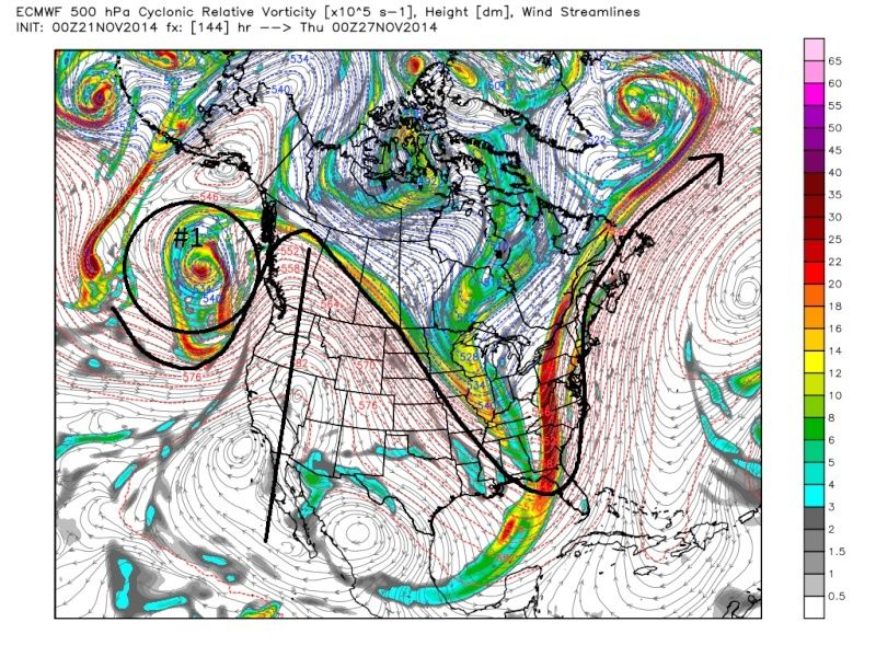
" />Here is the bottom line. We have to see what happens to the ridge out west. Right now the CMC and GFS want to break down the ridge flattening it out as we approach the 26th-27th; whereas the Euro maintains a more amped ridge which in turn slows down the flow allowing more interaction with the STJ and the Polar jet further west bringing a stronger soln closer to the coast and more importantly directing the H5 wind flow more N/NE vs E/NE. If the ridge breaks down to quickly then the circle I have labeled as #1 in the images below acts as a kicker kicking all that energy in the east too far East and OTS with minimal to no impacts for our area.
The images below represent 00z Nov. 27th. First image is the Euro. Notice it is the sharpest with the trough in the east because it has the strongest soln for the ridge in the west. As a result it gives us the strongest soln for an EC threat due to more interactions (phasing) of the two jets (this will not be a full phase). By the looks of the H5 in the NW Atlantic on the models, and looking at the predicted teleconnections for this time frame we don't have anything more than a neutral to Pos NAO which means we wont have much blocking to help us slow things down to our N and E, so that means we have to rely on the pattern to our west to bring this to fruition. And again to reiterate we need that ridge to not break down otherwise the flow becomes too progressive and we lose all that energy OTS.
A couple of things to keep in mind. First the GFS IMHO is not to be trusted AT ALL until it has some sort of agreement by the Euro. It also has a progressive bias esp with Southern energy so I believe it will come back to the west some with its soln and not be so far East with all that energy. Right now I am inclined to go with a blend of both the Euro and CMC solns leaning towards the CMC which would bring some precip into the area, but ultimately the progressive flow wins out and its a quick hitter. That's not to say unexpected amplification couldnt happen like we have already seen with this sort of set up but those details wont be ironed out until we have a clearer picture of H5. In theory with the position of the energy labeled #1 I would think that it would help to pump the ridge like the Euro has; however, I am trying to find a reason why the CMC and GFS are so quick to break down that ridge. The area I have circled but not labeled just east of the area I have circled as #1 is what I think is contributing to this. There are also clearly differences between all three models in how the energy labeled #1 is positioned and how consolidated it is.
Keep this is mind.
1) There appears to be cold air available for precip to POSSIBLY be wintery IF it makes it into our area. I say no more about those details until early next week.
2) The pattern is less than ideal without blocking (Neutral to +NAO); therefore, we have to watch the pattern in the west closely over the next few days for clues.
3) The models are still back and fourth so a lot can change for better or worse.
4) Watch for the possibility of a quick hitting wintery Alberta clipper like system on the heals of this system 28th-30th time frame
 " />
" /> " />
" /> " />
" />Last edited by sroc4 on Fri Nov 21, 2014 12:40 pm; edited 1 time in total
_________________
"In weather and in life, there's no winning and losing; there's only winning and learning."
WINTER 2012/2013 TOTALS 43.65"WINTER 2017/2018 TOTALS 62.85" WINTER 2022/2023 TOTALS 4.9"
WINTER 2013/2014 TOTALS 64.85"WINTER 2018/2019 TOTALS 14.25" WINTER 2023/2024 TOTALS 13.1"
WINTER 2014/2015 TOTALS 71.20"WINTER 2019/2020 TOTALS 6.35"
WINTER 2015/2016 TOTALS 35.00"WINTER 2020/2021 TOTALS 37.75"
WINTER 2016/2017 TOTALS 42.25"WINTER 2021/2022 TOTALS 31.65"

sroc4- Admin
- Posts : 8331
Reputation : 301
Join date : 2013-01-07
Location : Wading River, LI
Re: Thanksgiving Week Forecast
![]() by Snow88 Fri Nov 21, 2014 11:07 am
by Snow88 Fri Nov 21, 2014 11:07 am

Snow88- Senior Enthusiast
- Posts : 2193
Reputation : 4
Join date : 2013-01-09
Age : 35
Location : Brooklyn, NY
Re: Thanksgiving Week Forecast
![]() by Snow88 Fri Nov 21, 2014 11:21 am
by Snow88 Fri Nov 21, 2014 11:21 am
Snow88- Senior Enthusiast
- Posts : 2193
Reputation : 4
Join date : 2013-01-09
Age : 35
Location : Brooklyn, NY
Re: Thanksgiving Week Forecast
![]() by amugs Fri Nov 21, 2014 11:26 am
by amugs Fri Nov 21, 2014 11:26 am

_________________
Mugs
AKA:King: Snow Weenie
Self Proclaimed
WINTER 2014-15 : 55.12" +.02 for 6 coatings (avg. 35")
WINTER 2015-16 Total - 29.8" (Avg 35")
WINTER 2016-17 : 39.5" so far
amugs- Advanced Forecaster - Mod
- Posts : 15093
Reputation : 213
Join date : 2013-01-07
Age : 54
Location : Hillsdale,NJ
Re: Thanksgiving Week Forecast
![]() by Dunnzoo Fri Nov 21, 2014 11:26 am
by Dunnzoo Fri Nov 21, 2014 11:26 am
_________________
Janet
Snowfall winter of 2023-2024 17.5"
Snowfall winter of 2022-2023 6.0"
Snowfall winter of 2021-2022 17.6" 1" sleet 2/25/22
Snowfall winter of 2020-2021 51.1"
Snowfall winter of 2019-2020 8.5"
Snowfall winter of 2018-2019 25.1"
Snowfall winter of 2017-2018 51.9"
Snowfall winter of 2016-2017 45.6"
Snowfall winter of 2015-2016 29.5"
Snowfall winter of 2014-2015 50.55"
Snowfall winter of 2013-2014 66.5"

Dunnzoo- Senior Enthusiast - Mod
- Posts : 4891
Reputation : 68
Join date : 2013-01-11
Age : 62
Location : Westwood, NJ
Re: Thanksgiving Week Forecast
![]() by amugs Fri Nov 21, 2014 11:28 am
by amugs Fri Nov 21, 2014 11:28 am

This would wreck havoc
_________________
Mugs
AKA:King: Snow Weenie
Self Proclaimed
WINTER 2014-15 : 55.12" +.02 for 6 coatings (avg. 35")
WINTER 2015-16 Total - 29.8" (Avg 35")
WINTER 2016-17 : 39.5" so far
amugs- Advanced Forecaster - Mod
- Posts : 15093
Reputation : 213
Join date : 2013-01-07
Age : 54
Location : Hillsdale,NJ
Re: Thanksgiving Week Forecast
![]() by jmanley32 Fri Nov 21, 2014 11:57 am
by jmanley32 Fri Nov 21, 2014 11:57 am
jmanley32- Senior Enthusiast
- Posts : 20516
Reputation : 108
Join date : 2013-12-12
Age : 42
Location : Yonkers, NY
Re: Thanksgiving Week Forecast
![]() by amugs Fri Nov 21, 2014 12:03 pm
by amugs Fri Nov 21, 2014 12:03 pm
Have to keep eye on this one for sure but I do not trust the GooFuS model - CMC has the hot hand and euro from what I understand showing a phase at 6Z? Anyone??
_________________
Mugs
AKA:King: Snow Weenie
Self Proclaimed
WINTER 2014-15 : 55.12" +.02 for 6 coatings (avg. 35")
WINTER 2015-16 Total - 29.8" (Avg 35")
WINTER 2016-17 : 39.5" so far
amugs- Advanced Forecaster - Mod
- Posts : 15093
Reputation : 213
Join date : 2013-01-07
Age : 54
Location : Hillsdale,NJ
Re: Thanksgiving Week Forecast
![]() by jmanley32 Fri Nov 21, 2014 12:06 pm
by jmanley32 Fri Nov 21, 2014 12:06 pm
jmanley32- Senior Enthusiast
- Posts : 20516
Reputation : 108
Join date : 2013-12-12
Age : 42
Location : Yonkers, NY
Re: Thanksgiving Week Forecast
![]() by NjWeatherGuy Fri Nov 21, 2014 12:18 pm
by NjWeatherGuy Fri Nov 21, 2014 12:18 pm
amugs wrote:THEN this..........as Tony pointed out
This would wreck havoc
Whats the deal with the GFS? The one I saw, regular old I believe shows nothing and OTS, is this one more reliable or is the old one more reliable at this juncture? They need to get their act together because im confused

NjWeatherGuy- Advanced Forecaster

- Posts : 4100
Reputation : 28
Join date : 2013-01-06
Location : Belle Mead, NJ
Re: Thanksgiving Week Forecast
![]() by sroc4 Fri Nov 21, 2014 12:32 pm
by sroc4 Fri Nov 21, 2014 12:32 pm
NjWeatherGuy wrote:amugs wrote:THEN this..........as Tony pointed out
This would wreck havoc
Whats the deal with the GFS? The one I saw, regular old I believe shows nothing and OTS, is this one more reliable or is the old one more reliable at this juncture? They need to get their act together because im confused
Exactly Tom. I look at both and ask if the Ensembles or Euro and /or its ensembles agree with one or the other. If no I just cant take either version of the GFS serious
_________________
"In weather and in life, there's no winning and losing; there's only winning and learning."
WINTER 2012/2013 TOTALS 43.65"WINTER 2017/2018 TOTALS 62.85" WINTER 2022/2023 TOTALS 4.9"
WINTER 2013/2014 TOTALS 64.85"WINTER 2018/2019 TOTALS 14.25" WINTER 2023/2024 TOTALS 13.1"
WINTER 2014/2015 TOTALS 71.20"WINTER 2019/2020 TOTALS 6.35"
WINTER 2015/2016 TOTALS 35.00"WINTER 2020/2021 TOTALS 37.75"
WINTER 2016/2017 TOTALS 42.25"WINTER 2021/2022 TOTALS 31.65"
sroc4- Admin
- Posts : 8331
Reputation : 301
Join date : 2013-01-07
Location : Wading River, LI
Re: Thanksgiving Week Forecast
![]() by sroc4 Fri Nov 21, 2014 12:37 pm
by sroc4 Fri Nov 21, 2014 12:37 pm
A WARM FRONT THEN APPROACHES FROM THE SOUTH SUNDAY NIGHT...BRINGING
WIDESPREAD RAIN. MODELS ARE IN EXCELLENT AGREEMENT IN THE TIMING OF
THE BEST LIFT MOVING ACROSS THE REGION BETWEEN 06Z AND 12Z MONDAY.
THE WARM FRONT WILL MOVE NORTH OF THE AREA MONDAY MORNING TAKING THE
BEST LIFT AND DEEPEST MOISTURE NORTH AND EAST. SOME LINGERING LOW
CLOUDS ARE POSSIBLE AFTER THE WARM FRONT PASSES...BUT EXPECT ENOUGH
SUNSHINE IN COMBINATION WITH STRONG SOUTHERLY FLOW TO WARM
TEMPERATURES WELL ABOVE NORMAL. HIGHS WILL REACH THE LOWER AND
MIDDLE 60S...WARMEST IN THE NEW YORK CITY METRO. A COLD FRONT MOVES
THROUGH MONDAY NIGHT WITH A FEW SHOWERS POSSIBLE. BEHIND THE FRONT
ON TUESDAY...TEMPERATURES WILL STILL BE A BIT ABOVE NORMAL IN THE
LOWER AND MIDDLE 50S.
THE FRONT STALLS OFFSHORE TUESDAY INTO WEDNESDAY AS THE PROGRESSION
OF THE UPPER LEVEL TROUGH SLOWS DOWN DUE TO DEEP RIDGING OVER THE
EASTERN ATLANTIC. THIS PATTERN SETS UP A BAROCLINIC ZONE ALONG THE
EAST COAST. 00Z MODELS DEPICT A WAVE OF LOW PRESSURE DEVELOPING
ALONG THIS BAROCLINIC ZONE AS ENERGY ROTATES AROUND THE BASE OF THE
UPPER LEVEL TROUGH. THIS WAVE OF LOW PRESSURE IS FORECAST TO MOVE
EAST OR OVER THE 40/70 BENCHMARK ON WEDNESDAY AND WEDNESDAY NIGHT.
AS EXPECTED SIX DAYS OUT...THERE ARE TIMING AND INTENSITY
DIFFERENCES AMONG THE MODELS. THE 00Z ECMWF IS THE SLOWEST AND
STRONGEST AMONGST THE DETERMINISTIC MODELS. HOWEVER...IT SHOULD BE
NOTED SEVERAL MEMBERS OF THE 00Z GEFS SHOW A SLOWER AND STRONGER LOW
CLOSER TO THE COAST. WILL NEED TO MONITOR FUTURE MODEL TRENDS AS
THIS WILL BE OCCURRING DURING THE BUSIEST TRAVEL DAY OF THE YEAR.
UNCERTAINTIES EXIST IN HOW FAR WEST THE PRECIPITATION SHIELD WILL
REACH...AND THE EXTENT OF COLD AIR IN THE LOW LEVELS THAT WILL BE
AVAILABLE. SYSTEM MOVES NORTH AND EAST ON THURSDAY WITH BELOW NORMAL
TEMPERATURES IN THE 40S.
Last edited by sroc4 on Fri Nov 21, 2014 12:49 pm; edited 1 time in total
_________________
"In weather and in life, there's no winning and losing; there's only winning and learning."
WINTER 2012/2013 TOTALS 43.65"WINTER 2017/2018 TOTALS 62.85" WINTER 2022/2023 TOTALS 4.9"
WINTER 2013/2014 TOTALS 64.85"WINTER 2018/2019 TOTALS 14.25" WINTER 2023/2024 TOTALS 13.1"
WINTER 2014/2015 TOTALS 71.20"WINTER 2019/2020 TOTALS 6.35"
WINTER 2015/2016 TOTALS 35.00"WINTER 2020/2021 TOTALS 37.75"
WINTER 2016/2017 TOTALS 42.25"WINTER 2021/2022 TOTALS 31.65"
sroc4- Admin
- Posts : 8331
Reputation : 301
Join date : 2013-01-07
Location : Wading River, LI
Re: Thanksgiving Week Forecast
![]() by Frank_Wx Fri Nov 21, 2014 12:46 pm
by Frank_Wx Fri Nov 21, 2014 12:46 pm

The old GFS is showing a broader trough, a ridge axis slightly more east, and lackluster northern stream energy that does not dig as much.

The new GFS shows a sharper trough, better ridge axis, and a northern stream piece that digs into the base of the trough. As we've been use to seeing since last winter, we do have the Scandinavian blocking, but with the overall flow still progressive we may need a little more help in the Atlantic. It's a delicate set-up, but one that needs to be watched. Will be interesting to see what EURO says. GGEM does not show a western ridge. That is also critical.
_________________
_______________________________________________________________________________________________________
CLICK HERE to view NJ Strong Snowstorm Classifications
Frank_Wx- Godzilla Seeker
- Posts : 21305
Reputation : 328
Join date : 2013-01-05
Age : 31
Location : Jersey City, NJ -
Re: Thanksgiving Week Forecast
![]() by Frank_Wx Fri Nov 21, 2014 12:51 pm
by Frank_Wx Fri Nov 21, 2014 12:51 pm
_________________
_______________________________________________________________________________________________________
CLICK HERE to view NJ Strong Snowstorm Classifications
Frank_Wx- Godzilla Seeker
- Posts : 21305
Reputation : 328
Join date : 2013-01-05
Age : 31
Location : Jersey City, NJ -
Re: Thanksgiving Week Forecast
![]() by amugs Fri Nov 21, 2014 12:52 pm
by amugs Fri Nov 21, 2014 12:52 pm
I do not know the scoring for the old versus new so I cannot speak on either but they confused the hell out of me too - that is why I posted - maybe in the LR - if anyone had the 6Z euro which another board said there was a phase but more so when the 12z comes out in a bit.
OLD GFS map

Mugs
_________________
Mugs
AKA:King: Snow Weenie
Self Proclaimed
WINTER 2014-15 : 55.12" +.02 for 6 coatings (avg. 35")
WINTER 2015-16 Total - 29.8" (Avg 35")
WINTER 2016-17 : 39.5" so far
amugs- Advanced Forecaster - Mod
- Posts : 15093
Reputation : 213
Join date : 2013-01-07
Age : 54
Location : Hillsdale,NJ
Re: Thanksgiving Week Forecast
![]() by amugs Fri Nov 21, 2014 12:59 pm
by amugs Fri Nov 21, 2014 12:59 pm

_________________
Mugs
AKA:King: Snow Weenie
Self Proclaimed
WINTER 2014-15 : 55.12" +.02 for 6 coatings (avg. 35")
WINTER 2015-16 Total - 29.8" (Avg 35")
WINTER 2016-17 : 39.5" so far
amugs- Advanced Forecaster - Mod
- Posts : 15093
Reputation : 213
Join date : 2013-01-07
Age : 54
Location : Hillsdale,NJ
Re: Thanksgiving Week Forecast
![]() by amugs Fri Nov 21, 2014 1:00 pm
by amugs Fri Nov 21, 2014 1:00 pm
Euro will tell the tale?
_________________
Mugs
AKA:King: Snow Weenie
Self Proclaimed
WINTER 2014-15 : 55.12" +.02 for 6 coatings (avg. 35")
WINTER 2015-16 Total - 29.8" (Avg 35")
WINTER 2016-17 : 39.5" so far
amugs- Advanced Forecaster - Mod
- Posts : 15093
Reputation : 213
Join date : 2013-01-07
Age : 54
Location : Hillsdale,NJ
Re: Thanksgiving Week Forecast
![]() by sroc4 Fri Nov 21, 2014 1:08 pm
by sroc4 Fri Nov 21, 2014 1:08 pm
amugs wrote:Tom,
I do not know the scoring for the old versus new so I cannot speak on either but they confused the hell out of me too - that is why I posted - maybe in the LR - if anyone had the 6Z euro which another board said there was a phase but more so when the 12z comes out in a bit.
OLD GFS map
Mugs
Mugs Euro doesn't have a 6z that I know of. You mean GFS?
_________________
"In weather and in life, there's no winning and losing; there's only winning and learning."
WINTER 2012/2013 TOTALS 43.65"WINTER 2017/2018 TOTALS 62.85" WINTER 2022/2023 TOTALS 4.9"
WINTER 2013/2014 TOTALS 64.85"WINTER 2018/2019 TOTALS 14.25" WINTER 2023/2024 TOTALS 13.1"
WINTER 2014/2015 TOTALS 71.20"WINTER 2019/2020 TOTALS 6.35"
WINTER 2015/2016 TOTALS 35.00"WINTER 2020/2021 TOTALS 37.75"
WINTER 2016/2017 TOTALS 42.25"WINTER 2021/2022 TOTALS 31.65"
sroc4- Admin
- Posts : 8331
Reputation : 301
Join date : 2013-01-07
Location : Wading River, LI
Re: Thanksgiving Week Forecast
![]() by amugs Fri Nov 21, 2014 1:13 pm
by amugs Fri Nov 21, 2014 1:13 pm
_________________
Mugs
AKA:King: Snow Weenie
Self Proclaimed
WINTER 2014-15 : 55.12" +.02 for 6 coatings (avg. 35")
WINTER 2015-16 Total - 29.8" (Avg 35")
WINTER 2016-17 : 39.5" so far
amugs- Advanced Forecaster - Mod
- Posts : 15093
Reputation : 213
Join date : 2013-01-07
Age : 54
Location : Hillsdale,NJ
Re: Thanksgiving Week Forecast
![]() by sroc4 Fri Nov 21, 2014 1:23 pm
by sroc4 Fri Nov 21, 2014 1:23 pm

_________________
"In weather and in life, there's no winning and losing; there's only winning and learning."
WINTER 2012/2013 TOTALS 43.65"WINTER 2017/2018 TOTALS 62.85" WINTER 2022/2023 TOTALS 4.9"
WINTER 2013/2014 TOTALS 64.85"WINTER 2018/2019 TOTALS 14.25" WINTER 2023/2024 TOTALS 13.1"
WINTER 2014/2015 TOTALS 71.20"WINTER 2019/2020 TOTALS 6.35"
WINTER 2015/2016 TOTALS 35.00"WINTER 2020/2021 TOTALS 37.75"
WINTER 2016/2017 TOTALS 42.25"WINTER 2021/2022 TOTALS 31.65"
sroc4- Admin
- Posts : 8331
Reputation : 301
Join date : 2013-01-07
Location : Wading River, LI
Page 1 of 3 • 1, 2, 3 ![]()
|
|
|