
 Search
Official Long Range Thread 5.0
Page 39 of 40 •  1 ... 21 ... 38, 39, 40
 ![]()
Re: Official Long Range Thread 5.0
![]() by Frank_Wx Wed Jan 14, 2015 8:53 pm
by Frank_Wx Wed Jan 14, 2015 8:53 pm
12z EURO

The EURO does a great job in digging the northern (#1) and southern (#2) stream energies resulting in a phase over the Mid-Atlantic. The trough goes from neutrally tilted to negative enabling cold air to get pulled down to the coast. Granted, the coast starts warm this run because H5 closes off over eastern PA, but cold air is quickly crashing east and some areas change from a heavy rain to snow. Where H5 closes off will determine the temperatures for this possible storm.
You notice the western ridge (#3) is not exactly oriented favorably. A potent piece of s/w energy is crashing into the Pac. NW which will collapse the ridge and turn the upper air flow to a zonal state. On the next image you'll see what I mean.

Taking a look at the EURO height anomaly map you notice the ridge collapses but there is a pretty nice storm along the coast because of how the phase came together downstream. Timing is going to play a large role in how this storm shapes out because the overall flow remains progressive. The blocking is not yet established and the PV is re-developing over Arctic. The large trough (#1) about to settle over the Aleutians is going to set the tone for a pattern change around the 22nd or so, which may also feature another storm threat. At that time, I feel like the blocking will be better established and there will be more cold air to work with, too.
12z GFS

The GFS actually takes the northern stream (#1) east into Canada while the more potent piece of energy (#2) digs into the eastern CONUS. I also marked the energy coming ashore in the Pac. NW and you'll notice the GFS is really amp'd with it. Thus, the western ridge collapses much quicker compared to the EURO so the flow turns zonal in a not-so ideal time.

H5 closes off well to our north and west over Upstate NY but the storm is located off our coast due to the quicker breakdown of the western ridge, turning the upper air flow zonal. While the EURO deepens the storm near 985mb, the GFS struggles to get sub 1000mb due to the sloppy look at H5.
Conclusion
Personally, this is not a set-up screaming "big" storm to me but there remains the possibility that a weak storm impacts our area bringing rain or snow. I do not feel the overall pattern supports a potent storm the EURO is showing. A collapsing ridge out west, a poorly established block transient in nature, and a split PV is not a recipe for a big storm. Again, precip type will come down to the timing of the phase and where it takes place. It would not shock me if the storm does not materialize and the energy escapes out to sea. But we'll see.
That said, I touched on in the EURO section of this write-up that I like where the pattern is headed post Jan. 21st or so. This has been the time frame I and many others have liked for awhile now once we realized the effects the Stratosphere will bring to our Troposphere, as well as, seeing the tropical forcing propagate eastward toward and east of the Dateline. In my mind, the period to watch remains the 22nd-26th with even more chances after that.
Frank_Wx- Godzilla Seeker

- Posts : 21305
Join date : 2013-01-05 -

Re: Official Long Range Thread 5.0
![]() by rb924119 Wed Jan 14, 2015 11:27 pm
by rb924119 Wed Jan 14, 2015 11:27 pm
rb924119- Meteorologist

- Posts : 6890
Join date : 2013-02-06


jmanley32- Senior Enthusiast

- Posts : 20516
Reputation : 108
Join date : 2013-12-12
Age : 42
Location : Yonkers, NY
Re: Official Long Range Thread 5.0
![]() by jmanley32 Wed Jan 14, 2015 11:56 pm
by jmanley32 Wed Jan 14, 2015 11:56 pm
jmanley32- Senior Enthusiast
- Posts : 20516
Reputation : 108
Join date : 2013-12-12
Age : 42
Location : Yonkers, NY
Re: Official Long Range Thread 5.0
![]() by jmanley32 Thu Jan 15, 2015 12:02 am
by jmanley32 Thu Jan 15, 2015 12:02 am
This is a huge change from the 18z, which was squashed to the south. This period is peeking my interest, also in the hopes that the new GFS is top notch. If Euro agrees we def have a 8-10 day nail biter.
jmanley32- Senior Enthusiast
- Posts : 20516
Reputation : 108
Join date : 2013-12-12
Age : 42
Location : Yonkers, NY
Re: Official Long Range Thread 5.0
![]() by Math23x7 Thu Jan 15, 2015 1:57 am
by Math23x7 Thu Jan 15, 2015 1:57 am
This is what CP said around mid-December:
CPcantmeasuresnow wrote:I've noticed through the years that long range east coast storms come and go on the models but these damn GLC's like the one shown for Christmas Eve will be there for the next 8 days and will happen just like predicted. Why can't it happen that way in reverse.
Well CP, given how this winter has been, it wouldn't surprise me in the slightest if the potential storm for next week endures the same fate. Think of the Great Lakes as a black hole. Once a low is shown going through them it cannot escape.
Math23x7- Wx Statistician Guru

- Posts : 2379
Reputation : 68
Join date : 2013-01-08
Re: Official Long Range Thread 5.0
![]() by algae888 Thu Jan 15, 2015 2:29 am
by algae888 Thu Jan 15, 2015 2:29 am


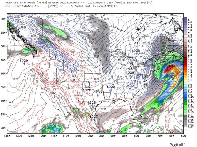
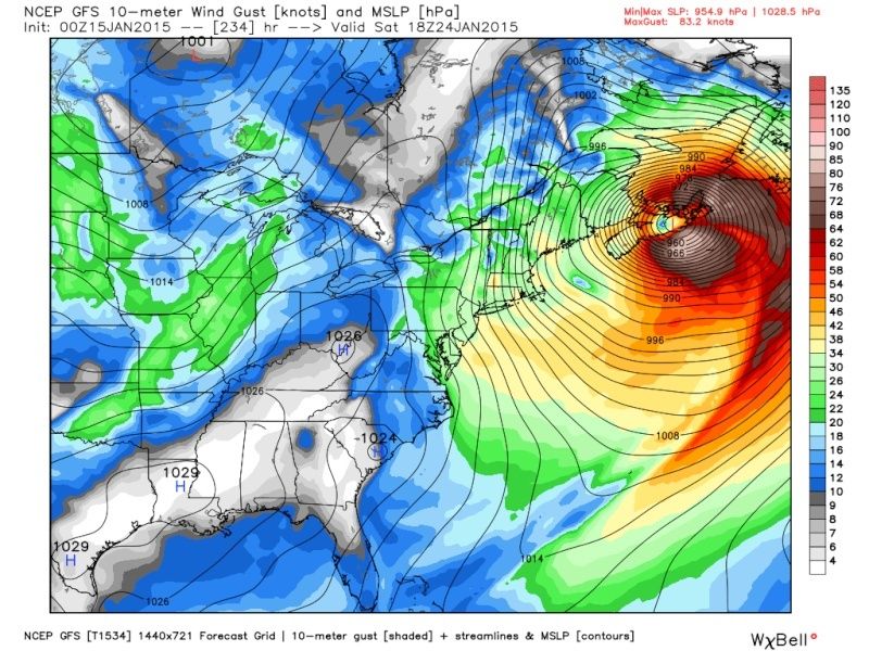
so tonight runs for 1/23 euro=glc cmc=BM gfs=south of BM. the good news all three have an intense storm now for several runs. fun times ahead.

algae888- Advanced Forecaster

- Posts : 5311
Reputation : 46
Join date : 2013-02-05
Age : 61
Location : mt. vernon, new york

algae888- Advanced Forecaster
- Posts : 5311
Reputation : 46
Join date : 2013-02-05
Age : 61
Location : mt. vernon, new york
Re: Official Long Range Thread 5.0
![]() by algae888 Thu Jan 15, 2015 2:43 am
by algae888 Thu Jan 15, 2015 2:43 am

we do not want a strong storm this weekend imo as the next clipper that comes in for wens. will probably be sheared apart if op gfs and euro verify. the weaker the system sunday the better chance the wens clipper has at bringing us a light snowfall.
algae888- Advanced Forecaster
- Posts : 5311
Reputation : 46
Join date : 2013-02-05
Age : 61
Location : mt. vernon, new york
Re: Official Long Range Thread 5.0
![]() by algae888 Thu Jan 15, 2015 2:46 am
by algae888 Thu Jan 15, 2015 2:46 am
algae888- Advanced Forecaster
- Posts : 5311
Reputation : 46
Join date : 2013-02-05
Age : 61
Location : mt. vernon, new york
Re: Official Long Range Thread 5.0
![]() by jmanley32 Thu Jan 15, 2015 6:50 am
by jmanley32 Thu Jan 15, 2015 6:50 am
jmanley32- Senior Enthusiast
- Posts : 20516
Reputation : 108
Join date : 2013-12-12
Age : 42
Location : Yonkers, NY
Re: Official Long Range Thread 5.0
![]() by jmanley32 Thu Jan 15, 2015 7:09 am
by jmanley32 Thu Jan 15, 2015 7:09 am
jmanley32- Senior Enthusiast
- Posts : 20516
Reputation : 108
Join date : 2013-12-12
Age : 42
Location : Yonkers, NY
Re: Official Long Range Thread 5.0
![]() by Frank_Wx Thu Jan 15, 2015 7:25 am
by Frank_Wx Thu Jan 15, 2015 7:25 am
The Sunday storm still needs to be watched but I stand by my initial analysis of either a weak storm bringing rain and snow, or one that goes out to sea (6z GFS showed this). Euro is way too amplified with it.
Have a good day. Maybe I'll update again around 2pm
_________________
_______________________________________________________________________________________________________
CLICK HERE to view NJ Strong Snowstorm Classifications

Frank_Wx- Godzilla Seeker
- Posts : 21305
Reputation : 328
Join date : 2013-01-05
Age : 31
Location : Jersey City, NJ -
Re: Official Long Range Thread 5.0
![]() by sroc4 Thu Jan 15, 2015 7:58 am
by sroc4 Thu Jan 15, 2015 7:58 am
_________________
"In weather and in life, there's no winning and losing; there's only winning and learning."
WINTER 2012/2013 TOTALS 43.65"WINTER 2017/2018 TOTALS 62.85" WINTER 2022/2023 TOTALS 4.9"
WINTER 2013/2014 TOTALS 64.85"WINTER 2018/2019 TOTALS 14.25" WINTER 2023/2024 TOTALS 13.1"
WINTER 2014/2015 TOTALS 71.20"WINTER 2019/2020 TOTALS 6.35"
WINTER 2015/2016 TOTALS 35.00"WINTER 2020/2021 TOTALS 37.75"
WINTER 2016/2017 TOTALS 42.25"WINTER 2021/2022 TOTALS 31.65"

sroc4- Admin
- Posts : 8331
Reputation : 301
Join date : 2013-01-07
Location : Wading River, LI
Re: Official Long Range Thread 5.0
![]() by sroc4 Thu Jan 15, 2015 8:02 am
by sroc4 Thu Jan 15, 2015 8:02 am
SUCCESSIVE CYCLES OF GUIDANCE ARE GRADUALLY INCREASING CONFIDENCE
IN THE EXISTENCE OF A SIGNIFICANT STORM THAT SHOULD DEEPEN AS IT
TRACKS NWD NEAR THE EAST COAST SUN-MON. HOWEVER CRUCIAL DETAILS
IN TRACK/STRENGTH WILL TAKE ADDED TIME TO WORK OUT SINCE THE
SOURCE ENERGY ALOFT IS STILL OVER THE ERN PAC AND NOT SCHEDULED TO
REACH THE WEST COAST UNTIL AROUND EARLY FRI. STEADILY DEEPER
TREND OF THE SFC LOW IN ECMWF MEANS OVER THE PAST 24-36 HRS SEEMS
TO SUPPORT PARTIAL WEIGHT OF OPERATIONAL SOLNS THAT ARE STRONGER
THAN THE MEANS. WITH A FAIR CLUSTER OF MODEL SOLNS AND EVENTUALLY
THE ECMWF MEAN CLOSING OFF AN UPR LOW OVER THE NORTHEAST... AS
WELL AS A WWD TREND IN THE 00Z GFS TOWARD THE 12Z ECMWF.
_________________
"In weather and in life, there's no winning and losing; there's only winning and learning."
WINTER 2012/2013 TOTALS 43.65"WINTER 2017/2018 TOTALS 62.85" WINTER 2022/2023 TOTALS 4.9"
WINTER 2013/2014 TOTALS 64.85"WINTER 2018/2019 TOTALS 14.25" WINTER 2023/2024 TOTALS 13.1"
WINTER 2014/2015 TOTALS 71.20"WINTER 2019/2020 TOTALS 6.35"
WINTER 2015/2016 TOTALS 35.00"WINTER 2020/2021 TOTALS 37.75"
WINTER 2016/2017 TOTALS 42.25"WINTER 2021/2022 TOTALS 31.65"
sroc4- Admin
- Posts : 8331
Reputation : 301
Join date : 2013-01-07
Location : Wading River, LI
Re: Official Long Range Thread 5.0
![]() by docstox12 Thu Jan 15, 2015 8:32 am
by docstox12 Thu Jan 15, 2015 8:32 am
Frank_Wx wrote:Models are beginning to take note of the pattern change that will occur after the 21st. You're beginning to see a lot more fantasy storms show up, positive heights in the EPO and NAO regions, and consistent below normal cold. This pattern change will be our best one yet this winter. I would be very surprised if it does not deliver at least a 6 inch snowfall to the area.
The Sunday storm still needs to be watched but I stand by my initial analysis of either a weak storm bringing rain and snow, or one that goes out to sea (6z GFS showed this). Euro is way too amplified with it.
Have a good day. Maybe I'll update again around 2pm
Good news and a decidedly more positive note in a frustrating winter for snow lovers.
Lot's of time available for this to play out.

docstox12- Wx Statistician Guru
- Posts : 8504
Reputation : 222
Join date : 2013-01-07
Age : 73
Location : Monroe NY
Re: Official Long Range Thread 5.0
![]() by CPcantmeasuresnow Thu Jan 15, 2015 9:48 am
by CPcantmeasuresnow Thu Jan 15, 2015 9:48 am
Next Friday the 23rd TWC has my area with a wintry mix changing to all snow with a high of 32.
Accuweather for the same day has a high of 37 with a wintry mix changing to rain. 1.89 inches of rain that day.
Two completely different schools of thought and I'm sure they will flip flop several times before then. I'm sure a lot of the confusion has to do with the pattern change Frank, Sroc and several others have been talking about which MAY happen next week.
At least it's something to watch.

CPcantmeasuresnow- Wx Statistician Guru
- Posts : 7274
Reputation : 230
Join date : 2013-01-07
Age : 103
Location : Eastern Orange County, NY
Re: Official Long Range Thread 5.0
![]() by Frank_Wx Thu Jan 15, 2015 10:14 am
by Frank_Wx Thu Jan 15, 2015 10:14 am
CPcantmeasuresnow wrote:It's 8 days away so we all know how that usually plays out but:
Next Friday the 23rd TWC has my area with a wintry mix changing to all snow with a high of 32.
Accuweather for the same day has a high of 37 with a wintry mix changing to rain. 1.89 inches of rain that day.
Two completely different schools of thought and I'm sure they will flip flop several times before then. I'm sure a lot of the confusion has to do with the pattern change Frank, Sroc and several others have been talking about which MAY happen next week.
At least it's something to watch.
The storm Doc posted the discussion to and the one I made an analysis on (look 1 or 2 pages back) is in reference to the 18th - 3 days away
_________________
_______________________________________________________________________________________________________
CLICK HERE to view NJ Strong Snowstorm Classifications
Frank_Wx- Godzilla Seeker
- Posts : 21305
Reputation : 328
Join date : 2013-01-05
Age : 31
Location : Jersey City, NJ -
Re: Official Long Range Thread 5.0
![]() by Frank_Wx Thu Jan 15, 2015 10:16 am
by Frank_Wx Thu Jan 15, 2015 10:16 am
_________________
_______________________________________________________________________________________________________
CLICK HERE to view NJ Strong Snowstorm Classifications
Frank_Wx- Godzilla Seeker
- Posts : 21305
Reputation : 328
Join date : 2013-01-05
Age : 31
Location : Jersey City, NJ -
Re: Official Long Range Thread 5.0
![]() by CPcantmeasuresnow Thu Jan 15, 2015 10:32 am
by CPcantmeasuresnow Thu Jan 15, 2015 10:32 am
Frank_Wx wrote:CPcantmeasuresnow wrote:It's 8 days away so we all know how that usually plays out but:
Next Friday the 23rd TWC has my area with a wintry mix changing to all snow with a high of 32.
Accuweather for the same day has a high of 37 with a wintry mix changing to rain. 1.89 inches of rain that day.
Two completely different schools of thought and I'm sure they will flip flop several times before then. I'm sure a lot of the confusion has to do with the pattern change Frank, Sroc and several others have been talking about which MAY happen next week.
At least it's something to watch.
The storm Doc posted the discussion to and the one I made an analysis on (look 1 or 2 pages back) is in reference to the 18th - 3 days away
Understood but we're talking about two different storms.
I'm referencing the confusion for the 23rd storm that TWC and accuweather have completely differing views on right now. I attribute the confusion the models may be having with that storm to the pattern change you reference may happen after the 21st.
CPcantmeasuresnow- Wx Statistician Guru
- Posts : 7274
Reputation : 230
Join date : 2013-01-07
Age : 103
Location : Eastern Orange County, NY
Re: Official Long Range Thread 5.0
![]() by Frank_Wx Thu Jan 15, 2015 10:36 am
by Frank_Wx Thu Jan 15, 2015 10:36 am
We will not know how the evolution of the 21st storm plays out until we get the 18th storm out of the way. The storm on the 18th could act as a 50-50 low in southeast Canada. If it does, that will have drastic differences with how the 21st storm plays out.
_________________
_______________________________________________________________________________________________________
CLICK HERE to view NJ Strong Snowstorm Classifications
Frank_Wx- Godzilla Seeker
- Posts : 21305
Reputation : 328
Join date : 2013-01-05
Age : 31
Location : Jersey City, NJ -
Re: Official Long Range Thread 5.0
![]() by skinsfan1177 Thu Jan 15, 2015 11:06 am
by skinsfan1177 Thu Jan 15, 2015 11:06 am

skinsfan1177- Senior Enthusiast
- Posts : 4485
Reputation : 35
Join date : 2013-01-07
Age : 46
Location : Point Pleasant Boro
Re: Official Long Range Thread 5.0
![]() by sroc4 Thu Jan 15, 2015 11:22 am
by sroc4 Thu Jan 15, 2015 11:22 am
skinsfan1177 wrote:So does the storm on the 18th have potential to change to snow
IMO the potential exists, but is unlikely for most of us in this board. NW NJ or more likely the HV
_________________
"In weather and in life, there's no winning and losing; there's only winning and learning."
WINTER 2012/2013 TOTALS 43.65"WINTER 2017/2018 TOTALS 62.85" WINTER 2022/2023 TOTALS 4.9"
WINTER 2013/2014 TOTALS 64.85"WINTER 2018/2019 TOTALS 14.25" WINTER 2023/2024 TOTALS 13.1"
WINTER 2014/2015 TOTALS 71.20"WINTER 2019/2020 TOTALS 6.35"
WINTER 2015/2016 TOTALS 35.00"WINTER 2020/2021 TOTALS 37.75"
WINTER 2016/2017 TOTALS 42.25"WINTER 2021/2022 TOTALS 31.65"
sroc4- Admin
- Posts : 8331
Reputation : 301
Join date : 2013-01-07
Location : Wading River, LI
Re: Official Long Range Thread 5.0
![]() by CPcantmeasuresnow Thu Jan 15, 2015 11:24 am
by CPcantmeasuresnow Thu Jan 15, 2015 11:24 am
CPcantmeasuresnow- Wx Statistician Guru
- Posts : 7274
Reputation : 230
Join date : 2013-01-07
Age : 103
Location : Eastern Orange County, NY
Re: Official Long Range Thread 5.0
![]() by Frank_Wx Thu Jan 15, 2015 11:29 am
by Frank_Wx Thu Jan 15, 2015 11:29 am
_________________
_______________________________________________________________________________________________________
CLICK HERE to view NJ Strong Snowstorm Classifications
Frank_Wx- Godzilla Seeker
- Posts : 21305
Reputation : 328
Join date : 2013-01-05
Age : 31
Location : Jersey City, NJ -
Re: Official Long Range Thread 5.0
![]() by skinsfan1177 Thu Jan 15, 2015 11:32 am
by skinsfan1177 Thu Jan 15, 2015 11:32 am
skinsfan1177- Senior Enthusiast
- Posts : 4485
Reputation : 35
Join date : 2013-01-07
Age : 46
Location : Point Pleasant Boro
Re: Official Long Range Thread 5.0
![]() by Frank_Wx Thu Jan 15, 2015 11:36 am
by Frank_Wx Thu Jan 15, 2015 11:36 am
skinsfan1177 wrote:Ok so GFS probably has it right being the pattern supports it .
In my opinion, yes. Last night I portrayed what the upper air pattern shows and that's a collapsing ridge and a poorly established block. But the storm around the 22nd will be one to watch. Should be in a better pattern then. I'll do analysis on that storm over the weekend.
_________________
_______________________________________________________________________________________________________
CLICK HERE to view NJ Strong Snowstorm Classifications
Frank_Wx- Godzilla Seeker
- Posts : 21305
Reputation : 328
Join date : 2013-01-05
Age : 31
Location : Jersey City, NJ -
Page 39 of 40 • 1 ... 21 ... 38, 39, 40 ![]()
|
|
|