
 Search
ENSEMBLE FORECAST #3 JAN 25th
3 posters

ENSEMBLE FORECAST #3 JAN 25th
![]() by sroc4 Sat Jan 17, 2015 7:54 am
by sroc4 Sat Jan 17, 2015 7:54 am
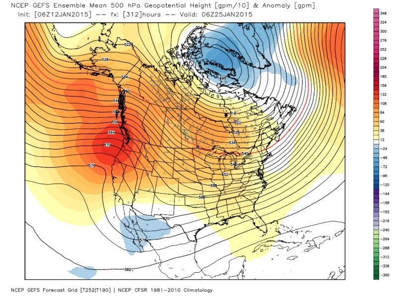
The first image was taken from the Jan12th Run; The second from today Jan 17th:
Euro

 " />
" />
 " />
" />
GFS
 " />
" />
 " />
" />
CMC
 " />
" />
 " />
" />
Well clearly you can see the evolution is that of the mean trough into the east and ridging in the west. That should sound familiar, unfort it also looks like we are back to lower height anomalies into Greenland. (pos to neutral NAO look). With the current look you see above we can def still get a strong storm to develop however it looks as if we need to rely on the pattern in the west to do the work rather than the NAO in the east. The look you see from todays images is still evolving however. The good news is the very strong look to the ridge in the west which is our +PNA, -EPO couplet is there. Without the NAO in our favor we NEED that to have a chance. Unfort with this pattern the ingredients have to come together with more precision timing otherwise one of two things happen. 1) you lose alot of the energy off the coast because of the progressive nature of the neutral to +NAO setup and we end up with the dreaded S and E storm track with phasing too late and cold and dry conditions. Or 2) the strong western ridge drives the northern energy in too fast and phases the N and S streams early and we get a stronger system that trys to cut with a west track. That means bitter cold followed by brief warm up out ahead of our storm, rain/slop, then back to bitter cold on the back side like we are looking at for Sunday.
When examining the 500mb vorticity maps in the medium and LR it is clear that there is still lots of potential in the atmosphere swirling around esp the further out in time we go. Because there is so much energy, or so many ingredients in the pot in the LR, the solns we see put out run to run, model to model beyond 3-5days will change time and time again. Just take a look at the Euro Ens images form last night as of Jan26th. Can we get any more spread on where a LOW might be?? Sheesh.
 " />
" />
So I like the rest of you snow lovers sit here patient yet frustrated watching for what I feel is a chance at accumulating snow. Right now I will buy nothing until its under 5days at the least no matter how tantalizing it may seem because the pattern is just not there yet. (will it get there?? Don't know) That being said I am pretty confident that most of us should see something to measure regarding the clipper for Late Tues/Wed. Wont feel confident in how much until Sunday/Monday 0z the earliest.
Euro
" />" />GFS
" />" />CMC
" />" />Well clearly you can see the evolution is that of the mean trough into the east and ridging in the west. That should sound familiar, unfort it also looks like we are back to lower height anomalies into Greenland. (pos to neutral NAO look). With the current look you see above we can def still get a strong storm to develop however it looks as if we need to rely on the pattern in the west to do the work rather than the NAO in the east. The look you see from todays images is still evolving however. The good news is the very strong look to the ridge in the west which is our +PNA, -EPO couplet is there. Without the NAO in our favor we NEED that to have a chance. Unfort with this pattern the ingredients have to come together with more precision timing otherwise one of two things happen. 1) you lose alot of the energy off the coast because of the progressive nature of the neutral to +NAO setup and we end up with the dreaded S and E storm track with phasing too late and cold and dry conditions. Or 2) the strong western ridge drives the northern energy in too fast and phases the N and S streams early and we get a stronger system that trys to cut with a west track. That means bitter cold followed by brief warm up out ahead of our storm, rain/slop, then back to bitter cold on the back side like we are looking at for Sunday.
When examining the 500mb vorticity maps in the medium and LR it is clear that there is still lots of potential in the atmosphere swirling around esp the further out in time we go. Because there is so much energy, or so many ingredients in the pot in the LR, the solns we see put out run to run, model to model beyond 3-5days will change time and time again. Just take a look at the Euro Ens images form last night as of Jan26th. Can we get any more spread on where a LOW might be?? Sheesh.
" />So I like the rest of you snow lovers sit here patient yet frustrated watching for what I feel is a chance at accumulating snow. Right now I will buy nothing until its under 5days at the least no matter how tantalizing it may seem because the pattern is just not there yet. (will it get there?? Don't know) That being said I am pretty confident that most of us should see something to measure regarding the clipper for Late Tues/Wed. Wont feel confident in how much until Sunday/Monday 0z the earliest.
_________________
"In weather and in life, there's no winning and losing; there's only winning and learning."
WINTER 2012/2013 TOTALS 43.65"WINTER 2017/2018 TOTALS 62.85" WINTER 2022/2023 TOTALS 4.9"
WINTER 2013/2014 TOTALS 64.85"WINTER 2018/2019 TOTALS 14.25" WINTER 2023/2024 TOTALS 13.1"
WINTER 2014/2015 TOTALS 71.20"WINTER 2019/2020 TOTALS 6.35"
WINTER 2015/2016 TOTALS 35.00"WINTER 2020/2021 TOTALS 37.75"
WINTER 2016/2017 TOTALS 42.25"WINTER 2021/2022 TOTALS 31.65"

sroc4- Admin

- Posts : 8331
Reputation : 301
Join date : 2013-01-07
Location : Wading River, LI
Re: ENSEMBLE FORECAST #3 JAN 25th
![]() by skinsfan1177 Sat Jan 17, 2015 8:26 am
by skinsfan1177 Sat Jan 17, 2015 8:26 am
Great write up sroc but I feel we need to get a -nao with the rest of the signals in line. I remember hearing multiple times that's a key factor for US.

skinsfan1177- Senior Enthusiast

- Posts : 4485
Reputation : 35
Join date : 2013-01-07
Age : 46
Location : Point Pleasant Boro
Re: ENSEMBLE FORECAST #3 JAN 25th
![]() by Guest Sat Jan 17, 2015 8:29 am
by Guest Sat Jan 17, 2015 8:29 am
Great write up sroc4. You made it easy to understand and gave good visuals to back up your analysis. The pattern sucks and has the entire winter PERIOD. I love snow and hate rain in the winter, but I hate it even more when it's cold enough for snow 95% of the time and the storms only hit when it's warm enough for rain. That's what we're in.
Guest- Guest
Re: ENSEMBLE FORECAST #3 JAN 25th
![]() by sroc4 Sat Jan 17, 2015 8:34 am
by sroc4 Sat Jan 17, 2015 8:34 am
Agreed on both points skins and Syo. But skins there are plenty of years and storms without a neg NAO last year is one of them. It def makes things easier.
_________________
"In weather and in life, there's no winning and losing; there's only winning and learning."
WINTER 2012/2013 TOTALS 43.65"WINTER 2017/2018 TOTALS 62.85" WINTER 2022/2023 TOTALS 4.9"
WINTER 2013/2014 TOTALS 64.85"WINTER 2018/2019 TOTALS 14.25" WINTER 2023/2024 TOTALS 13.1"
WINTER 2014/2015 TOTALS 71.20"WINTER 2019/2020 TOTALS 6.35"
WINTER 2015/2016 TOTALS 35.00"WINTER 2020/2021 TOTALS 37.75"
WINTER 2016/2017 TOTALS 42.25"WINTER 2021/2022 TOTALS 31.65"
sroc4- Admin
- Posts : 8331
Reputation : 301
Join date : 2013-01-07
Location : Wading River, LI
Re: ENSEMBLE FORECAST #3 JAN 25th
![]() by skinsfan1177 Sat Jan 17, 2015 8:45 am
by skinsfan1177 Sat Jan 17, 2015 8:45 am
Right sroc good point but wasn't that because we had deepening troughs that went negative tilted and this year seems to be a flat progressive flow. Also last year the PV was positioned in a good spot this year it seems to retreat when big storms come our way.
skinsfan1177- Senior Enthusiast
- Posts : 4485
Reputation : 35
Join date : 2013-01-07
Age : 46
Location : Point Pleasant Boro
Re: ENSEMBLE FORECAST #3 JAN 25th
![]() by Frank_Wx Sat Jan 17, 2015 9:00 am
by Frank_Wx Sat Jan 17, 2015 9:00 am
Those maps actually verified pretty well from Jan. 12th. Nice writeup
_________________
_______________________________________________________________________________________________________
CLICK HERE to view NJ Strong Snowstorm Classifications

Frank_Wx- Godzilla Seeker
- Posts : 21305
Reputation : 328
Join date : 2013-01-05
Age : 31
Location : Jersey City, NJ -

Permissions in this forum:
You cannot reply to topics in this forum|
|
|