
 Search
SNOW MAPS ONLY: MON JAN 26TH - JAN 27TH
+7
amugs
jmanley32
skinsfan1177
Quietace
carvin1079
docstox12
sroc4
11 posters

SNOW MAPS ONLY: MON JAN 26TH - JAN 27TH
![]() by sroc4 Sun Jan 25, 2015 7:17 am
by sroc4 Sun Jan 25, 2015 7:17 am
I would like to keep the discussion in this thread to a minimum so members can come to quick view what our thoughts are regarding the storm. Where intense banding of rates of up to 2-4" an hr develops will dictate who cashes in on Roidzilla, and the potential for even FrankZilla Status. Let me be clear this storm has FrankZilla potential. For those who do not recall the lingo:
Godzilla = 12-24"
Roidzilla = 24"-36"
FRANKZILLA = 36"+
 So without further adieu here is my first call Snow Map for your viewing pleasure:

 " />
" />
Godzilla = 12-24"
Roidzilla = 24"-36"
FRANKZILLA = 36"+
So without further adieu here is my first call Snow Map for your viewing pleasure: " />_________________
"In weather and in life, there's no winning and losing; there's only winning and learning."
WINTER 2012/2013 TOTALS 43.65"WINTER 2017/2018 TOTALS 62.85" WINTER 2022/2023 TOTALS 4.9"
WINTER 2013/2014 TOTALS 64.85"WINTER 2018/2019 TOTALS 14.25" WINTER 2023/2024 TOTALS 13.1"
WINTER 2014/2015 TOTALS 71.20"WINTER 2019/2020 TOTALS 6.35"
WINTER 2015/2016 TOTALS 35.00"WINTER 2020/2021 TOTALS 37.75"
WINTER 2016/2017 TOTALS 42.25"WINTER 2021/2022 TOTALS 31.65"

sroc4- Admin

- Posts : 8331
Reputation : 301
Join date : 2013-01-07
Location : Wading River, LI
Re: SNOW MAPS ONLY: MON JAN 26TH - JAN 27TH
![]() by docstox12 Sun Jan 25, 2015 7:31 am
by docstox12 Sun Jan 25, 2015 7:31 am
Spot on, excellent Doc. I'll sign now!!!

docstox12- Wx Statistician Guru

- Posts : 8504
Reputation : 222
Join date : 2013-01-07
Age : 73
Location : Monroe NY
Re: SNOW MAPS ONLY: MON JAN 26TH - JAN 27TH
![]() by carvin1079 Sun Jan 25, 2015 7:43 am
by carvin1079 Sun Jan 25, 2015 7:43 am
I want ur map I will marry that
carvin1079- Posts : 61
Reputation : 0
Join date : 2014-11-06

Quietace- Meteorologist - Mod

- Posts : 3687
Reputation : 33
Join date : 2013-01-07
Age : 27
Location : Point Pleasant, NJ
Re: SNOW MAPS ONLY: MON JAN 26TH - JAN 27TH
![]() by skinsfan1177 Sun Jan 25, 2015 7:52 am
by skinsfan1177 Sun Jan 25, 2015 7:52 am
Ace great map mot far from that red. todays we may get that

skinsfan1177- Senior Enthusiast

- Posts : 4485
Reputation : 35
Join date : 2013-01-07
Age : 46
Location : Point Pleasant Boro
Re: SNOW MAPS ONLY: MON JAN 26TH - JAN 27TH
![]() by jmanley32 Sun Jan 25, 2015 9:11 am
by jmanley32 Sun Jan 25, 2015 9:11 am
My lord 15 to 30 plus wow I'm in heaven

jmanley32- Senior Enthusiast
- Posts : 20516
Reputation : 108
Join date : 2013-12-12
Age : 42
Location : Yonkers, NY
Re: SNOW MAPS ONLY: MON JAN 26TH - JAN 27TH
![]() by amugs Sun Jan 25, 2015 9:30 am
by amugs Sun Jan 25, 2015 9:30 am
Doc great call - I see 18" as the low end in red but that is the weenie in me.
_________________
Mugs
AKA:King: Snow Weenie
Self Proclaimed
WINTER 2014-15 : 55.12" +.02 for 6 coatings (avg. 35")
WINTER 2015-16 Total - 29.8" (Avg 35")
WINTER 2016-17 : 39.5" so far

amugs- Advanced Forecaster - Mod

- Posts : 15093
Reputation : 213
Join date : 2013-01-07
Age : 54
Location : Hillsdale,NJ
Re: SNOW MAPS ONLY: MON JAN 26TH - JAN 27TH
![]() by Frank_Wx Sun Jan 25, 2015 9:51 am
by Frank_Wx Sun Jan 25, 2015 9:51 am
Good maps you two
_________________
_______________________________________________________________________________________________________
CLICK HERE to view NJ Strong Snowstorm Classifications

Frank_Wx- Godzilla Seeker
- Posts : 21305
Reputation : 328
Join date : 2013-01-05
Age : 31
Location : Jersey City, NJ -

Re: SNOW MAPS ONLY: MON JAN 26TH - JAN 27TH
![]() by Artechmetals Sun Jan 25, 2015 11:59 am
by Artechmetals Sun Jan 25, 2015 11:59 am
Sroc , are you still confident with your snow totals after the latest runs ?

Artechmetals- Pro Enthusiast

- Posts : 571
Reputation : 3
Join date : 2014-01-01
Age : 57
Location : Wayne , NJ
Re: SNOW MAPS ONLY: MON JAN 26TH - JAN 27TH
![]() by sroc4 Sun Jan 25, 2015 12:16 pm
by sroc4 Sun Jan 25, 2015 12:16 pm
Artechmetals wrote:Sroc , are you still confident with your snow totals after the latest runs ?
Yes I am. In the morning If I need to I will update
_________________
"In weather and in life, there's no winning and losing; there's only winning and learning."
WINTER 2012/2013 TOTALS 43.65"WINTER 2017/2018 TOTALS 62.85" WINTER 2022/2023 TOTALS 4.9"
WINTER 2013/2014 TOTALS 64.85"WINTER 2018/2019 TOTALS 14.25" WINTER 2023/2024 TOTALS 13.1"
WINTER 2014/2015 TOTALS 71.20"WINTER 2019/2020 TOTALS 6.35"
WINTER 2015/2016 TOTALS 35.00"WINTER 2020/2021 TOTALS 37.75"
WINTER 2016/2017 TOTALS 42.25"WINTER 2021/2022 TOTALS 31.65"
sroc4- Admin
- Posts : 8331
Reputation : 301
Join date : 2013-01-07
Location : Wading River, LI
Re: SNOW MAPS ONLY: MON JAN 26TH - JAN 27TH
![]() by Artechmetals Sun Jan 25, 2015 12:29 pm
by Artechmetals Sun Jan 25, 2015 12:29 pm
Awesome sroc !!
Artechmetals- Pro Enthusiast
- Posts : 571
Reputation : 3
Join date : 2014-01-01
Age : 57
Location : Wayne , NJ
Re: SNOW MAPS ONLY: MON JAN 26TH - JAN 27TH
![]() by Frank_Wx Sun Jan 25, 2015 1:53 pm
by Frank_Wx Sun Jan 25, 2015 1:53 pm
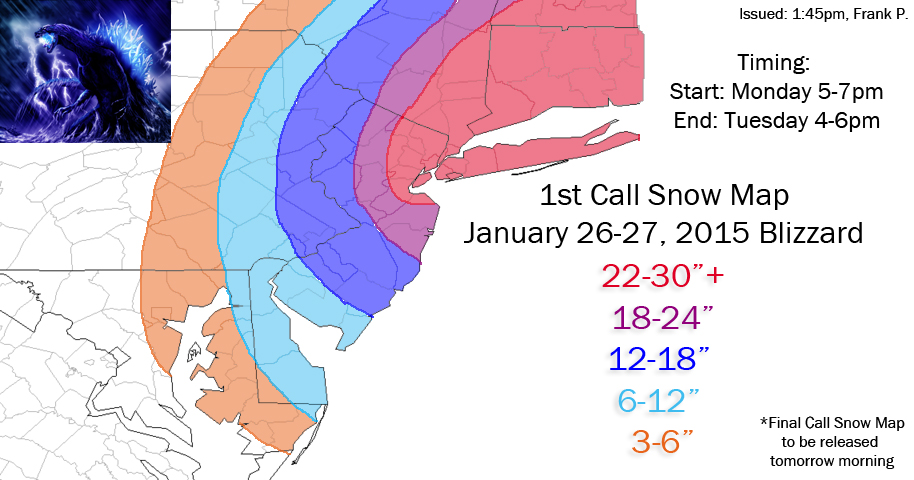
1st Call Snow Map, locally 3 FEET if you're in the red. Final Map tomorrow morning
_________________
_______________________________________________________________________________________________________
CLICK HERE to view NJ Strong Snowstorm Classifications
Frank_Wx- Godzilla Seeker
- Posts : 21305
Reputation : 328
Join date : 2013-01-05
Age : 31
Location : Jersey City, NJ -
Re: SNOW MAPS ONLY: MON JAN 26TH - JAN 27TH
![]() by Math23x7 Sun Jan 25, 2015 11:42 pm
by Math23x7 Sun Jan 25, 2015 11:42 pm
This is what I wrote on Facebook:
PLEASE READ DESCRIPTION BEFORE COMMENTING
This snow map had been my thinking for much of the day especially with the EURO being consistent the last several runs and bringing a blockbuster snowstorm to the NYC/LI region. With some of the model runs coming out tonight, they seem to trend weaker in terms of snow totals. Now, what's also difficult with any major snowstorm is wondering where the heavy snow bands will set up. It can be very local giving significantly higher accumulations than just outside the band. The "jackpot" region is where I think the big snow bands will set up. Of course that could shift any direction.
Also, I said I will update my snow map tomorrow morning to account for an analysis of tonight's EURO run. If it is steadfast with the storm, The high totals may remain. But if it caves, then these totals may be lowered BY A LOT.
SO What am I looking at now?
Light snow begins late tonight and goes through tomorrow afternoon with occasional moderate band from time to time. By late afternoon, it picks up in intensity and the brunt of the storm is from 8 PM tomorrow night to 8 AM Tuesday morning and light to moderate snow lingers for most of the morning and afternoon.
Anxious for when the EURO comes out at around 1 AM.
Math23x7- Wx Statistician Guru
- Posts : 2379
Reputation : 68
Join date : 2013-01-08
Re: SNOW MAPS ONLY: MON JAN 26TH - JAN 27TH
![]() by Guest Mon Jan 26, 2015 1:41 am
by Guest Mon Jan 26, 2015 1:41 am
Math23x7 wrote:This is what I wrote on Facebook:
PLEASE READ DESCRIPTION BEFORE COMMENTING
This snow map had been my thinking for much of the day especially with the EURO being consistent the last several runs and bringing a blockbuster snowstorm to the NYC/LI region. With some of the model runs coming out tonight, they seem to trend weaker in terms of snow totals. Now, what's also difficult with any major snowstorm is wondering where the heavy snow bands will set up. It can be very local giving significantly higher accumulations than just outside the band. The "jackpot" region is where I think the big snow bands will set up. Of course that could shift any direction.
Also, I said I will update my snow map tomorrow morning to account for an analysis of tonight's EURO run. If it is steadfast with the storm, The high totals may remain. But if it caves, then these totals may be lowered BY A LOT.
SO What am I looking at now?
Light snow begins late tonight and goes through tomorrow afternoon with occasional moderate band from time to time. By late afternoon, it picks up in intensity and the brunt of the storm is from 8 PM tomorrow night to 8 AM Tuesday morning and light to moderate snow lingers for most of the morning and afternoon.
Anxious for when the EURO comes out at around 1 AM.
Nice map buddy. Euro stayed strong. Stared down American models and doubled down.
Guest- Guest
Re: SNOW MAPS ONLY: MON JAN 26TH - JAN 27TH
![]() by Frank_Wx Mon Jan 26, 2015 1:45 am
by Frank_Wx Mon Jan 26, 2015 1:45 am
Hey Mike, I like your write-up and map. You cut-off area over the PA/NJ boarder actually makes sense.
_________________
_______________________________________________________________________________________________________
CLICK HERE to view NJ Strong Snowstorm Classifications
Frank_Wx- Godzilla Seeker
- Posts : 21305
Reputation : 328
Join date : 2013-01-05
Age : 31
Location : Jersey City, NJ -
Re: SNOW MAPS ONLY: MON JAN 26TH - JAN 27TH
![]() by Math23x7 Mon Jan 26, 2015 2:26 am
by Math23x7 Mon Jan 26, 2015 2:26 am
Thanks Frank. After seeing the 0Z EURO OP. I wrote this in the comment section:
Update: The EURO just came out and, like the other model runs tonight, shift the low east, BUT only slightly. In fact, yesterday afternoon's EURO had a snow band of over 2 feet for Passaic, Bergen, Rockland, and Orange counties. With the latest run, it shifts that band of snow over to Putnam, Westchester, Bronx, Queens, and Nassau Counties. Of course, I do wonder if this continues shifting eastward or remains intact because if the EURO run verified, Bellerose [NY] would have MORE snow than depicted here. HOWEVER, if any other the other models from tonight verifies, OR if tomorrow afternoon's EURO continues to shift the band eastward Bellerose [NY] would have LESS snow than depicted here. In a couple of hours, the 51 ensemble members will come out giving us more scenarios. However, I am not staying up for it. I need some sleep.
Update: The EURO just came out and, like the other model runs tonight, shift the low east, BUT only slightly. In fact, yesterday afternoon's EURO had a snow band of over 2 feet for Passaic, Bergen, Rockland, and Orange counties. With the latest run, it shifts that band of snow over to Putnam, Westchester, Bronx, Queens, and Nassau Counties. Of course, I do wonder if this continues shifting eastward or remains intact because if the EURO run verified, Bellerose [NY] would have MORE snow than depicted here. HOWEVER, if any other the other models from tonight verifies, OR if tomorrow afternoon's EURO continues to shift the band eastward Bellerose [NY] would have LESS snow than depicted here. In a couple of hours, the 51 ensemble members will come out giving us more scenarios. However, I am not staying up for it. I need some sleep.
Math23x7- Wx Statistician Guru
- Posts : 2379
Reputation : 68
Join date : 2013-01-08
Re: SNOW MAPS ONLY: MON JAN 26TH - JAN 27TH
![]() by oldtimer Mon Jan 26, 2015 2:40 am
by oldtimer Mon Jan 26, 2015 2:40 am
Paisan Frank You cant imagine how happy I am and you know what I am happy for, you So so glad you stuck to your guns Now I can sleep no matter what happens from here on in...........................
oldtimer- Senior Enthusiast
- Posts : 1103
Reputation : 14
Join date : 2013-01-16
Age : 78
Location : Port Jefferson Station Suffolk County
Re: SNOW MAPS ONLY: MON JAN 26TH - JAN 27TH
![]() by sroc4 Mon Jan 26, 2015 6:44 am
by sroc4 Mon Jan 26, 2015 6:44 am
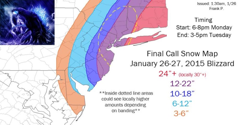
Folks I will lock this thread after this post so that the last thing you will view will be the final call maps only. We can continue the discussion of the storm over in the Final call thread Frank made. If anyone else has a map they would like me to include please post it in the other thread and PM me and I will move it here with the others. Great job by all.
FINAL CALL!!
Frank
 " />
" />
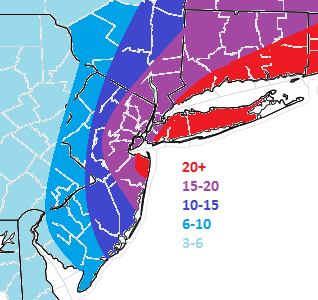
Mine
[img] [/img]
Ace
Math:
FINAL CALL!! Frank
" />Mine
[img]
[/img]Ace
Math:
_________________
"In weather and in life, there's no winning and losing; there's only winning and learning."
WINTER 2012/2013 TOTALS 43.65"WINTER 2017/2018 TOTALS 62.85" WINTER 2022/2023 TOTALS 4.9"
WINTER 2013/2014 TOTALS 64.85"WINTER 2018/2019 TOTALS 14.25" WINTER 2023/2024 TOTALS 13.1"
WINTER 2014/2015 TOTALS 71.20"WINTER 2019/2020 TOTALS 6.35"
WINTER 2015/2016 TOTALS 35.00"WINTER 2020/2021 TOTALS 37.75"
WINTER 2016/2017 TOTALS 42.25"WINTER 2021/2022 TOTALS 31.65"
sroc4- Admin
- Posts : 8331
Reputation : 301
Join date : 2013-01-07
Location : Wading River, LI
Re: SNOW MAPS ONLY: MON JAN 26TH - JAN 27TH
![]() by Frank_Wx Mon Jan 26, 2015 7:01 am
by Frank_Wx Mon Jan 26, 2015 7:01 am
Congrats Scott. You're jackpotting this storm. You suck
Best,
Frank
Best,
Frank
_________________
_______________________________________________________________________________________________________
CLICK HERE to view NJ Strong Snowstorm Classifications
Frank_Wx- Godzilla Seeker
- Posts : 21305
Reputation : 328
Join date : 2013-01-05
Age : 31
Location : Jersey City, NJ -
Permissions in this forum:
You cannot reply to topics in this forum|
|
|