
 Search
Update #1: From arctic freeze to possible Godzilla?
Page 1 of 14 • 1, 2, 3 ... 7 ... 14 ![]()

Update #1: From arctic freeze to possible Godzilla?
![]() by Frank_Wx Sun Feb 15, 2015 1:35 am
by Frank_Wx Sun Feb 15, 2015 1:35 am
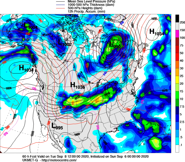
There is no rest for the weary here. There is yet another possible snowstorm in the not-so distant future. In fact, it could come this Tuesday and it actually has Godzilla potential. I will also go as far as saying that I am pretty confident someone is going to see a significant snowfall out of this.

The 00z GEFS 500mb height anomaly is a pretty impressive set-up for an east coast cyclogensis. Notice the ultimate 50/50 low in SE Canada which is our current weekend system. The PV is favorably placed over the Hudson and helping to force our northern stream energy to dive south over the eastern CONUS. Lastly, most impressive of all is the west ridge spike that extends into the EPO region. There are also higher heights showing up north of the 50/50 Low which will also help in setting up some blocking for this potential system. Overall, H5 looks really nice for getting an east coast storm this Tuesday.

The latest 00z EURO ejects a piece of southern energy out of the western U.S. and shoots it toward the east coast. Due to the confluence to our north, this piece of energy is able to dig into the trough a bit and allow heights to rise along the east coast. The surface low that forms in the southeast then has a clear path to tracking up the coast and bringing our area a sizable snow event. Between the large 50/50 and the higher heights just south of Greenland, there is a strong indication this storm will track just off or along the coast rather than escape out to sea.

Here was the latest EURO for Tuesday morning.
WHAT TO WATCH:
1. If there is phasing with northern stream energy in future runs, this could over-amplify the system which would bring a storm track much further west. Either up the apps or right on the coast. Obviously either track would bring precip. type issues to parts of the area. It's best we keep this just southern stream based.
2. How strong could this storm get? I have a feeling even though it may be just southern stream dominant, it may still be an impressive system. Between the block to our north and the Gulf helping to moisturize it, I could see it getting sub 990mb.
3. If the PV continues to come further south in the future, it may try to squash the southern stream energy which would result in a storm track out to sea regardless of the block we have. I do not see this happening, however.
I will have a detailed blog about this either tomorrow night or Monday afternoon.
Last edited by Frank_Wx on Sun Feb 15, 2015 11:39 pm; edited 1 time in total
_________________
_______________________________________________________________________________________________________
CLICK HERE to view NJ Strong Snowstorm Classifications

Frank_Wx- Godzilla Seeker

- Posts : 21305
Reputation : 328
Join date : 2013-01-05
Age : 31
Location : Jersey City, NJ -

Re: Update #1: From arctic freeze to possible Godzilla?
![]() by snow247 Sun Feb 15, 2015 1:42 am
by snow247 Sun Feb 15, 2015 1:42 am
Here's to hoping!

snow247- Pro Enthusiast

- Posts : 2417
Reputation : 0
Join date : 2014-08-27
Location : Mount Ivy, NY - Elevation 545'
Re: Update #1: From arctic freeze to possible Godzilla?
![]() by Artechmetals Sun Feb 15, 2015 1:55 am
by Artechmetals Sun Feb 15, 2015 1:55 am

Artechmetals- Pro Enthusiast
- Posts : 571
Reputation : 3
Join date : 2014-01-01
Age : 57
Location : Wayne , NJ
Re: Update #1: From arctic freeze to possible Godzilla?
![]() by Frank_Wx Sun Feb 15, 2015 1:56 am
by Frank_Wx Sun Feb 15, 2015 1:56 am
Artechmetals wrote:Frank nice write up , would that storm be more widespread than what we have been seeing
Yes, unless it's a glancing blow where only NYC and points east see snow. That would suck, wouldn't it?
_________________
_______________________________________________________________________________________________________
CLICK HERE to view NJ Strong Snowstorm Classifications
Frank_Wx- Godzilla Seeker
- Posts : 21305
Reputation : 328
Join date : 2013-01-05
Age : 31
Location : Jersey City, NJ -
Re: Update #1: From arctic freeze to possible Godzilla?
![]() by Artechmetals Sun Feb 15, 2015 1:59 am
by Artechmetals Sun Feb 15, 2015 1:59 am
Artechmetals- Pro Enthusiast
- Posts : 571
Reputation : 3
Join date : 2014-01-01
Age : 57
Location : Wayne , NJ
Re: Update #1: From arctic freeze to possible Godzilla?
![]() by Frank_Wx Sun Feb 15, 2015 2:01 am
by Frank_Wx Sun Feb 15, 2015 2:01 am

00z GGEM

00z UKMET
00z NAVGEM

_________________
_______________________________________________________________________________________________________
CLICK HERE to view NJ Strong Snowstorm Classifications
Frank_Wx- Godzilla Seeker
- Posts : 21305
Reputation : 328
Join date : 2013-01-05
Age : 31
Location : Jersey City, NJ -
Re: Update #1: From arctic freeze to possible Godzilla?
![]() by Frank_Wx Sun Feb 15, 2015 2:03 am
by Frank_Wx Sun Feb 15, 2015 2:03 am

_________________
_______________________________________________________________________________________________________
CLICK HERE to view NJ Strong Snowstorm Classifications
Frank_Wx- Godzilla Seeker
- Posts : 21305
Reputation : 328
Join date : 2013-01-05
Age : 31
Location : Jersey City, NJ -
Re: Update #1: From arctic freeze to possible Godzilla?
![]() by Artechmetals Sun Feb 15, 2015 2:05 am
by Artechmetals Sun Feb 15, 2015 2:05 am
Artechmetals- Pro Enthusiast
- Posts : 571
Reputation : 3
Join date : 2014-01-01
Age : 57
Location : Wayne , NJ
Re: Update #1: From arctic freeze to possible Godzilla?
![]() by docstox12 Sun Feb 15, 2015 2:26 am
by docstox12 Sun Feb 15, 2015 2:26 am

docstox12- Wx Statistician Guru

- Posts : 8507
Reputation : 222
Join date : 2013-01-07
Age : 73
Location : Monroe NY
Re: Update #1: From arctic freeze to possible Godzilla?
![]() by snow247 Sun Feb 15, 2015 2:45 am
by snow247 Sun Feb 15, 2015 2:45 am
snow247- Pro Enthusiast
- Posts : 2417
Reputation : 0
Join date : 2014-08-27
Location : Mount Ivy, NY - Elevation 545'
Re: Update #1: From arctic freeze to possible Godzilla?
![]() by 2004blackwrx Sun Feb 15, 2015 2:58 am
by 2004blackwrx Sun Feb 15, 2015 2:58 am
2004blackwrx- Pro Enthusiast
- Posts : 576
Reputation : 9
Join date : 2013-01-14
Location : Wappinger NY
Re: Update #1: From arctic freeze to possible Godzilla?
![]() by Guest Sun Feb 15, 2015 3:10 am
by Guest Sun Feb 15, 2015 3:10 am
Guest- Guest
Re: Update #1: From arctic freeze to possible Godzilla?
![]() by docstox12 Sun Feb 15, 2015 8:11 am
by docstox12 Sun Feb 15, 2015 8:11 am
docstox12- Wx Statistician Guru
- Posts : 8507
Reputation : 222
Join date : 2013-01-07
Age : 73
Location : Monroe NY
Re: Update #1: From arctic freeze to possible Godzilla?
![]() by amugs Sun Feb 15, 2015 8:16 am
by amugs Sun Feb 15, 2015 8:16 am
I have a really good feeling about his one and historically speaking the euro handles the southern vorts much better and we do much better with when the stj is pumping which it will with this and miller A's.
They usually over perform, that would be a nice change.

_________________
Mugs
AKA:King: Snow Weenie
Self Proclaimed
WINTER 2014-15 : 55.12" +.02 for 6 coatings (avg. 35")
WINTER 2015-16 Total - 29.8" (Avg 35")
WINTER 2016-17 : 39.5" so far

amugs- Advanced Forecaster - Mod

- Posts : 15093
Reputation : 213
Join date : 2013-01-07
Age : 54
Location : Hillsdale,NJ
Re: Update #1: From arctic freeze to possible Godzilla?
![]() by snow247 Sun Feb 15, 2015 8:39 am
by snow247 Sun Feb 15, 2015 8:39 am
snow247- Pro Enthusiast
- Posts : 2417
Reputation : 0
Join date : 2014-08-27
Location : Mount Ivy, NY - Elevation 545'
Re: Update #1: From arctic freeze to possible Godzilla?
![]() by billg315 Sun Feb 15, 2015 9:26 am
by billg315 Sun Feb 15, 2015 9:26 am

billg315- Advanced Forecaster - Mod
- Posts : 4469
Reputation : 185
Join date : 2015-01-24
Age : 50
Location : Flemington, NJ
Re: Update #1: From arctic freeze to possible Godzilla?
![]() by snow247 Sun Feb 15, 2015 9:28 am
by snow247 Sun Feb 15, 2015 9:28 am
snow247- Pro Enthusiast
- Posts : 2417
Reputation : 0
Join date : 2014-08-27
Location : Mount Ivy, NY - Elevation 545'
Re: Update #1: From arctic freeze to possible Godzilla?
![]() by snow247 Sun Feb 15, 2015 9:30 am
by snow247 Sun Feb 15, 2015 9:30 am
snow247- Pro Enthusiast
- Posts : 2417
Reputation : 0
Join date : 2014-08-27
Location : Mount Ivy, NY - Elevation 545'
Re: Update #1: From arctic freeze to possible Godzilla?
![]() by snow247 Sun Feb 15, 2015 9:31 am
by snow247 Sun Feb 15, 2015 9:31 am
snow247- Pro Enthusiast
- Posts : 2417
Reputation : 0
Join date : 2014-08-27
Location : Mount Ivy, NY - Elevation 545'
Re: Update #1: From arctic freeze to possible Godzilla?
![]() by snow247 Sun Feb 15, 2015 9:34 am
by snow247 Sun Feb 15, 2015 9:34 am
snow247- Pro Enthusiast
- Posts : 2417
Reputation : 0
Join date : 2014-08-27
Location : Mount Ivy, NY - Elevation 545'
Re: Update #1: From arctic freeze to possible Godzilla?
![]() by snow247 Sun Feb 15, 2015 9:36 am
by snow247 Sun Feb 15, 2015 9:36 am
snow247- Pro Enthusiast
- Posts : 2417
Reputation : 0
Join date : 2014-08-27
Location : Mount Ivy, NY - Elevation 545'
Re: Update #1: From arctic freeze to possible Godzilla?
![]() by snow247 Sun Feb 15, 2015 9:36 am
by snow247 Sun Feb 15, 2015 9:36 am
snow247- Pro Enthusiast
- Posts : 2417
Reputation : 0
Join date : 2014-08-27
Location : Mount Ivy, NY - Elevation 545'
Re: Update #1: From arctic freeze to possible Godzilla?
![]() by snow247 Sun Feb 15, 2015 9:40 am
by snow247 Sun Feb 15, 2015 9:40 am
snow247- Pro Enthusiast
- Posts : 2417
Reputation : 0
Join date : 2014-08-27
Location : Mount Ivy, NY - Elevation 545'
Re: Update #1: From arctic freeze to possible Godzilla?
![]() by snow247 Sun Feb 15, 2015 9:41 am
by snow247 Sun Feb 15, 2015 9:41 am
snow247- Pro Enthusiast
- Posts : 2417
Reputation : 0
Join date : 2014-08-27
Location : Mount Ivy, NY - Elevation 545'
Re: Update #1: From arctic freeze to possible Godzilla?
![]() by snow247 Sun Feb 15, 2015 9:44 am
by snow247 Sun Feb 15, 2015 9:44 am
snow247- Pro Enthusiast
- Posts : 2417
Reputation : 0
Join date : 2014-08-27
Location : Mount Ivy, NY - Elevation 545'
Page 1 of 14 • 1, 2, 3 ... 7 ... 14 ![]()