
 Search
Saturday December 17th 2016 Snow Storm--SNOW MAPS ONLY
3 posters

Saturday December 17th 2016 Snow Storm--SNOW MAPS ONLY
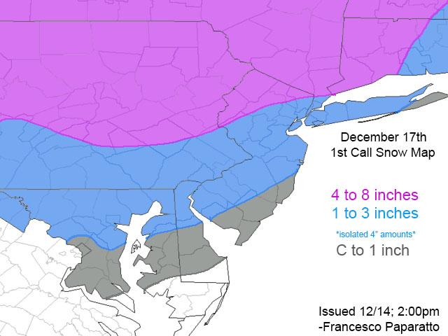
![]() by sroc4 Thu Dec 15, 2016 7:41 am
by sroc4 Thu Dec 15, 2016 7:41 am
_________________
"In weather and in life, there's no winning and losing; there's only winning and learning."
WINTER 2012/2013 TOTALS 43.65"WINTER 2017/2018 TOTALS 62.85" WINTER 2022/2023 TOTALS 4.9"
WINTER 2013/2014 TOTALS 64.85"WINTER 2018/2019 TOTALS 14.25" WINTER 2023/2024 TOTALS 13.1"
WINTER 2014/2015 TOTALS 71.20"WINTER 2019/2020 TOTALS 6.35"
WINTER 2015/2016 TOTALS 35.00"WINTER 2020/2021 TOTALS 37.75"
WINTER 2016/2017 TOTALS 42.25"WINTER 2021/2022 TOTALS 31.65"

sroc4- Admin

- Posts : 8331
Reputation : 301
Join date : 2013-01-07
Location : Wading River, LI
Re: Saturday December 17th 2016 Snow Storm--SNOW MAPS ONLY
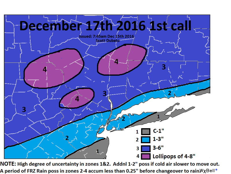
![]() by rb924119 Thu Dec 15, 2016 12:18 pm
by rb924119 Thu Dec 15, 2016 12:18 pm
First call for the Friday night-Saturday winter weather event:
Start: 11pm Friday-3am Saturday
End: 12-4pm Saturday
Look for flurries and light snow to begin breaking out across much of the region late tomorrow night and early Saturday morning. I am expecting that as the precipitation increases in coverage and intensity, the warm air aloft will be rapidly approaching from the south and east. As a result, kept snowfall amounts generally lighter and added some ice accretion, mainly for the higher terrain (as outlined by the areas of higher snow/sleet accumulations), seeing as though surface temperatures will likely lag the levels above with the speed at which they get above freezing. For all areas, this is likely going to end as plain and drizzle during the early-afternoon on Saturday. Any updates will be posted tomorrow as a final call.
To see the thought process behind my forecast, please watch the video at the link below:
https://drive.google.com/open?id=0Byod2Sk27yNYMG5zZlJCNEVnODA
rb924119- Meteorologist

- Posts : 6889
Reputation : 194
Join date : 2013-02-06
Age : 32
Location : Greentown, Pa
Re: Saturday December 17th 2016 Snow Storm--SNOW MAPS ONLY
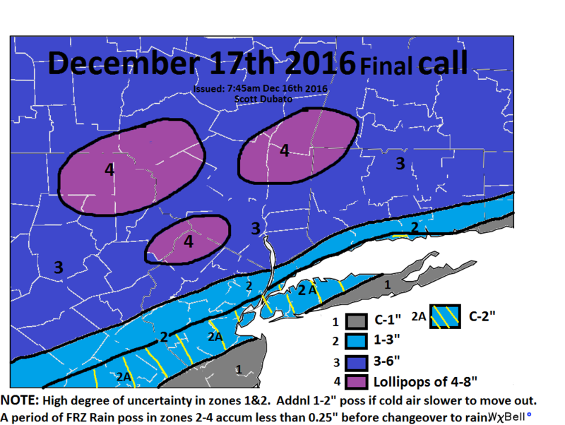
![]() by sroc4 Fri Dec 16, 2016 7:54 am
by sroc4 Fri Dec 16, 2016 7:54 am
Reasoning for my changes are in the other thread, but here is my final call.
_________________
"In weather and in life, there's no winning and losing; there's only winning and learning."
WINTER 2012/2013 TOTALS 43.65"WINTER 2017/2018 TOTALS 62.85" WINTER 2022/2023 TOTALS 4.9"
WINTER 2013/2014 TOTALS 64.85"WINTER 2018/2019 TOTALS 14.25" WINTER 2023/2024 TOTALS 13.1"
WINTER 2014/2015 TOTALS 71.20"WINTER 2019/2020 TOTALS 6.35"
WINTER 2015/2016 TOTALS 35.00"WINTER 2020/2021 TOTALS 37.75"
WINTER 2016/2017 TOTALS 42.25"WINTER 2021/2022 TOTALS 31.65"
sroc4- Admin
- Posts : 8331
Reputation : 301
Join date : 2013-01-07
Location : Wading River, LI
Re: Saturday December 17th 2016 Snow Storm--SNOW MAPS ONLY
![]() by Frank_Wx Fri Dec 16, 2016 11:22 am
by Frank_Wx Fri Dec 16, 2016 11:22 am
Final call

_________________
_______________________________________________________________________________________________________
CLICK HERE to view NJ Strong Snowstorm Classifications

Frank_Wx- Godzilla Seeker
- Posts : 21305
Reputation : 328
Join date : 2013-01-05
Age : 31
Location : Jersey City, NJ -

Permissions in this forum:
You cannot reply to topics in this forum|
|
|