
 Search
Long Range Thread 13.0
Page 1 of 40 • 1, 2, 3 ... 20 ... 40 ![]()

Long Range Thread 13.0
![]() by Frank_Wx Fri Dec 23, 2016 11:00 am
by Frank_Wx Fri Dec 23, 2016 11:00 am

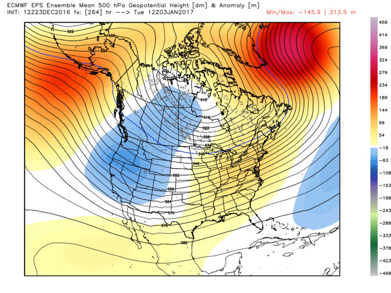
If you recall, the week of December 11th we saw a period of very cold conditions which ended with our first widespread snow event of the season on the 17th. The main contributing factor to that arctic outbreak was the emergence of a North Pacific ridge (-WPO/-EPO teleconnections). Generally, when Alaska is experiencing above normal temperature departures the CONUS is seeing colder than normal conditions. Here is a look at the 500mb heights for that week.

The reason I bring the week of the 11th up is because the pattern change around New Years Eve looks awfully similar.

The GEFS and EPS are in fair agreement the North Pacific ridge will make a comeback New Years Eve. On the 500mb height anomalies from the GEFS valid for NYE, notice the above normal height anomalies spreading across Alaska and western Canada. This signals for the return of a -EPO. Meanwhile, for the first time this winter, we're seeing positive height anomalies over the western U.S. which is defined as a +PNA. This puts the mean trough over the eastern U.S. which (if you compare to the first image of this post) now puts the coldest temperature departures on the east side of the country as opposed to the west.
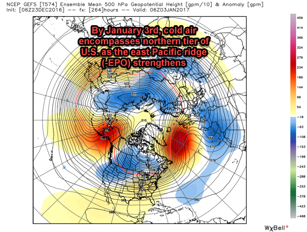
Continuing into January, the North Pacific ridge continues to show strength while the entire northern tier of the U.S. is under below normal temperature departures. Pay no attention to the orange shadings on this graphic. The heights contours suggest our area is still under the influence of a trough. Here are the temperature anomalies for January 3rd to prove it:
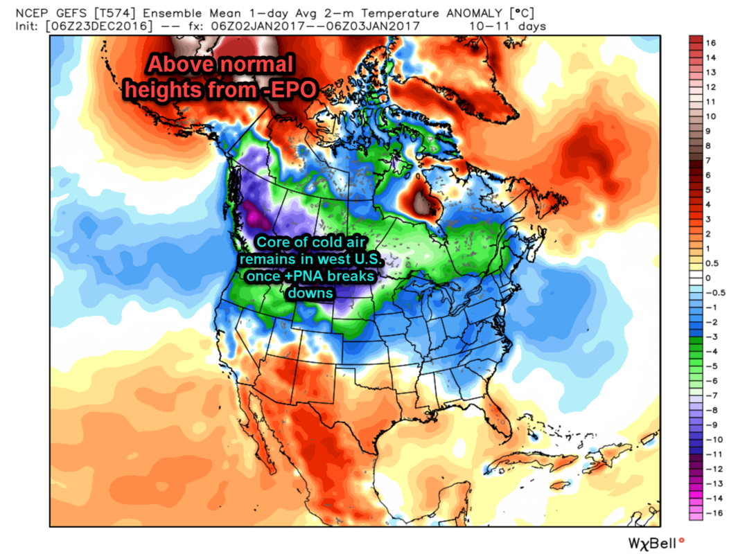
What you will notice is the western U.S. is back to seeing the coldest departures. This means the +PNA feature I mentioned around NYE is likely to be a temporary feature that quickly breaks down. Fortunately, the North Pacific ridge has staying power and gives our area a good chance to remain colder than normal for an extended period of time.
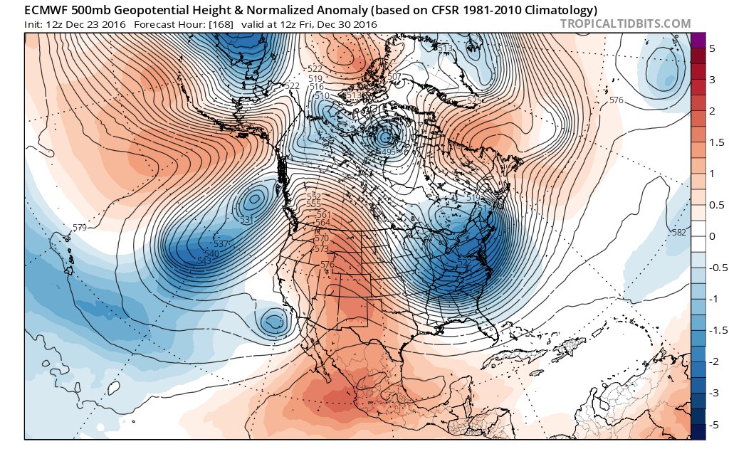
This said, the period between December 30th and January 8th looks like a good one for seeing colder than normal weather and our next chance of a widespread snowfall. I keep going back to the week of December 11th because that pattern resulted in our first widespread snow event of the season. With the NYE pattern change, there may be some high latitude blocking working in our favor as a result of the tropical forcing we're seeing out of the maritime continent. I am not buying any sustained periods of a -NAO at this time, I am thinking a psuedo-like block, but that could be enough to slow the flow down just a bit. I would not expect models to show any potential snowstorm threats in this time frame until we're within 5 days lead time.
In Italian, "piano piano se va lontano" is one of my favorite phrases my grandfather taught me. It means "go slowly, and you will go far." Truthfully, this is the best way to approach the winter season. A step down process that will take time to evolve. The NYE pattern change is another step that will have considerable affects in our Stratosphere (will talk about another time) and hopefully bring us closer to a pattern that looks less transient and more snowy.
Buon Natale e Felice Anno Nuovo a tutti miei amici.
-Francesco P.
_________________
_______________________________________________________________________________________________________
CLICK HERE to view NJ Strong Snowstorm Classifications

Frank_Wx- Godzilla Seeker

- Posts : 21305
Reputation : 328
Join date : 2013-01-05
Age : 31
Location : Jersey City, NJ -

Re: Long Range Thread 13.0
![]() by Bobby Martrich EPAWA Fri Dec 23, 2016 11:09 am
by Bobby Martrich EPAWA Fri Dec 23, 2016 11:09 am
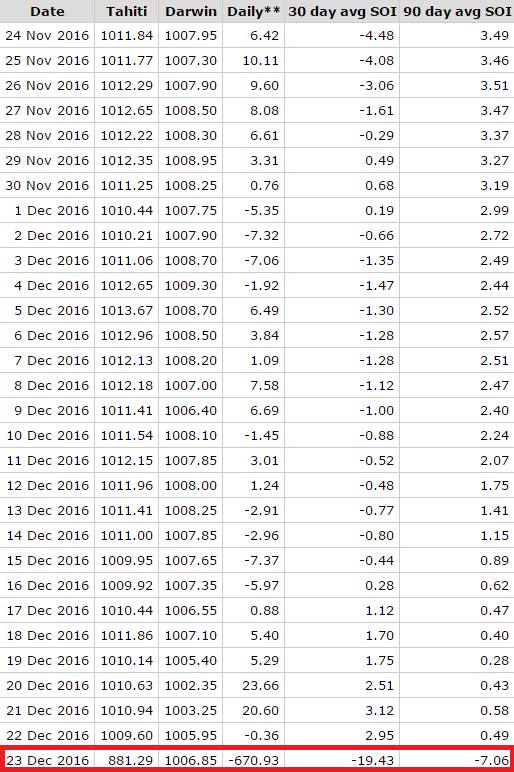
Is there some cat 5 super typhoon near Tahiti that is invisible to everyone?

Bobby Martrich EPAWA- Meteorologist

- Posts : 36
Reputation : 0
Join date : 2016-12-19
Location : Allentown, PA -
Re: Long Range Thread 13.0
![]() by Frank_Wx Fri Dec 23, 2016 11:11 am
by Frank_Wx Fri Dec 23, 2016 11:11 am
#prayfortahiti
_________________
_______________________________________________________________________________________________________
CLICK HERE to view NJ Strong Snowstorm Classifications
Frank_Wx- Godzilla Seeker
- Posts : 21305
Reputation : 328
Join date : 2013-01-05
Age : 31
Location : Jersey City, NJ -
Re: Long Range Thread 13.0
![]() by Frank_Wx Fri Dec 23, 2016 11:19 am
by Frank_Wx Fri Dec 23, 2016 11:19 am

_________________
_______________________________________________________________________________________________________
CLICK HERE to view NJ Strong Snowstorm Classifications
Frank_Wx- Godzilla Seeker
- Posts : 21305
Reputation : 328
Join date : 2013-01-05
Age : 31
Location : Jersey City, NJ -
Re: Long Range Thread 13.0
![]() by rb924119 Fri Dec 23, 2016 11:47 am
by rb924119 Fri Dec 23, 2016 11:47 am
Bobby Martrich EPAWA wrote:SOI looks good this morning... lol
Is there some cat 5 super typhoon near Tahiti that is invisible to everyone?
I questioned the validity of that this morning, myself ahaha I'm convinced it's the center of a black hole.
rb924119- Meteorologist
- Posts : 6889
Reputation : 194
Join date : 2013-02-06
Age : 32
Location : Greentown, Pa
rb924119- Meteorologist
- Posts : 6889
Reputation : 194
Join date : 2013-02-06
Age : 32
Location : Greentown, Pa
Re: Long Range Thread 13.0
![]() by Bobby Martrich EPAWA Fri Dec 23, 2016 12:12 pm
by Bobby Martrich EPAWA Fri Dec 23, 2016 12:12 pm
General idea is, increase the Arctic heights and maintain, forces the PV south longer, and with amplification from SOI drop might help with the storminess. -EPO/-WPO already does maintain on most guidance and ensembles. IF these favorable phases of the MJO can come to fruition, it can happen. Not sure if the GEFS depiction is correct with the phase 1 look or not, but as many have pointed out, they collectively missed the bus on the MJO P6 wave. Key takeaway on ALL guidance is a shift in tropical forcing away from the Maritime Continent. Whether it maintains is speculation, but we'll see.
Bobby Martrich EPAWA- Meteorologist
- Posts : 36
Reputation : 0
Join date : 2016-12-19
Location : Allentown, PA -
Re: Long Range Thread 13.0
![]() by sroc4 Fri Dec 23, 2016 12:39 pm
by sroc4 Fri Dec 23, 2016 12:39 pm
_________________
"In weather and in life, there's no winning and losing; there's only winning and learning."
WINTER 2012/2013 TOTALS 43.65"WINTER 2017/2018 TOTALS 62.85" WINTER 2022/2023 TOTALS 4.9"
WINTER 2013/2014 TOTALS 64.85"WINTER 2018/2019 TOTALS 14.25" WINTER 2023/2024 TOTALS 13.1"
WINTER 2014/2015 TOTALS 71.20"WINTER 2019/2020 TOTALS 6.35"
WINTER 2015/2016 TOTALS 35.00"WINTER 2020/2021 TOTALS 37.75"
WINTER 2016/2017 TOTALS 42.25"WINTER 2021/2022 TOTALS 31.65"

sroc4- Admin
- Posts : 8331
Reputation : 301
Join date : 2013-01-07
Location : Wading River, LI
Re: Long Range Thread 13.0
![]() by algae888 Fri Dec 23, 2016 12:46 pm
by algae888 Fri Dec 23, 2016 12:46 pm

algae888- Advanced Forecaster

- Posts : 5311
Reputation : 46
Join date : 2013-02-05
Age : 61
Location : mt. vernon, new york
Re: Long Range Thread 13.0
![]() by Frank_Wx Fri Dec 23, 2016 2:14 pm
by Frank_Wx Fri Dec 23, 2016 2:14 pm
Last edited by Frank_Wx on Fri Dec 23, 2016 2:36 pm; edited 1 time in total
_________________
_______________________________________________________________________________________________________
CLICK HERE to view NJ Strong Snowstorm Classifications
Frank_Wx- Godzilla Seeker
- Posts : 21305
Reputation : 328
Join date : 2013-01-05
Age : 31
Location : Jersey City, NJ -
Re: Long Range Thread 13.0
![]() by algae888 Fri Dec 23, 2016 2:26 pm
by algae888 Fri Dec 23, 2016 2:26 pm
algae888- Advanced Forecaster
- Posts : 5311
Reputation : 46
Join date : 2013-02-05
Age : 61
Location : mt. vernon, new york
Re: Long Range Thread 13.0
![]() by Frank_Wx Fri Dec 23, 2016 2:37 pm
by Frank_Wx Fri Dec 23, 2016 2:37 pm

_________________
_______________________________________________________________________________________________________
CLICK HERE to view NJ Strong Snowstorm Classifications
Frank_Wx- Godzilla Seeker
- Posts : 21305
Reputation : 328
Join date : 2013-01-05
Age : 31
Location : Jersey City, NJ -
Re: Long Range Thread 13.0
![]() by Frank_Wx Fri Dec 23, 2016 2:42 pm
by Frank_Wx Fri Dec 23, 2016 2:42 pm
https://twitter.com/nj_strong_wx/status/812382313078210564
_________________
_______________________________________________________________________________________________________
CLICK HERE to view NJ Strong Snowstorm Classifications
Frank_Wx- Godzilla Seeker
- Posts : 21305
Reputation : 328
Join date : 2013-01-05
Age : 31
Location : Jersey City, NJ -
Re: Long Range Thread 13.0
![]() by sroc4 Fri Dec 23, 2016 2:43 pm
by sroc4 Fri Dec 23, 2016 2:43 pm
Frank_Wx wrote:Yes, the 29th EURO has a Babyzilla
It looks like a Miller B system. Secondary Pops immed. south of LI. Nice PNA ridge with HP to the N. Its the time frame highlighted in the prev discussions.


_________________
"In weather and in life, there's no winning and losing; there's only winning and learning."
WINTER 2012/2013 TOTALS 43.65"WINTER 2017/2018 TOTALS 62.85" WINTER 2022/2023 TOTALS 4.9"
WINTER 2013/2014 TOTALS 64.85"WINTER 2018/2019 TOTALS 14.25" WINTER 2023/2024 TOTALS 13.1"
WINTER 2014/2015 TOTALS 71.20"WINTER 2019/2020 TOTALS 6.35"
WINTER 2015/2016 TOTALS 35.00"WINTER 2020/2021 TOTALS 37.75"
WINTER 2016/2017 TOTALS 42.25"WINTER 2021/2022 TOTALS 31.65"
sroc4- Admin
- Posts : 8331
Reputation : 301
Join date : 2013-01-07
Location : Wading River, LI
Re: Long Range Thread 13.0
![]() by sroc4 Fri Dec 23, 2016 2:45 pm
by sroc4 Fri Dec 23, 2016 2:45 pm
Frank_Wx wrote:Announcement
https://twitter.com/nj_strong_wx/status/812382313078210564
If you look the energy that we talked about in prev discussions with Ray in the SW conus causing the PNA ridge to be dampened is modeled to be off the SW CONUS now which would leave room for PNA ridge amplification from the ULL off the NW Coast
_________________
"In weather and in life, there's no winning and losing; there's only winning and learning."
WINTER 2012/2013 TOTALS 43.65"WINTER 2017/2018 TOTALS 62.85" WINTER 2022/2023 TOTALS 4.9"
WINTER 2013/2014 TOTALS 64.85"WINTER 2018/2019 TOTALS 14.25" WINTER 2023/2024 TOTALS 13.1"
WINTER 2014/2015 TOTALS 71.20"WINTER 2019/2020 TOTALS 6.35"
WINTER 2015/2016 TOTALS 35.00"WINTER 2020/2021 TOTALS 37.75"
WINTER 2016/2017 TOTALS 42.25"WINTER 2021/2022 TOTALS 31.65"
sroc4- Admin
- Posts : 8331
Reputation : 301
Join date : 2013-01-07
Location : Wading River, LI
Re: Long Range Thread 13.0
![]() by Frank_Wx Fri Dec 23, 2016 2:53 pm
by Frank_Wx Fri Dec 23, 2016 2:53 pm

_________________
_______________________________________________________________________________________________________
CLICK HERE to view NJ Strong Snowstorm Classifications
Frank_Wx- Godzilla Seeker
- Posts : 21305
Reputation : 328
Join date : 2013-01-05
Age : 31
Location : Jersey City, NJ -
Re: Long Range Thread 13.0
![]() by Armando Salvadore Fri Dec 23, 2016 3:15 pm
by Armando Salvadore Fri Dec 23, 2016 3:15 pm
Great Stuff Frank. Decided to join the forum since i've recently found out about it and forgot you initiated one a while back. I see Bobby M. is on here too. Fantastic! I'll contribute and post some technical things and join in on the conversations! The 200mb CHI emancipating the beginning to the pacific change from East Asia, as a wave train begins to set up. No need to say much more since its been stated by several. Interesting time period between the 29th-2nd, as PVA implements from pacific jet as the polar jet dives down. Question is, do we see enough confluence to slow it down to see an earlier transfer, or do we get sufficient digging from what appears to be a rex block setting up over the west. 12z EURO handles the ridge differently than the GFS, hence more of a digging trough and colder solution. Difference in confluence as well near SE Canada.

Armando Salvadore- Advanced Forecaster
- Posts : 171
Reputation : 0
Join date : 2016-12-23
Location : Springfield, NJ
Re: Long Range Thread 13.0
![]() by sroc4 Fri Dec 23, 2016 3:52 pm
by sroc4 Fri Dec 23, 2016 3:52 pm
Frank_Wx wrote:Yea Scott, and look at the GFS valid same time frame. Completely different ridge handling.
Yeah Completely different look off the NW Coast, western Coast of Canada and into Alaska. GFS has a super Rex block in the GOA vs Much sharper/ shorter wavelength on the Euro


_________________
"In weather and in life, there's no winning and losing; there's only winning and learning."
WINTER 2012/2013 TOTALS 43.65"WINTER 2017/2018 TOTALS 62.85" WINTER 2022/2023 TOTALS 4.9"
WINTER 2013/2014 TOTALS 64.85"WINTER 2018/2019 TOTALS 14.25" WINTER 2023/2024 TOTALS 13.1"
WINTER 2014/2015 TOTALS 71.20"WINTER 2019/2020 TOTALS 6.35"
WINTER 2015/2016 TOTALS 35.00"WINTER 2020/2021 TOTALS 37.75"
WINTER 2016/2017 TOTALS 42.25"WINTER 2021/2022 TOTALS 31.65"
sroc4- Admin
- Posts : 8331
Reputation : 301
Join date : 2013-01-07
Location : Wading River, LI
Re: Long Range Thread 13.0
![]() by Bobby Martrich EPAWA Fri Dec 23, 2016 3:59 pm
by Bobby Martrich EPAWA Fri Dec 23, 2016 3:59 pm
Someone want to explain to me how this is possible to have SE ridge look like this in this set-up? Not possible with -EPO/-WPO/-NAO and PV in ideal spot over Hudson Bay.
Like I said earlier in this thread, this is why I kept it near normal first week of January after the New Year's cold shot. Obvious model confusion.
Bobby Martrich EPAWA- Meteorologist
- Posts : 36
Reputation : 0
Join date : 2016-12-19
Location : Allentown, PA -
Re: Long Range Thread 13.0
![]() by rb924119 Fri Dec 23, 2016 4:46 pm
by rb924119 Fri Dec 23, 2016 4:46 pm
Bobby Martrich EPAWA wrote:Meanwhile... the Euro EPS today somehow rewrites the laws of physics.
Someone want to explain to me how this is possible to have SE ridge look like this in this set-up? Not possible with -EPO/-WPO/-NAO and PV in ideal spot over Hudson Bay.
Like I said earlier in this thread, this is why I kept it near normal first week of January after the New Year's cold shot. Obvious model confusion.
It's all because of the erroneous model feedback mechanisms that it's doing this. The problem is that it's trying to slam the west coast with the trough, but then bring some of that energy (remember, the individual members can vary) eastward. As the energy is pushed east the model is sensing the lift over the mountains, and knows that when cold air is lifted it gets colder, which is why it keeps trying to put the main trough axis over the west. As a result, regardless of the Northern Hemispheric configuration, because it keeps feeding back and deepening the western U.S. trough, that signal overwhelms the rest of them for the eastern U.S. and results in the "ridging" on the modeling. However, since you know the model bias and understand how things should play out based on the larger Northern Hemispheric configuration, you can know where the model will be headed; similar pattern to what we see evolve starting next week.
rb924119- Meteorologist
- Posts : 6889
Reputation : 194
Join date : 2013-02-06
Age : 32
Location : Greentown, Pa
Re: Long Range Thread 13.0
![]() by Frank_Wx Fri Dec 23, 2016 5:05 pm
by Frank_Wx Fri Dec 23, 2016 5:05 pm
Armando Salvadore wrote:
Great Stuff Frank. Decided to join the forum since i've recently found out about it and forgot you initiated one a while back. I see Bobby M. is on here too. Fantastic! I'll contribute and post some technical things and join in on the conversations! The 200mb CHI emancipating the beginning to the pacific change from East Asia, as a wave train begins to set up. No need to say much more since its been stated by several. Interesting time period between the 29th-2nd, as PVA implements from pacific jet as the polar jet dives down. Question is, do we see enough confluence to slow it down to see an earlier transfer, or do we get sufficient digging from what appears to be a rex block setting up over the west. 12z EURO handles the ridge differently than the GFS, hence more of a digging trough and colder solution. Difference in confluence as well near SE Canada.
Welcome Armando! Nice summary. The time period you mentioned is one we'll all be keeping a very close eye on. I hope the amplification EURO shows out west is correct. Would put us in business. Sroc put our a good post showing the difference between the two.
rb924119 wrote:Bobby Martrich EPAWA wrote:Meanwhile... the Euro EPS today somehow rewrites the laws of physics.
Someone want to explain to me how this is possible to have SE ridge look like this in this set-up? Not possible with -EPO/-WPO/-NAO and PV in ideal spot over Hudson Bay.
Like I said earlier in this thread, this is why I kept it near normal first week of January after the New Year's cold shot. Obvious model confusion.
It's all because of the erroneous model feedback mechanisms that it's doing this. The problem is that it's trying to slam the west coast with the trough, but then bring some of that energy (remember, the individual members can vary) eastward. As the energy is pushed east the model is sensing the lift over the mountains, and knows that when cold air is lifted it gets colder, which is why it keeps trying to put the main trough axis over the west. As a result, regardless of the Northern Hemispheric configuration, because it keeps feeding back and deepening the western U.S. trough, that signal overwhelms the rest of them for the eastern U.S. and results in the "ridging" on the modeling. However, since you know the model bias and understand how things should play out based on the larger Northern Hemispheric configuration, you can know where the model will be headed; similar pattern to what we see evolve starting next week.
Great post.
_________________
_______________________________________________________________________________________________________
CLICK HERE to view NJ Strong Snowstorm Classifications
Frank_Wx- Godzilla Seeker
- Posts : 21305
Reputation : 328
Join date : 2013-01-05
Age : 31
Location : Jersey City, NJ -
Re: Long Range Thread 13.0
![]() by sroc4 Fri Dec 23, 2016 5:40 pm
by sroc4 Fri Dec 23, 2016 5:40 pm
rb924119 wrote:Bobby Martrich EPAWA wrote:Meanwhile... the Euro EPS today somehow rewrites the laws of physics.
Someone want to explain to me how this is possible to have SE ridge look like this in this set-up? Not possible with -EPO/-WPO/-NAO and PV in ideal spot over Hudson Bay.
Like I said earlier in this thread, this is why I kept it near normal first week of January after the New Year's cold shot. Obvious model confusion.
It's all because of the erroneous model feedback mechanisms that it's doing this. The problem is that it's trying to slam the west coast with the trough, but then bring some of that energy (remember, the individual members can vary) eastward. As the energy is pushed east the model is sensing the lift over the mountains, and knows that when cold air is lifted it gets colder, which is why it keeps trying to put the main trough axis over the west. As a result, regardless of the Northern Hemispheric configuration, because it keeps feeding back and deepening the western U.S. trough, that signal overwhelms the rest of them for the eastern U.S. and results in the "ridging" on the modeling. However, since you know the model bias and understand how things should play out based on the larger Northern Hemispheric configuration, you can know where the model will be headed; similar pattern to what we see evolve starting next week.
I was simply going to point out the known bias of holding back energy in the west on this model. This is much better. Just like what the Dec 30th time frame looks like if the blocking is correct as we get in under 10days one would expect a piece of that mean trough to back up off the coast and a second piece to dig into the central plains and east coast with ridging of some sort in the west
_________________
"In weather and in life, there's no winning and losing; there's only winning and learning."
WINTER 2012/2013 TOTALS 43.65"WINTER 2017/2018 TOTALS 62.85" WINTER 2022/2023 TOTALS 4.9"
WINTER 2013/2014 TOTALS 64.85"WINTER 2018/2019 TOTALS 14.25" WINTER 2023/2024 TOTALS 13.1"
WINTER 2014/2015 TOTALS 71.20"WINTER 2019/2020 TOTALS 6.35"
WINTER 2015/2016 TOTALS 35.00"WINTER 2020/2021 TOTALS 37.75"
WINTER 2016/2017 TOTALS 42.25"WINTER 2021/2022 TOTALS 31.65"
sroc4- Admin
- Posts : 8331
Reputation : 301
Join date : 2013-01-07
Location : Wading River, LI
Re: Long Range Thread 13.0
![]() by sroc4 Sat Dec 24, 2016 8:29 am
by sroc4 Sat Dec 24, 2016 8:29 am
Overall it looks like on both models Euro and GFS the handling of the ridging into Alaska has been about the same with very subtle differences. One difference I'm seeing between models as well as run to run on any given model is differences in the Upper level energy immediately to the south of the Alaska Ridging. Overall the euro has been more consistent in the placement, and intensity of this energy relative to the GFS. Ultimately the Alaska Ridge and trough to the south combo creates a Rex block which will help to prevent the direct invasion of warmer Pacific air into NA. It forces the flow from the Pac up into the colder latitudes before dipping south into the CONUS (as a gen rule). The upper level LP associated with the Rex Block also will play a role in how amped the western ridge can get. (http://www.theweatherprediction.com/habyhints/178/)

I am noticing a trend; however, in the PNA region(Western CONUS); not for the better. If we look at the Euro Op, you will notice the West coast ridging is becoming less amped or flatter with successive runs. Not good if we want northern stream energy to dig into the backside of the trough sharpening it leading to cyclogenesis somewhere along the coast. The flatter the ridge in the west, the broader the trough in the east. The broader the trough, the weaker the surface LP and more progressive the flow off the EC. The western ridge is extremely important for this particular set up because the north Atlantic ridging that we have been discussing will not be set up very well by this time frame. Maybe in the time frame between the 2nd and 5th less importance on he western ridge will be needed If the NA blocking becomes better established, but that's a diff discussion.
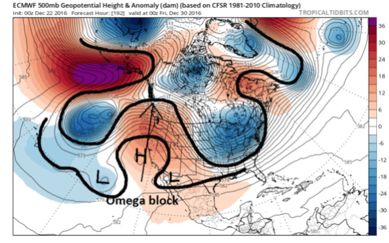
On the 00z Euro valid Dec 22nd you will notice the SW CONUS has an Omega block type set up leading to a decent ridge. (http://www.theweatherprediction.com/habyhints/144/)
On the 00z Euro valid Dec 23rd you will notice that there is practically no upper level energy in the SW leading to the best western ridging and consequently the sharpest and deepest eastern trough of the last 3 runs.

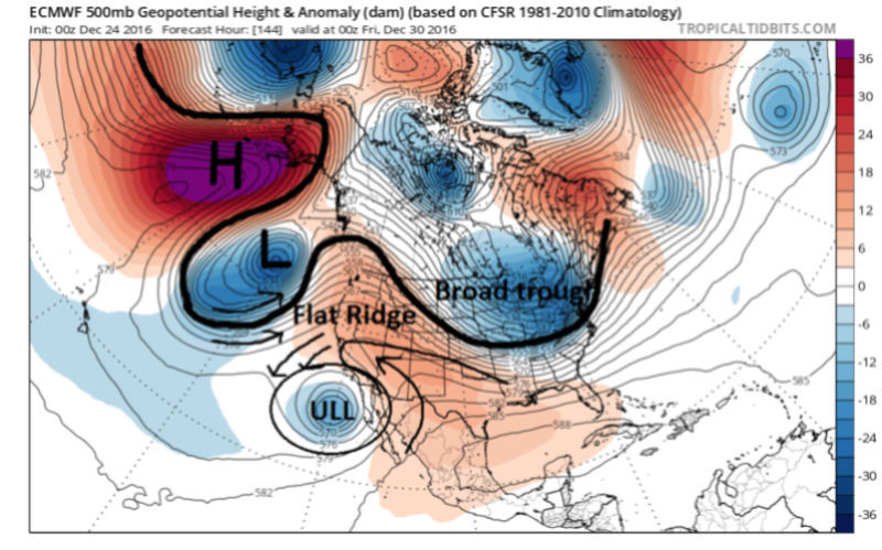
And finally last nights 00z Euro valid Dec 24th. Notice now there is a strong ULL (upper level low) just off the SW CONUS/Baha region. The strength of the ULL wants to lower heights along the back side of it because of the natural counterclockwise flow. In essence the energy off the SW coast steals some of the ability of the ULL associated with the Rex block we highlighted above off the NW conus, from raising heights and pumping the western ridge out ahead of IT.
Clearly the model is still trying to figure out the upper level pattern, but the idea of having some sort of energy in the SW CONUS region is highly likely as it is showing up in some fashion on both GFS and Euro Ops as well as their ensemble means. How strong and exactly where this energy is centered will play a role in the overall soln to the strength of the west coast ridge which likely dictates how strong of a storm threat we really have for this time frame. That said we still also have to watch the trends out ahead of the approaching trough to our N and E; up into the Atlantic and SE Canada, confluence etc. as well.
Here are the last three 00z runs for both Euro and GFS lined up without any writing on them so you can see for yourselves the differences in the regions I highlighted above.
Have a VERY MERRY CHRISTMAS
LAST 3 00Z EURO OP:


LAST 3 00Z GFS


_________________
"In weather and in life, there's no winning and losing; there's only winning and learning."
WINTER 2012/2013 TOTALS 43.65"WINTER 2017/2018 TOTALS 62.85" WINTER 2022/2023 TOTALS 4.9"
WINTER 2013/2014 TOTALS 64.85"WINTER 2018/2019 TOTALS 14.25" WINTER 2023/2024 TOTALS 13.1"
WINTER 2014/2015 TOTALS 71.20"WINTER 2019/2020 TOTALS 6.35"
WINTER 2015/2016 TOTALS 35.00"WINTER 2020/2021 TOTALS 37.75"
WINTER 2016/2017 TOTALS 42.25"WINTER 2021/2022 TOTALS 31.65"
sroc4- Admin
- Posts : 8331
Reputation : 301
Join date : 2013-01-07
Location : Wading River, LI
Re: Long Range Thread 13.0
![]() by rb924119 Sat Dec 24, 2016 9:45 am
by rb924119 Sat Dec 24, 2016 9:45 am
I don't know how much I'll be posting over the next few days, but as you said and I'll re-echo: Merry Christmas everybody!!
rb924119- Meteorologist
- Posts : 6889
Reputation : 194
Join date : 2013-02-06
Age : 32
Location : Greentown, Pa
Re: Long Range Thread 13.0
![]() by sroc4 Sat Dec 24, 2016 9:52 am
by sroc4 Sat Dec 24, 2016 9:52 am
rb924119 wrote:Great summary and discussion!! Just to clarify, the Aleutian ridge isn't a Rex block; it's more of an omega. The actual Rex block is in the PNA region as the upper-level low slips beneath the ridge. That's the Rex block I referenced a couple of days ago.
I don't know how much I'll be posting over the next few days, but as you said and I'll re-echo: Merry Christmas everybody!!
Thanks for clarifying so is it 90degrees turned right to see the omega? I was under the impression that a High over top of a low was Rex?
_________________
"In weather and in life, there's no winning and losing; there's only winning and learning."
WINTER 2012/2013 TOTALS 43.65"WINTER 2017/2018 TOTALS 62.85" WINTER 2022/2023 TOTALS 4.9"
WINTER 2013/2014 TOTALS 64.85"WINTER 2018/2019 TOTALS 14.25" WINTER 2023/2024 TOTALS 13.1"
WINTER 2014/2015 TOTALS 71.20"WINTER 2019/2020 TOTALS 6.35"
WINTER 2015/2016 TOTALS 35.00"WINTER 2020/2021 TOTALS 37.75"
WINTER 2016/2017 TOTALS 42.25"WINTER 2021/2022 TOTALS 31.65"
sroc4- Admin
- Posts : 8331
Reputation : 301
Join date : 2013-01-07
Location : Wading River, LI
Page 1 of 40 • 1, 2, 3 ... 20 ... 40 ![]()
|
|
|