
 Search
January 22nd-24th Nor'easter Observations & Discussions
Page 4 of 43 •  1, 2, 3, 4, 5 ... 23 ... 43
 ![]()
Re: January 22nd-24th Nor'easter Observations & Discussions
![]() by jmanley32 Sat Jan 21, 2017 8:09 pm
by jmanley32 Sat Jan 21, 2017 8:09 pm
Franks scroll and storm mode does not merit a meh from him I'm sure. He says meh when nothing happens. Dev I agree. Let's see how everyone feels tuesday. Msybe it will b no big deal but there are crazy dynamics at play here.devsman wrote:Losing power with 40 degree temps is meh? Ok
jmanley32- Senior Enthusiast

- Posts : 20513
Join date : 2013-12-12
Re: January 22nd-24th Nor'easter Observations & Discussions
![]() by jmanley32 Sat Jan 21, 2017 8:13 pm
by jmanley32 Sat Jan 21, 2017 8:13 pm
just err on side of caution. No one has really hyped including me I've shown maps and th ey are impressive. Also losing power in a apartment building is so much worse than a house.syosnow94 wrote:Don't foresee losing power. If I do I have a wood burning stove!!
jmanley32- Senior Enthusiast
- Posts : 20513
Join date : 2013-12-12
Re: January 22nd-24th Nor'easter Observations & Discussions
![]() by Guest Sat Jan 21, 2017 8:14 pm
by Guest Sat Jan 21, 2017 8:14 pm
Guest- Guest
Re: January 22nd-24th Nor'easter Observations & Discussions
![]() by track17 Sat Jan 21, 2017 8:14 pm
by track17 Sat Jan 21, 2017 8:14 pm
track17- Posts : 454
Reputation : 4
Join date : 2016-01-09
Re: January 22nd-24th Nor'easter Observations & Discussions
![]() by jmanley32 Sat Jan 21, 2017 8:16 pm
by jmanley32 Sat Jan 21, 2017 8:16 pm
those are upper air winds though much will mix down 80 mph probably wont.weatherwatchermom wrote:jmanley32 wrote:oh tgats white damaging alright jeeze.[/quotskinsfan1177 wrote:Tell me that's not damaging
oh boy that would be damaging I am in that lavender color...not good if that comes to fruition...that would put us over 80 mph...during that time frame


jmanley32- Senior Enthusiast
- Posts : 20513
Reputation : 108
Join date : 2013-12-12
Age : 42
Location : Yonkers, NY
Re: January 22nd-24th Nor'easter Observations & Discussions
![]() by jmanley32 Sat Jan 21, 2017 8:25 pm
by jmanley32 Sat Jan 21, 2017 8:25 pm
jmanley32- Senior Enthusiast
- Posts : 20513
Reputation : 108
Join date : 2013-12-12
Age : 42
Location : Yonkers, NY
Re: January 22nd-24th Nor'easter Observations & Discussions
![]() by amugs Sat Jan 21, 2017 9:05 pm
by amugs Sat Jan 21, 2017 9:05 pm
On another board we have pro mets there saying how this is going to be an impactful and serious storm.
Looking at the 25 tornados in the south is an indication of how dynamic and serious this storm is now.
If u don't agree fine but PLEASE do not downplay this storm at this time. Even NWS is starting to harp
Janet awesome job with the soundings and they are going to trend colder imwo!!
_________________
Mugs
AKA:King: Snow Weenie
Self Proclaimed
WINTER 2014-15 : 55.12" +.02 for 6 coatings (avg. 35")
WINTER 2015-16 Total - 29.8" (Avg 35")
WINTER 2016-17 : 39.5" so far

amugs- Advanced Forecaster - Mod

- Posts : 15093
Reputation : 213
Join date : 2013-01-07
Age : 54
Location : Hillsdale,NJ
Re: January 22nd-24th Nor'easter Observations & Discussions
![]() by devsman Sat Jan 21, 2017 9:10 pm
by devsman Sat Jan 21, 2017 9:10 pm

devsman- Pro Enthusiast

- Posts : 424
Reputation : 4
Join date : 2014-01-01
Age : 48
Location : merrick, ny (south shore of Long Island)
Re: January 22nd-24th Nor'easter Observations & Discussions
![]() by jmanley32 Sat Jan 21, 2017 9:14 pm
by jmanley32 Sat Jan 21, 2017 9:14 pm
amugs wrote:A SYO AND TRACK this is s NOT a meh storm for u or many if not all on this board. 35-40mph sustained winds with 60 mph plus gusts to possibly hcane force which are not out of the realm are NOT MEH. Also those knots maps at 850 will mix down and take knots and multiply by 1.3 to get mph. Will you lose some strength yes but not a lot at minimum take 80% of that.
On another board we have pro mets there saying how this is going to be an impactful and serious storm.
Looking at the 25 tornados in the south is an indication of how dynamic and serious this storm is now.
If u don't agree fine but PLEASE do not downplay this storm at this time. Even NWS is starting to harp
Janet awesome job with the soundings and they are going to trend colder imwo!!
My man, yes totally agree, and 00z NAM is coming in deeper! Out to hr 33. Looks more well defined too. You really think 80% of 850mb winds will mix to the surface? That doesn't happen too often. If so thats serious.
Last edited by jmanley32 on Sat Jan 21, 2017 9:24 pm; edited 1 time in total
jmanley32- Senior Enthusiast
- Posts : 20513
Reputation : 108
Join date : 2013-12-12
Age : 42
Location : Yonkers, NY
Re: January 22nd-24th Nor'easter Observations & Discussions
![]() by jmanley32 Sat Jan 21, 2017 9:16 pm
by jmanley32 Sat Jan 21, 2017 9:16 pm
jmanley32- Senior Enthusiast
- Posts : 20513
Reputation : 108
Join date : 2013-12-12
Age : 42
Location : Yonkers, NY
Re: January 22nd-24th Nor'easter Observations & Discussions
![]() by Joe Snow Sat Jan 21, 2017 9:27 pm
by Joe Snow Sat Jan 21, 2017 9:27 pm
http://www.weather.gov/media/okx/Briefings/CoastalStormBriefing.pdf

Joe Snow- Pro Enthusiast
- Posts : 924
Reputation : 7
Join date : 2014-02-12
Age : 62
Location : Sanford Florida, Fmrly Kings Park, NY
Re: January 22nd-24th Nor'easter Observations & Discussions
![]() by jmanley32 Sat Jan 21, 2017 9:28 pm
by jmanley32 Sat Jan 21, 2017 9:28 pm
jmanley32- Senior Enthusiast
- Posts : 20513
Reputation : 108
Join date : 2013-12-12
Age : 42
Location : Yonkers, NY
Re: January 22nd-24th Nor'easter Observations & Discussions
![]() by jmanley32 Sat Jan 21, 2017 9:32 pm
by jmanley32 Sat Jan 21, 2017 9:32 pm
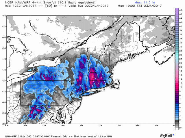
I fully expect those numbers to go up in the morning briefing they are planning, NAM is coming in very intense with 925mb winds even reaching 75+ knots sustained. And lookie here, maybe its sleet but wow.Joe Snow wrote:And here is the NWS Briefing:
http://www.weather.gov/media/okx/Briefings/CoastalStormBriefing.pdf

jmanley32- Senior Enthusiast
- Posts : 20513
Reputation : 108
Join date : 2013-12-12
Age : 42
Location : Yonkers, NY
Re: January 22nd-24th Nor'easter Observations & Discussions
![]() by jmanley32 Sat Jan 21, 2017 9:35 pm
by jmanley32 Sat Jan 21, 2017 9:35 pm

jmanley32- Senior Enthusiast
- Posts : 20513
Reputation : 108
Join date : 2013-12-12
Age : 42
Location : Yonkers, NY
Re: January 22nd-24th Nor'easter Observations & Discussions
![]() by docstox12 Sat Jan 21, 2017 9:45 pm
by docstox12 Sat Jan 21, 2017 9:45 pm
sroc4 wrote:docstox12 wrote:amugs wrote:Peeps,
This LP/storm si over performing as we speak in the deep south with great convection and Tornadoes all over Miss and Bama.
Joe B still harping on 1-3" for NYC Metro and 3-6 in N & W areas with 6" plus in the Poc and further west and North.
Says once the storm pulls east the column cold and temps crash all the way to the coast.
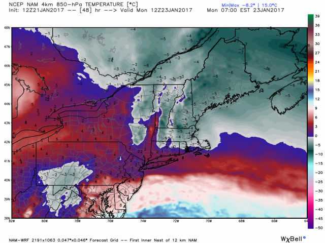
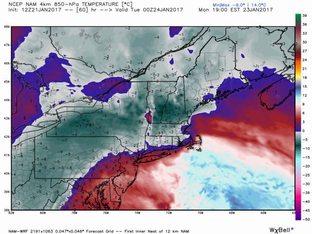
Check out these 850's temps - this would be an absolute paste job for Northern and western peeps and sleet as well
Get your generators ready and follow the hi res models and sr now forget the globals after seeing all teh deep convection and torm popping up in teh south they don't handle these types of storms well
Mugsy, NWS not buying JB's analysis at all, just pure rain up by me for the whole event.
Doc here is JB's thinking on why: Its actually quite an interesting read.
The tornadoes and severe weather in Mississippi are a sign that a front running impulse is coming out. That impulse is going to carve the path for this low to move along. The Euro wants it over Chesapeake bay for instance, and then the primary goes toward it. I think its likely to be off the Delmarva by tomorrow night, and that is where the big low winds up on Monday. Now consider this. Its so warm it cant get any warmer. What do I mean by that? Well all the warm air for the system is already on the playing field. Because winds are mainly west in the southern sector of the storm, there is no transport of warmer air into the center as it moves east. Instead the cooler air cmes flying in underneath and as the center moves further northeast, it starts drawing cooling are into it from the northeast . The front running system causing those tornadoes is HUGE in this for this should get off the mid atlantic coast tomorrow and when it does, establish the path for the primary center, after it moves up into WVA, to move along.
Look at the GFS 1 pm Monday
The warm air that is around now has gone into developing the storm as heights fall over it, but there is no warm inflow. The air mass to the northeast is low level cold air, Its why the new HIRES NAM is cooling this so dramatically, its seeing all this.
Hr 48
54
60
I think it has too much snow from NYC to BOS at this time
and too little back in central Pa simply because of the ideas I have analogged this too ( 3 storms that were warm that turned into big interior snows as centers drew cold air in, and precip processes cooled the air, late March 1984, Dec 1992, late March 1984). The warm advection leads to strong upward motion. Saturated air that may be 38 degrees at NYC is lifted and that can cool quite a bit, Meanwhile he sounding turns Isothermal and a bunch of people start turning over to snow west of the track to the upper low. as soon as the warm advectiion cuts off, which should be Monday as all the cooling gets around it, a bunch of people start turning over to snow That is the key. So what I do is figure out all the scenarios I see and weight them. Lets look here at State College. If I blend my 3 analogs it comes out to a foot. But suppose I look at modeling, take the average of the Canadian UKMET US models, ensembles and operational. I may have 10 samples I am looking at Now we got 15 with March 84 and Dec 1992 and 9 with the early 93 March storm. That is 39 for a total . the contribution from 7 models is only 7 So lets say there are 7 objective inputs adding up to 7 inches ( 1 each) and then my 3 analogs which tack on another 39 ( 15,15,9) . This gives me 10 tools totaling 46, which is an average of 4.6, hence the forecast of 3-6 put out a couple of days ago. NYC I said 1-3. This is not to get into a fight over either place Its to demonstrate a forecast method where you dont simply go into depression/elation cycles over model. I am trying to teach this to Garrett He flipped out yesterday at the 12z runs cause they were so warm ( I feel his pain, there has not been one major storm that has bullseyed state College since March 1994. We have gotten heavy snows, even had the most in some big storms, but the monsters have all been southeast of us with their maxes since he came into the world. And with the winter being lousy so far, as a snow geek he is upset. I grew up in ACY so any snow I saw when I got here was a dream come true, though we did get lollipopped a few times when I was a kid. and we all know the perverse satisfaction of knowing you had more snow than anyone else) . The time to flip out is Tuesday morning if there is nothing on the ground , not over models. But if you can come up with storm typing, then as the storm gets closer, you can eliminate the options. It may come down to the the biggest options are going to carry the day, it may come down to the opposite, 0 But if you have come up with a balanced figure then you dont worry about it, till you make the final change The storm 2 weekends ago was me trying to show this, The GFS started with nothing. We knew certain paths would yield certain results, so come up with the blend, then dont change it until you are certain of the one option that
Forecasting is not putting out 10 different options before an event. If you change your forecast 9 times, then out of 10 samples you were wrong on 90% of them. And whats more you cant go back and claim a foreacst was right. You can say, that idea was better, but I pulled it off the table. For instance in both December and now January, the ideas issued first beat the idea issued last ( right before the month) but the one that gets scored is the last one out, not the other one. In fact, I have violated my own methodology in some cases reacting to cold that came stronger quicker, but backed away BUT I ABSOLUTELY LOVE THE IDEA of people debating and making forecasts, but I think you cant run to the one that was right. So you try to stick with the product of your work. You will find that the more you put into something to come up with the answer, the better the chance you have of hitting it, and sticking with it, because you have studied the set up so closely,you are ready to pounce on the one that is best once you see it. But its the sum of the picture, and only when sure, do you jump on one aspect. In the winter so far, like the past several winters, it seems the EPO has been the king of the road and the SOI gyrations have been tipping that off around 10 days out. everything then responds to that.
I really think the answer to the forecast questions is not the models, but identifying EVERYTHING you can and then weighting it. The models are simply doing that. Their variance shows that obviously they disagree. So what is needed for the right answer. YOU! I dont care if you dont have a degree or not, if you love the weather and you love getting out there then you should put out your ideas. This is another libertarian rant against those that think its "irresponsible" for untrained guys to be posting forecasts. That is arrogant. I am suggesting a method that I use that you might want to try, sharing what I do. I am also suggesting that there is a philosophy that can make it easier not to swing all over the place when models do or do not go your way


Thank you Doc, for taking the time to post this.I understood a good part of it and I hope there is a chance it does play out for the area.I guess it's gonna be pretty much a nowcast thing soon but in the past, I have seen storms start as rain and gradually change over to snow and drop a large amount.Here's hoping!!!

docstox12- Wx Statistician Guru

- Posts : 8502
Reputation : 222
Join date : 2013-01-07
Age : 73
Location : Monroe NY
Re: January 22nd-24th Nor'easter Observations & Discussions
![]() by CPcantmeasuresnow Sat Jan 21, 2017 9:51 pm
by CPcantmeasuresnow Sat Jan 21, 2017 9:51 pm
jmanley32 wrote:I fully expect those numbers to go up in the morning briefing they are planning, NAM is coming in very intense with 925mb winds even reaching 75+ knots sustained. And lookie here, maybe its sleet but wow.Joe Snow wrote:And here is the NWS Briefing:
http://www.weather.gov/media/okx/Briefings/CoastalStormBriefing.pdf
2 NAM Runs in a row of over an inch of frozen precip in the HV. As you say most of this may be sleet, even some freezing rain but if this verifies, and the NAM is an outlier so far although I personally think it's leading the way here, this is going to make matters much more serious in those areas. Getting anxious to see what the short range models do with this now, I'd discount the next GFS, CMC, Euro and the lot at this point.
Last edited by CPcantmeasuresnow on Sat Jan 21, 2017 9:52 pm; edited 1 time in total

CPcantmeasuresnow- Wx Statistician Guru
- Posts : 7274
Reputation : 230
Join date : 2013-01-07
Age : 103
Location : Eastern Orange County, NY
Re: January 22nd-24th Nor'easter Observations & Discussions
![]() by Dunnzoo Sat Jan 21, 2017 9:51 pm
by Dunnzoo Sat Jan 21, 2017 9:51 pm
Teterboro hasn't changed, rain, with snow from 1-4am Tuesday
Albany, sleet starts earlier, 1 pm Monday until 1 am Tuesday
Caldwell went from sleet to snow, but starting later, 1 am -7am Tuesday
White Plains - snow starts earlier, 4 am Tuesday til about 9 am
So, NNJ and White Plains only rain an snow, Albany a lot of sleet. I am sure there will be mixing of all precip types at some point everywhere.
_________________
Janet
Snowfall winter of 2023-2024 17.5"
Snowfall winter of 2022-2023 6.0"
Snowfall winter of 2021-2022 17.6" 1" sleet 2/25/22
Snowfall winter of 2020-2021 51.1"
Snowfall winter of 2019-2020 8.5"
Snowfall winter of 2018-2019 25.1"
Snowfall winter of 2017-2018 51.9"
Snowfall winter of 2016-2017 45.6"
Snowfall winter of 2015-2016 29.5"
Snowfall winter of 2014-2015 50.55"
Snowfall winter of 2013-2014 66.5"

Dunnzoo- Senior Enthusiast - Mod
- Posts : 4886
Reputation : 68
Join date : 2013-01-11
Age : 62
Location : Westwood, NJ
Re: January 22nd-24th Nor'easter Observations & Discussions
![]() by algae888 Sat Jan 21, 2017 9:55 pm
by algae888 Sat Jan 21, 2017 9:55 pm
I find those soundings odd janet as the model shows snow/ sleet at the onset then rain later on. if you look at the tt maps it has some form of frozen precip from 15z Monday until 00z tues {acc map}then mainly rain.Dunnzoo wrote:Update on the 0z NAM soundings:
Teterboro hasn't changed, rain, with snow from 1-4am Tuesday
Albany, sleet starts earlier, 1 pm Monday until 1 am Tuesday
Caldwell went from sleet to snow, but starting later, 1 am -7am Tuesday
White Plains - snow starts earlier, 4 am Tuesday til about 9 am
So, NNJ and White Plains only rain an snow, Albany a lot of sleet. I am sure there will be mixing of all precip types at some point everywhere.

algae888- Advanced Forecaster

- Posts : 5311
Reputation : 46
Join date : 2013-02-05
Age : 61
Location : mt. vernon, new york
Re: January 22nd-24th Nor'easter Observations & Discussions
![]() by algae888 Sat Jan 21, 2017 9:57 pm
by algae888 Sat Jan 21, 2017 9:57 pm
algae888- Advanced Forecaster
- Posts : 5311
Reputation : 46
Join date : 2013-02-05
Age : 61
Location : mt. vernon, new york
Re: January 22nd-24th Nor'easter Observations & Discussions
![]() by jmanley32 Sat Jan 21, 2017 9:58 pm
by jmanley32 Sat Jan 21, 2017 9:58 pm
jmanley32- Senior Enthusiast
- Posts : 20513
Reputation : 108
Join date : 2013-12-12
Age : 42
Location : Yonkers, NY
Re: January 22nd-24th Nor'easter Observations & Discussions
![]() by jmanley32 Sat Jan 21, 2017 9:59 pm
by jmanley32 Sat Jan 21, 2017 9:59 pm
algae888 wrote:I find those soundings odd janet as the model shows snow/ sleet at the onset then rain later on. if you look at the tt maps it has some form of frozen precip from 15z Monday until 00z tues {acc map}then mainly rain.Dunnzoo wrote:Update on the 0z NAM soundings:
Teterboro hasn't changed, rain, with snow from 1-4am Tuesday
Albany, sleet starts earlier, 1 pm Monday until 1 am Tuesday
Caldwell went from sleet to snow, but starting later, 1 am -7am Tuesday
White Plains - snow starts earlier, 4 am Tuesday til about 9 am
So, NNJ and White Plains only rain an snow, Albany a lot of sleet. I am sure there will be mixing of all precip types at some point everywhere.
Tuesday> The precip is mainly monday no?
jmanley32- Senior Enthusiast
- Posts : 20513
Reputation : 108
Join date : 2013-12-12
Age : 42
Location : Yonkers, NY
Re: January 22nd-24th Nor'easter Observations & Discussions
![]() by Dunnzoo Sat Jan 21, 2017 10:00 pm
by Dunnzoo Sat Jan 21, 2017 10:00 pm
algae888 wrote:I find those soundings odd janet as the model shows snow/ sleet at the onset then rain later on. if you look at the tt maps it has some form of frozen precip from 15z Monday until 00z tues {acc map}then mainly rain.Dunnzoo wrote:Update on the 0z NAM soundings:
Teterboro hasn't changed, rain, with snow from 1-4am Tuesday
Albany, sleet starts earlier, 1 pm Monday until 1 am Tuesday
Caldwell went from sleet to snow, but starting later, 1 am -7am Tuesday
White Plains - snow starts earlier, 4 am Tuesday til about 9 am
So, NNJ and White Plains only rain an snow, Albany a lot of sleet. I am sure there will be mixing of all precip types at some point everywhere.
That's why I was looking at soundings, something didn't seem right to me with those snow/sleet maps. There seems to be an almost consistent warm nose at about 850mb so I wasn't convinced of any frozen precip making it through that layer...
_________________
Janet
Snowfall winter of 2023-2024 17.5"
Snowfall winter of 2022-2023 6.0"
Snowfall winter of 2021-2022 17.6" 1" sleet 2/25/22
Snowfall winter of 2020-2021 51.1"
Snowfall winter of 2019-2020 8.5"
Snowfall winter of 2018-2019 25.1"
Snowfall winter of 2017-2018 51.9"
Snowfall winter of 2016-2017 45.6"
Snowfall winter of 2015-2016 29.5"
Snowfall winter of 2014-2015 50.55"
Snowfall winter of 2013-2014 66.5"
Dunnzoo- Senior Enthusiast - Mod
- Posts : 4886
Reputation : 68
Join date : 2013-01-11
Age : 62
Location : Westwood, NJ
Re: January 22nd-24th Nor'easter Observations & Discussions
![]() by Dunnzoo Sat Jan 21, 2017 10:01 pm
by Dunnzoo Sat Jan 21, 2017 10:01 pm
jmanley32 wrote:algae888 wrote:I find those soundings odd janet as the model shows snow/ sleet at the onset then rain later on. if you look at the tt maps it has some form of frozen precip from 15z Monday until 00z tues {acc map}then mainly rain.Dunnzoo wrote:Update on the 0z NAM soundings:
Teterboro hasn't changed, rain, with snow from 1-4am Tuesday
Albany, sleet starts earlier, 1 pm Monday until 1 am Tuesday
Caldwell went from sleet to snow, but starting later, 1 am -7am Tuesday
White Plains - snow starts earlier, 4 am Tuesday til about 9 am
So, NNJ and White Plains only rain an snow, Albany a lot of sleet. I am sure there will be mixing of all precip types at some point everywhere.
Tuesday> The precip is mainly monday no?
Jman, from the soundings, it is all rain until late Monday night or early Tuesday and then turns over to frozen precip
_________________
Janet
Snowfall winter of 2023-2024 17.5"
Snowfall winter of 2022-2023 6.0"
Snowfall winter of 2021-2022 17.6" 1" sleet 2/25/22
Snowfall winter of 2020-2021 51.1"
Snowfall winter of 2019-2020 8.5"
Snowfall winter of 2018-2019 25.1"
Snowfall winter of 2017-2018 51.9"
Snowfall winter of 2016-2017 45.6"
Snowfall winter of 2015-2016 29.5"
Snowfall winter of 2014-2015 50.55"
Snowfall winter of 2013-2014 66.5"
Dunnzoo- Senior Enthusiast - Mod
- Posts : 4886
Reputation : 68
Join date : 2013-01-11
Age : 62
Location : Westwood, NJ
Re: January 22nd-24th Nor'easter Observations & Discussions
![]() by jmanley32 Sat Jan 21, 2017 10:01 pm
by jmanley32 Sat Jan 21, 2017 10:01 pm
jmanley32- Senior Enthusiast
- Posts : 20513
Reputation : 108
Join date : 2013-12-12
Age : 42
Location : Yonkers, NY
Re: January 22nd-24th Nor'easter Observations & Discussions
![]() by jmanley32 Sat Jan 21, 2017 10:03 pm
by jmanley32 Sat Jan 21, 2017 10:03 pm
jmanley32- Senior Enthusiast
- Posts : 20513
Reputation : 108
Join date : 2013-12-12
Age : 42
Location : Yonkers, NY
Re: January 22nd-24th Nor'easter Observations & Discussions
![]() by jmanley32 Sat Jan 21, 2017 10:06 pm
by jmanley32 Sat Jan 21, 2017 10:06 pm
jmanley32- Senior Enthusiast
- Posts : 20513
Reputation : 108
Join date : 2013-12-12
Age : 42
Location : Yonkers, NY
Re: January 22nd-24th Nor'easter Observations & Discussions
![]() by Dunnzoo Sat Jan 21, 2017 10:09 pm
by Dunnzoo Sat Jan 21, 2017 10:09 pm
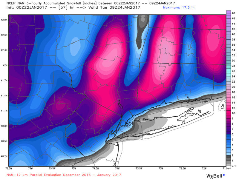
http://www.pivotalweather.com/model.php?m=nam&p=sfcwind_mslp&rh=2017012200&fh=-6&r=conus&dpdt=
_________________
Janet
Snowfall winter of 2023-2024 17.5"
Snowfall winter of 2022-2023 6.0"
Snowfall winter of 2021-2022 17.6" 1" sleet 2/25/22
Snowfall winter of 2020-2021 51.1"
Snowfall winter of 2019-2020 8.5"
Snowfall winter of 2018-2019 25.1"
Snowfall winter of 2017-2018 51.9"
Snowfall winter of 2016-2017 45.6"
Snowfall winter of 2015-2016 29.5"
Snowfall winter of 2014-2015 50.55"
Snowfall winter of 2013-2014 66.5"
Dunnzoo- Senior Enthusiast - Mod
- Posts : 4886
Reputation : 68
Join date : 2013-01-11
Age : 62
Location : Westwood, NJ
Page 4 of 43 • 1, 2, 3, 4, 5 ... 23 ... 43 ![]()
|
|
|