
 Search
Possible Snowstorm December 8th-9th
Page 3 of 15 •  1, 2, 3, 4 ... 9 ... 15
 ![]()
Re: Possible Snowstorm December 8th-9th
![]() by rb924119 Tue Dec 05, 2017 10:33 am
by rb924119 Tue Dec 05, 2017 10:33 am
crippo84 wrote:rb924119 wrote:MY GOD HERE COMES THE NAM
Please...do share the news lol.
Take a look at the below two images both valid 00Z Saturday:
GFS:
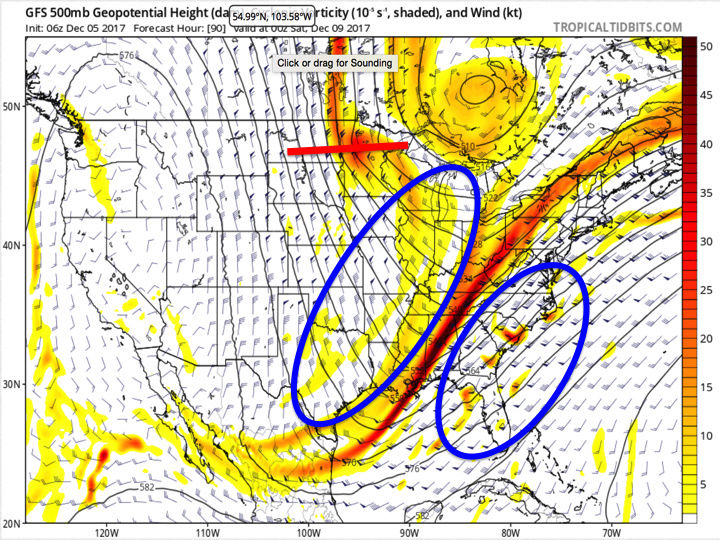
The northern stream energy diving down the southwestern flank of the mid-tropospheric PV is denoted by the red line through Minnesota. Note the extremely positive orientation of it compared to the much less positively tilted axis of the longer-wave trough centered through the eastern U.S., as well as the large amount of distance between the two. Also note the two blue ovals on either side of the larger-scale trough - they are there to highlight the wind barbs and forecasted strength/direction of the winds at this level. Notice how none of the barbs in the western oval are above 50 knots, while in the eastern one there are several well over 100 knots.
Compare that with the most recent NAM run valid for the same time:
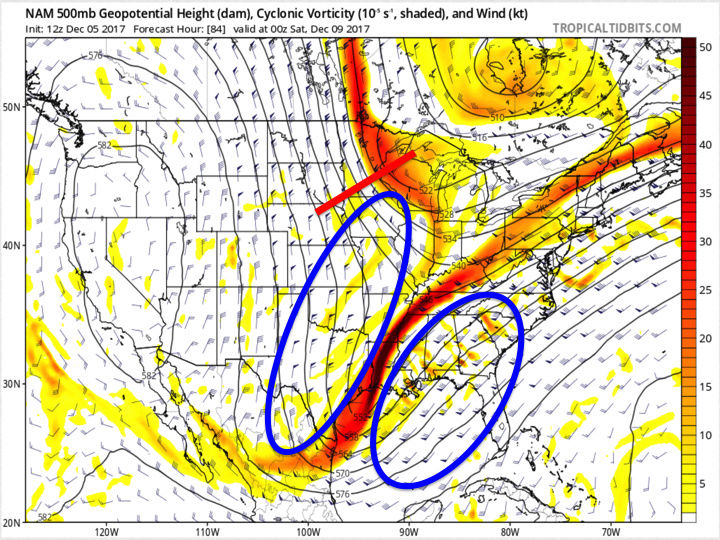
Notice the significant differences in the northern stream energy with respect to both strength, location, and orientation. Also note the differences in the strength and orientation of the forecasted winds ahead of and behind the larger-scale trough. The reason why the GFS is so strung out is because the northern stream energy has no way of catching up to the energy in the larger trough. Why? The winds out ahead of it slow down markedly while the winds ahead of the larger trough are significantly faster, thus "dragging" the energy in the main trough out so fast that it can't organize at all. The NAM, however, does NOT decelerate the winds ahead of the northern stream nearly as much which would allow it to progress much more quickly around the base of the PV. It's orientation is also very important because the closer the two trough axes are in alignment, the closer to a phase they are. Secondly, because the winds ahead of the northern stream energy/behind the main trough are not decelerating nearly as much AND they are also directed from due north to south, or even slightly north-northeast to south-southwest in conjunction with the winds being noticeably slower ahead of the main trough compared to the GFS, this allows the energy in the main trough to continue to dig further south AND consolidate some. Why does this matter? It will slow the main energy down and allow the northern stream energy to begin to really close the gap. It will also the heights ahead of the whole system to begin rising more than the GFS, which would direct the steering flow toward a more south to north direction instead of a west-southwest direction.
Unfortunately I don't time to go much further, but hopefully that makes sense.
rb924119- Meteorologist

- Posts : 6889
Join date : 2013-02-06
jake732- Pro Enthusiast

- Posts : 449
Join date : 2016-01-03 -

Re: Possible Snowstorm December 8th-9th
![]() by hyde345 Tue Dec 05, 2017 11:06 am
by hyde345 Tue Dec 05, 2017 11:06 am
rb924119 wrote:skinsfan1177 wrote:I still have hope in this system. We are days away anything can change. Hoping for positive trends today
I am NOT giving up hope on this system AT ALL. I feel strongly that we, or at least some of us, will end up seeing an accumulating snowfall from this system. As you stated below, the northern stream energy will not be well-sampled until late-week, and if my memory serves me correctly, modeling tends to significantly under-represent the strength and speed of energy in setups where the PV is displaced so far south and the energy is truly coming directly from the Arctic. I could be wrong, but pattern recognition argues for an East Coast storm, and with guidance a mere 50 miles too far east right now, I see no reason to abandon my ship.....yet lol
You might want to prepare the lifeboat if 12Z GFS is accurate.

hyde345- Pro Enthusiast
- Posts : 1082
Reputation : 48
Join date : 2013-01-08
Location : Hyde Park, NY
Re: Possible Snowstorm December 8th-9th
![]() by jake732 Tue Dec 05, 2017 11:08 am
by jake732 Tue Dec 05, 2017 11:08 am

jake732- Pro Enthusiast
- Posts : 449
Reputation : 0
Join date : 2016-01-03
Location : lakewood, nj -
Re: Possible Snowstorm December 8th-9th
![]() by sroc4 Tue Dec 05, 2017 11:13 am
by sroc4 Tue Dec 05, 2017 11:13 am
MattyICE wrote:Thanks, Frank. I have a question, for you, or anyone else. Completely understand that we have energy that is strung out and there's not enough consolidation or wave spacing. Is there any sort of teleconnection or other indicator that we should keep an eye on that sort of predicts WHEN energy consolidates itself better? I suspect the answer is no, and that it can happen organically as the pattern settles? No rush...thanks!
My answer to this question would be that you have to cont to watch all the teleconnections but interpret them with a grain of salt always. In theory we have some great teles on our side now, but even though high lat blocking lines up we still need the ingredients to come together in the right way. That said I think to actually answer your question in the current set up over the next 2-3weeks the NAO would be the tele to watch. With a -NAO combined with all the other teles that look to remain persistently favorable (-EPO/-AO/+PNA) that would increase the probabilities of the energy in the N branch and S branch from coming together better and more frequently.
Right now the latest trends have been to see heights lowering in the NAO region, (N Atlantic and Greenland) aka a +NAO) . "Usually" a negative NAO, esp west based(extending into Greenland), slows down the flow such that it is much easier for a digging s/w into the central CONUS out of canada to phase with any energy in the STJ tilting the trough neg along the EC leading to better/deeper cyclogenesis nearer the coast. The question before us now is does the flow off the EC remain too progressive due to the NAO region going neutral to positive, in which case the timing of the N and S energy needs to be just right. With a neg NAO it slows the flow down off the coast such that S energy moves west to east much slower, drags its heals if you will, giving more time for the N energy to catch up and interact. In the flow is too progressive off the coast then the S energy moves faster , so if the N energy isn't there in the right spot to capture/phase with it at that moment....poof its gone and you get weak waves of LP and strung out precip shields like we have been seeing in the modeling.
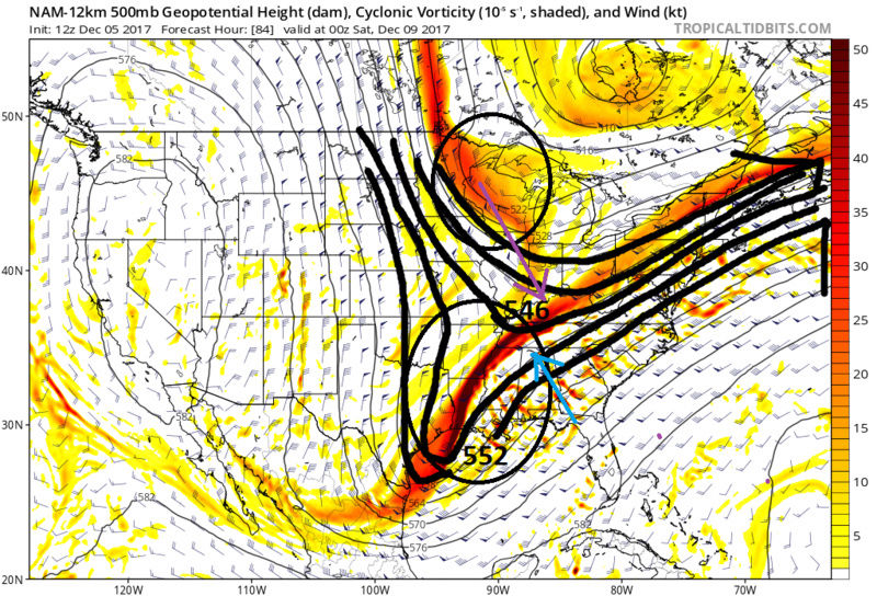
NAO is currently negative but going to go positive. Historically some of the best storms occur during such a transition. Skins made a great point above...sampling of some of the key players wont be great until at least wed-Thursday eve so still time for trends for better OR worse. NAM was very different in the handing of the N and S energy compared to the GFS and Euro
Look at the difference in how consolidated and the positioning of the N and s eNERGY, AND PAY PARTICULAR ATTENTION TO THE 546 LINE AND 552 LINE. (Sorry for the caps) Notice how the NAM is raising heights out ahead of the S energy. This indicates a slower mean flow in the STJ. Notice just how far S the 552 line is on the NAM. This is because the energy is more focused in the base of the trough here which again aids in raising heights out ahead. Also notice the N energy is further S digging in and and about to interact with the S branch. Verbatim if this run were to cont this would likely show a MUCH stronger surface LP compared to the GFS when it reaches the coastline. Vs the GFS which has both S and N branches as one full lat positively tilted trough that has an extremely progressive flow off the coast; therefore, the S energy is all strung out which doesn't allow heights to raise out in front. Fast flow. The GFS is known for its progressive bias but I wouldn't discount it at this stage. Bottom line most likely the coast has the best chance at seeing something measurable with decreasing odds the further away from the I-95 coastal plain you go with this system unless we see trends in the GFS/Euro closer to what the NAM showed today. IMO the fast flow off the coast will win out, so right now my bet is against anything significant for most if not all, but until wed-Thursday it aint ova.

_________________
"In weather and in life, there's no winning and losing; there's only winning and learning."
WINTER 2012/2013 TOTALS 43.65"WINTER 2017/2018 TOTALS 62.85" WINTER 2022/2023 TOTALS 4.9"
WINTER 2013/2014 TOTALS 64.85"WINTER 2018/2019 TOTALS 14.25" WINTER 2023/2024 TOTALS 13.1"
WINTER 2014/2015 TOTALS 71.20"WINTER 2019/2020 TOTALS 6.35"
WINTER 2015/2016 TOTALS 35.00"WINTER 2020/2021 TOTALS 37.75"
WINTER 2016/2017 TOTALS 42.25"WINTER 2021/2022 TOTALS 31.65"

sroc4- Admin

- Posts : 8331
Reputation : 301
Join date : 2013-01-07
Location : Wading River, LI
Re: Possible Snowstorm December 8th-9th
![]() by hyde345 Tue Dec 05, 2017 11:35 am
by hyde345 Tue Dec 05, 2017 11:35 am
hyde345- Pro Enthusiast
- Posts : 1082
Reputation : 48
Join date : 2013-01-08
Location : Hyde Park, NY
Re: Possible Snowstorm December 8th-9th
![]() by amugs Tue Dec 05, 2017 12:07 pm
by amugs Tue Dec 05, 2017 12:07 pm
I am not totally discounting the GFS but neither am I the NAM but the GEFS are a bit further west in some members so that to me gives caution for this and the energy is not a good sampling area until Thursday afternoon/night so it wont be fully digested into models until this time IMO.
The jet streak structure is so different .
Time will tell.
If this front gets to far east then we wave to these two storms
_________________
Mugs
AKA:King: Snow Weenie
Self Proclaimed
WINTER 2014-15 : 55.12" +.02 for 6 coatings (avg. 35")
WINTER 2015-16 Total - 29.8" (Avg 35")
WINTER 2016-17 : 39.5" so far

amugs- Advanced Forecaster - Mod

- Posts : 15093
Reputation : 213
Join date : 2013-01-07
Age : 54
Location : Hillsdale,NJ
Re: Possible Snowstorm December 8th-9th
![]() by aiannone Tue Dec 05, 2017 12:20 pm
by aiannone Tue Dec 05, 2017 12:20 pm
_________________
-Alex Iannone-

aiannone- Senior Enthusiast - Mod
- Posts : 4813
Reputation : 92
Join date : 2013-01-07
Location : Saint James, LI (Northwest Suffolk Co.)
Re: Possible Snowstorm December 8th-9th
![]() by aiannone Tue Dec 05, 2017 12:30 pm
by aiannone Tue Dec 05, 2017 12:30 pm
_________________
-Alex Iannone-
aiannone- Senior Enthusiast - Mod
- Posts : 4813
Reputation : 92
Join date : 2013-01-07
Location : Saint James, LI (Northwest Suffolk Co.)
Re: Possible Snowstorm December 8th-9th
![]() by amugs Tue Dec 05, 2017 12:46 pm
by amugs Tue Dec 05, 2017 12:46 pm
This is what I meant in my above post

_________________
Mugs
AKA:King: Snow Weenie
Self Proclaimed
WINTER 2014-15 : 55.12" +.02 for 6 coatings (avg. 35")
WINTER 2015-16 Total - 29.8" (Avg 35")
WINTER 2016-17 : 39.5" so far
amugs- Advanced Forecaster - Mod
- Posts : 15093
Reputation : 213
Join date : 2013-01-07
Age : 54
Location : Hillsdale,NJ
Re: Possible Snowstorm December 8th-9th
![]() by aiannone Tue Dec 05, 2017 1:28 pm
by aiannone Tue Dec 05, 2017 1:28 pm
_________________
-Alex Iannone-
aiannone- Senior Enthusiast - Mod
- Posts : 4813
Reputation : 92
Join date : 2013-01-07
Location : Saint James, LI (Northwest Suffolk Co.)
Re: Possible Snowstorm December 8th-9th
![]() by amugs Tue Dec 05, 2017 2:32 pm
by amugs Tue Dec 05, 2017 2:32 pm


IF this is correct it has room to move east 50 miles? 35? 75? is anyone's guess but if you are a close follower to EC storms as has been said on so many occasions we have this back and forth where we start off West move way east then come back west then tick east so we shall see.
_________________
Mugs
AKA:King: Snow Weenie
Self Proclaimed
WINTER 2014-15 : 55.12" +.02 for 6 coatings (avg. 35")
WINTER 2015-16 Total - 29.8" (Avg 35")
WINTER 2016-17 : 39.5" so far
amugs- Advanced Forecaster - Mod
- Posts : 15093
Reputation : 213
Join date : 2013-01-07
Age : 54
Location : Hillsdale,NJ
Re: Possible Snowstorm December 8th-9th
![]() by Guest Tue Dec 05, 2017 2:32 pm
by Guest Tue Dec 05, 2017 2:32 pm
Guest- Guest
Re: Possible Snowstorm December 8th-9th
![]() by amugs Tue Dec 05, 2017 4:23 pm
by amugs Tue Dec 05, 2017 4:23 pm

_________________
Mugs
AKA:King: Snow Weenie
Self Proclaimed
WINTER 2014-15 : 55.12" +.02 for 6 coatings (avg. 35")
WINTER 2015-16 Total - 29.8" (Avg 35")
WINTER 2016-17 : 39.5" so far
amugs- Advanced Forecaster - Mod
- Posts : 15093
Reputation : 213
Join date : 2013-01-07
Age : 54
Location : Hillsdale,NJ
Re: Possible Snowstorm December 8th-9th
![]() by skinsfan1177 Tue Dec 05, 2017 4:28 pm
by skinsfan1177 Tue Dec 05, 2017 4:28 pm

skinsfan1177- Senior Enthusiast

- Posts : 4485
Reputation : 35
Join date : 2013-01-07
Age : 46
Location : Point Pleasant Boro
Re: Possible Snowstorm December 8th-9th
![]() by rb924119 Tue Dec 05, 2017 4:55 pm
by rb924119 Tue Dec 05, 2017 4:55 pm
amugs wrote:NAM jet struture. It is west which means IF correct this storm would come more west and the precipitation field would expand west as well
The NAM, if extrapolated, would likely be a MECS/Godzilla for the I-95 corridor IMHO. Just saying lol
rb924119- Meteorologist
- Posts : 6889
Reputation : 194
Join date : 2013-02-06
Age : 32
Location : Greentown, Pa
Re: Possible Snowstorm December 8th-9th
![]() by mikeypizano Tue Dec 05, 2017 5:01 pm
by mikeypizano Tue Dec 05, 2017 5:01 pm

December 5: The GFS 10:1 snowfall product is currently affected by a data bug at NCEP, usually beyond Day 5. The snow depth change product is unaffected.

mikeypizano- Pro Enthusiast
- Posts : 1118
Reputation : 66
Join date : 2017-01-05
Age : 35
Location : Wilkes-Barre/Scranton, PA
Re: Possible Snowstorm December 8th-9th
![]() by frank 638 Tue Dec 05, 2017 5:37 pm
by frank 638 Tue Dec 05, 2017 5:37 pm
frank 638- Senior Enthusiast
- Posts : 2824
Reputation : 37
Join date : 2016-01-01
Age : 40
Location : bronx ny
Re: Possible Snowstorm December 8th-9th
![]() by algae888 Tue Dec 05, 2017 5:58 pm
by algae888 Tue Dec 05, 2017 5:58 pm
"Thu into Fri look quiet, with a weak W-E oriented ridge extending
from the OH Valley to the Mid Atlantic states. Then a complicated
scenario shapes up for late week into the weekend, as an upper
trough amplifies to the west, with potential for phasing of multiple
branches of the upper jet stream as low pressure passes off to the
SE. A combo of the operational GFS/ECMWF (with support from the GEFS
mean) suggests the trough should amplify enough to bring the core of
an associated SW-NE oriented upper jet streak as far west as NYC,
with fairly good chances for some snow east of there across Long
Island and southern CT with H8 temps below 0C and H8-10 thicknesses
below 1290 m. Latest ECMWF shows the core of the upper jet a little
farther west, across northern NJ. So have forecast high chance PoP
from NYC eastward, with most precip in the form of snow as temps
drop close to wet-bulb temps AOB 0C with onset of precip.
All that said, global models often have a SE bias with low tracks in
this scenario, and it would only take a 50-60 mile westward shift to
bring more significant snowfall amounts to the coast, so this
scenario will have to be watched closely. Shortwaves dropping into
the western extent of the longer wave trough across the Mississippi
Valley may help determine the eventual outcome--since they are
dropping southward into the base of the trough, they would be more
likely to reinforce or amplify, rather than kick the offshore low
farther out to sea."

algae888- Advanced Forecaster

- Posts : 5311
Reputation : 46
Join date : 2013-02-05
Age : 61
Location : mt. vernon, new york
Re: Possible Snowstorm December 8th-9th
![]() by mikeypizano Tue Dec 05, 2017 6:02 pm
by mikeypizano Tue Dec 05, 2017 6:02 pm
frank 638 wrote:I hate to ask but what does that mean is that good news or bad news
Hopefully under done but probably over

mikeypizano- Pro Enthusiast
- Posts : 1118
Reputation : 66
Join date : 2017-01-05
Age : 35
Location : Wilkes-Barre/Scranton, PA
Re: Possible Snowstorm December 8th-9th
![]() by algae888 Tue Dec 05, 2017 6:13 pm
by algae888 Tue Dec 05, 2017 6:13 pm
18z gfs...

12z...

algae888- Advanced Forecaster
- Posts : 5311
Reputation : 46
Join date : 2013-02-05
Age : 61
Location : mt. vernon, new york
Re: Possible Snowstorm December 8th-9th
![]() by algae888 Tue Dec 05, 2017 6:25 pm
by algae888 Tue Dec 05, 2017 6:25 pm
18z

12z

algae888- Advanced Forecaster
- Posts : 5311
Reputation : 46
Join date : 2013-02-05
Age : 61
Location : mt. vernon, new york
Re: Possible Snowstorm December 8th-9th
![]() by track17 Tue Dec 05, 2017 7:26 pm
by track17 Tue Dec 05, 2017 7:26 pm
track17- Posts : 454
Reputation : 4
Join date : 2016-01-09
Re: Possible Snowstorm December 8th-9th
![]() by skinsfan1177 Tue Dec 05, 2017 8:24 pm
by skinsfan1177 Tue Dec 05, 2017 8:24 pm
 [/url
[/url
skinsfan1177- Senior Enthusiast
- Posts : 4485
Reputation : 35
Join date : 2013-01-07
Age : 46
Location : Point Pleasant Boro
Re: Possible Snowstorm December 8th-9th
![]() by track17 Tue Dec 05, 2017 8:27 pm
by track17 Tue Dec 05, 2017 8:27 pm
track17- Posts : 454
Reputation : 4
Join date : 2016-01-09
Re: Possible Snowstorm December 8th-9th
![]() by Snow88 Tue Dec 05, 2017 9:26 pm
by Snow88 Tue Dec 05, 2017 9:26 pm
aiannone wrote:Or let me ask another question, does anyone recommend purchasing stormvista?
I have stormvista and Truewx
Both are great and the models come out very fast

Snow88- Senior Enthusiast
- Posts : 2193
Reputation : 4
Join date : 2013-01-09
Age : 35
Location : Brooklyn, NY
Re: Possible Snowstorm December 8th-9th
![]() by mikeypizano Tue Dec 05, 2017 9:27 pm
by mikeypizano Tue Dec 05, 2017 9:27 pm
Snow88 wrote:aiannone wrote:Or let me ask another question, does anyone recommend purchasing stormvista?
I have stormvista and Truewx
Both are great and the models come out very fast
I work for the guy who does IT support for True Weather... Does that count?
mikeypizano- Pro Enthusiast
- Posts : 1118
Reputation : 66
Join date : 2017-01-05
Age : 35
Location : Wilkes-Barre/Scranton, PA
Page 3 of 15 • 1, 2, 3, 4 ... 9 ... 15 ![]()
|
|
|