
 Search
January 4th Snowstorm: 1st Call Snow Map
Page 6 of 18 •  1 ... 5, 6, 7 ... 12 ... 18
 ![]()
Re: January 4th Snowstorm: 1st Call Snow Map
![]() by weatherwatchermom Wed Jan 03, 2018 8:12 am
by weatherwatchermom Wed Jan 03, 2018 8:12 am
Sanchize06 wrote:weatherwatchermom wrote:In Hazlet same as you in blue but they upped total from 1-3 to 3-6 in last couple of hoursSanchize06 wrote:Mt Holly clearly unsure about me here in Monmouth county as everyone else has either been upgraded to a WSW or placed under a WWA. Still a watch for now
Yeah, ultimately I think they'll go to a Winter Storm Warning, but I don't blame them for perhaps wanting to see the 12z runs first. Cut offs are tricky with this storm and Monmouth county is a little more difficult as the criteria is 6" for a warning whereas Ocean and places south are I believe 4 or 5".

hey I will take what I get and be happy...just think its funny our little spot is in watch vs warning.
weatherwatchermom- Senior Enthusiast

- Posts : 3738
Join date : 2014-11-25
Re: January 4th Snowstorm: 1st Call Snow Map
![]() by Frank_Wx Wed Jan 03, 2018 8:12 am
by Frank_Wx Wed Jan 03, 2018 8:12 am


Frank_Wx- Godzilla Seeker

- Posts : 21305
Join date : 2013-01-05 -

Re: January 4th Snowstorm: 1st Call Snow Map
![]() by Frank_Wx Wed Jan 03, 2018 8:14 am
by Frank_Wx Wed Jan 03, 2018 8:14 am

_________________
_______________________________________________________________________________________________________
CLICK HERE to view NJ Strong Snowstorm Classifications

Frank_Wx- Godzilla Seeker
- Posts : 21305
Reputation : 328
Join date : 2013-01-05
Age : 31
Location : Jersey City, NJ -
Re: January 4th Snowstorm: 1st Call Snow Map
![]() by jmanley32 Wed Jan 03, 2018 8:15 am
by jmanley32 Wed Jan 03, 2018 8:15 am

jmanley32- Senior Enthusiast
- Posts : 20516
Reputation : 108
Join date : 2013-12-12
Age : 42
Location : Yonkers, NY
Re: January 4th Snowstorm: 1st Call Snow Map
![]() by jmanley32 Wed Jan 03, 2018 8:16 am
by jmanley32 Wed Jan 03, 2018 8:16 am
This is incredible, if NYC sees anywhere near the totals from NAM theres no preparation, this would be bad, very bad.Frank_Wx wrote:In my opinion current radar suggests the storm wants to ride the coast rather than re-develop well east off the coast
jmanley32- Senior Enthusiast
- Posts : 20516
Reputation : 108
Join date : 2013-12-12
Age : 42
Location : Yonkers, NY
Re: January 4th Snowstorm: 1st Call Snow Map
![]() by Frank_Wx Wed Jan 03, 2018 8:16 am
by Frank_Wx Wed Jan 03, 2018 8:16 am

_________________
_______________________________________________________________________________________________________
CLICK HERE to view NJ Strong Snowstorm Classifications
Frank_Wx- Godzilla Seeker
- Posts : 21305
Reputation : 328
Join date : 2013-01-05
Age : 31
Location : Jersey City, NJ -
Re: January 4th Snowstorm: 1st Call Snow Map
![]() by skinsfan1177 Wed Jan 03, 2018 8:17 am
by skinsfan1177 Wed Jan 03, 2018 8:17 am
Frank_Wx wrote:09z SREFS shifted west. Show a WNW lean and qpf increased
Big shift

skinsfan1177- Senior Enthusiast
- Posts : 4485
Reputation : 35
Join date : 2013-01-07
Age : 46
Location : Point Pleasant Boro
Re: January 4th Snowstorm: 1st Call Snow Map
![]() by weatherwatchermom Wed Jan 03, 2018 8:20 am
by weatherwatchermom Wed Jan 03, 2018 8:20 am

weatherwatchermom- Senior Enthusiast
- Posts : 3738
Reputation : 77
Join date : 2014-11-25
Age : 60
Location : Hazlet Township, NJ
Re: January 4th Snowstorm: 1st Call Snow Map
![]() by Quietace Wed Jan 03, 2018 8:22 am
by Quietace Wed Jan 03, 2018 8:22 am
We do not really have onshore flow anyway...we will not mix if that is the question.weatherwatchermom wrote:Hey I have a question about water temps...the water temp at Sandy Hook is currently 31.6, will that help us during this storm?

Quietace- Meteorologist - Mod

- Posts : 3687
Reputation : 33
Join date : 2013-01-07
Age : 27
Location : Point Pleasant, NJ
Re: January 4th Snowstorm: 1st Call Snow Map
![]() by NjWeatherGuy Wed Jan 03, 2018 8:24 am
by NjWeatherGuy Wed Jan 03, 2018 8:24 am
Frank_Wx wrote:In my opinion current radar suggests the storm wants to ride the coast rather than re-develop well east off the coast
http://www.spc.noaa.gov/exper/mesoanalysis/new/viewsector.php?sector=18
Meso analysis. There's a low off the west coast of Florida just 2mb weaker than the one off the east coast over the Bahamas. Was this modeled?
Edit: No it wasn't, by GFS/NAM or CMC. Hmmmm.
Double Edit: Now it's gone, insignificant I suppose.
Last edited by NjWeatherGuy on Wed Jan 03, 2018 8:27 am; edited 2 times in total

NjWeatherGuy- Advanced Forecaster

- Posts : 4100
Reputation : 28
Join date : 2013-01-06
Location : Belle Mead, NJ
Re: January 4th Snowstorm: 1st Call Snow Map
![]() by weatherwatchermom Wed Jan 03, 2018 8:24 am
by weatherwatchermom Wed Jan 03, 2018 8:24 am
Quietace wrote:We do not really have onshore flow anyway...we will not mix if that is the question.weatherwatchermom wrote:Hey I have a question about water temps...the water temp at Sandy Hook is currently 31.6, will that help us during this storm?
no I am not worried about that..I was wondering if would enhance the snow...
weatherwatchermom- Senior Enthusiast
- Posts : 3738
Reputation : 77
Join date : 2014-11-25
Age : 60
Location : Hazlet Township, NJ
Re: January 4th Snowstorm: 1st Call Snow Map
![]() by Frank_Wx Wed Jan 03, 2018 8:28 am
by Frank_Wx Wed Jan 03, 2018 8:28 am
https://www-03.ibm.com/press/us/en/pressrelease/49954.wss
Here is what it predicts for Thursday's storm:


_________________
_______________________________________________________________________________________________________
CLICK HERE to view NJ Strong Snowstorm Classifications
Frank_Wx- Godzilla Seeker
- Posts : 21305
Reputation : 328
Join date : 2013-01-05
Age : 31
Location : Jersey City, NJ -
Re: January 4th Snowstorm: 1st Call Snow Map
![]() by Quietace Wed Jan 03, 2018 8:31 am
by Quietace Wed Jan 03, 2018 8:31 am
That is based on the MPAS core developed by NCAR. It was the core that should have been chosen for the next gen GFS rather than the FV3. It is rather accurate especially with the BL/CP etc. schemes they are running on it. I heard they might downscale it as well to boast accuracy since it is lacking in that(my only complaint, as expected in 15km model).Frank_Wx wrote:Found this to be cool. IBM develop their own model. Deep Thunder.
https://www-03.ibm.com/press/us/en/pressrelease/49954.wss
Here is what it predicts for Thursday's storm:
Last edited by Quietace on Wed Jan 03, 2018 8:33 am; edited 1 time in total
Quietace- Meteorologist - Mod
- Posts : 3687
Reputation : 33
Join date : 2013-01-07
Age : 27
Location : Point Pleasant, NJ
Re: January 4th Snowstorm: 1st Call Snow Map
![]() by jmanley32 Wed Jan 03, 2018 8:31 am
by jmanley32 Wed Jan 03, 2018 8:31 am
jmanley32- Senior Enthusiast
- Posts : 20516
Reputation : 108
Join date : 2013-12-12
Age : 42
Location : Yonkers, NY
Re: January 4th Snowstorm: 1st Call Snow Map
![]() by amugs Wed Jan 03, 2018 8:32 am
by amugs Wed Jan 03, 2018 8:32 am

_________________
Mugs
AKA:King: Snow Weenie
Self Proclaimed
WINTER 2014-15 : 55.12" +.02 for 6 coatings (avg. 35")
WINTER 2015-16 Total - 29.8" (Avg 35")
WINTER 2016-17 : 39.5" so far

amugs- Advanced Forecaster - Mod

- Posts : 15093
Reputation : 213
Join date : 2013-01-07
Age : 54
Location : Hillsdale,NJ
Re: January 4th Snowstorm: 1st Call Snow Map
![]() by jmanley32 Wed Jan 03, 2018 8:33 am
by jmanley32 Wed Jan 03, 2018 8:33 am
7.9 nyc and 24 in CT without ratios man that would be a kick especially since I USED to live there LOL, 7.9 with ratios would be over a foot through so not bad at all after what was called last night.Quietace wrote:That is based on the MPAS core developed by NCAR. It was the core that should have been chosen for the next gen GFS rather than the FV3. It is rather accurate especially with the BL/CP etc. schemes they are running on it.Frank_Wx wrote:Found this to be cool. IBM develop their own model. Deep Thunder.
https://www-03.ibm.com/press/us/en/pressrelease/49954.wss
Here is what it predicts for Thursday's storm:
jmanley32- Senior Enthusiast
- Posts : 20516
Reputation : 108
Join date : 2013-12-12
Age : 42
Location : Yonkers, NY
Re: January 4th Snowstorm: 1st Call Snow Map
![]() by jmanley32 Wed Jan 03, 2018 8:34 am
by jmanley32 Wed Jan 03, 2018 8:34 am
True enough, I am crossing all parts I can for the 12z hi res runs : )amugs wrote:IF this Hi Res Model is correct then Watch out is all I can say - either we bust in a BDB way or in a NEMO way.
jmanley32- Senior Enthusiast
- Posts : 20516
Reputation : 108
Join date : 2013-12-12
Age : 42
Location : Yonkers, NY
Re: January 4th Snowstorm: 1st Call Snow Map
![]() by jmanley32 Wed Jan 03, 2018 8:40 am
by jmanley32 Wed Jan 03, 2018 8:40 am
jmanley32- Senior Enthusiast
- Posts : 20516
Reputation : 108
Join date : 2013-12-12
Age : 42
Location : Yonkers, NY
Re: January 4th Snowstorm: 1st Call Snow Map
![]() by Quietace Wed Jan 03, 2018 8:41 am
by Quietace Wed Jan 03, 2018 8:41 am
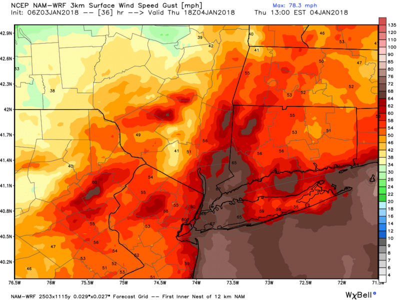
If thing develops as I think it will today, most people along the coast will go to BW's....jmanley32 wrote:Holy blitz and downright dangerous 3km!! Theres at least a 6 hr period that winds get over 65mph gusts even into NYC and westchester north, man oh man this would be epic with the snow it showed.
Quietace- Meteorologist - Mod
- Posts : 3687
Reputation : 33
Join date : 2013-01-07
Age : 27
Location : Point Pleasant, NJ
Re: January 4th Snowstorm: 1st Call Snow Map
![]() by Scullybutcher Wed Jan 03, 2018 8:42 am
by Scullybutcher Wed Jan 03, 2018 8:42 am
amugs wrote:IF this Hi Res Model is correct then Watch out is all I can say - either we bust in a BDB way or in a NEMO way.
I’ll take the Nemo bust all day long. Crippled Suffolk county for 3 days.

Scullybutcher- Pro Enthusiast

- Posts : 543
Reputation : 16
Join date : 2013-02-06
Location : North Smithtown, western Suffolk county, long island
Re: January 4th Snowstorm: 1st Call Snow Map
![]() by jmanley32 Wed Jan 03, 2018 8:44 am
by jmanley32 Wed Jan 03, 2018 8:44 am
winbds start kick up 50-60 gusts topping out as high as 75mph on LI and jersey around 8am and last most of the day, thats go cause a lot power issues. So you buy the nam runs? I am pretty close to the coast, looking forward to it, this is nuts!! I hope it pans out, if not I will try to live on lolQuietace wrote:If thing develops as I think it will today, most people along the coast will go to BW's....jmanley32 wrote:Holy blitz and downright dangerous 3km!! Theres at least a 6 hr period that winds get over 65mph gusts even into NYC and westchester north, man oh man this would be epic with the snow it showed.
jmanley32- Senior Enthusiast
- Posts : 20516
Reputation : 108
Join date : 2013-12-12
Age : 42
Location : Yonkers, NY
Re: January 4th Snowstorm: 1st Call Snow Map
![]() by Guest Wed Jan 03, 2018 8:46 am
by Guest Wed Jan 03, 2018 8:46 am
Frank_Wx wrote:In my opinion current radar suggests the storm wants to ride the coast rather than re-develop well east off the coast
Agreed Frank. Any chance you “ re-visit” your first call map before lunchtime? Maybe after the 12 z runs. Anyone have the HRRR. I thought it usually does a good job of showing the precip and radar inside of 24 hours.
Guest- Guest
Re: January 4th Snowstorm: 1st Call Snow Map
![]() by amugs Wed Jan 03, 2018 8:46 am
by amugs Wed Jan 03, 2018 8:46 am
This is awesome:
Operational models have already shifted about 50 miles closer
to LI with track of low pressure by late Thursday than 24 hrs
ago, with consensus track of a 955 to 960 mb low pressure
system tracking over or just se of the 40/70 lat/lon benchmark.
The exact phasing evolution will determine any additional
forecast track adjustment, with GEFS/ECMWF/SREF still showing at
least 150 miles of spread in members within 24-36 hrs. This
range of potential shift would have significant implication on
westward expanse of frontogenetically forced heavy snow banding,
and strong to damaging wind fields with this intense low. In
fact 06z NAM, has taken a significant shift westward from 00z
with its frontogenetic forcing, showing potential for 1 ft+ snow
across the entire area. For this reason, NHC will be doing a
reconnaissance flight and several dropsondes this
afternoon/evening off the Fl/SE US coast to better capture this
phasing and convection latent heat release in the models.
SREFS!!!!!!!!!!!!!!!!!!!!!!!!!
Need 12Z models to show the same or just a blip.
This storm so reminds me of the BDB and blizzard of 1983, 2016 where there was a meh for NYC and then within 12 hours of hitting things
_________________
Mugs
AKA:King: Snow Weenie
Self Proclaimed
WINTER 2014-15 : 55.12" +.02 for 6 coatings (avg. 35")
WINTER 2015-16 Total - 29.8" (Avg 35")
WINTER 2016-17 : 39.5" so far
amugs- Advanced Forecaster - Mod
- Posts : 15093
Reputation : 213
Join date : 2013-01-07
Age : 54
Location : Hillsdale,NJ
Re: January 4th Snowstorm: 1st Call Snow Map
![]() by CPcantmeasuresnow Wed Jan 03, 2018 8:53 am
by CPcantmeasuresnow Wed Jan 03, 2018 8:53 am
Frank_Wx wrote:09z SREFS shifted west. Show a WNW lean and qpf increased
Very significant. This is the first run of the srefs that has me in the .5 inch area, before this it was always .2-.3 at best. After the NAM bonanza this is another nice trend west. Cautious optimism still, storms that get this deep seem to have a mind of their own.

CPcantmeasuresnow- Wx Statistician Guru

- Posts : 7274
Reputation : 230
Join date : 2013-01-07
Age : 103
Location : Eastern Orange County, NY
Re: January 4th Snowstorm: 1st Call Snow Map
![]() by Frank_Wx Wed Jan 03, 2018 8:54 am
by Frank_Wx Wed Jan 03, 2018 8:54 am

_________________
_______________________________________________________________________________________________________
CLICK HERE to view NJ Strong Snowstorm Classifications
Frank_Wx- Godzilla Seeker
- Posts : 21305
Reputation : 328
Join date : 2013-01-05
Age : 31
Location : Jersey City, NJ -
Re: January 4th Snowstorm: 1st Call Snow Map
![]() by CPcantmeasuresnow Wed Jan 03, 2018 8:56 am
by CPcantmeasuresnow Wed Jan 03, 2018 8:56 am
Frank_Wx wrote:NAM coming in now. Already major differences with the southern s/w. So far looks weaker on the 12z NAM run compared to 06z.
Well that would be a kick in the ass, but not totally unexpected either.
CPcantmeasuresnow- Wx Statistician Guru
- Posts : 7274
Reputation : 230
Join date : 2013-01-07
Age : 103
Location : Eastern Orange County, NY
Re: January 4th Snowstorm: 1st Call Snow Map
![]() by Quietace Wed Jan 03, 2018 8:56 am
by Quietace Wed Jan 03, 2018 8:56 am
Quietace- Meteorologist - Mod
- Posts : 3687
Reputation : 33
Join date : 2013-01-07
Age : 27
Location : Point Pleasant, NJ
Page 6 of 18 • 1 ... 5, 6, 7 ... 12 ... 18 ![]()
|
|
|