
 Search
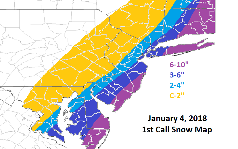
January 4th Snowstorm: 1st Call Snow Map
Page 13 of 18 •  1 ... 8 ... 12, 13, 14 ... 18
 ![]()
Re: January 4th Snowstorm: 1st Call Snow Map
![]() by algae888 Wed Jan 03, 2018 12:43 pm
by algae888 Wed Jan 03, 2018 12:43 pm
rb924119 wrote:algae888 wrote:also convection right now on radar is over land. not one model had that at 12z.
That's why they've been focusing on the wrong energy and have been so far east
every model today including ens. was west with the precip shield except the cmc and the nam which has flipped flopped the last few runs.
algae888- Advanced Forecaster

- Posts : 5311
Join date : 2013-02-05
Re: January 4th Snowstorm: 1st Call Snow Map
![]() by mmanisca Wed Jan 03, 2018 12:44 pm
by mmanisca Wed Jan 03, 2018 12:44 pm
mmanisca- Pro Enthusiast

- Posts : 298
Join date : 2013-01-23
Re: January 4th Snowstorm: 1st Call Snow Map
![]() by GreyBeard Wed Jan 03, 2018 12:46 pm
by GreyBeard Wed Jan 03, 2018 12:46 pm
essexcountypete wrote:Roger92 wrote:2.5 mm in one inch.Roger92 wrote:5-6" lolgigs68 wrote:Question-12-15 mm. How does that convert to inches of snow?
Pretty sure Frank meant 12-15 centimeters. I sure hope he did
That's what I was thinking Pete because 12-15 mm is about a 1/2"
Last edited by GreyBeard on Wed Jan 03, 2018 12:48 pm; edited 1 time in total
GreyBeard- Senior Enthusiast

- Posts : 725
Reputation : 34
Join date : 2014-02-12
Location : eastern nassau county
Re: January 4th Snowstorm: 1st Call Snow Map
![]() by rb924119 Wed Jan 03, 2018 12:48 pm
by rb924119 Wed Jan 03, 2018 12:48 pm
jimv45 wrote:Rb I know Frank will update his map. Are you coming out with a map today?
Unfortunately, no. I actually am taking a break from forecasting (on that level) this season. One reason is because I lost a subscription to my all-time favorite forecasting site, and the other is that I've been devoting pretty much all of my free time to my project so I can finally get it done. It's taken me well beyond the date I originally intended, so I'm trying to just buckle down and get it done so I can actually have a summer and get back to actually forecasting next winter season with a renewed subscription ahaha
rb924119- Meteorologist

- Posts : 6890
Reputation : 194
Join date : 2013-02-06
Age : 32
Location : Greentown, Pa
Re: January 4th Snowstorm: 1st Call Snow Map
![]() by Frank_Wx Wed Jan 03, 2018 12:52 pm
by Frank_Wx Wed Jan 03, 2018 12:52 pm
rb924119 wrote:jimv45 wrote:Rb I know Frank will update his map. Are you coming out with a map today?
Unfortunately, no. I actually am taking a break from forecasting (on that level) this season. One reason is because I lost a subscription to my all-time favorite forecasting site, and the other is that I've been devoting pretty much all of my free time to my project so I can finally get it done. It's taken me well beyond the date I originally intended, so I'm trying to just buckle down and get it done so I can actually have a summer and get back to actually forecasting next winter season with a renewed subscription ahaha
I saw your PM. Will get back to you today.
_________________
_______________________________________________________________________________________________________
CLICK HERE to view NJ Strong Snowstorm Classifications

Frank_Wx- Godzilla Seeker

- Posts : 21305
Reputation : 328
Join date : 2013-01-05
Age : 31
Location : Jersey City, NJ -

Re: January 4th Snowstorm: 1st Call Snow Map
![]() by Frank_Wx Wed Jan 03, 2018 12:54 pm
by Frank_Wx Wed Jan 03, 2018 12:54 pm


_________________
_______________________________________________________________________________________________________
CLICK HERE to view NJ Strong Snowstorm Classifications
Frank_Wx- Godzilla Seeker
- Posts : 21305
Reputation : 328
Join date : 2013-01-05
Age : 31
Location : Jersey City, NJ -
Re: January 4th Snowstorm: 1st Call Snow Map
![]() by Frank_Wx Wed Jan 03, 2018 12:57 pm
by Frank_Wx Wed Jan 03, 2018 12:57 pm
GreyBeard wrote:essexcountypete wrote:Roger92 wrote:2.5 mm in one inch.Roger92 wrote:5-6" lolgigs68 wrote:Question-12-15 mm. How does that convert to inches of snow?
Pretty sure Frank meant 12-15 centimeters. I sure hope he did
That's what I was thinking Pete because 12-15 mm is about a 1/2"Frank is trying to confuse us by going metric

12mm = about .50" qpf
.50" qpf is about 5 inches of snow
DO WE ALL UNDERSTAND NOW, CLASS!
_________________
_______________________________________________________________________________________________________
CLICK HERE to view NJ Strong Snowstorm Classifications
Frank_Wx- Godzilla Seeker
- Posts : 21305
Reputation : 328
Join date : 2013-01-05
Age : 31
Location : Jersey City, NJ -
Re: January 4th Snowstorm: 1st Call Snow Map
![]() by gigs68 Wed Jan 03, 2018 12:59 pm
by gigs68 Wed Jan 03, 2018 12:59 pm
Frank_Wx wrote:GreyBeard wrote:essexcountypete wrote:Roger92 wrote:2.5 mm in one inch.Roger92 wrote:5-6" lolgigs68 wrote:Question-12-15 mm. How does that convert to inches of snow?
Pretty sure Frank meant 12-15 centimeters. I sure hope he did
That's what I was thinking Pete because 12-15 mm is about a 1/2"
12mm = about .50" qpf
.50" qpf is about 5 inches of snow
DO WE ALL UNDERSTAND NOW, CLASS!
LOL Thanks Frank

gigs68- Posts : 142
Reputation : 3
Join date : 2013-01-16
Location : Commack, NY (NW Suffolk)
Re: January 4th Snowstorm: 1st Call Snow Map
![]() by Frank_Wx Wed Jan 03, 2018 1:00 pm
by Frank_Wx Wed Jan 03, 2018 1:00 pm
_________________
_______________________________________________________________________________________________________
CLICK HERE to view NJ Strong Snowstorm Classifications
Frank_Wx- Godzilla Seeker
- Posts : 21305
Reputation : 328
Join date : 2013-01-05
Age : 31
Location : Jersey City, NJ -
Re: January 4th Snowstorm: 1st Call Snow Map
![]() by Frank_Wx Wed Jan 03, 2018 1:00 pm
by Frank_Wx Wed Jan 03, 2018 1:00 pm

_________________
_______________________________________________________________________________________________________
CLICK HERE to view NJ Strong Snowstorm Classifications
Frank_Wx- Godzilla Seeker
- Posts : 21305
Reputation : 328
Join date : 2013-01-05
Age : 31
Location : Jersey City, NJ -
Re: January 4th Snowstorm: 1st Call Snow Map
![]() by SoulSingMG Wed Jan 03, 2018 1:01 pm
by SoulSingMG Wed Jan 03, 2018 1:01 pm
"Ya wanted it, ya got it.
Do we start to lift the cap off some totals? I "like" my pinned tweet from this AM but the system is quite wet, some models trending wetter, mentioned the 6-12" contour portion could come up. Maybe by 3-5pm period of evolve will allow prudent decision"

SoulSingMG- Senior Enthusiast
- Posts : 2853
Reputation : 74
Join date : 2013-12-11
Location : Long Island City, NY
Re: January 4th Snowstorm: 1st Call Snow Map
![]() by hyde345 Wed Jan 03, 2018 1:03 pm
by hyde345 Wed Jan 03, 2018 1:03 pm
Frank_Wx wrote:
That's not terrible and it's only thru 18Z

hyde345- Pro Enthusiast
- Posts : 1082
Reputation : 48
Join date : 2013-01-08
Location : Hyde Park, NY
Re: January 4th Snowstorm: 1st Call Snow Map
![]() by Frank_Wx Wed Jan 03, 2018 1:04 pm
by Frank_Wx Wed Jan 03, 2018 1:04 pm
NAM-0.7
Hi-res NAM-1.2
RGEM-0.40-0.45
HRDPS-0.60
CMC-0.30
GFS-0.40
UKMET- 0.55-0.6
EURO-0.40
SREFs-0.70
_________________
_______________________________________________________________________________________________________
CLICK HERE to view NJ Strong Snowstorm Classifications
Frank_Wx- Godzilla Seeker
- Posts : 21305
Reputation : 328
Join date : 2013-01-05
Age : 31
Location : Jersey City, NJ -
Re: January 4th Snowstorm: 1st Call Snow Map
![]() by GreyBeard Wed Jan 03, 2018 1:05 pm
by GreyBeard Wed Jan 03, 2018 1:05 pm
Frank_Wx wrote:GreyBeard wrote:essexcountypete wrote:Roger92 wrote:2.5 mm in one inch.Roger92 wrote:5-6" lolgigs68 wrote:Question-12-15 mm. How does that convert to inches of snow?
Pretty sure Frank meant 12-15 centimeters. I sure hope he did
That's what I was thinking Pete because 12-15 mm is about a 1/2"
12mm = about .50" qpf
.50" qpf is about 5 inches of snow
DO WE ALL UNDERSTAND NOW, CLASS!
THAT'S NOT WHAT YOU SAID TEACHER . YOU SAID 12-15 MM OF SNOW. DO YOU UNDERSTAND?
GreyBeard- Senior Enthusiast
- Posts : 725
Reputation : 34
Join date : 2014-02-12
Location : eastern nassau county
Re: January 4th Snowstorm: 1st Call Snow Map
![]() by Frank_Wx Wed Jan 03, 2018 1:06 pm
by Frank_Wx Wed Jan 03, 2018 1:06 pm
Frank_Wx wrote:
This will definitely be updated later today. Final call snow map will be issued between 10-10:30 tonight. At the moment, leaning on higher totals across the board and introducing a 10"+ zone.
_________________
_______________________________________________________________________________________________________
CLICK HERE to view NJ Strong Snowstorm Classifications
Frank_Wx- Godzilla Seeker
- Posts : 21305
Reputation : 328
Join date : 2013-01-05
Age : 31
Location : Jersey City, NJ -
Re: January 4th Snowstorm: 1st Call Snow Map
![]() by Guest Wed Jan 03, 2018 1:06 pm
by Guest Wed Jan 03, 2018 1:06 pm
Guest- Guest
Re: January 4th Snowstorm: 1st Call Snow Map
![]() by Frank_Wx Wed Jan 03, 2018 1:07 pm
by Frank_Wx Wed Jan 03, 2018 1:07 pm
GreyBeard wrote:Frank_Wx wrote:GreyBeard wrote:essexcountypete wrote:Roger92 wrote:2.5 mm in one inch.Roger92 wrote:5-6" lolgigs68 wrote:Question-12-15 mm. How does that convert to inches of snow?
Pretty sure Frank meant 12-15 centimeters. I sure hope he did
That's what I was thinking Pete because 12-15 mm is about a 1/2"
12mm = about .50" qpf
.50" qpf is about 5 inches of snow
DO WE ALL UNDERSTAND NOW, CLASS!
THAT'S NOT WHAT YOU SAID TEACHER . YOU SAID 12-15 MM OF SNOW. DO YOU UNDERSTAND?

_________________
_______________________________________________________________________________________________________
CLICK HERE to view NJ Strong Snowstorm Classifications
Frank_Wx- Godzilla Seeker
- Posts : 21305
Reputation : 328
Join date : 2013-01-05
Age : 31
Location : Jersey City, NJ -
Re: January 4th Snowstorm: 1st Call Snow Map
![]() by Guest Wed Jan 03, 2018 1:09 pm
by Guest Wed Jan 03, 2018 1:09 pm
Frank_Wx wrote:For NYC 12z guidance:
NAM-0.7
Hi-res NAM-1.2
RGEM-0.40-0.45
HRDPS-0.60
CMC-0.30
GFS-0.40
UKMET- 0.55-0.6
EURO-0.40
SREFs-0.70
.6” avg NYC equals 9” snow
Guest- Guest
Re: January 4th Snowstorm: 1st Call Snow Map
![]() by rb924119 Wed Jan 03, 2018 1:09 pm
by rb924119 Wed Jan 03, 2018 1:09 pm
Frank_Wx wrote:rb924119 wrote:jimv45 wrote:Rb I know Frank will update his map. Are you coming out with a map today?
Unfortunately, no. I actually am taking a break from forecasting (on that level) this season. One reason is because I lost a subscription to my all-time favorite forecasting site, and the other is that I've been devoting pretty much all of my free time to my project so I can finally get it done. It's taken me well beyond the date I originally intended, so I'm trying to just buckle down and get it done so I can actually have a summer and get back to actually forecasting next winter season with a renewed subscription ahaha
I saw your PM. Will get back to you today.
Ah!!! No worries, though, man, I figured that since you haven't been on here as much you've been busy with other things haha and if worse came to worst I'd just send you another one upon the completion of the project to request for next season aha......squeaky wheel gets the oil, you know

rb924119- Meteorologist
- Posts : 6890
Reputation : 194
Join date : 2013-02-06
Age : 32
Location : Greentown, Pa
Re: January 4th Snowstorm: 1st Call Snow Map
![]() by GreyBeard Wed Jan 03, 2018 1:10 pm
by GreyBeard Wed Jan 03, 2018 1:10 pm
 to Franks surrendering.
GreyBeard- Senior Enthusiast
- Posts : 725
Reputation : 34
Join date : 2014-02-12
Location : eastern nassau county
Re: January 4th Snowstorm: 1st Call Snow Map
![]() by SoulSingMG Wed Jan 03, 2018 1:15 pm
by SoulSingMG Wed Jan 03, 2018 1:15 pm
"It's already special and the 1-3pm uptick is quite noticable on imagery. But wait until we get to the 3-6pm period. The acceleration of rate of development will continue to increase dramatically this afternoon and evening. CONSTANT evolution chase to adjust forecasts today."
SoulSingMG- Senior Enthusiast
- Posts : 2853
Reputation : 74
Join date : 2013-12-11
Location : Long Island City, NY
Re: January 4th Snowstorm: 1st Call Snow Map
![]() by Frank_Wx Wed Jan 03, 2018 1:16 pm
by Frank_Wx Wed Jan 03, 2018 1:16 pm

_________________
_______________________________________________________________________________________________________
CLICK HERE to view NJ Strong Snowstorm Classifications
Frank_Wx- Godzilla Seeker
- Posts : 21305
Reputation : 328
Join date : 2013-01-05
Age : 31
Location : Jersey City, NJ -
Re: January 4th Snowstorm: 1st Call Snow Map
![]() by nutleyblizzard Wed Jan 03, 2018 1:17 pm
by nutleyblizzard Wed Jan 03, 2018 1:17 pm

nutleyblizzard- Senior Enthusiast
- Posts : 1952
Reputation : 41
Join date : 2014-01-30
Age : 58
Location : Nutley, new jersey
Re: January 4th Snowstorm: 1st Call Snow Map
![]() by Frank_Wx Wed Jan 03, 2018 1:17 pm
by Frank_Wx Wed Jan 03, 2018 1:17 pm

_________________
_______________________________________________________________________________________________________
CLICK HERE to view NJ Strong Snowstorm Classifications
Frank_Wx- Godzilla Seeker
- Posts : 21305
Reputation : 328
Join date : 2013-01-05
Age : 31
Location : Jersey City, NJ -
Re: January 4th Snowstorm: 1st Call Snow Map
![]() by Frank_Wx Wed Jan 03, 2018 1:18 pm
by Frank_Wx Wed Jan 03, 2018 1:18 pm

_________________
_______________________________________________________________________________________________________
CLICK HERE to view NJ Strong Snowstorm Classifications
Frank_Wx- Godzilla Seeker
- Posts : 21305
Reputation : 328
Join date : 2013-01-05
Age : 31
Location : Jersey City, NJ -
Re: January 4th Snowstorm: 1st Call Snow Map
![]() by Quietace Wed Jan 03, 2018 1:21 pm
by Quietace Wed Jan 03, 2018 1:21 pm

Quietace- Meteorologist - Mod

- Posts : 3687
Reputation : 33
Join date : 2013-01-07
Age : 27
Location : Point Pleasant, NJ
Re: January 4th Snowstorm: 1st Call Snow Map
![]() by nutleyblizzard Wed Jan 03, 2018 1:29 pm
by nutleyblizzard Wed Jan 03, 2018 1:29 pm
nutleyblizzard- Senior Enthusiast
- Posts : 1952
Reputation : 41
Join date : 2014-01-30
Age : 58
Location : Nutley, new jersey
Page 13 of 18 • 1 ... 8 ... 12, 13, 14 ... 18 ![]()
|
|
|