
 Search
2018 Hurricane Season
Page 7 of 18 •  1 ... 6, 7, 8 ... 12 ... 18
 ![]()
Re: 2018 Hurricane Season
![]() by Joe Snow Wed Sep 05, 2018 10:37 pm
by Joe Snow Wed Sep 05, 2018 10:37 pm
jmanley32 wrote:Oh boy, I know you listen to this guy, most of you all so heads up I guess.amugs wrote:Our own Armando Salvatore posted on another board and if he leaning then we watch
Just adding my "2cents" to the discussion from observations as of late. Typically, we tend to look upstream for winter in regards to tracking, so why not apply that methodology here.... The 18z GFS pretty much represents the consensus of NWP (have checked CMC, GEFS, EPS). Two main areas I've been watching; 1. British Canada and 2. Midwest (Gorden remnants/ S/W troff). Notice initially right at the beginning of the loop how the trough off BC begins closer to the 150W meridian, and towards the latter end of the loop ends up towards 120W. Also take note of the orientation of the trough axis, and how it goes from a meridional look to one that is more positively tilted yielding a semi-zonal flow . This has a downstream effect because whereas runs dating back to Sept 1st or so, we saw a more retrograded type look of the ridge further back west where you have a weak steering flow, and thanks to the Coriolis effect, Florence can find that weakness pocket. However, because of this noticeable trend (?), we're seeing a "push" of everything eastward, including diabetic processes from the remnants of Gordon embedded within a shortwave trough, that influences that anomalous ridge over the NW Atlantic. In turn, we thus see rather strong ageostrophic confluence (highlighted in yellow) on the backside of the long wave trough and it reflects an impressive ~1030-1034mb surface high that can ultimately traverse quickly enough to mitigate that weakness area and critical inflection point. What I suppose I'm trying to convey is that via synoptic pattern wise, the trends aren't good meaning this threat has "legs
J Man Gonna be some long days ahead tracking.....................
Joe Snow- Pro Enthusiast

- Posts : 924
Join date : 2014-02-12
Re: 2018 Hurricane Season
![]() by jmanley32 Wed Sep 05, 2018 10:44 pm
by jmanley32 Wed Sep 05, 2018 10:44 pm
for sure getting my rest now show starts or ends Sunday Monday I think. What have people been say on storm2k?Joe Snow wrote:jmanley32 wrote:Oh boy, I know you listen to this guy, most of you all so heads up I guess.amugs wrote:Our own Armando Salvatore posted on another board and if he leaning then we watch
Just adding my "2cents" to the discussion from observations as of late. Typically, we tend to look upstream for winter in regards to tracking, so why not apply that methodology here.... The 18z GFS pretty much represents the consensus of NWP (have checked CMC, GEFS, EPS). Two main areas I've been watching; 1. British Canada and 2. Midwest (Gorden remnants/ S/W troff). Notice initially right at the beginning of the loop how the trough off BC begins closer to the 150W meridian, and towards the latter end of the loop ends up towards 120W. Also take note of the orientation of the trough axis, and how it goes from a meridional look to one that is more positively tilted yielding a semi-zonal flow . This has a downstream effect because whereas runs dating back to Sept 1st or so, we saw a more retrograded type look of the ridge further back west where you have a weak steering flow, and thanks to the Coriolis effect, Florence can find that weakness pocket. However, because of this noticeable trend (?), we're seeing a "push" of everything eastward, including diabetic processes from the remnants of Gordon embedded within a shortwave trough, that influences that anomalous ridge over the NW Atlantic. In turn, we thus see rather strong ageostrophic confluence (highlighted in yellow) on the backside of the long wave trough and it reflects an impressive ~1030-1034mb surface high that can ultimately traverse quickly enough to mitigate that weakness area and critical inflection point. What I suppose I'm trying to convey is that via synoptic pattern wise, the trends aren't good meaning this threat has "legs
J Man Gonna be some long days ahead tracking.....................
jmanley32- Senior Enthusiast

- Posts : 20513
Join date : 2013-12-12
Re: 2018 Hurricane Season
![]() by Joe Snow Wed Sep 05, 2018 10:55 pm
by Joe Snow Wed Sep 05, 2018 10:55 pm
jmanley32 wrote:for sure getting my rest now show starts or ends Sunday Monday I think. What have people been say on storm2k?Joe Snow wrote:jmanley32 wrote:Oh boy, I know you listen to this guy, most of you all so heads up I guess.amugs wrote:Our own Armando Salvatore posted on another board and if he leaning then we watch
Just adding my "2cents" to the discussion from observations as of late. Typically, we tend to look upstream for winter in regards to tracking, so why not apply that methodology here.... The 18z GFS pretty much represents the consensus of NWP (have checked CMC, GEFS, EPS). Two main areas I've been watching; 1. British Canada and 2. Midwest (Gorden remnants/ S/W troff). Notice initially right at the beginning of the loop how the trough off BC begins closer to the 150W meridian, and towards the latter end of the loop ends up towards 120W. Also take note of the orientation of the trough axis, and how it goes from a meridional look to one that is more positively tilted yielding a semi-zonal flow . This has a downstream effect because whereas runs dating back to Sept 1st or so, we saw a more retrograded type look of the ridge further back west where you have a weak steering flow, and thanks to the Coriolis effect, Florence can find that weakness pocket. However, because of this noticeable trend (?), we're seeing a "push" of everything eastward, including diabetic processes from the remnants of Gordon embedded within a shortwave trough, that influences that anomalous ridge over the NW Atlantic. In turn, we thus see rather strong ageostrophic confluence (highlighted in yellow) on the backside of the long wave trough and it reflects an impressive ~1030-1034mb surface high that can ultimately traverse quickly enough to mitigate that weakness area and critical inflection point. What I suppose I'm trying to convey is that via synoptic pattern wise, the trends aren't good meaning this threat has "legs
J Man Gonna be some long days ahead tracking.....................
They are tracking like everyone else with every theory as why it will miss and why it will hit.
I watched Bernie's Video, it makes sense what he said it will miss the connection to the trough that would have taken it OTS, then the next thing to watch is the position of the Ridge. Going to be interesting to say the least Monday will be the pregame for sure, Ill stock up on some cold ones and get ready for some sleepless nights.
On another note while it's fun to track we have to keep an eye on it as it approaches our back door.

Joe Snow- Pro Enthusiast
- Posts : 924
Reputation : 7
Join date : 2014-02-12
Age : 62
Location : Sanford Florida, Fmrly Kings Park, NY
Re: 2018 Hurricane Season
![]() by jmanley32 Wed Sep 05, 2018 11:09 pm
by jmanley32 Wed Sep 05, 2018 11:09 pm
a little weaker but thats prolly only temporary.


jmanley32- Senior Enthusiast
- Posts : 20513
Reputation : 108
Join date : 2013-12-12
Age : 42
Location : Yonkers, NY
Re: 2018 Hurricane Season
![]() by jmanley32 Wed Sep 05, 2018 11:11 pm
by jmanley32 Wed Sep 05, 2018 11:11 pm
Oh for sure, if this thing is a tanking cat 4/5 and nearing the east coast or even near the area, it will be a WCS, far worse than Sandy. Which is just unimaginable.Joe Snow wrote:jmanley32 wrote:for sure getting my rest now show starts or ends Sunday Monday I think. What have people been say on storm2k?Joe Snow wrote:jmanley32 wrote:Oh boy, I know you listen to this guy, most of you all so heads up I guess.amugs wrote:Our own Armando Salvatore posted on another board and if he leaning then we watch
Just adding my "2cents" to the discussion from observations as of late. Typically, we tend to look upstream for winter in regards to tracking, so why not apply that methodology here.... The 18z GFS pretty much represents the consensus of NWP (have checked CMC, GEFS, EPS). Two main areas I've been watching; 1. British Canada and 2. Midwest (Gorden remnants/ S/W troff). Notice initially right at the beginning of the loop how the trough off BC begins closer to the 150W meridian, and towards the latter end of the loop ends up towards 120W. Also take note of the orientation of the trough axis, and how it goes from a meridional look to one that is more positively tilted yielding a semi-zonal flow . This has a downstream effect because whereas runs dating back to Sept 1st or so, we saw a more retrograded type look of the ridge further back west where you have a weak steering flow, and thanks to the Coriolis effect, Florence can find that weakness pocket. However, because of this noticeable trend (?), we're seeing a "push" of everything eastward, including diabetic processes from the remnants of Gordon embedded within a shortwave trough, that influences that anomalous ridge over the NW Atlantic. In turn, we thus see rather strong ageostrophic confluence (highlighted in yellow) on the backside of the long wave trough and it reflects an impressive ~1030-1034mb surface high that can ultimately traverse quickly enough to mitigate that weakness area and critical inflection point. What I suppose I'm trying to convey is that via synoptic pattern wise, the trends aren't good meaning this threat has "legs
J Man Gonna be some long days ahead tracking.....................
They are tracking like everyone else with every theory as why it will miss and why it will hit.
I watched Bernie's Video, it makes sense what he said it will miss the connection to the trough that would have taken it OTS, then the next thing to watch is the position of the Ridge. Going to be interesting to say the least Monday will be the pregame for sure, Ill stock up on some cold ones and get ready for some sleepless nights.
On another note while it's fun to track we have to keep an eye on it as it approaches our back door.
jmanley32- Senior Enthusiast
- Posts : 20513
Reputation : 108
Join date : 2013-12-12
Age : 42
Location : Yonkers, NY
Re: 2018 Hurricane Season
![]() by SoulSingMG Wed Sep 05, 2018 11:15 pm
by SoulSingMG Wed Sep 05, 2018 11:15 pm
It appears that a mid-latitude trough over the
northwestern Atlantic in a few days will likely miss Florence, with
the only perceivable effects on the hurricane being a decrease in
forward speed. The net result is that the model guidance continues
to trend westward at long range, and the official forecast follows
suit, lying just north of the model consensus in deference to the
ECMWF deterministic model and ensemble mean.

SoulSingMG- Senior Enthusiast
- Posts : 2853
Reputation : 74
Join date : 2013-12-11
Location : Long Island City, NY
Re: 2018 Hurricane Season
![]() by jmanley32 Wed Sep 05, 2018 11:21 pm
by jmanley32 Wed Sep 05, 2018 11:21 pm

jmanley32- Senior Enthusiast
- Posts : 20513
Reputation : 108
Join date : 2013-12-12
Age : 42
Location : Yonkers, NY
Re: 2018 Hurricane Season
![]() by jmanley32 Wed Sep 05, 2018 11:27 pm
by jmanley32 Wed Sep 05, 2018 11:27 pm
SoulSingMG wrote:Umm, yikes. (Per latest NHC discussion)
It appears that a mid-latitude trough over the
northwestern Atlantic in a few days will likely miss Florence, with
the only perceivable effects on the hurricane being a decrease in
forward speed. The net result is that the model guidance continues
to trend westward at long range, and the official forecast follows
suit, lying just north of the model consensus in deference to the
ECMWF deterministic model and ensemble mean.
Holy crap! For them to say that NOW is BIG, so are they saying the Euro track may be right?
If the media gets ahold of that the hype will go into super hype mode.
jmanley32- Senior Enthusiast
- Posts : 20513
Reputation : 108
Join date : 2013-12-12
Age : 42
Location : Yonkers, NY
Re: 2018 Hurricane Season
![]() by jmanley32 Wed Sep 05, 2018 11:46 pm
by jmanley32 Wed Sep 05, 2018 11:46 pm
jmanley32- Senior Enthusiast
- Posts : 20513
Reputation : 108
Join date : 2013-12-12
Age : 42
Location : Yonkers, NY
Re: 2018 Hurricane Season
![]() by Sanchize06 Thu Sep 06, 2018 12:04 am
by Sanchize06 Thu Sep 06, 2018 12:04 am
Sanchize06- Senior Enthusiast
- Posts : 1041
Reputation : 21
Join date : 2013-02-05
Location : Union Beach, NJ
Re: 2018 Hurricane Season
![]() by Sanchize06 Thu Sep 06, 2018 12:08 am
by Sanchize06 Thu Sep 06, 2018 12:08 am
Sanchize06- Senior Enthusiast
- Posts : 1041
Reputation : 21
Join date : 2013-02-05
Location : Union Beach, NJ
Re: 2018 Hurricane Season
![]() by Sanchize06 Thu Sep 06, 2018 12:17 am
by Sanchize06 Thu Sep 06, 2018 12:17 am

Sanchize06- Senior Enthusiast
- Posts : 1041
Reputation : 21
Join date : 2013-02-05
Location : Union Beach, NJ
Re: 2018 Hurricane Season
![]() by jmanley32 Thu Sep 06, 2018 12:24 am
by jmanley32 Thu Sep 06, 2018 12:24 am
jmanley32- Senior Enthusiast
- Posts : 20513
Reputation : 108
Join date : 2013-12-12
Age : 42
Location : Yonkers, NY
Re: 2018 Hurricane Season
![]() by SoulSingMG Thu Sep 06, 2018 12:24 am
by SoulSingMG Thu Sep 06, 2018 12:24 am
https://www.nhc.noaa.gov/text/refresh/MIATCDAT1+shtml/060250.shtmljmanley32 wrote:soul i do not see that in the discussion do you have the link?
SoulSingMG- Senior Enthusiast
- Posts : 2853
Reputation : 74
Join date : 2013-12-11
Location : Long Island City, NY
Re: 2018 Hurricane Season
![]() by weatherwatchermom Thu Sep 06, 2018 12:25 am
by weatherwatchermom Thu Sep 06, 2018 12:25 am
Does that mean it would push that storm closer to coastSanchize06 wrote:Hr 150, not a good look with that blocking

weatherwatchermom- Senior Enthusiast
- Posts : 3734
Reputation : 77
Join date : 2014-11-25
Age : 60
Location : Hazlet Township, NJ
Re: 2018 Hurricane Season
![]() by jmanley32 Thu Sep 06, 2018 12:27 am
by jmanley32 Thu Sep 06, 2018 12:27 am
yes and its closing in but looks like it may stay just east. But we had va now new England so anywhere in there if she does it. That a historic block there.weatherwatchermom wrote:Does that mean it would push that storm closer to coastSanchize06 wrote:Hr 150, not a good look with that blocking
jmanley32- Senior Enthusiast
- Posts : 20513
Reputation : 108
Join date : 2013-12-12
Age : 42
Location : Yonkers, NY
weatherwatchermom- Senior Enthusiast
- Posts : 3734
Reputation : 77
Join date : 2014-11-25
Age : 60
Location : Hazlet Township, NJ
Re: 2018 Hurricane Season
![]() by Sanchize06 Thu Sep 06, 2018 12:29 am
by Sanchize06 Thu Sep 06, 2018 12:29 am
Sanchize06- Senior Enthusiast
- Posts : 1041
Reputation : 21
Join date : 2013-02-05
Location : Union Beach, NJ
Re: 2018 Hurricane Season
![]() by jmanley32 Thu Sep 06, 2018 12:32 am
by jmanley32 Thu Sep 06, 2018 12:32 am
the fact that a sub 930mb storm gets that close that we even get the outer bands which are ts force has me on my toes almost. Need few more days.Sanchize06 wrote:Turns NE just in time, but wow. Shows what a long week it's going to be and how a few miles north or south it gets and what a slightly stronger or weaker ridge can do
jmanley32- Senior Enthusiast
- Posts : 20513
Reputation : 108
Join date : 2013-12-12
Age : 42
Location : Yonkers, NY
Re: 2018 Hurricane Season
![]() by jmanley32 Thu Sep 06, 2018 12:35 am
by jmanley32 Thu Sep 06, 2018 12:35 am
The ocean would be insane.
jmanley32- Senior Enthusiast
- Posts : 20513
Reputation : 108
Join date : 2013-12-12
Age : 42
Location : Yonkers, NY
Re: 2018 Hurricane Season
![]() by Sanchize06 Thu Sep 06, 2018 12:40 am
by Sanchize06 Thu Sep 06, 2018 12:40 am

Sanchize06- Senior Enthusiast
- Posts : 1041
Reputation : 21
Join date : 2013-02-05
Location : Union Beach, NJ
Re: 2018 Hurricane Season
![]() by Sanchize06 Thu Sep 06, 2018 12:53 am
by Sanchize06 Thu Sep 06, 2018 12:53 am
Sanchize06- Senior Enthusiast
- Posts : 1041
Reputation : 21
Join date : 2013-02-05
Location : Union Beach, NJ
Re: 2018 Hurricane Season
![]() by sroc4 Thu Sep 06, 2018 7:21 am
by sroc4 Thu Sep 06, 2018 7:21 am

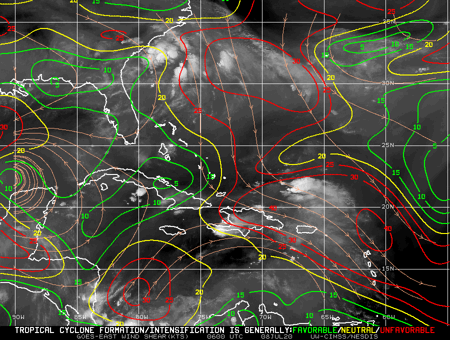

In the modeling at least it is beginning to appear more and more likely that the system will miss the first connection OTS. You can see in the image below in the upper left corner Gordons remnants aid in pumping the ridging out ahead of it through diabetic processes as mentioned by Armando's write up Mugsy posted above. The SSTA support such a process basically reconnecting the ridging in the NE Atlantic with the NW Atlantic effectively trapping Florence beneath it steering it westward.


Now be careful. First: A missed connection is still not a foregone conclusion although becoming less likely.
Second: If Florence misses the first bus an EC landfall is still not guaranteed. It is still possible that the strength of the system combined with other factors I don't have time to get into may cause an eroding of the western flank of the ridge such that she stalls and or turns north before making landfall and gets lifted out with the next passing trough. That said this scenario would still end up too close for comfort. And of course a direct EC landfall is also entirely plausible.
We will know if the first bus is going to pick up Flornece pretty darn soon...by Sunday or so +/- 12-24hrs with definitive confidence. soooooooo
WE TRACK!!!!!

_________________
"In weather and in life, there's no winning and losing; there's only winning and learning."
WINTER 2012/2013 TOTALS 43.65"WINTER 2017/2018 TOTALS 62.85" WINTER 2022/2023 TOTALS 4.9"
WINTER 2013/2014 TOTALS 64.85"WINTER 2018/2019 TOTALS 14.25" WINTER 2023/2024 TOTALS 13.1"
WINTER 2014/2015 TOTALS 71.20"WINTER 2019/2020 TOTALS 6.35"
WINTER 2015/2016 TOTALS 35.00"WINTER 2020/2021 TOTALS 37.75"
WINTER 2016/2017 TOTALS 42.25"WINTER 2021/2022 TOTALS 31.65"

sroc4- Admin

- Posts : 8331
Reputation : 301
Join date : 2013-01-07
Location : Wading River, LI
Re: 2018 Hurricane Season
![]() by jmanley32 Thu Sep 06, 2018 7:48 am
by jmanley32 Thu Sep 06, 2018 7:48 am
jmanley32- Senior Enthusiast
- Posts : 20513
Reputation : 108
Join date : 2013-12-12
Age : 42
Location : Yonkers, NY
Re: 2018 Hurricane Season
![]() by rb924119 Thu Sep 06, 2018 7:55 am
by rb924119 Thu Sep 06, 2018 7:55 am
rb924119- Meteorologist

- Posts : 6889
Reputation : 194
Join date : 2013-02-06
Age : 32
Location : Greentown, Pa
Re: 2018 Hurricane Season
![]() by skinsfan1177 Thu Sep 06, 2018 8:14 am
by skinsfan1177 Thu Sep 06, 2018 8:14 am

skinsfan1177- Senior Enthusiast
- Posts : 4485
Reputation : 35
Join date : 2013-01-07
Age : 46
Location : Point Pleasant Boro
Re: 2018 Hurricane Season
![]() by Sanchize06 Thu Sep 06, 2018 8:22 am
by Sanchize06 Thu Sep 06, 2018 8:22 am
skinsfan1177 wrote:Imo if she becomes a cat 5 I think it's ots weaker storm better shot at east coast
I agree. I think if it's as strong as the GFS suggests in the 920mb range, it's more north and breaks down the ridge and turns OTS before reaching the coast. CMC and EURO showing landfall makes sense because a weaker system should be forced more west by the ridge
Sanchize06- Senior Enthusiast
- Posts : 1041
Reputation : 21
Join date : 2013-02-05
Location : Union Beach, NJ
Page 7 of 18 • 1 ... 6, 7, 8 ... 12 ... 18 ![]()
|
|
|