
 Search
Weekend Sub/Tropical Storm Threat 9/30
Page 1 of 2 • 1, 2 ![]()

Weekend Sub/Tropical Storm Threat 9/30
![]() by Dunnzoo Tue Sep 24, 2013 12:32 pm
by Dunnzoo Tue Sep 24, 2013 12:32 pm

Dunnzoo- Senior Enthusiast - Mod

- Posts : 4892
Reputation : 68
Join date : 2013-01-11
Age : 62
Location : Westwood, NJ
Re: Weekend Sub/Tropical Storm Threat 9/30
![]() by Frank_Wx Tue Sep 24, 2013 12:34 pm
by Frank_Wx Tue Sep 24, 2013 12:34 pm


Frank_Wx- Godzilla Seeker

- Posts : 21305
Reputation : 328
Join date : 2013-01-05
Age : 31
Location : Jersey City, NJ -

Re: Weekend Sub/Tropical Storm Threat 9/30
![]() by Frank_Wx Tue Sep 24, 2013 1:07 pm
by Frank_Wx Tue Sep 24, 2013 1:07 pm

Frank_Wx- Godzilla Seeker
- Posts : 21305
Reputation : 328
Join date : 2013-01-05
Age : 31
Location : Jersey City, NJ -
Weekend Sub-Tropical Storm Threat 9/30
![]() by Frank_Wx Tue Sep 24, 2013 1:16 pm
by Frank_Wx Tue Sep 24, 2013 1:16 pm

Frank_Wx- Godzilla Seeker
- Posts : 21305
Reputation : 328
Join date : 2013-01-05
Age : 31
Location : Jersey City, NJ -
Frank_Wx- Godzilla Seeker
- Posts : 21305
Reputation : 328
Join date : 2013-01-05
Age : 31
Location : Jersey City, NJ -
Re: Weekend Sub/Tropical Storm Threat 9/30
![]() by Frank_Wx Tue Sep 24, 2013 2:22 pm
by Frank_Wx Tue Sep 24, 2013 2:22 pm
Frank_Wx- Godzilla Seeker
- Posts : 21305
Reputation : 328
Join date : 2013-01-05
Age : 31
Location : Jersey City, NJ -
Re: Weekend Sub/Tropical Storm Threat 9/30
![]() by Frank_Wx Tue Sep 24, 2013 2:25 pm
by Frank_Wx Tue Sep 24, 2013 2:25 pm
Frank_Wx- Godzilla Seeker
- Posts : 21305
Reputation : 328
Join date : 2013-01-05
Age : 31
Location : Jersey City, NJ -

Frank_Wx- Godzilla Seeker
- Posts : 21305
Reputation : 328
Join date : 2013-01-05
Age : 31
Location : Jersey City, NJ -
Re: Weekend Sub/Tropical Storm Threat 9/30
![]() by Quietace Tue Sep 24, 2013 3:08 pm
by Quietace Tue Sep 24, 2013 3:08 pm
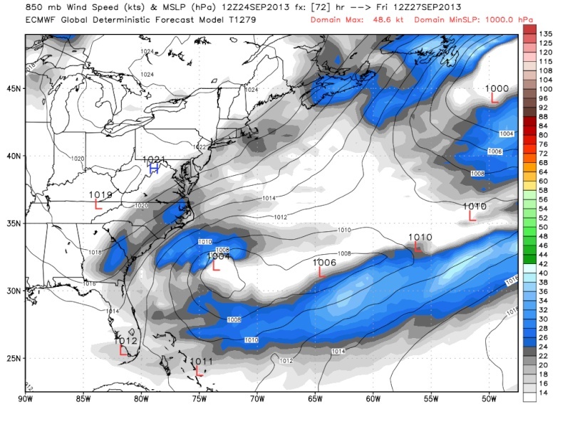

12z Euro above
One thing to note about the GEM is that it is always way to aggressive on strength of the circulation and tends to really rapidly deepen the low which in this case could allow it to drive further away from the coast originally before engaging with the trough, allowing it make the left turn and on this run to far east miss us....just
The looking at the EURO is making me cringe....

Quietace- Meteorologist - Mod

- Posts : 3687
Reputation : 33
Join date : 2013-01-07
Age : 27
Location : Point Pleasant, NJ
Re: Weekend Sub/Tropical Storm Threat 9/30
![]() by amugs Tue Sep 24, 2013 4:36 pm
by amugs Tue Sep 24, 2013 4:36 pm
_________________
Mugs
AKA:King: Snow Weenie
Self Proclaimed
WINTER 2014-15 : 55.12" +.02 for 6 coatings (avg. 35")
WINTER 2015-16 Total - 29.8" (Avg 35")
WINTER 2016-17 : 39.5" so far

amugs- Advanced Forecaster - Mod
- Posts : 15093
Reputation : 213
Join date : 2013-01-07
Age : 54
Location : Hillsdale,NJ
Re: Weekend Sub/Tropical Storm Threat 9/30
![]() by Quietace Tue Sep 24, 2013 7:15 pm
by Quietace Tue Sep 24, 2013 7:15 pm
Giving me sad chills saying this....

Quietace- Meteorologist - Mod
- Posts : 3687
Reputation : 33
Join date : 2013-01-07
Age : 27
Location : Point Pleasant, NJ
Re: Weekend Sub/Tropical Storm Threat 9/30
![]() by amugs Tue Sep 24, 2013 7:27 pm
by amugs Tue Sep 24, 2013 7:27 pm
Just heard Nick Gregory on Channel 5 and Channel 4 both said it is something to watch for Sun into Monday with what Frank said in last week that he saw on the GFS 6Z the other day with a trop storm forming in the GOM and crossing Fla coming out over the Atlantic and then up the coast. Both pro mets also noted that they "hope" it goes OTS and doesn't curve back to the coast -Nick said and his map showed area just east of NYC and channel 4 showed NYC - only time will tell but never say never with the weather - Sandy 2.0?? Maybe we spoke to soon - we shall see.....
_________________
Mugs
AKA:King: Snow Weenie
Self Proclaimed
WINTER 2014-15 : 55.12" +.02 for 6 coatings (avg. 35")
WINTER 2015-16 Total - 29.8" (Avg 35")
WINTER 2016-17 : 39.5" so far
amugs- Advanced Forecaster - Mod
- Posts : 15093
Reputation : 213
Join date : 2013-01-07
Age : 54
Location : Hillsdale,NJ
Re: Weekend Sub/Tropical Storm Threat 9/30
![]() by Quietace Tue Sep 24, 2013 7:35 pm
by Quietace Tue Sep 24, 2013 7:35 pm
Mugs,amugs wrote:Okay,
Just heard Nick Gregory on Channel 5 and Channel 4 both said it is something to watch for Sun into Monday with what Frank said in last week that he saw on the GFS 6Z the other day with a trop storm forming in the GOM and crossing Fla coming out over the Atlantic and then up the coast. Both pro mets also noted that they "hope" it goes OTS and doesn't curve back to the coast -Nick said and his map showed area just east of NYC and channel 4 showed NYC - only time will tell but never say never with the weather - Sandy 2.0?? Maybe we spoke to soon - we shall see.....
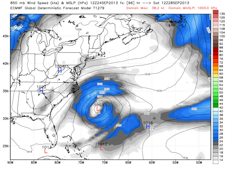
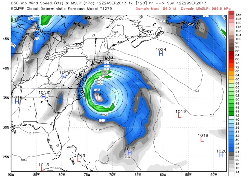
Pro mets will down play the potential for a few more days until they know for certain it will be a hit or go OTS. So honestly just give credit they actually mentioned it. All we know now is that the big 3 all have a storm develop and make a left hook interacting with the cold front. Euro brings the system right into the area, and the GEM and GFS are just offshore with the intensity differing. The EURO is coming into its lock down zone so if the 0z run holds at the 0z/12z track i would be worried. But seeing how the GFS has drastically made shifts to the EURO Camp with every run today is even more a bit concerning to me that the EURO is handling the system correctly. The GFS is still as mentioned before a progressive biased model so it could still be wanting to locate the center to far to the east then it should be. I just pray that the intensity stays minimal with this system as most models keep it around (except of course the GEM) 990-995+mb.
Actually re-examining the GEM, the GFS is actually a hair closer to the coast with the LP
Quietace- Meteorologist - Mod
- Posts : 3687
Reputation : 33
Join date : 2013-01-07
Age : 27
Location : Point Pleasant, NJ
Re: Weekend Sub/Tropical Storm Threat 9/30
![]() by amugs Tue Sep 24, 2013 8:40 pm
by amugs Tue Sep 24, 2013 8:40 pm
_________________
Mugs
AKA:King: Snow Weenie
Self Proclaimed
WINTER 2014-15 : 55.12" +.02 for 6 coatings (avg. 35")
WINTER 2015-16 Total - 29.8" (Avg 35")
WINTER 2016-17 : 39.5" so far
amugs- Advanced Forecaster - Mod
- Posts : 15093
Reputation : 213
Join date : 2013-01-07
Age : 54
Location : Hillsdale,NJ
Re: Weekend Sub/Tropical Storm Threat 9/30
![]() by Quietace Tue Sep 24, 2013 8:47 pm
by Quietace Tue Sep 24, 2013 8:47 pm
Also look at NCEP site, and tropical tidbits
Quietace- Meteorologist - Mod
- Posts : 3687
Reputation : 33
Join date : 2013-01-07
Age : 27
Location : Point Pleasant, NJ
Re: Weekend Sub/Tropical Storm Threat 9/30
![]() by amugs Tue Sep 24, 2013 8:53 pm
by amugs Tue Sep 24, 2013 8:53 pm
_________________
Mugs
AKA:King: Snow Weenie
Self Proclaimed
WINTER 2014-15 : 55.12" +.02 for 6 coatings (avg. 35")
WINTER 2015-16 Total - 29.8" (Avg 35")
WINTER 2016-17 : 39.5" so far
amugs- Advanced Forecaster - Mod
- Posts : 15093
Reputation : 213
Join date : 2013-01-07
Age : 54
Location : Hillsdale,NJ
Re: Weekend Sub/Tropical Storm Threat 9/30
![]() by Quietace Tue Sep 24, 2013 8:56 pm
by Quietace Tue Sep 24, 2013 8:56 pm
Schools tough with AP and honors classes up to about 3 am every night. And im still sitting the sideline with soccer because of health problems (my heart) and i hate every second of it and its literately killing me from the inside out not being out their with the guys...amugs wrote:Thanks kid - how is school n soccer?
Quietace- Meteorologist - Mod
- Posts : 3687
Reputation : 33
Join date : 2013-01-07
Age : 27
Location : Point Pleasant, NJ
Re: Weekend Sub/Tropical Storm Threat 9/30
![]() by aiannone Tue Sep 24, 2013 9:01 pm
by aiannone Tue Sep 24, 2013 9:01 pm
_________________
-Alex Iannone-

aiannone- Senior Enthusiast - Mod
- Posts : 4814
Reputation : 92
Join date : 2013-01-07
Location : Saint James, LI (Northwest Suffolk Co.)
Re: Weekend Sub/Tropical Storm Threat 9/30
![]() by Frank_Wx Tue Sep 24, 2013 9:07 pm
by Frank_Wx Tue Sep 24, 2013 9:07 pm
Alex! Holy crap good luckMets2695 wrote:Hey guys. I've been off for a while due to my busy schedule and the quiet weather and have mainly just been lurking the AWE board on FB but with this potential coastal storm late this weekend I will try to be on here as much as possible. Actually, I am going up to Vermont this Friday to attend instant decision day at Lyndon State College in Vermont for meteorology. Looks and sounds like an awesome school. I can't wait! Anyway, looking forward to talking with you all again!
Frank_Wx- Godzilla Seeker
- Posts : 21305
Reputation : 328
Join date : 2013-01-05
Age : 31
Location : Jersey City, NJ -
Re: Weekend Sub/Tropical Storm Threat 9/30
![]() by amugs Tue Sep 24, 2013 9:08 pm
by amugs Tue Sep 24, 2013 9:08 pm
_________________
Mugs
AKA:King: Snow Weenie
Self Proclaimed
WINTER 2014-15 : 55.12" +.02 for 6 coatings (avg. 35")
WINTER 2015-16 Total - 29.8" (Avg 35")
WINTER 2016-17 : 39.5" so far
amugs- Advanced Forecaster - Mod
- Posts : 15093
Reputation : 213
Join date : 2013-01-07
Age : 54
Location : Hillsdale,NJ
Re: Weekend Sub/Tropical Storm Threat 9/30
![]() by amugs Tue Sep 24, 2013 9:10 pm
by amugs Tue Sep 24, 2013 9:10 pm
Mugs
_________________
Mugs
AKA:King: Snow Weenie
Self Proclaimed
WINTER 2014-15 : 55.12" +.02 for 6 coatings (avg. 35")
WINTER 2015-16 Total - 29.8" (Avg 35")
WINTER 2016-17 : 39.5" so far
amugs- Advanced Forecaster - Mod
- Posts : 15093
Reputation : 213
Join date : 2013-01-07
Age : 54
Location : Hillsdale,NJ
Re: Weekend Sub/Tropical Storm Threat 9/30
![]() by aiannone Tue Sep 24, 2013 9:32 pm
by aiannone Tue Sep 24, 2013 9:32 pm
Yea I think I am making the right choice going there. I like smaller schools and that's a big reason why I don't want to go to Penn state and I think I can get just as good of an education at Lyndon as well as smaller class sizes to help me learn and interact with professors. That's a big perk because the professors there have a lot of of connections which you need in the weather business. Anyway, I see no reason as of now why Lyndon would be a bad decision, and if any of think it would be a bad decision or heard bad things about it please let me know!amugs wrote:Hey Mets - a phenomenal school for Meteorology - I had a student go there back in the late 90's early 2000's and he played soccer and studied meteorology - was All American in soccer and got a job with NOAA upon graduation - stationed in Alaska - you will love it - good luck!
_________________
-Alex Iannone-
aiannone- Senior Enthusiast - Mod
- Posts : 4814
Reputation : 92
Join date : 2013-01-07
Location : Saint James, LI (Northwest Suffolk Co.)
Re: Weekend Sub/Tropical Storm Threat 9/30
![]() by Frank_Wx Wed Sep 25, 2013 1:12 am
by Frank_Wx Wed Sep 25, 2013 1:12 am
Frank_Wx- Godzilla Seeker
- Posts : 21305
Reputation : 328
Join date : 2013-01-05
Age : 31
Location : Jersey City, NJ -
Re: Weekend Sub/Tropical Storm Threat 9/30
![]() by Snow88 Wed Sep 25, 2013 1:41 am
by Snow88 Wed Sep 25, 2013 1:41 am

Snow88- Senior Enthusiast

- Posts : 2193
Reputation : 4
Join date : 2013-01-09
Age : 35
Location : Brooklyn, NY
Re: Weekend Sub/Tropical Storm Threat 9/30
![]() by sroc4 Wed Sep 25, 2013 6:53 am
by sroc4 Wed Sep 25, 2013 6:53 am
Euro 0z 9/24:

Euro 0z 9/25

Notice just how much stronger and further west the blocking to the north extends on yesterdays 0z. Same for CMC
0z CMC 9/24

0z CMC 9/25

24-48 more hrs of consistency to the models and it looks like another beautiful weekend for most of our area is on tap, but I will hold off on that call until Thursday.
_________________
"In weather and in life, there's no winning and losing; there's only winning and learning."
WINTER 2012/2013 TOTALS 43.65"WINTER 2017/2018 TOTALS 62.85" WINTER 2022/2023 TOTALS 4.9"
WINTER 2013/2014 TOTALS 64.85"WINTER 2018/2019 TOTALS 14.25" WINTER 2023/2024 TOTALS 13.1"
WINTER 2014/2015 TOTALS 71.20"WINTER 2019/2020 TOTALS 6.35"
WINTER 2015/2016 TOTALS 35.00"WINTER 2020/2021 TOTALS 37.75"
WINTER 2016/2017 TOTALS 42.25"WINTER 2021/2022 TOTALS 31.65"

sroc4- Admin
- Posts : 8331
Reputation : 301
Join date : 2013-01-07
Location : Wading River, LI
Page 1 of 2 • 1, 2 ![]()
|
|
|