
 Search
DECEMBER 8TH 2021---First real accumulating snow potential ????
Page 1 of 2 • 1, 2 ![]()

DECEMBER 8TH 2021---First real accumulating snow potential ????
![]() by sroc4 Sun Dec 05, 2021 9:03 am
by sroc4 Sun Dec 05, 2021 9:03 am
rb924119 wrote:Now that I've had a chance to glance at tonight's 00z suites coming in, I like the trends aloft even though the surface maps are not yet where I think they will end up.
00z GFS Ensemble 500mb height anomaly trend:
00z GEM/CMC 500mb height anomaly trend:


Morning everyone!!!!! Here is the Link to Rays video he posted in the Discussions thread. I encourage everyone to take a listen. Its phenominal:
https://drive.google.com/file/d/1gonDCUaWVuA3Grk8Khi_qgno0tRQHRm5/view?usp=sharing
Ray phenomenal video! Thank you. I wish I could do video's too. I feel like it would save me so much time. I am; however, going to have to respectfully disagree with a couple of points you make. Well maybe not disagree but more point out a few key areas that I did not see you comment on and what I feel are just as important, if not more important.
I will focus on the GFS only to make my points. Some of this was already discussed in my last write up. Ray in your video you discuss the trough split of the Pac energy and discuss the piece ejecting out vs the piece that backs up off the WC. It felt like you were inferring that the energy that gets ejected ends up being the energy that is our system. This part I disagree with.

Above is hr6, or about 7am this am, from this am's 06z GFS. In addition to the trough split from the Pac energy as outlined in the video, there is a second trough split associated with the trough in the Sub Trop region. Its this energy that gets ejected that will eventually give rise to the LP that develops near or just off the coast. The energy that gets ejected from the Pac energy ends up strung out along the boundary layer that develops from the system that passes late tomorrow night. The other area not mentioned in the video are the two circles not labeled. The one over the N plains CONUS is the late Mon system that heads towards Greenland. The one to its N is another key factor IMHO that I mentioned in my prior discussion. Ill get back to this point shortly
Fast forward to Hr 72:


Above is the same image zoomed in on the CONUS view. Notice that there ae two troughs out lined. One N of th GL and the other digging into the plains. Each has its own pivot point. What seems to be very clear to me in the evolution in the modeling is the positioning of that trough N of the great lakes. This feature is absolutely vital in preventing heights from increasing ahead of the system.
Look below to Hr 81 on this mornings 6z. BUT FIRST lets look at the same time stamp Wed 15z from yesterdays 12z GFS that I posted in my prev discussion and compare it to this mornings 06z run and pay attention to where that trough N of the GL is. With it further east and north on yesterdays 12z run there is no resistance to the height increase from the trough digging into the Plains phasing into the boundary layer. The result is a LP track into the Tenn Vally, and a much warmer soln on yest 12z. Vs the 6z from this am the placement of the GL trough is acting to limit the ability to raise heights leading to a colder soln relatively speaking when comp to12z yest.


Briefly getting back to this point I made at the beginning of todays discussion:
The other area not mentioned in the video are the two circles not labeled. The one over the N plains CONUS is the late Mon system that heads towards Greenland. The one to its N is another key factor IMHO that I mentioned in my prior discussion.
The trend for the Monday system is to be further S from prev. First image is yesterdays 12z map and the second is this mornings 6z both valid for 15z Wed.


You can see the center is now south of Greenland's SE tip compared to yesterdays 12z run where it was due east of Greenland's SE tip. In addition to that, look at the map below. It shows the GFS trends. The area I have circled is the energy I have labeled #3 in the discussion maps above and you can clearly see it is trending darker blue which means lower pressure in the area just N of the GL. Again this energy/feature offers the only resistance against the otherwise immediate surge of the warm layers as energy #2 phases with #1 because both the Pac and Atlantic pattern does not offer any real help at all.

Myself, Ray(rb, Frank, Heehaw, Mugsy, Al etc., have all pointed out that we are not in a great pattern for snow. But as I have also pointed out in the past, it can still snow in shitty patterns when things come together just right. We just need BABY BEAR. (My Baby Bear here on Long Island may be slightly diff than Baby bear N&W of NYC, but you get the point)
We still have a little ways to go to see how we trend last minute. The GFS is def still the warmest and wettest soln but it is on its own at the moment and has 100% been trending colder due to the things I outlined above. The Euro, CMC, and now NAM(although NAM still not in its wheelhouse yet) all have a much more suppressed colder soln overall. To me the trend towards a colder soln has been clear across all models, keeping the entire region, including the immediate coast in play for accumulation, but remember very tiny changes at 500mb can lead to much larger changes at the surface for better or worse (warmer or colder)(wetter or dryer-OTS) relative to your specific location so stay tuned as we are approaching game time.
WE TRACK!!!!!


Last edited by sroc4 on Sun Dec 05, 2021 9:29 am; edited 3 times in total
_________________
"In weather and in life, there's no winning and losing; there's only winning and learning."
WINTER 2012/2013 TOTALS 43.65"WINTER 2017/2018 TOTALS 62.85" WINTER 2022/2023 TOTALS 4.9"
WINTER 2013/2014 TOTALS 64.85"WINTER 2018/2019 TOTALS 14.25" WINTER 2023/2024 TOTALS 13.1"
WINTER 2014/2015 TOTALS 71.20"WINTER 2019/2020 TOTALS 6.35"
WINTER 2015/2016 TOTALS 35.00"WINTER 2020/2021 TOTALS 37.75"
WINTER 2016/2017 TOTALS 42.25"WINTER 2021/2022 TOTALS 31.65"

sroc4- Admin

- Posts : 8331
Reputation : 301
Join date : 2013-01-07
Location : Wading River, LI
amugs, kalleg, weatherwatchermom and SENJsnowman like this post
Re: DECEMBER 8TH 2021---First real accumulating snow potential ????
![]() by amugs Sun Dec 05, 2021 9:16 am
by amugs Sun Dec 05, 2021 9:16 am
I just wrote in the other thread that Mondays system plays a crucial role in Tuesdays storm. Trend has been colder for sure which is great to see. We shall see what the next 12 -24 hours bring us. Fun times ahead to track.
_________________
Mugs
AKA:King: Snow Weenie
Self Proclaimed
WINTER 2014-15 : 55.12" +.02 for 6 coatings (avg. 35")
WINTER 2015-16 Total - 29.8" (Avg 35")
WINTER 2016-17 : 39.5" so far

amugs- Advanced Forecaster - Mod

- Posts : 15093
Reputation : 213
Join date : 2013-01-07
Age : 54
Location : Hillsdale,NJ
sroc4 likes this post
Re: DECEMBER 8TH 2021---First real accumulating snow potential ????
![]() by Wheezer Sun Dec 05, 2021 9:36 am
by Wheezer Sun Dec 05, 2021 9:36 am
Wheezer- Posts : 30
Reputation : 6
Join date : 2017-11-08
Location : Cincinnati, Oh
Re: DECEMBER 8TH 2021---First real accumulating snow potential ????
![]() by aiannone Sun Dec 05, 2021 10:31 am
by aiannone Sun Dec 05, 2021 10:31 am


_________________
-Alex Iannone-

aiannone- Senior Enthusiast - Mod
- Posts : 4813
Reputation : 92
Join date : 2013-01-07
Location : Saint James, LI (Northwest Suffolk Co.)
Re: DECEMBER 8TH 2021---First real accumulating snow potential ????
![]() by aiannone Sun Dec 05, 2021 10:34 am
by aiannone Sun Dec 05, 2021 10:34 am

_________________
-Alex Iannone-
aiannone- Senior Enthusiast - Mod
- Posts : 4813
Reputation : 92
Join date : 2013-01-07
Location : Saint James, LI (Northwest Suffolk Co.)
Re: DECEMBER 8TH 2021---First real accumulating snow potential ????
![]() by heehaw453 Sun Dec 05, 2021 12:05 pm
by heehaw453 Sun Dec 05, 2021 12:05 pm
heehaw453- Advanced Forecaster

- Posts : 3906
Reputation : 86
Join date : 2014-01-20
Location : Bedminster Township, PA Elevation 600' ASL
Re: DECEMBER 8TH 2021---First real accumulating snow potential ????
![]() by sroc4 Sun Dec 05, 2021 12:57 pm
by sroc4 Sun Dec 05, 2021 12:57 pm
heehaw453 wrote:Most of the 12Z guidance wants nothing to do with this threat. Flat as a pancake trough, no height rises on EC and really no shortwave energy. The CMC at the H5 is dramatically different than 3 runs ago. Sampling of the shortwave energy occurs tonight and by tomorrow 12Z the verdict will be reached IMO.
Hopefully it's a case of over correcting followed by the slow walk back towards where it should be. The windshield wipers. Euro is rolling now. Lets see

_________________
"In weather and in life, there's no winning and losing; there's only winning and learning."
WINTER 2012/2013 TOTALS 43.65"WINTER 2017/2018 TOTALS 62.85" WINTER 2022/2023 TOTALS 4.9"
WINTER 2013/2014 TOTALS 64.85"WINTER 2018/2019 TOTALS 14.25" WINTER 2023/2024 TOTALS 13.1"
WINTER 2014/2015 TOTALS 71.20"WINTER 2019/2020 TOTALS 6.35"
WINTER 2015/2016 TOTALS 35.00"WINTER 2020/2021 TOTALS 37.75"
WINTER 2016/2017 TOTALS 42.25"WINTER 2021/2022 TOTALS 31.65"
sroc4- Admin
- Posts : 8331
Reputation : 301
Join date : 2013-01-07
Location : Wading River, LI
weatherwatchermom likes this post
Re: DECEMBER 8TH 2021---First real accumulating snow potential ????
![]() by sroc4 Sun Dec 05, 2021 1:09 pm
by sroc4 Sun Dec 05, 2021 1:09 pm
_________________
"In weather and in life, there's no winning and losing; there's only winning and learning."
WINTER 2012/2013 TOTALS 43.65"WINTER 2017/2018 TOTALS 62.85" WINTER 2022/2023 TOTALS 4.9"
WINTER 2013/2014 TOTALS 64.85"WINTER 2018/2019 TOTALS 14.25" WINTER 2023/2024 TOTALS 13.1"
WINTER 2014/2015 TOTALS 71.20"WINTER 2019/2020 TOTALS 6.35"
WINTER 2015/2016 TOTALS 35.00"WINTER 2020/2021 TOTALS 37.75"
WINTER 2016/2017 TOTALS 42.25"WINTER 2021/2022 TOTALS 31.65"
sroc4- Admin
- Posts : 8331
Reputation : 301
Join date : 2013-01-07
Location : Wading River, LI
Re: DECEMBER 8TH 2021---First real accumulating snow potential ????
![]() by dkodgis Sun Dec 05, 2021 7:59 pm
by dkodgis Sun Dec 05, 2021 7:59 pm

dkodgis- Senior Enthusiast

- Posts : 2494
Reputation : 98
Join date : 2013-12-29
Re: DECEMBER 8TH 2021---First real accumulating snow potential ????
![]() by sroc4 Sun Dec 05, 2021 8:15 pm
by sroc4 Sun Dec 05, 2021 8:15 pm
_________________
"In weather and in life, there's no winning and losing; there's only winning and learning."
WINTER 2012/2013 TOTALS 43.65"WINTER 2017/2018 TOTALS 62.85" WINTER 2022/2023 TOTALS 4.9"
WINTER 2013/2014 TOTALS 64.85"WINTER 2018/2019 TOTALS 14.25" WINTER 2023/2024 TOTALS 13.1"
WINTER 2014/2015 TOTALS 71.20"WINTER 2019/2020 TOTALS 6.35"
WINTER 2015/2016 TOTALS 35.00"WINTER 2020/2021 TOTALS 37.75"
WINTER 2016/2017 TOTALS 42.25"WINTER 2021/2022 TOTALS 31.65"
sroc4- Admin
- Posts : 8331
Reputation : 301
Join date : 2013-01-07
Location : Wading River, LI
rb924119 and bloc1357 like this post
Re: DECEMBER 8TH 2021---First real accumulating snow potential ????
![]() by rb924119 Sun Dec 05, 2021 8:29 pm
by rb924119 Sun Dec 05, 2021 8:29 pm
dkodgis wrote:Any model updates?
I’ve not had time to really post a thoughtful response to Scott’s rebuttal of my video, but the trends that I highlighted appear to have continued today, though the reflections across the GFS, GEM, and Euro suites appear to remain generally unchanged for now. With three days to go, though, there’s a lot of time for further adjustments one way or another. That’s about all I can offer at the moment. I’ll probably post after I get off work early in the morning.
rb924119- Meteorologist

- Posts : 6889
Reputation : 194
Join date : 2013-02-06
Age : 32
Location : Greentown, Pa
Re: DECEMBER 8TH 2021---First real accumulating snow potential ????
![]() by Irish Sun Dec 05, 2021 9:36 pm
by Irish Sun Dec 05, 2021 9:36 pm

Irish- Pro Enthusiast

- Posts : 788
Reputation : 19
Join date : 2019-01-16
Age : 45
Location : Old Bridge, NJ
Re: DECEMBER 8TH 2021---First real accumulating snow potential ????
![]() by jmanley32 Sun Dec 05, 2021 9:50 pm
by jmanley32 Sun Dec 05, 2021 9:50 pm

jmanley32- Senior Enthusiast
- Posts : 20513
Reputation : 108
Join date : 2013-12-12
Age : 42
Location : Yonkers, NY
rb924119 likes this post
Re: DECEMBER 8TH 2021---First real accumulating snow potential ????
![]() by rb924119 Sun Dec 05, 2021 11:23 pm
by rb924119 Sun Dec 05, 2021 11:23 pm
Irish wrote:Seems like the storm threat is fading.
Not saying that I believe it, but before you start counting chickens, you should let the 00z suite finish hatching its eggs
Much like Major Tom commencing countdown, we are commencing our northward trend. How far will it go? Only one way to find out……..WE TRACK!!!
rb924119- Meteorologist
- Posts : 6889
Reputation : 194
Join date : 2013-02-06
Age : 32
Location : Greentown, Pa
Re: DECEMBER 8TH 2021---First real accumulating snow potential ????
![]() by rb924119 Sun Dec 05, 2021 11:25 pm
by rb924119 Sun Dec 05, 2021 11:25 pm
jmanley32 wrote:Hey all, so the models showing a far south solution very sharp cutoff to north of 95, not sure where steve D is getting his 3-6 for a area that far north. I have not seen all the model runs but man few days ago the GFS had 6-12 for the area. It has been pretty warm though so not sure how much of that would actually stick. It would be nice to see at least a little white, even better to have a decent storm that would last through xmas but looking at temp forecasts i think that's asking a bit much, we will see. Been working hard at my new job (just hit 6 mos dec. 1st) and getting ready to start-up ebay as a full fledged business for 2022 and going forward so haven't had much time for weather sadly. Great explanations though I did not have time to read in entirety.
I’ve been wondering you were haha glad to see you back, and glad to hear things are going well! Latest GFS isn’t too far off from Steve’s thoughts, so he may not be as crazy as he seems :p
rb924119- Meteorologist
- Posts : 6889
Reputation : 194
Join date : 2013-02-06
Age : 32
Location : Greentown, Pa
Re: DECEMBER 8TH 2021---First real accumulating snow potential ????
![]() by Irish Mon Dec 06, 2021 4:34 am
by Irish Mon Dec 06, 2021 4:34 am
rb924119 wrote:Irish wrote:Seems like the storm threat is fading.
Not saying that I believe it, but before you start counting chickens, you should let the 00z suite finish hatching its eggs
Much like Major Tom commencing countdown, we are commencing our northward trend. How far will it go? Only one way to find out……..WE TRACK!!!
Oh, I'm more than happy to wait to count, as I'd rather see more eggs.
TRACK AWAY!
Irish- Pro Enthusiast
- Posts : 788
Reputation : 19
Join date : 2019-01-16
Age : 45
Location : Old Bridge, NJ
Re: DECEMBER 8TH 2021---First real accumulating snow potential ????
![]() by amugs Mon Dec 06, 2021 7:01 am
by amugs Mon Dec 06, 2021 7:01 am
Euro/Ukie/CMC are a miss for the area but Euor not by much. Adjustments will be occuring either way
Scott you Fish Stix can't buy a win right now
_________________
Mugs
AKA:King: Snow Weenie
Self Proclaimed
WINTER 2014-15 : 55.12" +.02 for 6 coatings (avg. 35")
WINTER 2015-16 Total - 29.8" (Avg 35")
WINTER 2016-17 : 39.5" so far
amugs- Advanced Forecaster - Mod
- Posts : 15093
Reputation : 213
Join date : 2013-01-07
Age : 54
Location : Hillsdale,NJ
heehaw453 likes this post
Re: DECEMBER 8TH 2021---First real accumulating snow potential ????
![]() by heehaw453 Mon Dec 06, 2021 9:42 am
by heehaw453 Mon Dec 06, 2021 9:42 am
heehaw453- Advanced Forecaster
- Posts : 3906
Reputation : 86
Join date : 2014-01-20
Location : Bedminster Township, PA Elevation 600' ASL
sroc4 and amugs like this post
Re: DECEMBER 8TH 2021---First real accumulating snow potential ????
![]() by amugs Mon Dec 06, 2021 9:56 am
by amugs Mon Dec 06, 2021 9:56 am

_________________
Mugs
AKA:King: Snow Weenie
Self Proclaimed
WINTER 2014-15 : 55.12" +.02 for 6 coatings (avg. 35")
WINTER 2015-16 Total - 29.8" (Avg 35")
WINTER 2016-17 : 39.5" so far
amugs- Advanced Forecaster - Mod
- Posts : 15093
Reputation : 213
Join date : 2013-01-07
Age : 54
Location : Hillsdale,NJ
Re: DECEMBER 8TH 2021---First real accumulating snow potential ????
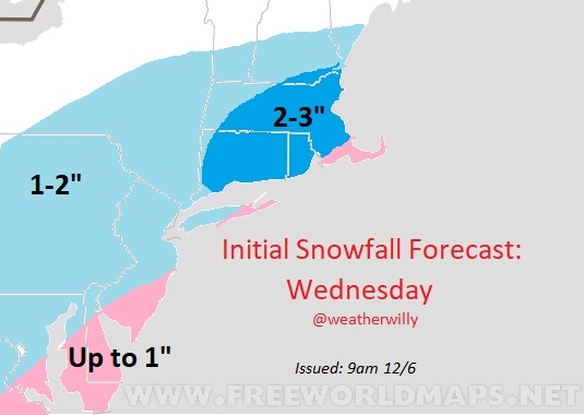
![]() by SENJsnowman Mon Dec 06, 2021 10:01 am
by SENJsnowman Mon Dec 06, 2021 10:01 am
It’s the most wonderful time…of the year!!!
SENJsnowman- Senior Enthusiast
- Posts : 1186
Reputation : 61
Join date : 2017-01-06
Age : 51
Location : Bayville, NJ
amugs, heehaw453 and weatherwatchermom like this post
Re: DECEMBER 8TH 2021---First real accumulating snow potential ????
![]() by sroc4 Mon Dec 06, 2021 10:05 am
by sroc4 Mon Dec 06, 2021 10:05 am
_________________
"In weather and in life, there's no winning and losing; there's only winning and learning."
WINTER 2012/2013 TOTALS 43.65"WINTER 2017/2018 TOTALS 62.85" WINTER 2022/2023 TOTALS 4.9"
WINTER 2013/2014 TOTALS 64.85"WINTER 2018/2019 TOTALS 14.25" WINTER 2023/2024 TOTALS 13.1"
WINTER 2014/2015 TOTALS 71.20"WINTER 2019/2020 TOTALS 6.35"
WINTER 2015/2016 TOTALS 35.00"WINTER 2020/2021 TOTALS 37.75"
WINTER 2016/2017 TOTALS 42.25"WINTER 2021/2022 TOTALS 31.65"
sroc4- Admin
- Posts : 8331
Reputation : 301
Join date : 2013-01-07
Location : Wading River, LI
heehaw453 and weatherwatchermom like this post
Re: DECEMBER 8TH 2021---First real accumulating snow potential ????
![]() by sroc4 Mon Dec 06, 2021 10:10 am
by sroc4 Mon Dec 06, 2021 10:10 am
_________________
"In weather and in life, there's no winning and losing; there's only winning and learning."
WINTER 2012/2013 TOTALS 43.65"WINTER 2017/2018 TOTALS 62.85" WINTER 2022/2023 TOTALS 4.9"
WINTER 2013/2014 TOTALS 64.85"WINTER 2018/2019 TOTALS 14.25" WINTER 2023/2024 TOTALS 13.1"
WINTER 2014/2015 TOTALS 71.20"WINTER 2019/2020 TOTALS 6.35"
WINTER 2015/2016 TOTALS 35.00"WINTER 2020/2021 TOTALS 37.75"
WINTER 2016/2017 TOTALS 42.25"WINTER 2021/2022 TOTALS 31.65"
sroc4- Admin
- Posts : 8331
Reputation : 301
Join date : 2013-01-07
Location : Wading River, LI
Re: DECEMBER 8TH 2021---First real accumulating snow potential ????
![]() by amugs Mon Dec 06, 2021 10:23 am
by amugs Mon Dec 06, 2021 10:23 am
_________________
Mugs
AKA:King: Snow Weenie
Self Proclaimed
WINTER 2014-15 : 55.12" +.02 for 6 coatings (avg. 35")
WINTER 2015-16 Total - 29.8" (Avg 35")
WINTER 2016-17 : 39.5" so far
amugs- Advanced Forecaster - Mod
- Posts : 15093
Reputation : 213
Join date : 2013-01-07
Age : 54
Location : Hillsdale,NJ
Re: DECEMBER 8TH 2021---First real accumulating snow potential ????
![]() by amugs Mon Dec 06, 2021 10:28 am
by amugs Mon Dec 06, 2021 10:28 am
What else is new these days??sroc4 wrote:NAM was a Suffolk County special
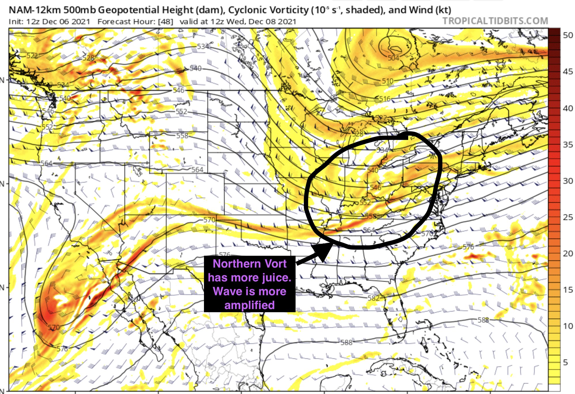
A tad more amplification is still possible in this mal pattern we are in. IF we had a sharper PNA or a bit of a block then it could be really interesting overall as it stands a little teaser but mood happening event. He does a good job depicting upper levels comparisons.
06Z and 12Z difference from Nam 12k. There is a still higher ceiling for this storm believe it or not. Earlier consolidation of the vort max and a bit more amplification in the shortwave we could tap into. Have time too but idk if it will actually happen or not. No guarantees pic.twitter.com/SQUOwrWiMg
— BGWX (@BradyBGWX) December 6, 2021
Non Twitter folks here are the maps:

_________________
Mugs
AKA:King: Snow Weenie
Self Proclaimed
WINTER 2014-15 : 55.12" +.02 for 6 coatings (avg. 35")
WINTER 2015-16 Total - 29.8" (Avg 35")
WINTER 2016-17 : 39.5" so far
amugs- Advanced Forecaster - Mod
- Posts : 15093
Reputation : 213
Join date : 2013-01-07
Age : 54
Location : Hillsdale,NJ
Re: DECEMBER 8TH 2021---First real accumulating snow potential ????
![]() by heehaw453 Mon Dec 06, 2021 10:55 am
by heehaw453 Mon Dec 06, 2021 10:55 am
heehaw453- Advanced Forecaster
- Posts : 3906
Reputation : 86
Join date : 2014-01-20
Location : Bedminster Township, PA Elevation 600' ASL
amugs, weatherwatchermom and phil155 like this post
Sponsored content
Page 1 of 2 • 1, 2 ![]()
|
|
|