
 Search
Long Range Discussion 23.0
Page 23 of 26 •  1 ... 13 ... 22, 23, 24, 25, 26
 ![]()
Re: Long Range Discussion 23.0
![]() by Frank_Wx Tue Jan 25, 2022 9:50 pm
by Frank_Wx Tue Jan 25, 2022 9:50 pm
Frank_Wx- Godzilla Seeker

- Posts : 21305
Join date : 2013-01-05 -

jmanley32 and heehaw453 like this post
Re: Long Range Discussion 23.0
![]() by Irish Tue Jan 25, 2022 9:56 pm
by Irish Tue Jan 25, 2022 9:56 pm
Irish- Pro Enthusiast

- Posts : 788
Join date : 2019-01-16
Re: Long Range Discussion 23.0
![]() by heehaw453 Tue Jan 25, 2022 9:58 pm
by heehaw453 Tue Jan 25, 2022 9:58 pm

heehaw453- Advanced Forecaster

- Posts : 3906
Reputation : 86
Join date : 2014-01-20
Location : Bedminster Township, PA Elevation 600' ASL
Re: Long Range Discussion 23.0
![]() by rb924119 Tue Jan 25, 2022 10:01 pm
by rb924119 Tue Jan 25, 2022 10:01 pm
rb924119- Meteorologist

- Posts : 6890
Reputation : 194
Join date : 2013-02-06
Age : 32
Location : Greentown, Pa
heehaw453 likes this post
Re: Long Range Discussion 23.0
![]() by jmanley32 Tue Jan 25, 2022 10:02 pm
by jmanley32 Tue Jan 25, 2022 10:02 pm
Unfortunently probably not soon enough, if this happens verbatim DOT etc would need 1-2 days to fully prepare so if NWS does not pull trigger on Watches at least by tomorrow 00z then they aren't leaving much time which often can happen. We will have to wait and see the GFS, CMC and Euro, if all 3 models agree I think they couod pull trigger tomorrow night.Irish wrote:When do the networks start warning people of the possible magnitude of this storm?

jmanley32- Senior Enthusiast

- Posts : 20517
Reputation : 108
Join date : 2013-12-12
Age : 42
Location : Yonkers, NY
Re: Long Range Discussion 23.0
![]() by jmanley32 Tue Jan 25, 2022 10:04 pm
by jmanley32 Tue Jan 25, 2022 10:04 pm
about mixing or even rain I presume? I really hope that does not become a issue for anyone.rb924119 wrote:Just my early musings here based on almost nothing, but I this has plenty of west trend left in it, in my opinion. If I’m southeast of I-95, which I am, it would have me worried. BUT, it’s a good thing I haven’t looked at much, and these thoughts are nearly pointless lol
jmanley32- Senior Enthusiast
- Posts : 20517
Reputation : 108
Join date : 2013-12-12
Age : 42
Location : Yonkers, NY
Re: Long Range Discussion 23.0
![]() by Irish Tue Jan 25, 2022 10:08 pm
by Irish Tue Jan 25, 2022 10:08 pm
jmanley32 wrote:about mixing or even rain I presume? I really hope that does not become a issue for anyone.rb924119 wrote:Just my early musings here based on almost nothing, but I this has plenty of west trend left in it, in my opinion. If I’m southeast of I-95, which I am, it would have me worried. BUT, it’s a good thing I haven’t looked at much, and these thoughts are nearly pointless lol
I think it would be extreme SE NJ at worst.

Irish- Pro Enthusiast
- Posts : 788
Reputation : 19
Join date : 2019-01-16
Age : 45
Location : Old Bridge, NJ
Re: Long Range Discussion 23.0
![]() by Irish Tue Jan 25, 2022 10:14 pm
by Irish Tue Jan 25, 2022 10:14 pm
Irish- Pro Enthusiast
- Posts : 788
Reputation : 19
Join date : 2019-01-16
Age : 45
Location : Old Bridge, NJ
Re: Long Range Discussion 23.0
![]() by rb924119 Tue Jan 25, 2022 10:24 pm
by rb924119 Tue Jan 25, 2022 10:24 pm
I’d be careful here. Like I said, I haven’t but peeked at some things, but the orientation and location of the ridge axis is a bit of a red flag to me. The axis of the main ridge is notably negative, which (in theory) would translate to an earlier negative tilt of the main trough axis. Tilt the trough negative more quickly/earlier phase, closer storm track. Also more potent. Not to mention, the underestimation of latent heat release into the down stream ridge via convective and ambient processes is also quite likely, which would further aid in sharpening/backing the flow to more south-southeasterly downstream of the trough axis, instead of allowing it to remain more southwesterly. Just some early things Im looking at.Irish wrote:jmanley32 wrote:about mixing or even rain I presume? I really hope that does not become a issue for anyone.rb924119 wrote:Just my early musings here based on almost nothing, but I this has plenty of west trend left in it, in my opinion. If I’m southeast of I-95, which I am, it would have me worried. BUT, it’s a good thing I haven’t looked at much, and these thoughts are nearly pointless lol
I think it would be extreme SE NJ at worst.
rb924119- Meteorologist
- Posts : 6890
Reputation : 194
Join date : 2013-02-06
Age : 32
Location : Greentown, Pa
SENJsnowman likes this post
Re: Long Range Discussion 23.0
![]() by rb924119 Tue Jan 25, 2022 10:27 pm
by rb924119 Tue Jan 25, 2022 10:27 pm
rb924119- Meteorologist
- Posts : 6890
Reputation : 194
Join date : 2013-02-06
Age : 32
Location : Greentown, Pa
Re: Long Range Discussion 23.0
![]() by Frank_Wx Tue Jan 25, 2022 10:30 pm
by Frank_Wx Tue Jan 25, 2022 10:30 pm
_________________
_______________________________________________________________________________________________________
CLICK HERE to view NJ Strong Snowstorm Classifications

Frank_Wx- Godzilla Seeker
- Posts : 21305
Reputation : 328
Join date : 2013-01-05
Age : 31
Location : Jersey City, NJ -
Re: Long Range Discussion 23.0
![]() by rb924119 Tue Jan 25, 2022 10:33 pm
by rb924119 Tue Jan 25, 2022 10:33 pm
Frank_Wx wrote:00z RGEM missed the phase. Well east
So that means the GEM will be well east as well. Classic model chaos continues.
rb924119- Meteorologist
- Posts : 6890
Reputation : 194
Join date : 2013-02-06
Age : 32
Location : Greentown, Pa
Re: Long Range Discussion 23.0
![]() by Frank_Wx Tue Jan 25, 2022 10:38 pm
by Frank_Wx Tue Jan 25, 2022 10:38 pm
rb924119 wrote:Frank_Wx wrote:00z RGEM missed the phase. Well east
So that means the GEM will be well east as well. Classic model chaos continues.
Actually we saw divergence between the two yesterday. RGEM was an absolute bomb while 00z CMC was well east.
_________________
_______________________________________________________________________________________________________
CLICK HERE to view NJ Strong Snowstorm Classifications
Frank_Wx- Godzilla Seeker
- Posts : 21305
Reputation : 328
Join date : 2013-01-05
Age : 31
Location : Jersey City, NJ -
Re: Long Range Discussion 23.0
![]() by rb924119 Tue Jan 25, 2022 10:40 pm
by rb924119 Tue Jan 25, 2022 10:40 pm
Frank_Wx wrote:rb924119 wrote:Frank_Wx wrote:00z RGEM missed the phase. Well east
So that means the GEM will be well east as well. Classic model chaos continues.
Actually we saw divergence between the two yesterday. RGEM was an absolute bomb while 00z CMC was well east.
Yeah, but in my experience that’s pretty uncommon.
rb924119- Meteorologist
- Posts : 6890
Reputation : 194
Join date : 2013-02-06
Age : 32
Location : Greentown, Pa
Re: Long Range Discussion 23.0
![]() by hyde345 Tue Jan 25, 2022 10:43 pm
by hyde345 Tue Jan 25, 2022 10:43 pm
rb924119 wrote:I’d be careful here. Like I said, I haven’t but peeked at some things, but the orientation and location of the ridge axis is a bit of a red flag to me. The axis of the main ridge is notably negative, which (in theory) would translate to an earlier negative tilt of the main trough axis. Tilt the trough negative more quickly/earlier phase, closer storm track. Also more potent. Not to mention, the underestimation of latent heat release into the down stream ridge via convective and ambient processes is also quite likely, which would further aid in sharpening/backing the flow to more south-southeasterly downstream of the trough axis, instead of allowing it to remain more southwesterly. Just some early things Im looking at.Irish wrote:jmanley32 wrote:about mixing or even rain I presume? I really hope that does not become a issue for anyone.rb924119 wrote:Just my early musings here based on almost nothing, but I this has plenty of west trend left in it, in my opinion. If I’m southeast of I-95, which I am, it would have me worried. BUT, it’s a good thing I haven’t looked at much, and these thoughts are nearly pointless lol
I think it would be extreme SE NJ at worst.
NWS Albany in their latest discussion was talking about the down stream ridge and latent heat release and how models don't pick that up right away.

hyde345- Pro Enthusiast
- Posts : 1082
Reputation : 48
Join date : 2013-01-08
Location : Hyde Park, NY
Re: Long Range Discussion 23.0
![]() by hyde345 Tue Jan 25, 2022 10:45 pm
by hyde345 Tue Jan 25, 2022 10:45 pm
Frank_Wx wrote:00z RGEM missed the phase. Well east
It was still a tad west of its 18z run when you look at 29/06z time stamp.
hyde345- Pro Enthusiast
- Posts : 1082
Reputation : 48
Join date : 2013-01-08
Location : Hyde Park, NY
Re: Long Range Discussion 23.0
![]() by rb924119 Tue Jan 25, 2022 10:45 pm
by rb924119 Tue Jan 25, 2022 10:45 pm
hyde345 wrote:rb924119 wrote:I’d be careful here. Like I said, I haven’t but peeked at some things, but the orientation and location of the ridge axis is a bit of a red flag to me. The axis of the main ridge is notably negative, which (in theory) would translate to an earlier negative tilt of the main trough axis. Tilt the trough negative more quickly/earlier phase, closer storm track. Also more potent. Not to mention, the underestimation of latent heat release into the down stream ridge via convective and ambient processes is also quite likely, which would further aid in sharpening/backing the flow to more south-southeasterly downstream of the trough axis, instead of allowing it to remain more southwesterly. Just some early things Im looking at.Irish wrote:jmanley32 wrote:about mixing or even rain I presume? I really hope that does not become a issue for anyone.rb924119 wrote:Just my early musings here based on almost nothing, but I this has plenty of west trend left in it, in my opinion. If I’m southeast of I-95, which I am, it would have me worried. BUT, it’s a good thing I haven’t looked at much, and these thoughts are nearly pointless lol
I think it would be extreme SE NJ at worst.
NWS Albany in their latest discussion was talking about the down stream ridge and latent heat release and how models don't pick that up right away.
Oh really?? Do you know the initials of the author?? I interned there when I was in college, so I’m just curious haha
rb924119- Meteorologist
- Posts : 6890
Reputation : 194
Join date : 2013-02-06
Age : 32
Location : Greentown, Pa
Re: Long Range Discussion 23.0
![]() by CPcantmeasuresnow Tue Jan 25, 2022 10:48 pm
by CPcantmeasuresnow Tue Jan 25, 2022 10:48 pm

CPcantmeasuresnow- Wx Statistician Guru

- Posts : 7274
Reputation : 230
Join date : 2013-01-07
Age : 103
Location : Eastern Orange County, NY
Frank_Wx, rb924119, crippo84, Lauraanne2, jmanley32 and dkodgis like this post
Re: Long Range Discussion 23.0
![]() by rb924119 Tue Jan 25, 2022 10:48 pm
by rb924119 Tue Jan 25, 2022 10:48 pm
rb924119- Meteorologist
- Posts : 6890
Reputation : 194
Join date : 2013-02-06
Age : 32
Location : Greentown, Pa
Re: Long Range Discussion 23.0
![]() by Frank_Wx Tue Jan 25, 2022 10:49 pm
by Frank_Wx Tue Jan 25, 2022 10:49 pm
_________________
_______________________________________________________________________________________________________
CLICK HERE to view NJ Strong Snowstorm Classifications
Frank_Wx- Godzilla Seeker
- Posts : 21305
Reputation : 328
Join date : 2013-01-05
Age : 31
Location : Jersey City, NJ -
Re: Long Range Discussion 23.0
![]() by rb924119 Tue Jan 25, 2022 10:50 pm
by rb924119 Tue Jan 25, 2022 10:50 pm
rb924119- Meteorologist
- Posts : 6890
Reputation : 194
Join date : 2013-02-06
Age : 32
Location : Greentown, Pa
Re: Long Range Discussion 23.0
![]() by Frank_Wx Tue Jan 25, 2022 10:51 pm
by Frank_Wx Tue Jan 25, 2022 10:51 pm
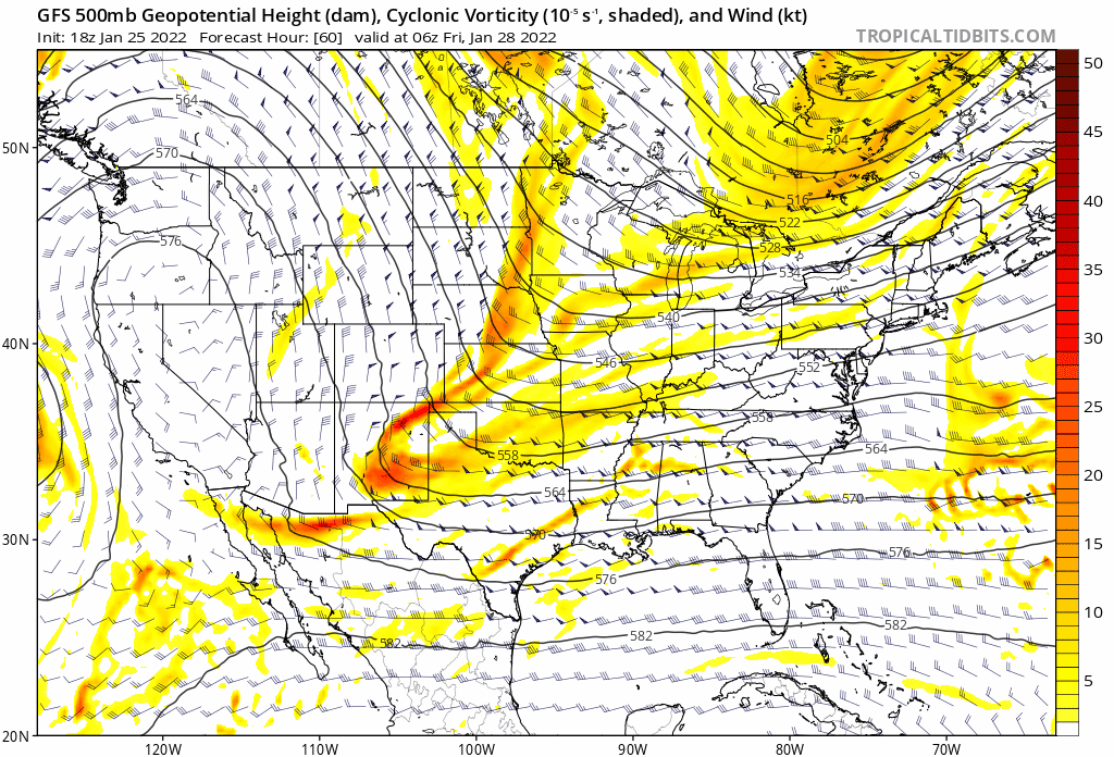
rb924119 wrote:Interesting changes with the lead energy on the GFS so far. A little less potent and a little further east than previous runs as it drops through the Rockies. Theoretically, this should be an improvement as it should help mitigate any lallygagging, but we’ll see.
Ooof...I don't know. I'm seeing the southern vort lag behind (or the northern vort scoot ahead depending how you look at it). They are not as vertically aligned as 18z.
_________________
_______________________________________________________________________________________________________
CLICK HERE to view NJ Strong Snowstorm Classifications
Frank_Wx- Godzilla Seeker
- Posts : 21305
Reputation : 328
Join date : 2013-01-05
Age : 31
Location : Jersey City, NJ -
Re: Long Range Discussion 23.0
![]() by Frank_Wx Tue Jan 25, 2022 10:52 pm
by Frank_Wx Tue Jan 25, 2022 10:52 pm
Frank_Wx wrote:rb924119 wrote:Interesting changes with the lead energy on the GFS so far. A little less potent and a little further east than previous runs as it drops through the Rockies. Theoretically, this should be an improvement as it should help mitigate any lallygagging, but we’ll see.
Ooof...I don't know. I'm seeing the southern vort lag behind (or the northern vort scoot ahead depending how you look at it). They are not as vertically aligned as 18z.
_________________
_______________________________________________________________________________________________________
CLICK HERE to view NJ Strong Snowstorm Classifications
Frank_Wx- Godzilla Seeker
- Posts : 21305
Reputation : 328
Join date : 2013-01-05
Age : 31
Location : Jersey City, NJ -
Re: Long Range Discussion 23.0
![]() by Frank_Wx Tue Jan 25, 2022 10:53 pm
by Frank_Wx Tue Jan 25, 2022 10:53 pm
_________________
_______________________________________________________________________________________________________
CLICK HERE to view NJ Strong Snowstorm Classifications
Frank_Wx- Godzilla Seeker
- Posts : 21305
Reputation : 328
Join date : 2013-01-05
Age : 31
Location : Jersey City, NJ -
Re: Long Range Discussion 23.0
![]() by rb924119 Tue Jan 25, 2022 10:54 pm
by rb924119 Tue Jan 25, 2022 10:54 pm
Frank_Wx wrote:Frank_Wx wrote:rb924119 wrote:Interesting changes with the lead energy on the GFS so far. A little less potent and a little further east than previous runs as it drops through the Rockies. Theoretically, this should be an improvement as it should help mitigate any lallygagging, but we’ll see.
Ooof...I don't know. I'm seeing the southern vort lag behind (or the northern vort scoot ahead depending how you look at it). They are not as vertically aligned as 18z.
That’s only compared to 18z, though. Compare it to the last three or four cycles. Either way, this is why I am leaving the play call to you haha
rb924119- Meteorologist
- Posts : 6890
Reputation : 194
Join date : 2013-02-06
Age : 32
Location : Greentown, Pa
Re: Long Range Discussion 23.0
![]() by hyde345 Tue Jan 25, 2022 10:55 pm
by hyde345 Tue Jan 25, 2022 10:55 pm
rb924119 wrote:hyde345 wrote:rb924119 wrote:I’d be careful here. Like I said, I haven’t but peeked at some things, but the orientation and location of the ridge axis is a bit of a red flag to me. The axis of the main ridge is notably negative, which (in theory) would translate to an earlier negative tilt of the main trough axis. Tilt the trough negative more quickly/earlier phase, closer storm track. Also more potent. Not to mention, the underestimation of latent heat release into the down stream ridge via convective and ambient processes is also quite likely, which would further aid in sharpening/backing the flow to more south-southeasterly downstream of the trough axis, instead of allowing it to remain more southwesterly. Just some early things Im looking at.Irish wrote:jmanley32 wrote:about mixing or even rain I presume? I really hope that does not become a issue for anyone.rb924119 wrote:Just my early musings here based on almost nothing, but I this has plenty of west trend left in it, in my opinion. If I’m southeast of I-95, which I am, it would have me worried. BUT, it’s a good thing I haven’t looked at much, and these thoughts are nearly pointless lol
I think it would be extreme SE NJ at worst.
NWS Albany in their latest discussion was talking about the down stream ridge and latent heat release and how models don't pick that up right away.
Oh really?? Do you know the initials of the author?? I interned there when I was in college, so I’m just curious haha
I copied the entire discussion below:
FXUS61 KALY 260251
AFDALY
AREA FORECAST DISCUSSION
National Weather Service Albany NY
951 PM EST Tue Jan 25 2022
.SYNOPSIS...
Another cold air mass will move down across the area from
Canada over through Thursday with below normal temperatures.
Temperatures in the Adirondacks will fall below zero tonight,
then many locations will be near or below zero Wednesday night.
A storm system off the east coast will threaten our area with a
chance for snow and wind later Friday or Saturday.
&&
.NEAR TERM /THROUGH WEDNESDAY/...
Update as of 950 PM EST...
Wind Chill Advisory is in effect 1 am to 9 am EST WED for the
southern Adirondacks.
A cold front will move across the region over. The low- level
moisture has been limited. The 00Z KALY sounding had a PWAT of
0.14" with low-level dry below 750 hPa. Some diffuse snow
showers and flurries have been across the western Mohawk Valley,
Schoharie Valley and northern Catskills. Little or no
accumulation is occurring and these should shrivel up around
midnight. The flow is veering the west to northwest with
southwest flow aloft. The degree of low-level dry air will
limit the activity with a lowering inversion.
We diminished clouds east of the Hudson River Valley based on
the satellite imagery. Temps will fall with the cold advection
with the frontal passage. Wind Chills will lower to 15 to 25
below over the southern Adirondacks overnight, where an
advisory will be in effect. Lows will be in the single digits
and teens with below zero readings over the Adirondack Park, and
western Mohawk Valley and northern Catskills.
Previous near term...
A wind chill advisory is in effect for the southern Adirondacks
late tonight through Wednesday morning. Scattered snow showers
will persist into early this evening. There is still a
possibility that a few snow showers could move down the Mohawk
Valley late this afternoon producing a dusting of snow along the
I-90 corridor, but in general accumulations will be minimal.
Arctic air will overspread the area tonight with dryer
conditions and a wind shift from west to northwest which should
allow for the snow showers to diminish and shift westward away
from our area this evening. Skies will clear overnight.
Temperatures will fall to below zero over the Adirondacks with
light winds allowing wind chills to approach -20 and we have
gone with a wind chill advisory for that area for late tonight.
Elsewhere, temperatures will fall to the single digits with wind
chills of zero to 10 below in many areas.
&&
.SHORT TERM /WEDNESDAY NIGHT THROUGH THURSDAY/...
Arctic high pressure will cover the area Wednesday into Thursday
with another round of well below normal temperatures. Wednesday
will feature plenty of sunshine with high pressure moving
overhead. High temperatures will only be in the teens in most
areas, with some 20s in the mid-Hudson Valley and single digits
across the north country. Wednesday night will be clear with
light winds and very cold with lows in many places getting below
zero. This will be somewhat similar to the low temperatures that
we experienced last week in that there will be wide ranges of
temperature due to the light winds and clear skies. Some
locations in the Adirondacks will likely fall to at least -20
while other areas in the Hudson Valley may stay just above zero.
High pressure will move off the east coast on Thursday. Sunshine
will fade behind increasing clouds as a cold front approaches
from the northwest. After highs in the 20s on Thursday, clouds
and a southwest breeze will keep temperatures from falling much
Thursday night.
During Friday our attention will turn to a storm system
developing off the mid-Atlantic coast. Moisture spreading north
ahead of this system will interact with a shallow frontal
boundary moving south of our area keeping clouds in the forecast
along with an increasing chance for light snow during the day.
The pressure gradient between the storm off the coast and high
pressure to our north will allow for a north wind to be
increasing through the day. Temperatures will recover to near
normal in many places with highs in the 20s to mid 30s. Details
on the evolution of the storm Friday night into the weekend will
be covered in the extended portion of this discussion.
&&
.LONG TERM /THURSDAY NIGHT THROUGH TUESDAY/...
Main story for the long term is a strong coastal storm that may
impact the region Friday night into Saturday. At this time,
there is high confidence that a storm will develop, but low
confidence as to the track. While there is the potential for a
major storm for somewhere in the northeast, considerable
uncertainty in the storm track means that impacts to our
forecast area remain uncertain as well. It is too early to
estimate snowfall amounts, but will include a full analysis of
current thinking and sources of uncertainty below...
At 00z Saturday, long term begins with a large upper trough
extending from Canada down to the Gulf Coast moving across the
eastern third of the country. As this trough moves eastward Friday
night and Saturday, it will become neutrally to negatively tilted,
and surface cyclogenesis will take place off the U.S. east coast. As
this storm tracks northeastward, it is expected to rapidly deepen,
and may undergo bombogenesis (drop in central pressure of 24 mb in
24 hrs). With ample cold air in place, expecting precipitation to
fall as all snow for our region. Also, it will become breezy due to
a tight pressure gradient over the region, with some sources of
guidance suggesting the central pressure of the storm deepens into
the 960-970 mb range. Snow may begin as early as late Friday
afternoon and last into Saturday night, with the highest chance for
snow during the day Saturday.
While confidence is high in an impactful storm somewhere along the
east coast, there are several sources of uncertainty in the storm
track and therefore impacts to our region. One major source of
uncertainty is the degree of phasing on Friday between a northern
stream disturbance diving south from Manitoba and a southern stream
disturbance over Texas and New Mexico. At this time, it appears the
norther stream disturbance will take a favorable track for these
disturbances to phase, but there are more questions surrounding the
southern stream. The GFS is stronger and further to the southwest
with the souther stream disturbance, resulting in a later phase/less
phasing between the two disturbances. The result is a more
positively tilted and progressive upper trough and a storm track
further to the east. The Euro, on the other hand, has a weaker
southern stream disturbance that does not dig as far south and west.
This allows the southern stream disturbance to move out ahead of the
norther stream wave Friday and Friday night. The result is a more
negatively tilted upper trough and a storm track further to the
west. The Euro has held steady over the past few runs, while the GFS
has trended towards the Euro each of the past three runs after the
18z GFS yesterday was much further east with the storm track.
To add even more uncertainty to the forecast, Stony Brook
Sensitivity analysis developed through CSTAR research suggests that
the eventual track of the storm will also be sensitive to the
strength of the upper ridge that develops downstream of the trough
(as is usually the case with these large east coast storms). A
stronger ridge will be associated with a storm track further to the
west; this is seen in the Euro solution as well. Often, but not
always, models underestimate the strength of the downstream ridge in
the medium-range as they cannot resolve the diabatic ridge-building
due to latent heat release. With ample moisture from the Gulf of
Mexico, it is certainly possible that this trend will manifest
itself with this storm as well. Will note at this time that both the
GEFS and EPS have a subset of ensemble members tucked in closer to
the coast than the operational models suggest, suggesting that a
track further north and west remains possible. Finally, right
entrance region of an upper jet over our region and the fact that
banded snowfall on the northwestern side of major east coast
cyclones often occurs further north and west than modeled, there is
still the potential for a precipitation shield that extends further
to the west than guidance shows. Therefore, accumulating snow is
possible further west than modeled, even with the eastern storm
track. Hopefully, will be able to gain more insights into possible
solutions by comparing model guidance to RAOB observations over the
next 24 hours as upper energy comes onshore.
In terms of the impacts from this potential storm, a GFS-like track
would result in a glancing blow for most of the region. Western New
England would see a plowable snowfall, while areas to the west of
the Hudson River would see only very light snowfall amounts.
However, a Euro-like solution would result in a heavy snowfall for
all of our western New England zones, with heavy amounts potentially
extending as far west as the eastern Catskills and Mohawk Valley. In
a worst case scenario with a storm track further inland, blizzard
conditions would not be out of the question somewhere in the
northeast, but it is far from a guarantee that this will happen.
With this forecast package, opted to take an ensemble approach and
stayed relatively close to NBM guidance due to large uncertainty and
inconsistencies between various sources of guidance. Therefore,
included snow likely for western New England, with snow showers
for the rest of the region further west at this time. There remains
too much uncertainty at this time to give estimates of snowfall
totals. However, will continue to message that while the outcome
remains uncertain, a worst-case scenario would result in a major
snow storm for at least our western New England zones.
After the storm pulls away late Saturday or Saturday night, winds
should remain breezy for some time before gradually decreasing as
high pressure builds in from the west. While it will remain cold,
tranquil weather is expected to continue through the beginning of
next week in the wake of the storm.
&&
.AVIATION /03Z WEDNESDAY THROUGH SUNDAY/...
VFR conditions will prevail through the end of the TAF period.
While some mid-level clouds with ceilings near 5-7kft are
streaming towards ALB and PSF this evening due to upstream lake
effect activity, these clouds will be directed south of the
region by 03 - 06 UTC as winds veer to the northwest. After
that, skies will clear and remain mainly clear through 00
UTC/Wed.
Westerly winds this evening sustained 5-8kts will shift to the north-
northwest overnight and remain sustained near 5kts. By tomorrow
afternoon winds should shift to the northeast as high pressure moves
into New England.Outlook...
Wednesday Night: No Operational Impact. NO SIG WX.
Thursday: No Operational Impact. NO SIG WX.
Thursday Night: Low Operational Impact. Slight Chance of SHSN.
Friday: Moderate Operational Impact. Chance of SHSN.
Friday Night: Moderate Operational Impact. Chance of SN.
Saturday: Moderate Operational Impact. Chance of SN.
Saturday Night: Low Operational Impact. Breezy. Slight Chance of SN.
Sunday: Low Operational Impact. Breezy. NO SIG WX.ght Chance of SN.
Sunday: Low Operational Impact. Breezy. NO SIG WX.
&&
.HYDROLOGY...
River and reservoir levels are expected to remain below
flood stage over the next 7 days.
Ice across the area will thicken and expand over the next week
with continued below normal temperatures expected. Ice is
already causing widespread problems with river gauge readings.
For details on specific area rivers and lakes, including
observed and forecast river stages and lake elevations, please
visit the Advanced Hydrologic Prediction Service /AHPS/ graphs
on our website.
&&
.ALY WATCHES/WARNINGS/ADVISORIES...
CT...None.
NY...Wind Chill Advisory from 1 AM to 9 AM EST Wednesday for NYZ032-
033-042.
MA...None.
VT...None.
&&
$$
SYNOPSIS...MSE/Wasula
NEAR TERM...MSE/Wasula
SHORT TERM...MSE
LONG TERM...Main
AVIATION...Speciale
HYDROLOGY...NAS
hyde345- Pro Enthusiast
- Posts : 1082
Reputation : 48
Join date : 2013-01-08
Location : Hyde Park, NY
Re: Long Range Discussion 23.0
![]() by Frank_Wx Tue Jan 25, 2022 10:59 pm
by Frank_Wx Tue Jan 25, 2022 10:59 pm
This is a direct result of sloppy phasing and a poorly oriented northern stream
We really need 2 things:
1. Southern stream to eject out of the SW (which really does not seem to be a big concern anymore)
2. Northern stream to dig into the central CONUS and begin phasing with southern stream around the TN valley

_________________
_______________________________________________________________________________________________________
CLICK HERE to view NJ Strong Snowstorm Classifications
Frank_Wx- Godzilla Seeker
- Posts : 21305
Reputation : 328
Join date : 2013-01-05
Age : 31
Location : Jersey City, NJ -
Page 23 of 26 • 1 ... 13 ... 22, 23, 24, 25, 26 ![]()
|
|
|