
 Search
February 27th-28th 2023 Winter Storm
Page 1 of 10 • 1, 2, 3, 4, 5, 6, 7, 8, 9, 10 ![]()

February 27th-28th 2023 Winter Storm
![]() by Frank_Wx Sun Feb 26, 2023 9:00 pm
by Frank_Wx Sun Feb 26, 2023 9:00 pm
sroc4 wrote:Morning Folks. Lets get right into it. I'm pretty confident we are going to see accumulation snow Monday night into Tuesday morning if you live north of, draw a line SW to NE, between say Trenton NJ to Sandy hook out to Montauk point. South of there will struggle.
A few key points:
1) We have needed to see our 500mb energy stay south of Long Island. All models have trended to this soln; however, there are still subtle differences to just how far south and how strong and concentrated vs more strung out is it between models. (Below is GFS and Euro 500mb vort maps. Notice these differences)
2) Point two: If you have been following along this past week I have wanted to see the SOI remain negative through the weekend. Reason for this is that all winter it has remained in mod positive territory which is a La Nina base state. Combined with the MJO prev running through warm phases 3-4-5-6, this base state of the atmosphere typically allows any energy coming out of the SW CONUS to amplify over the center of the country which pumps the SE ridge, allowing the energy to bully its way into the great lakes; flooding the entire NE region with warm air ahead of our systems.
Unfortunately the SOI has trended back into positive territory over the past 3 days after only spending 3 days in the negative. https://www.longpaddock.qld.gov.au/soi/. My concern with this would be that if nothing else changed then the prev atmospheric forcing pattern that has been entrenched all winter would settle back in allowing this Mondays potential to trend right back to the GL cutter soln. BUT hold on because even though the SOI isnt ideal there are afew other big picture items that are likely to allow this to happen for Monday AND maybe even allow for the potential for the March 3rd-4th come to fruition as well. One at a time though.
3) Take a quick look back at the last two maps and notice the big circle to our NE. This is our 50/50 low. If you look at the Anomaly map notice just how green the colors are in the center. Also note the Reds to the north(our -NAO). Up until now with the aforementioned pattern entrenched, La Nina base state and MJO in warm phases, anything that has resembled a 50/50 low in the past had been easily booted as our system amplified over the central CONUS an the SE ridge flexed. But this time is def diff. Reason? the Stratospheric warming that has occurred. That's right Mugsy had been talking about this quite a bit a few couple of weeks ago, and its effects are clearly going to help us here.
Lets explore just how real quick. How exactly does a strat warm event help? This illustration is somewhat oversimplified but gets the main point across. Here is a little mind exercise. I want you to pretend you are an alien hovering high above earth centered over the north pole looking down and this is what you see.
What you are looking at here is the temp profile for the strat at about 50mb or approx 63,000 feet above sea level. Now I want to think about the fact that when air warms it expands, and when it cools it contracts. Ok. Still looking straight down at this map from space pretend that that the circle is a balloon filled with air in the stratosphere. Immediately below the balloon is another balloon over the north pole in the troposphere. Now I want you to take your space ship from hovering directly over the top of the north pole and now fly it such that you are now hovering centered over the equator. Now we are perpendicular to the north pole. So what we are visualizing here is two balloons stacked directly on top of one another centered over the north pole.
Now when we have a strat warming event I want you to visualize the fact that the air within the strat balloon is going to expand. now reference the image below. As the strat balloon expands it cannot expand further out higher in altitude because its out into space. So instead it begins to expand outward and down. As it expands down in height you can now visualize that the result is going to be to compress the tropospheric balloon below it. As you press on the center of the trop balloon, since it can compress into the surface of the ground you can imagine the balloon only being able to expand outward. (Put a balloon on a table and press down into the center of the balloon with a fist. You can see the balloon expand outward right?).
With this visual, understand that when the strat warms over the N pole like this it in essence dislodges pieces of the tropospheric polar vortex(arctic and polar air masses) southward in latitude because of the downward pressure exerted on it by a warming and expanding strat Polar vortex. Again keep your balloon analogy in mind here.
So how does this tie into our discussion about Mondays snow potential? Despite the fact that the SOI, or more appropriately put the Trop Pac forcing is still less than ideal, the DEEP 500mb trough in our 50/50 region combined with the -NAO is NOT going to budge much because of the force exerted on the troposphere from above.
THIS right here is a fundamental difference and key factor as to why this is different setup with a likely different outcome than what we've seen all winter and why accumulating snow is going to happen for many of us on this board.
So to bring this back around instead of our amplifying system over the central CONUS pumping the SE ridge and bullying its way into the GL its going to run into this 50/50low/-NAO block that isnt going to move much due to the forces exerted on it from the Strat. The result is our closed ULL w'll head into the Ohio valley before running into the block, opening up, and forced ESE, and exit the coast S of Long Island. At least thats the current consensus on the models.
Its a comlpex set up as you can see by the three LP look. There is a HP to our north with exceptionally cold air to work with as seen by this 850mb temp anomaly map. This air mass is Arctic in origin and as you can see is about 12-20*C below normal at its center.
Some of the finer details that need ironing is the fact that the surface and low mid levels will have a SE and ESE wind flow which will likely keep the surface temps above freezing along the coastal plain. Just how deep this above freezing layer is will dictate just how far away from the 10:1 snow ratio will be. I would strongly urge you all to reference the Kuch-era snow maps instead of the 10:1 maps as it is likely giving a better representation of the 6:1-8:1 ratios for the coastal plain. Once you get N of the Ct Coast the ratios are going to go up. Its still possible that we get even worse ratios along the coastal plain if the soln is closer to the GFS than Euro regarding strength and position of the energy.
Obviously no amount of snow is going to change my outlook on winter, but I am at least a little excited of the prospects of enough snow to cover my grass.
WE TRACK!!!!


_________________
_______________________________________________________________________________________________________
CLICK HERE to view NJ Strong Snowstorm Classifications

Frank_Wx- Godzilla Seeker

- Posts : 21305
Reputation : 328
Join date : 2013-01-05
Age : 31
Location : Jersey City, NJ -

JT33 likes this post
Re: February 27th-28th 2023 Winter Storm
![]() by Frank_Wx Sun Feb 26, 2023 9:00 pm
by Frank_Wx Sun Feb 26, 2023 9:00 pm
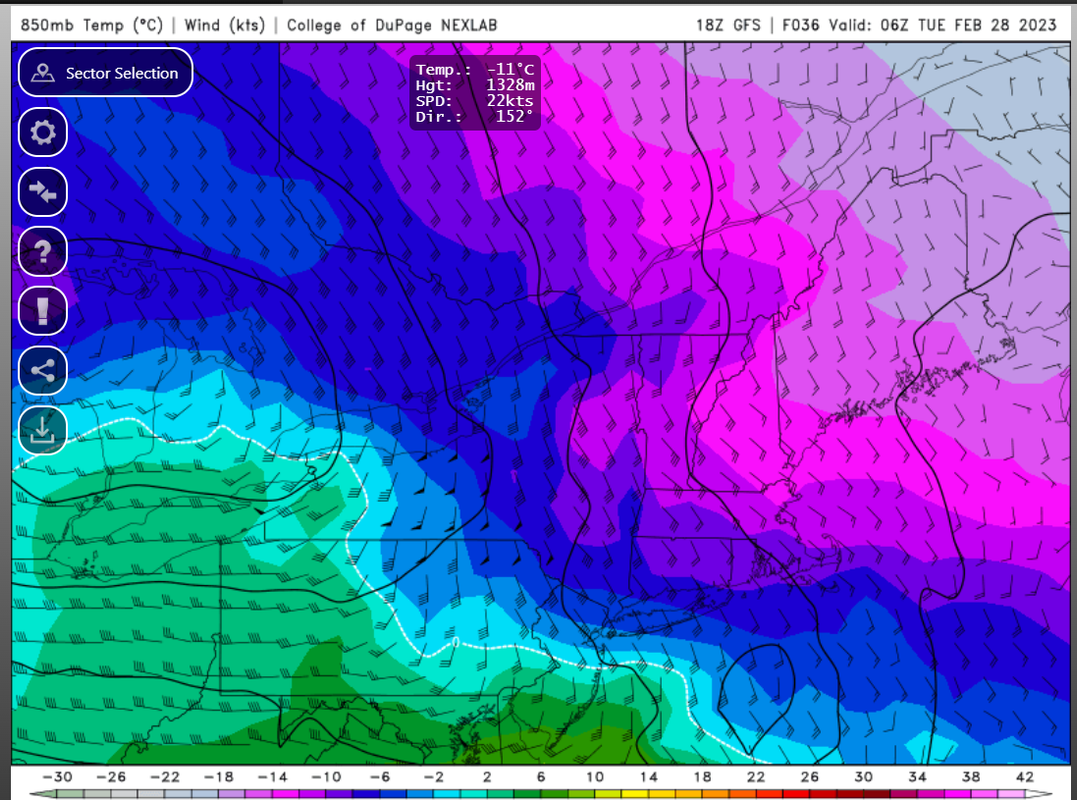
CAD - Cold Air Damming - is going to keep cold air firmly in place.
At the height of the storm, 850mb temps range from -4 to -8*C
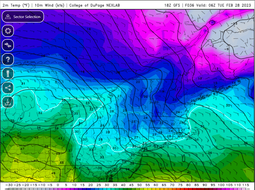
However, for the same time stamp, check out what is happening at the surface in terms of temperatures. Pay particular attention to the wind barbs. Scott mentioned this in his write-up as well, but winds are coming out of the east-southeast, and as a result surface temps are above freezing (I-80 north stays below freezing).
As I mentioned in my post earlier today, there is a lot of sloppiness happening at the 500mb level that is going to minimize snowfall amounts for NYC and points S&E. But, those N&W are primed for an all-snow event. If we had more higher latitude blocking and better organization downstream, this could have been a very nice wdespread Mothrazilla-type of an event. But, we take whatever we can get this winter!!
Here is my 1st call snow map
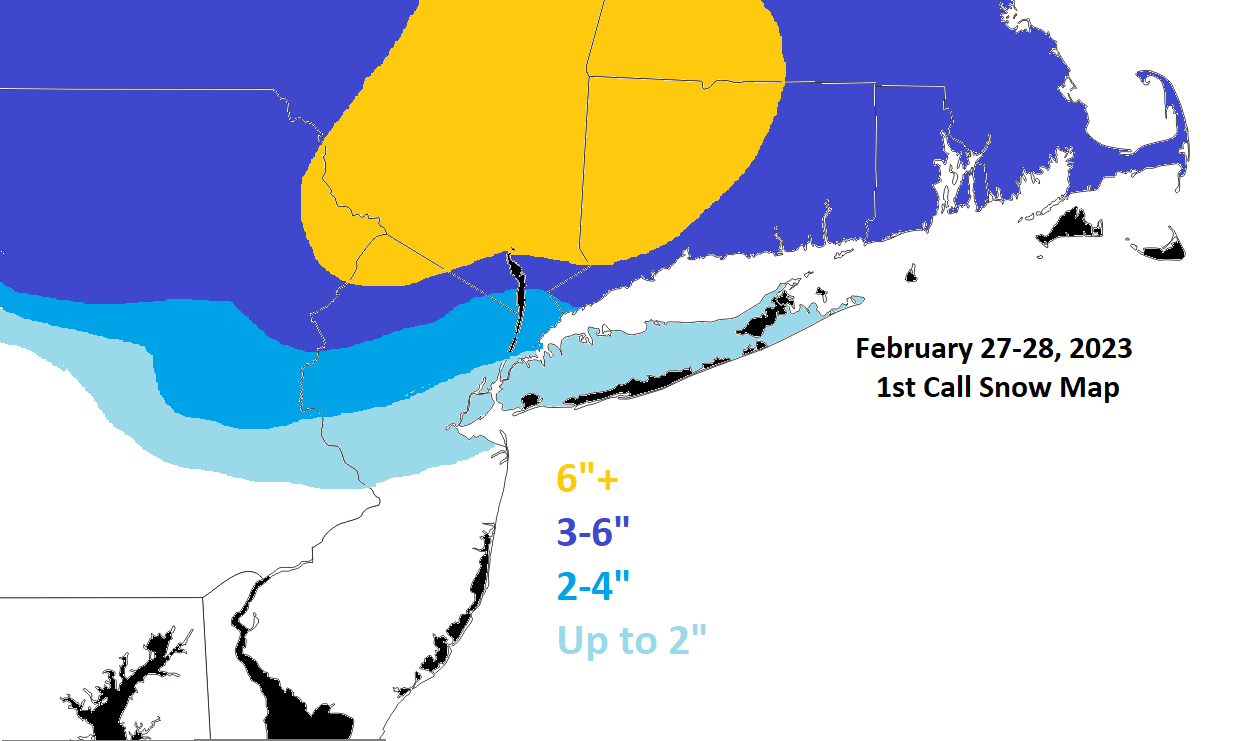
I'll intently be monitoring trends overnight and through 12z tomorrow to see if this map needs adjusting. Important to note trending is still happening, and I can see how the 2-4" line gets pulled more S&E. But, it can easily go the other direction where parts of NNJ warm up too quickly. So let's see what happens.
_________________
_______________________________________________________________________________________________________
CLICK HERE to view NJ Strong Snowstorm Classifications
Frank_Wx- Godzilla Seeker
- Posts : 21305
Reputation : 328
Join date : 2013-01-05
Age : 31
Location : Jersey City, NJ -
sroc4, docstox12, kalleg, oldtimer, heehaw453, billg315 and WinterColdandSnowisamyth like this post
Re: February 27th-28th 2023 Winter Storm
![]() by billg315 Sun Feb 26, 2023 9:13 pm
by billg315 Sun Feb 26, 2023 9:13 pm

billg315- Advanced Forecaster - Mod

- Posts : 4466
Reputation : 185
Join date : 2015-01-24
Age : 50
Location : Flemington, NJ
heehaw453 likes this post
Re: February 27th-28th 2023 Winter Storm
![]() by heehaw453 Sun Feb 26, 2023 9:20 pm
by heehaw453 Sun Feb 26, 2023 9:20 pm

heehaw453- Advanced Forecaster

- Posts : 3906
Reputation : 86
Join date : 2014-01-20
Location : Bedminster Township, PA Elevation 600' ASL
Re: February 27th-28th 2023 Winter Storm
![]() by billg315 Sun Feb 26, 2023 9:26 pm
by billg315 Sun Feb 26, 2023 9:26 pm
billg315- Advanced Forecaster - Mod
- Posts : 4466
Reputation : 185
Join date : 2015-01-24
Age : 50
Location : Flemington, NJ
heehaw453 likes this post
Re: February 27th-28th 2023 Winter Storm
![]() by Frank_Wx Sun Feb 26, 2023 9:37 pm
by Frank_Wx Sun Feb 26, 2023 9:37 pm
heehaw453 wrote:Latest HRRR. Bottom line is the trajectory of the L pressure is favorable around I78 on northward. That doesn't mean a warm nose won't invade if there is slow consolidation or rates aren't ideal. Shave off an inch if your near coast or your mid-levels are flirting with freezing. Have to look at soundings for your area. This is probably a bit overdone in all honesty.
_________________
_______________________________________________________________________________________________________
CLICK HERE to view NJ Strong Snowstorm Classifications
Frank_Wx- Godzilla Seeker
- Posts : 21305
Reputation : 328
Join date : 2013-01-05
Age : 31
Location : Jersey City, NJ -
Re: February 27th-28th 2023 Winter Storm
![]() by Frank_Wx Sun Feb 26, 2023 9:42 pm
by Frank_Wx Sun Feb 26, 2023 9:42 pm
_________________
_______________________________________________________________________________________________________
CLICK HERE to view NJ Strong Snowstorm Classifications
Frank_Wx- Godzilla Seeker
- Posts : 21305
Reputation : 328
Join date : 2013-01-05
Age : 31
Location : Jersey City, NJ -
Re: February 27th-28th 2023 Winter Storm
![]() by WinterColdandSnowisamyth Sun Feb 26, 2023 9:50 pm
by WinterColdandSnowisamyth Sun Feb 26, 2023 9:50 pm
heehaw453 wrote:Latest HRRR. Bottom line is the trajectory of the L pressure is favorable around I78 on northward. That doesn't mean a warm nose won't invade if there is slow consolidation or rates aren't ideal. Shave off an inch if your near coast or your mid-levels are flirting with freezing. Have to look at soundings for your area. This is probably a bit overdone in all honesty.
I would caution two things there. It’s a 10-1 ratio map and those can be very misleading in marginal events, especially to those on the mix line and can undercut those in the north.
Also the HRRR I’ve found disappointing this year. The RGEM has been the more reliable short term model IMO.
Will be a nowcast come go time for sure.
WinterColdandSnowisamyth- Posts : 23
Reputation : 0
Join date : 2023-02-26
Re: February 27th-28th 2023 Winter Storm
![]() by jmanley32 Sun Feb 26, 2023 10:47 pm
by jmanley32 Sun Feb 26, 2023 10:47 pm
Agree, the NAM backed off it's earlier higher amounts near coastal areas are pushed north and it changes to sleet/even rain at coast, its pretty in line with your snow map with 2-4 NYC area. I would love to see the darker blue come down to the coast but I don't think that happens, but who knows, not counting on anything here just gonna nowcast it. Sadly I cannot pull a all nighter tomorrow as have very hectic day Tuesday for work, now with remote work there will never be snow days again except for I guess maybe people who work in schools, but even schools are doing remote for snowdays.Frank_Wx wrote:The HRRR feels like an anomaly / extreme outlier. The 00z NAM did not look too great for coastal sections. Looks like a couple of inches at best.

jmanley32- Senior Enthusiast

- Posts : 20516
Reputation : 108
Join date : 2013-12-12
Age : 42
Location : Yonkers, NY
Re: February 27th-28th 2023 Winter Storm
![]() by WinterColdandSnowisamyth Mon Feb 27, 2023 3:53 am
by WinterColdandSnowisamyth Mon Feb 27, 2023 3:53 am
WinterColdandSnowisamyth- Posts : 23
Reputation : 0
Join date : 2023-02-26
docstox12 and billg315 like this post
Re: February 27th-28th 2023 Winter Storm
![]() by brownie Mon Feb 27, 2023 5:00 am
by brownie Mon Feb 27, 2023 5:00 am
brownie- Posts : 391
Reputation : 17
Join date : 2013-11-10
Location : Parsippany, NJ
docstox12 likes this post
Re: February 27th-28th 2023 Winter Storm
![]() by sroc4 Mon Feb 27, 2023 5:25 am
by sroc4 Mon Feb 27, 2023 5:25 am

_________________
"In weather and in life, there's no winning and losing; there's only winning and learning."
WINTER 2012/2013 TOTALS 43.65"WINTER 2017/2018 TOTALS 62.85" WINTER 2022/2023 TOTALS 4.9"
WINTER 2013/2014 TOTALS 64.85"WINTER 2018/2019 TOTALS 14.25" WINTER 2023/2024 TOTALS 13.1"
WINTER 2014/2015 TOTALS 71.20"WINTER 2019/2020 TOTALS 6.35"
WINTER 2015/2016 TOTALS 35.00"WINTER 2020/2021 TOTALS 37.75"
WINTER 2016/2017 TOTALS 42.25"WINTER 2021/2022 TOTALS 31.65"

sroc4- Admin
- Posts : 8331
Reputation : 301
Join date : 2013-01-07
Location : Wading River, LI
Re: February 27th-28th 2023 Winter Storm
![]() by frank 638 Mon Feb 27, 2023 5:35 am
by frank 638 Mon Feb 27, 2023 5:35 am
I still don’t understand why national weather service weather weather channel has me for 2-4 inches of snow . Compared to 1010 wins they say coating to a inch followed by quick change over to rain for the city and coastsroc4 wrote:Upton. Personally I think this is too aggressive
frank 638- Senior Enthusiast
- Posts : 2824
Reputation : 37
Join date : 2016-01-01
Age : 40
Location : bronx ny
Re: February 27th-28th 2023 Winter Storm
![]() by sroc4 Mon Feb 27, 2023 6:07 am
by sroc4 Mon Feb 27, 2023 6:07 am
frank 638 wrote:I still don’t understand why national weather service weather weather channel has me for 2-4 inches of snow . Compared to 1010 wins they say coating to a inch followed by quick change over to rain for the city and coastsroc4 wrote:Upton. Personally I think this is too aggressive
Well all I will say is that there are models, global and SR Hi res, that have been backing off totals. As I had mentioned in my bigger write up yest, and Frank mentioned again there will be an ESE fetch with surface winds off the water. Surface temps along the coastal plain will struggle. In all of the modeling they appear to want to hover in and around the 34-35* mark across most of LI and NYC metro. Dew points will start in the mid to upper 20's when the precip moves in area wide which will def drop temps but they will slowly rise. Honestly across the entire coastal plain if you are under the heavier bands you will accumulate quickly, but the further south on LI and NYC proper you live, the threat of a change over to rain is real under lighter precip.
I just looked at soundings. There is a big difference between the JFK sounding and the Central Park sounding. 10-20 miles could be difference between 4" and a coating to an inch. FWIW the euro has consistently backed off QPF and snow totals ever so slightly for three consecutive runs and yet the GFS has not. NAM shows what 1010 wins is predicting and HRRR last night showed 6-10 area wide.
Bottom line while I will be model watching today for trends perhaps, we are almost in game time mode, aka now cast mode.
_________________
"In weather and in life, there's no winning and losing; there's only winning and learning."
WINTER 2012/2013 TOTALS 43.65"WINTER 2017/2018 TOTALS 62.85" WINTER 2022/2023 TOTALS 4.9"
WINTER 2013/2014 TOTALS 64.85"WINTER 2018/2019 TOTALS 14.25" WINTER 2023/2024 TOTALS 13.1"
WINTER 2014/2015 TOTALS 71.20"WINTER 2019/2020 TOTALS 6.35"
WINTER 2015/2016 TOTALS 35.00"WINTER 2020/2021 TOTALS 37.75"
WINTER 2016/2017 TOTALS 42.25"WINTER 2021/2022 TOTALS 31.65"
sroc4- Admin
- Posts : 8331
Reputation : 301
Join date : 2013-01-07
Location : Wading River, LI
weatherwatchermom likes this post
Re: February 27th-28th 2023 Winter Storm
![]() by jmanley32 Mon Feb 27, 2023 6:51 am
by jmanley32 Mon Feb 27, 2023 6:51 am
that map has a literal warm nose just north of white plains ny lolsroc4 wrote:Upton. Personally I think this is too aggressive
jmanley32- Senior Enthusiast
- Posts : 20516
Reputation : 108
Join date : 2013-12-12
Age : 42
Location : Yonkers, NY
essexcountypete likes this post
Re: February 27th-28th 2023 Winter Storm
![]() by heehaw453 Mon Feb 27, 2023 7:01 am
by heehaw453 Mon Feb 27, 2023 7:01 am


heehaw453- Advanced Forecaster
- Posts : 3906
Reputation : 86
Join date : 2014-01-20
Location : Bedminster Township, PA Elevation 600' ASL
Re: February 27th-28th 2023 Winter Storm
![]() by jmanley32 Mon Feb 27, 2023 7:10 am
by jmanley32 Mon Feb 27, 2023 7:10 am
Last edited by jmanley32 on Mon Feb 27, 2023 7:18 am; edited 1 time in total
jmanley32- Senior Enthusiast
- Posts : 20516
Reputation : 108
Join date : 2013-12-12
Age : 42
Location : Yonkers, NY
Re: February 27th-28th 2023 Winter Storm
![]() by jmanley32 Mon Feb 27, 2023 7:11 am
by jmanley32 Mon Feb 27, 2023 7:11 am
wow thats some heavy snow.heehaw453 wrote:The HRRR continues dipping the mid-levels lower. That will matter for northern Ocean Cty. Can't underestimate closing off the mid-levels in the right location.
jmanley32- Senior Enthusiast
- Posts : 20516
Reputation : 108
Join date : 2013-12-12
Age : 42
Location : Yonkers, NY
Re: February 27th-28th 2023 Winter Storm
![]() by Frank_Wx Mon Feb 27, 2023 7:19 am
by Frank_Wx Mon Feb 27, 2023 7:19 am
_________________
_______________________________________________________________________________________________________
CLICK HERE to view NJ Strong Snowstorm Classifications
Frank_Wx- Godzilla Seeker
- Posts : 21305
Reputation : 328
Join date : 2013-01-05
Age : 31
Location : Jersey City, NJ -
Re: February 27th-28th 2023 Winter Storm
![]() by billg315 Mon Feb 27, 2023 7:25 am
by billg315 Mon Feb 27, 2023 7:25 am
billg315- Advanced Forecaster - Mod
- Posts : 4466
Reputation : 185
Join date : 2015-01-24
Age : 50
Location : Flemington, NJ
kalleg and JT33 like this post
Re: February 27th-28th 2023 Winter Storm
![]() by amugs Mon Feb 27, 2023 8:07 am
by amugs Mon Feb 27, 2023 8:07 am


WOW!! Fringes on this are always the wildcard.
_________________
Mugs
AKA:King: Snow Weenie
Self Proclaimed
WINTER 2014-15 : 55.12" +.02 for 6 coatings (avg. 35")
WINTER 2015-16 Total - 29.8" (Avg 35")
WINTER 2016-17 : 39.5" so far

amugs- Advanced Forecaster - Mod
- Posts : 15093
Reputation : 213
Join date : 2013-01-07
Age : 54
Location : Hillsdale,NJ
CPcantmeasuresnow likes this post
Re: February 27th-28th 2023 Winter Storm
![]() by amugs Mon Feb 27, 2023 8:11 am
by amugs Mon Feb 27, 2023 8:11 am
Euro has been on this. You have EURO and GFS upping amounts, qpf and further S with LP. This is why NWS I would assume is so aggressive as well as HREF product.

HREF great SR product.

I have to say anyone N of I78 must be reminded this will be the biggest snowfall of the season to date.....Friday n Saturday next one and then.....
_________________
Mugs
AKA:King: Snow Weenie
Self Proclaimed
WINTER 2014-15 : 55.12" +.02 for 6 coatings (avg. 35")
WINTER 2015-16 Total - 29.8" (Avg 35")
WINTER 2016-17 : 39.5" so far
amugs- Advanced Forecaster - Mod
- Posts : 15093
Reputation : 213
Join date : 2013-01-07
Age : 54
Location : Hillsdale,NJ
Re: February 27th-28th 2023 Winter Storm
![]() by WinterColdandSnowisamyth Mon Feb 27, 2023 8:16 am
by WinterColdandSnowisamyth Mon Feb 27, 2023 8:16 am
I realize snow lovers, the more I study them are irrational beings, try to stay rational and temper expectations and you will be better off for it by Tuesday afternoon.Good luck to everyone.
WinterColdandSnowisamyth- Posts : 23
Reputation : 0
Join date : 2023-02-26
Frank_Wx, docstox12, CPcantmeasuresnow, kalleg and heehaw453 like this post
Re: February 27th-28th 2023 Winter Storm
![]() by CNWestMilford Mon Feb 27, 2023 9:18 am
by CNWestMilford Mon Feb 27, 2023 9:18 am


CNWestMilford- Posts : 43
Reputation : 1
Join date : 2020-12-15
Age : 47
Location : West Milford
CPcantmeasuresnow and kalleg like this post
Re: February 27th-28th 2023 Winter Storm
![]() by Frank_Wx Mon Feb 27, 2023 9:29 am
by Frank_Wx Mon Feb 27, 2023 9:29 am
_________________
_______________________________________________________________________________________________________
CLICK HERE to view NJ Strong Snowstorm Classifications
Frank_Wx- Godzilla Seeker
- Posts : 21305
Reputation : 328
Join date : 2013-01-05
Age : 31
Location : Jersey City, NJ -
CPcantmeasuresnow and kalleg like this post
Page 1 of 10 • 1, 2, 3, 4, 5, 6, 7, 8, 9, 10 ![]()
|
|
|