
 Search
March 13th-14th "Agita" Storm Part II
Page 8 of 15 •  1 ... 5 ... 7, 8, 9 ... 11 ... 15
 ![]()
Re: March 13th-14th "Agita" Storm Part II
![]() by jmanley32 Mon Mar 13, 2023 9:10 pm
by jmanley32 Mon Mar 13, 2023 9:10 pm
If futurecast radar is true I and NYC will be seeing intense rain rates just training over the area (probably lead to bad flooding), man this stinks so bad, sorry to complain. Hoping that 1-3 can happen tomorrow but with this much rain I cannot see how it would stick.Frank_Wx wrote:Very heavy rain approaching NYC/WLI

jmanley32- Senior Enthusiast

- Posts : 20517
Join date : 2013-12-12
Re: March 13th-14th "Agita" Storm Part II
![]() by jmanley32 Mon Mar 13, 2023 9:13 pm
by jmanley32 Mon Mar 13, 2023 9:13 pm
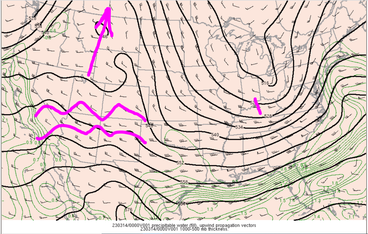
If that meso forms is that a whole new ballgame back to what we were seeing b4? Nowcasting things lost in model runs within 12 hrs nuts.Frank_Wx wrote:500mb overlaid with preciptable water and wind direction. Winds off our coast from the WSW with heavy rain about to move in. The surface low is deepening and heading NNE. Will be interesting to see if we see the meso low try to form. Models lost that feature but you never know during nowcast. Also, such an interesting look at 500mb. Reminds me of a split flow. The ridge looks cut-off.
jmanley32- Senior Enthusiast
- Posts : 20517
Join date : 2013-12-12
Re: March 13th-14th "Agita" Storm Part II
![]() by heehaw453 Mon Mar 13, 2023 9:23 pm
by heehaw453 Mon Mar 13, 2023 9:23 pm

heehaw453- Advanced Forecaster

- Posts : 3906
Reputation : 86
Join date : 2014-01-20
Location : Bedminster Township, PA Elevation 600' ASL
Re: March 13th-14th "Agita" Storm Part II
![]() by aiannone Mon Mar 13, 2023 9:43 pm
by aiannone Mon Mar 13, 2023 9:43 pm
jmanley32 wrote:I am trying to picture how that is oriented and does not impact NYC and immediate suburbs I mean the CCB will be curved no? And going from north to south from NJ to LI, that wouldn't hit NYC? If no at the very least I am trying toi learn how this all works.Frank_Wx wrote:I think the CCB has a real chance to impact the shore and Long Island. Looking forward to 00z data tonight.
Stupid daylight savings pushing back the 00z.
Alex don't get me started on taxes this year is the worst for me, do you do taxes for a living?
yessir, i do haha.
_________________
-Alex Iannone-

aiannone- Senior Enthusiast - Mod

- Posts : 4814
Reputation : 92
Join date : 2013-01-07
Location : Saint James, LI (Northwest Suffolk Co.)
Re: March 13th-14th "Agita" Storm Part II
![]() by jmanley32 Mon Mar 13, 2023 9:51 pm
by jmanley32 Mon Mar 13, 2023 9:51 pm
I may need your services, hit you over in banter.aiannone wrote:jmanley32 wrote:I am trying to picture how that is oriented and does not impact NYC and immediate suburbs I mean the CCB will be curved no? And going from north to south from NJ to LI, that wouldn't hit NYC? If no at the very least I am trying toi learn how this all works.Frank_Wx wrote:I think the CCB has a real chance to impact the shore and Long Island. Looking forward to 00z data tonight.
Stupid daylight savings pushing back the 00z.
Alex don't get me started on taxes this year is the worst for me, do you do taxes for a living?
yessir, i do haha.

jmanley32- Senior Enthusiast
- Posts : 20517
Reputation : 108
Join date : 2013-12-12
Age : 42
Location : Yonkers, NY
Re: March 13th-14th "Agita" Storm Part II
![]() by aiannone Mon Mar 13, 2023 9:56 pm
by aiannone Mon Mar 13, 2023 9:56 pm
jmanley32 wrote:I may need your services, hit you over in banter.aiannone wrote:jmanley32 wrote:I am trying to picture how that is oriented and does not impact NYC and immediate suburbs I mean the CCB will be curved no? And going from north to south from NJ to LI, that wouldn't hit NYC? If no at the very least I am trying toi learn how this all works.Frank_Wx wrote:I think the CCB has a real chance to impact the shore and Long Island. Looking forward to 00z data tonight.
Stupid daylight savings pushing back the 00z.
Alex don't get me started on taxes this year is the worst for me, do you do taxes for a living?
yessir, i do haha.
You got it!
_________________
-Alex Iannone-
aiannone- Senior Enthusiast - Mod
- Posts : 4814
Reputation : 92
Join date : 2013-01-07
Location : Saint James, LI (Northwest Suffolk Co.)
Re: March 13th-14th "Agita" Storm Part II
![]() by 1190ftalt Mon Mar 13, 2023 10:00 pm
by 1190ftalt Mon Mar 13, 2023 10:00 pm


1190ftalt- Pro Enthusiast

- Posts : 397
Reputation : 10
Join date : 2013-12-13
Location : Stillwater, NJ
CPcantmeasuresnow, heehaw453, weatherwatchermom, SENJsnowman and CNWestMilford like this post
Re: March 13th-14th "Agita" Storm Part II
![]() by aiannone Mon Mar 13, 2023 10:04 pm
by aiannone Mon Mar 13, 2023 10:04 pm
1190ftalt wrote:Just started snowing hard, 33 degrees, sticking to cars, time 9:58 in the PM
Earlier than expected?
_________________
-Alex Iannone-
aiannone- Senior Enthusiast - Mod
- Posts : 4814
Reputation : 92
Join date : 2013-01-07
Location : Saint James, LI (Northwest Suffolk Co.)
Re: March 13th-14th "Agita" Storm Part II
![]() by jmanley32 Mon Mar 13, 2023 10:24 pm
by jmanley32 Mon Mar 13, 2023 10:24 pm
jmanley32- Senior Enthusiast
- Posts : 20517
Reputation : 108
Join date : 2013-12-12
Age : 42
Location : Yonkers, NY
Re: March 13th-14th "Agita" Storm Part II
![]() by heehaw453 Mon Mar 13, 2023 10:29 pm
by heehaw453 Mon Mar 13, 2023 10:29 pm


heehaw453- Advanced Forecaster
- Posts : 3906
Reputation : 86
Join date : 2014-01-20
Location : Bedminster Township, PA Elevation 600' ASL
CPcantmeasuresnow likes this post
Re: March 13th-14th "Agita" Storm Part II
![]() by CPcantmeasuresnow Mon Mar 13, 2023 10:30 pm
by CPcantmeasuresnow Mon Mar 13, 2023 10:30 pm
This poor excuse for a storm and I are not on good terms.

CPcantmeasuresnow- Wx Statistician Guru

- Posts : 7274
Reputation : 230
Join date : 2013-01-07
Age : 103
Location : Eastern Orange County, NY
SENJsnowman likes this post
Re: March 13th-14th "Agita" Storm Part II
![]() by heehaw453 Mon Mar 13, 2023 10:33 pm
by heehaw453 Mon Mar 13, 2023 10:33 pm
heehaw453- Advanced Forecaster
- Posts : 3906
Reputation : 86
Join date : 2014-01-20
Location : Bedminster Township, PA Elevation 600' ASL
Re: March 13th-14th "Agita" Storm Part II
![]() by rb924119 Mon Mar 13, 2023 10:41 pm
by rb924119 Mon Mar 13, 2023 10:41 pm
heehaw453 wrote:Look at the Atlantic. That is a massive 50/50. There's no where for the storm to go literally. There's circulation off the Jersey coast and that is the storm in front of the 500mb trough that is interacting with the offshore coastal which is well east of OBX. Confirmed by the 850s on the meso graph. This thing is trying to get its act together.
It already is. Look at the radar and satellite imagery. Radar indicates the closed secondary H850 circulation over interior NJ, which is southwest/earlier than modeled. Secondarily, the satellite imagery is showing a distinct backing of the moister fetch associated with the heavier precipitation. This certainly seems to be much earlier than modeling suggested, and suggests to me that it bodes well for my ideas. That flow should continue to back as the whole system matures, and as it does, draw that moisture feed with it into the increasingly ascending air. For the areas in NW NJ, NEPA, and the Catskill region, this is exactly what we want to see.
rb924119- Meteorologist

- Posts : 6890
Reputation : 194
Join date : 2013-02-06
Age : 32
Location : Greentown, Pa
1190ftalt, heehaw453 and phil155 like this post
Re: March 13th-14th "Agita" Storm Part II
![]() by aiannone Mon Mar 13, 2023 10:43 pm
by aiannone Mon Mar 13, 2023 10:43 pm
rb924119 wrote:heehaw453 wrote:Look at the Atlantic. That is a massive 50/50. There's no where for the storm to go literally. There's circulation off the Jersey coast and that is the storm in front of the 500mb trough that is interacting with the offshore coastal which is well east of OBX. Confirmed by the 850s on the meso graph. This thing is trying to get its act together.
It already is. Look at the radar and satellite imagery. Radar indicates the closed secondary H850 circulation over interior NJ, which is southwest/earlier than modeled. Secondarily, the satellite imagery is showing a distinct backing of the moister fetch associated with the heavier precipitation. This certainly seems to be much earlier than modeling suggested, and suggests to me that it bodes well for my ideas. That flow should continue to back as the whole system matures, and as it does, draw that moisture feed with it into the increasingly ascending air. For the areas in NW NJ, NEPA, and the Catskill region, this is exactly what we want to see.
Ray, any meaning for LI?
_________________
-Alex Iannone-
aiannone- Senior Enthusiast - Mod
- Posts : 4814
Reputation : 92
Join date : 2013-01-07
Location : Saint James, LI (Northwest Suffolk Co.)
Re: March 13th-14th "Agita" Storm Part II
![]() by CPcantmeasuresnow Mon Mar 13, 2023 10:44 pm
by CPcantmeasuresnow Mon Mar 13, 2023 10:44 pm
heehaw453 wrote:If this had the right conditions it would have rivaled all time blizzards this area has ever seen. The biggest issue was lack of cold air. Had we had good CAD and that ULL was backed by arctic air Blizzard of 1888 type of thing.
Et tu Brute?
CPcantmeasuresnow- Wx Statistician Guru
- Posts : 7274
Reputation : 230
Join date : 2013-01-07
Age : 103
Location : Eastern Orange County, NY
Re: March 13th-14th "Agita" Storm Part II
![]() by rb924119 Mon Mar 13, 2023 10:45 pm
by rb924119 Mon Mar 13, 2023 10:45 pm
rb924119 wrote:Playing contrarian here, we should start to see the radar fill in now. The red line looks to me to be the back edge associated with the backing mid-level flows (H7 and H5). The yellow line is my estimation of the back edge of the precipitation being forced by the lower-levels H85 and below). The blue line is the back edge that I’m expecting to see emerge over the next several hours. Then as the whole system progresses, some northward progression of the back edge is expected, but it should pivot more than just lift up/out. Will be fun to test this.
I’m not giving up on this. If I’m wrong then so be it. But right now, I like what I’m seeing on radar and satellite imagery.

For comparison. I think so far, things are on track, especially since we are now clearly pivoting based on radar/satellite imagery.
Current radar:

rb924119- Meteorologist
- Posts : 6890
Reputation : 194
Join date : 2013-02-06
Age : 32
Location : Greentown, Pa
Re: March 13th-14th "Agita" Storm Part II
![]() by rb924119 Mon Mar 13, 2023 10:51 pm
by rb924119 Mon Mar 13, 2023 10:51 pm
aiannone wrote:rb924119 wrote:heehaw453 wrote:Look at the Atlantic. That is a massive 50/50. There's no where for the storm to go literally. There's circulation off the Jersey coast and that is the storm in front of the 500mb trough that is interacting with the offshore coastal which is well east of OBX. Confirmed by the 850s on the meso graph. This thing is trying to get its act together.
It already is. Look at the radar and satellite imagery. Radar indicates the closed secondary H850 circulation over interior NJ, which is southwest/earlier than modeled. Secondarily, the satellite imagery is showing a distinct backing of the moister fetch associated with the heavier precipitation. This certainly seems to be much earlier than modeling suggested, and suggests to me that it bodes well for my ideas. That flow should continue to back as the whole system matures, and as it does, draw that moisture feed with it into the increasingly ascending air. For the areas in NW NJ, NEPA, and the Catskill region, this is exactly what we want to see.
Ray, any meaning for LI?
Well, out front it’ll delay any changeover. But a more mature cyclone will likely help backside banding/cold advection once it moves by. Sort of a “famine now, feast later” type of deal assuming the rest of the evolution follows a logical progression.
rb924119- Meteorologist
- Posts : 6890
Reputation : 194
Join date : 2013-02-06
Age : 32
Location : Greentown, Pa
Re: March 13th-14th "Agita" Storm Part II
![]() by heehaw453 Mon Mar 13, 2023 10:51 pm
by heehaw453 Mon Mar 13, 2023 10:51 pm

heehaw453- Advanced Forecaster
- Posts : 3906
Reputation : 86
Join date : 2014-01-20
Location : Bedminster Township, PA Elevation 600' ASL
Re: March 13th-14th "Agita" Storm Part II
![]() by aiannone Mon Mar 13, 2023 10:56 pm
by aiannone Mon Mar 13, 2023 10:56 pm
rb924119 wrote:aiannone wrote:rb924119 wrote:heehaw453 wrote:Look at the Atlantic. That is a massive 50/50. There's no where for the storm to go literally. There's circulation off the Jersey coast and that is the storm in front of the 500mb trough that is interacting with the offshore coastal which is well east of OBX. Confirmed by the 850s on the meso graph. This thing is trying to get its act together.
It already is. Look at the radar and satellite imagery. Radar indicates the closed secondary H850 circulation over interior NJ, which is southwest/earlier than modeled. Secondarily, the satellite imagery is showing a distinct backing of the moister fetch associated with the heavier precipitation. This certainly seems to be much earlier than modeling suggested, and suggests to me that it bodes well for my ideas. That flow should continue to back as the whole system matures, and as it does, draw that moisture feed with it into the increasingly ascending air. For the areas in NW NJ, NEPA, and the Catskill region, this is exactly what we want to see.
Ray, any meaning for LI?
Well, out front it’ll delay any changeover. But a more mature cyclone will likely help backside banding/cold advection once it moves by. Sort of a “famine now, feast later” type of deal assuming the rest of the evolution follows a logical progression.
Gotcha. 3k nam hinting at a backend thump over the island. Been consistent with that. Hoping it will be the case
_________________
-Alex Iannone-
aiannone- Senior Enthusiast - Mod
- Posts : 4814
Reputation : 92
Join date : 2013-01-07
Location : Saint James, LI (Northwest Suffolk Co.)
rb924119 likes this post
Re: March 13th-14th "Agita" Storm Part II
![]() by CPcantmeasuresnow Mon Mar 13, 2023 10:58 pm
by CPcantmeasuresnow Mon Mar 13, 2023 10:58 pm
Keep up the good work Heehaw and RB. Glad to have you back.
CPcantmeasuresnow- Wx Statistician Guru
- Posts : 7274
Reputation : 230
Join date : 2013-01-07
Age : 103
Location : Eastern Orange County, NY
docstox12, rb924119, essexcountypete and heehaw453 like this post
Re: March 13th-14th "Agita" Storm Part II
![]() by rb924119 Mon Mar 13, 2023 10:59 pm
by rb924119 Mon Mar 13, 2023 10:59 pm
heehaw453 wrote:rb trough seems to be tilting.
This imagery agrees, and is what I’ve been using to assess progression:
http://www.meteo.psu.edu/ewall/PSUGOES_US/loop60i.html
You can clearly see the whole trough laying back now. Don’t forget, that meso page is an hour behind. But still, seeing the actual fluidity in motion really helps to determine how things are behaving.
rb924119- Meteorologist
- Posts : 6890
Reputation : 194
Join date : 2013-02-06
Age : 32
Location : Greentown, Pa
Re: March 13th-14th "Agita" Storm Part II
![]() by rb924119 Mon Mar 13, 2023 11:04 pm
by rb924119 Mon Mar 13, 2023 11:04 pm
rb924119 wrote:heehaw453 wrote:rb trough seems to be tilting.
This imagery agrees, and is what I’ve been using to assess progression:
http://www.meteo.psu.edu/ewall/PSUGOES_US/loop60i.html
You can clearly see the whole trough laying back now. Don’t forget, that meso page is an hour behind. But still, seeing the actual fluidity in motion really helps to determine how things are behaving.
You can also see the colder cloud tops rebuilding and angling back over central PA. This is in response to the vorticity advection catching up to the H7 frontogenesis. We should start to see some radar returns filling in there soon. But, as those forcing mechanisms continue to shift east, they should begin to draw the ascending air from the H850 frontogenesis into them, and once that starts happening, then that’s when things should start to pick up on earnest. And based on what I’m seeing, it won’t be at Albany’s latitude.
rb924119- Meteorologist
- Posts : 6890
Reputation : 194
Join date : 2013-02-06
Age : 32
Location : Greentown, Pa
heehaw453 likes this post
Re: March 13th-14th "Agita" Storm Part II
![]() by CNWestMilford Mon Mar 13, 2023 11:09 pm
by CNWestMilford Mon Mar 13, 2023 11:09 pm

CNWestMilford- Posts : 43
Reputation : 1
Join date : 2020-12-15
Age : 47
Location : West Milford
1190ftalt and weatherwatchermom like this post
Re: March 13th-14th "Agita" Storm Part II
![]() by hyde345 Mon Mar 13, 2023 11:09 pm
by hyde345 Mon Mar 13, 2023 11:09 pm

hyde345- Pro Enthusiast
- Posts : 1082
Reputation : 48
Join date : 2013-01-08
Location : Hyde Park, NY
1190ftalt and weatherwatchermom like this post
Re: March 13th-14th "Agita" Storm Part II
![]() by rb924119 Mon Mar 13, 2023 11:12 pm
by rb924119 Mon Mar 13, 2023 11:12 pm
rb924119 wrote:rb924119 wrote:heehaw453 wrote:rb trough seems to be tilting.
This imagery agrees, and is what I’ve been using to assess progression:
http://www.meteo.psu.edu/ewall/PSUGOES_US/loop60i.html
You can clearly see the whole trough laying back now. Don’t forget, that meso page is an hour behind. But still, seeing the actual fluidity in motion really helps to determine how things are behaving.
You can also see the colder cloud tops rebuilding and angling back over central PA. This is in response to the vorticity advection catching up to the H7 frontogenesis. We should start to see some radar returns filling in there soon. But, as those forcing mechanisms continue to shift east, they should begin to draw the ascending air from the H850 frontogenesis into them, and once that starts happening, then that’s when things should start to pick up on earnest. And based on what I’m seeing, it won’t be at Albany’s latitude.
Note the latitude of the comma head associated with the H5 circulation relative to our backing moisture feed, denoted by the red line. The yellow line represents the expected H5 track (center of vorticity). Anywhere north of that vort axis should capitalize once these forcings come together, in my opinion (A.K.A. along and north of my red line lol).

rb924119- Meteorologist
- Posts : 6890
Reputation : 194
Join date : 2013-02-06
Age : 32
Location : Greentown, Pa
heehaw453 likes this post
Re: March 13th-14th "Agita" Storm Part II
![]() by rb924119 Mon Mar 13, 2023 11:14 pm
by rb924119 Mon Mar 13, 2023 11:14 pm
CPcantmeasuresnow wrote:33.8 and mostly snow now here. A little earlier then expected. I’m not getting my hopes up though.
Keep up the good work Heehaw and RB. Glad to have you back.
Thanks, CP, it’s good to be back!! I just hope that I can reel ‘er in for us!! I’m trying like heck, that’s for sure haha
rb924119- Meteorologist
- Posts : 6890
Reputation : 194
Join date : 2013-02-06
Age : 32
Location : Greentown, Pa
CPcantmeasuresnow, hyde345 and 1190ftalt like this post
Re: March 13th-14th "Agita" Storm Part II
![]() by heehaw453 Mon Mar 13, 2023 11:21 pm
by heehaw453 Mon Mar 13, 2023 11:21 pm
Makes sense with an ULL track like that. Probably even MBY in northern most bucks may get a taste.rb924119 wrote:rb924119 wrote:rb924119 wrote:heehaw453 wrote:rb trough seems to be tilting.
This imagery agrees, and is what I’ve been using to assess progression:
http://www.meteo.psu.edu/ewall/PSUGOES_US/loop60i.html
You can clearly see the whole trough laying back now. Don’t forget, that meso page is an hour behind. But still, seeing the actual fluidity in motion really helps to determine how things are behaving.
You can also see the colder cloud tops rebuilding and angling back over central PA. This is in response to the vorticity advection catching up to the H7 frontogenesis. We should start to see some radar returns filling in there soon. But, as those forcing mechanisms continue to shift east, they should begin to draw the ascending air from the H850 frontogenesis into them, and once that starts happening, then that’s when things should start to pick up on earnest. And based on what I’m seeing, it won’t be at Albany’s latitude.
Note the latitude of the comma head associated with the H5 circulation relative to our backing moisture feed, denoted by the red line. The yellow line represents the expected H5 track (center of vorticity). Anywhere north of that vort axis should capitalize once these forcings come together, in my opinion (A.K.A. along and north of my red line lol).
heehaw453- Advanced Forecaster
- Posts : 3906
Reputation : 86
Join date : 2014-01-20
Location : Bedminster Township, PA Elevation 600' ASL
Page 8 of 15 • 1 ... 5 ... 7, 8, 9 ... 11 ... 15 ![]()
|
|
|