
 Search
2023 Atlantic Tropics season
Page 2 of 20 •  1, 2, 3 ... 11 ... 20
 ![]()
Re: 2023 Atlantic Tropics season
![]() by GreyBeard Sun Aug 13, 2023 1:22 pm
by GreyBeard Sun Aug 13, 2023 1:22 pm
GreyBeard- Senior Enthusiast

- Posts : 725
Join date : 2014-02-12
sroc4, docstox12, rb924119 and SENJsnowman like this post
Re: 2023 Atlantic Tropics season
![]() by rb924119 Sun Aug 13, 2023 8:35 pm
by rb924119 Sun Aug 13, 2023 8:35 pm
sroc4 wrote:Great Minds Ray....
I like yours better, though lol
rb924119- Meteorologist

- Posts : 6890
Join date : 2013-02-06
sroc4 likes this post
Re: 2023 Atlantic Tropics season
![]() by rb924119 Sun Aug 13, 2023 8:37 pm
by rb924119 Sun Aug 13, 2023 8:37 pm
GreyBeard wrote:Ray and Scott, thanks for your in depth discussion and explanation. You have certainly helped me better understand some of the dynamics that occur during a hurricane. Both of you are very generous with your time and knowledge, and your willingness to share that is certainly appreciated. You both have obviously taken a good amount of time out of your day to do so. Scott, if I might make a suggestion, perhaps save the posts you both have offered to the weather education thread so they might be preserved and available for all to see long after this tropical season passes. Thanks again guys.
This is EXACTLY the point of this place, and is what brought us all here; interest, and interest to learn
rb924119- Meteorologist
- Posts : 6890
Reputation : 194
Join date : 2013-02-06
Age : 32
Location : Greentown, Pa
sroc4 likes this post
Re: 2023 Atlantic Tropics season
![]() by sroc4 Thu Aug 17, 2023 8:15 am
by sroc4 Thu Aug 17, 2023 8:15 am
Here is the current 7day forecast. There are two areas with a 60% chance to develop into a tropical cyclone and one in the GOM with only a 20% chance.

The old saying "If a tree in the woods falls when no one is around, does it make a sound?" comes to mind. In todays modern satellite era it becomes very easy to classify some of these systems that develop way out in no mans land, and harmlessly recurve and lose trop cyclone status within a day or two.
IF we end up with a normal to slight above normal season(which I do not think happens) as was most recently noted, is it because we have way more microphones placed to hear the trees falling when compared to 25, 50 , and 100+ years of recorded history? When you look at the intensity, track duration, and where they formed of the 4 named storms so far this year, (Arlene, Bret, Cindy and Don) one has to really wonder if they would have been named at all if we were living 50-100yrs ago when you look at where they developed, and how long(or short) they maintained Trop cyclone status.
It will be important to keep this in mind when the "in your face headlines pushing certain narratives" come at us come October and November as the season winds down, again if we end up with "above normal" named systems.
_________________
"In weather and in life, there's no winning and losing; there's only winning and learning."
WINTER 2012/2013 TOTALS 43.65"WINTER 2017/2018 TOTALS 62.85" WINTER 2022/2023 TOTALS 4.9"
WINTER 2013/2014 TOTALS 64.85"WINTER 2018/2019 TOTALS 14.25" WINTER 2023/2024 TOTALS 13.1"
WINTER 2014/2015 TOTALS 71.20"WINTER 2019/2020 TOTALS 6.35"
WINTER 2015/2016 TOTALS 35.00"WINTER 2020/2021 TOTALS 37.75"
WINTER 2016/2017 TOTALS 42.25"WINTER 2021/2022 TOTALS 31.65"

sroc4- Admin

- Posts : 8331
Reputation : 301
Join date : 2013-01-07
Location : Wading River, LI
billg315 likes this post
Re: 2023 Atlantic Tropics season
![]() by jmanley32 Thu Aug 17, 2023 9:18 am
by jmanley32 Thu Aug 17, 2023 9:18 am

jmanley32- Senior Enthusiast
- Posts : 20516
Reputation : 108
Join date : 2013-12-12
Age : 42
Location : Yonkers, NY
Re: 2023 Atlantic Tropics season
![]() by jmanley32 Thu Aug 17, 2023 9:20 am
by jmanley32 Thu Aug 17, 2023 9:20 am
I blame Sandy, that's when they started classifying and naming everything that appeared even somewhat tropical, it was meant to save face from Sandy's destruction and IMO is okay in one way and not in others.sroc4 wrote:With the latest forecasts for a slight above normal activity I stop and wonder sometimes.
Here is the current 7day forecast. There are two areas with a 60% chance to develop into a tropical cyclone and one in the GOM with only a 20% chance.
The old saying "If a tree in the woods falls when no one is around, does it make a sound?" comes to mind. In todays modern satellite era it becomes very easy to classify some of these systems that develop way out in no mans land, and harmlessly recurve and lose trop cyclone status within a day or two.
IF we end up with a normal to slight above normal season(which I do not think happens) as was most recently noted, is it because we have way more microphones placed to hear the trees falling when compared to 25, 50 , and 100+ years of recorded history? When you look at the intensity, track duration, and where they formed of the 4 named storms so far this year, (Arlene, Bret, Cindy and Don) one has to really wonder if they would have been named at all if we were living 50-100yrs ago when you look at where they developed, and how long(or short) they maintained Trop cyclone status.
It will be important to keep this in mind when the "in your face headlines pushing certain narratives" come at us come October and November as the season winds down, again if we end up with "above normal" named systems.
jmanley32- Senior Enthusiast
- Posts : 20516
Reputation : 108
Join date : 2013-12-12
Age : 42
Location : Yonkers, NY
sroc4 likes this post
Re: 2023 Atlantic Tropics season
![]() by docstox12 Fri Aug 18, 2023 6:25 am
by docstox12 Fri Aug 18, 2023 6:25 am
sroc4 wrote:With the latest forecasts for a slight above normal activity I stop and wonder sometimes.
Here is the current 7day forecast. There are two areas with a 60% chance to develop into a tropical cyclone and one in the GOM with only a 20% chance.
The old saying "If a tree in the woods falls when no one is around, does it make a sound?" comes to mind. In todays modern satellite era it becomes very easy to classify some of these systems that develop way out in no mans land, and harmlessly recurve and lose trop cyclone status within a day or two.
IF we end up with a normal to slight above normal season(which I do not think happens) as was most recently noted, is it because we have way more microphones placed to hear the trees falling when compared to 25, 50 , and 100+ years of recorded history? When you look at the intensity, track duration, and where they formed of the 4 named storms so far this year, (Arlene, Bret, Cindy and Don) one has to really wonder if they would have been named at all if we were living 50-100yrs ago when you look at where they developed, and how long(or short) they maintained Trop cyclone status.
It will be important to keep this in mind when the "in your face headlines pushing certain narratives" come at us come October and November as the season winds down, again if we end up with "above normal" named systems.
It has come a long way from almost 100 years ago.Today, if a disturbance is ten feet off the African coast, it is picked up.The huge hurricane of 1935 that destroyed the railway connection to Key West came up very fast.I read a report that the morning in Key West was sunny and calm but by late afternoon, all hell broke loose.A train of railway workers was lost when the surge came up very fast.They were still finding bodies from this storm ten years later.Same with the 1938 hurricane that hit Long Island.Over 700 dead with the massive storm surge.I think it's much better today to closely monitor these things and get people evacuated before there is loss of life like those 1930's storms.

docstox12- Wx Statistician Guru

- Posts : 8504
Reputation : 222
Join date : 2013-01-07
Age : 73
Location : Monroe NY
weatherwatchermom likes this post
Re: 2023 Atlantic Tropics season
![]() by sroc4 Fri Aug 18, 2023 7:37 am
by sroc4 Fri Aug 18, 2023 7:37 am
Well when looking at the daily values of the SOI perhaps there are clues. In general values consistently less than -8 are consistent with El Nino atmospheric conditions; whereas, values above +8 La Nina, and values in between La Nada(neutral ENSO).
https://www.longpaddock.qld.gov.au/soi/
You can clearly see that for the first time over the past week, between August 11th and this am, the daily values have come way up from there deep negative state(which is constant with the mod El Nino), and into a nutral state over about a 1 week period. The 30 and 90 avg SOI; however, remains in the negative El Nino state.
Just a reminder the SOI is a numerical value that describes the general pressure pattern between Darwin Australia and Tahiti which more broadly can give us an idea of the general pattern of upward vs downward motion to the walker cell configuration discussed in my post a few days ago.
So perhaps the week long change to the pressure pattern on the pacific side more towards neutral conditions has sort of lifted the cap that has been preventing upward motion in the Atlantics MDR, perhaps temporarily, such that since we are approaching peak season we are seeing multiple tropical waves with the potential to develop further. It will be interesting to see how these current waves on the map above behaves if the SOI goes back strong negative again, perhaps stamping out any major development vs sustaining/maintaining its current neutral look vs goes even more positive.
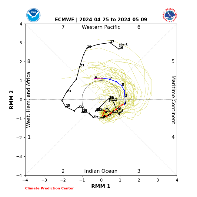
FWIW the MJO, also an indicator of where rising and sinking air is along the tropical pacific side of things, has been stuck in neutral most oif the summer so it doesnt appear it has had any major influence on the big picture.
_________________
"In weather and in life, there's no winning and losing; there's only winning and learning."
WINTER 2012/2013 TOTALS 43.65"WINTER 2017/2018 TOTALS 62.85" WINTER 2022/2023 TOTALS 4.9"
WINTER 2013/2014 TOTALS 64.85"WINTER 2018/2019 TOTALS 14.25" WINTER 2023/2024 TOTALS 13.1"
WINTER 2014/2015 TOTALS 71.20"WINTER 2019/2020 TOTALS 6.35"
WINTER 2015/2016 TOTALS 35.00"WINTER 2020/2021 TOTALS 37.75"
WINTER 2016/2017 TOTALS 42.25"WINTER 2021/2022 TOTALS 31.65"
sroc4- Admin
- Posts : 8331
Reputation : 301
Join date : 2013-01-07
Location : Wading River, LI
rb924119 and weatherwatchermom like this post
Re: 2023 Atlantic Tropics season
![]() by rb924119 Fri Aug 18, 2023 4:41 pm
by rb924119 Fri Aug 18, 2023 4:41 pm
sroc4 wrote:If you look at the image below we see its has become very active fairly rapidly. Why? Atlantic temps have been warm throughout and we have had a steady oncoming of the El Nino which we have discussed above tends to favor sinking air over the Atlantic's Main developmental regions(MDR). So again...why now??
Well when looking at the daily values of the SOI perhaps there are clues. In general values consistently less than -8 are consistent with El Nino atmospheric conditions; whereas, values above +8 La Nina, and values in between La Nada(neutral ENSO).
https://www.longpaddock.qld.gov.au/soi/
You can clearly see that for the first time over the past week, between August 11th and this am, the daily values have come way up from there deep negative state(which is constant with the mod El Nino), and into a nutral state over about a 1 week period. The 30 and 90 avg SOI; however, remains in the negative El Nino state.
Just a reminder the SOI is a numerical value that describes the general pressure pattern between Darwin Australia and Tahiti which more broadly can give us an idea of the general pattern of upward vs downward motion to the walker cell configuration discussed in my post a few days ago.
So perhaps the week long change to the pressure pattern on the pacific side more towards neutral conditions has sort of lifted the cap that has been preventing upward motion in the Atlantics MDR, perhaps temporarily, such that since we are approaching peak season we are seeing multiple tropical waves with the potential to develop further. It will be interesting to see how these current waves on the map above behaves if the SOI goes back strong negative again, perhaps stamping out any major development vs sustaining/maintaining its current neutral look vs goes even more positive.
FWIW the MJO, also an indicator of where rising and sinking air is along the tropical pacific side of things, has been stuck in neutral most oif the summer so it doesnt appear it has had any major influence on the big picture.
Great post, as usual, Scott!
As some further supporting evidence, here’s a look at the 200hPa velocity potential (a measurement of convergence aloft). Negative values indicate divergence, or large-scale ascent, positives indicate convergence, or large-scale sinking. Time is the vertical axis, longitude is the horizontal axis. You can see that the large-scale ascent is located over the Caribbean and tropical Atlantic based on the longitudes, which is perfectly in line with Scott’s discussion.

rb924119- Meteorologist
- Posts : 6890
Reputation : 194
Join date : 2013-02-06
Age : 32
Location : Greentown, Pa
sroc4 likes this post
Re: 2023 Atlantic Tropics season
![]() by rb924119 Fri Aug 18, 2023 4:45 pm
by rb924119 Fri Aug 18, 2023 4:45 pm
rb924119- Meteorologist
- Posts : 6890
Reputation : 194
Join date : 2013-02-06
Age : 32
Location : Greentown, Pa
Re: 2023 Atlantic Tropics season
![]() by jmanley32 Sun Aug 20, 2023 11:30 pm
by jmanley32 Sun Aug 20, 2023 11:30 pm
Would that be wit Franklin? I see the GFS has him recurve back towards the US, and I think 12z today had him as a large subtropical hitting nova scotia, not far off from a NE or even further south hit, if thats what ur talking about. Where do you see Euro past day 10? I no longer have any sub.rb924119 wrote:For what it’s worth, the Euro Ensemble raised my eyebrows for some tropical mischief up here beyond day 10, but it requires a deep dive which I do not currently have time for lol I’ll take a look at some point, though haha
How is no one talking about the fact that southern CA is having a TS, with catastropic flooding and las vegas is in for big problems..
jmanley32- Senior Enthusiast
- Posts : 20516
Reputation : 108
Join date : 2013-12-12
Age : 42
Location : Yonkers, NY
Re: 2023 Atlantic Tropics season
![]() by sroc4 Mon Aug 21, 2023 8:00 am
by sroc4 Mon Aug 21, 2023 8:00 am
jmanley32 wrote:Would that be wit Franklin? I see the GFS has him recurve back towards the US, and I think 12z today had him as a large subtropical hitting nova scotia, not far off from a NE or even further south hit, if thats what ur talking about. Where do you see Euro past day 10? I no longer have any sub.rb924119 wrote:For what it’s worth, the Euro Ensemble raised my eyebrows for some tropical mischief up here beyond day 10, but it requires a deep dive which I do not currently have time for lol I’ll take a look at some point, though haha
How is no one talking about the fact that southern CA is having a TS, with catastrophic flooding and las Vegas is in for big problems..
Lets not get ahead of ourselves Jon. Don't take any model beyond day 3 with these tropics. There is still huge amounts of uncertainty at day 3. And regarding What Ray said, while I don't want to put words in his mouth, I believe it was more of a pattern recognition comment rather than any one particular system being the one. As of now Franklin is the only one on the table that has any potential, but again dont believe anything before it crosses Hispaniola/DR. Where is crosses, timing, how strong, and what the mountains do to it are still uncertain and that's less than 3 days away. Once it begins to lift north then we start looking at the 500mb pattern to see IF it even has a chance of retrograding back towards the coast. You need a mechanism for that to happen. Ie: northern Atlantic blocking, or an upper level low that cuts off along the EC and retrogrades SW combined with a N Atlantic Blocking feature. As of now the pattern looks to keep a trough in the NE and along the EC to some capacity which would favor a recurve, at least for Franklin.
Personally It wouldn't surprise me if a wave currently not yet designated coming out of the Caribbean has the best shot at affecting the EC in the next 7-14D time frame.
_________________
"In weather and in life, there's no winning and losing; there's only winning and learning."
WINTER 2012/2013 TOTALS 43.65"WINTER 2017/2018 TOTALS 62.85" WINTER 2022/2023 TOTALS 4.9"
WINTER 2013/2014 TOTALS 64.85"WINTER 2018/2019 TOTALS 14.25" WINTER 2023/2024 TOTALS 13.1"
WINTER 2014/2015 TOTALS 71.20"WINTER 2019/2020 TOTALS 6.35"
WINTER 2015/2016 TOTALS 35.00"WINTER 2020/2021 TOTALS 37.75"
WINTER 2016/2017 TOTALS 42.25"WINTER 2021/2022 TOTALS 31.65"
sroc4- Admin
- Posts : 8331
Reputation : 301
Join date : 2013-01-07
Location : Wading River, LI
Re: 2023 Atlantic Tropics season
![]() by jmanley32 Mon Aug 21, 2023 6:41 pm
by jmanley32 Mon Aug 21, 2023 6:41 pm
No offense but you don't think I don't know all this by now? It was just a question, not jumping the gun on anything, in fact been so busy did not even know the tropics were lit or that southern CA got hit with a TS (though it was forecasted but bizarre either way). A retrograde is super unlikely but it can happen, and yes even though I like looking at fantasy land model runs it holds no ground.sroc4 wrote:jmanley32 wrote:Would that be wit Franklin? I see the GFS has him recurve back towards the US, and I think 12z today had him as a large subtropical hitting nova scotia, not far off from a NE or even further south hit, if thats what ur talking about. Where do you see Euro past day 10? I no longer have any sub.rb924119 wrote:For what it’s worth, the Euro Ensemble raised my eyebrows for some tropical mischief up here beyond day 10, but it requires a deep dive which I do not currently have time for lol I’ll take a look at some point, though haha
How is no one talking about the fact that southern CA is having a TS, with catastrophic flooding and las Vegas is in for big problems..
Lets not get ahead of ourselves Jon. Don't take any model beyond day 3 with these tropics. There is still huge amounts of uncertainty at day 3. And regarding What Ray said, while I don't want to put words in his mouth, I believe it was more of a pattern recognition comment rather than any one particular system being the one. As of now Franklin is the only one on the table that has any potential, but again dont believe anything before it crosses Hispaniola/DR. Where is crosses, timing, how strong, and what the mountains do to it are still uncertain and that's less than 3 days away. Once it begins to lift north then we start looking at the 500mb pattern to see IF it even has a chance of retrograding back towards the coast. You need a mechanism for that to happen. Ie: northern Atlantic blocking, or an upper level low that cuts off along the EC and retrogrades SW combined with a N Atlantic Blocking feature. As of now the pattern looks to keep a trough in the NE and along the EC to some capacity which would favor a recurve, at least for Franklin.
Personally It wouldn't surprise me if a wave currently not yet designated coming out of the Caribbean has the best shot at affecting the EC in the next 7-14D time frame.
jmanley32- Senior Enthusiast
- Posts : 20516
Reputation : 108
Join date : 2013-12-12
Age : 42
Location : Yonkers, NY
Re: 2023 Atlantic Tropics season
![]() by sroc4 Tue Aug 22, 2023 7:34 am
by sroc4 Tue Aug 22, 2023 7:34 am
jmanley32 wrote:No offense but you don't think I don't know all this by now? It was just a question, not jumping the gun on anything, in fact been so busy did not even know the tropics were lit or that southern CA got hit with a TS (though it was forecasted but bizarre either way). A retrograde is super unlikely but it can happen, and yes even though I like looking at fantasy land model runs it holds no ground.sroc4 wrote:jmanley32 wrote:Would that be wit Franklin? I see the GFS has him recurve back towards the US, and I think 12z today had him as a large subtropical hitting nova scotia, not far off from a NE or even further south hit, if that's what you're talking about. Where do you see Euro past day 10? I no longer have any sub.rb924119 wrote:For what it’s worth, the Euro Ensemble raised my eyebrows for some tropical mischief up here beyond day 10, but it requires a deep dive which I do not currently have time for lol I’ll take a look at some point, though haha
How is no one talking about the fact that southern CA is having a TS, with catastrophic flooding and las Vegas is in for big problems..
Lets not get ahead of ourselves Jon. Don't take any model beyond day 3 with these tropics. There is still huge amounts of uncertainty at day 3. And regarding What Ray said, while I don't want to put words in his mouth, I believe it was more of a pattern recognition comment rather than any one particular system being the one. As of now Franklin is the only one on the table that has any potential, but again don't believe anything before it crosses Hispaniola/DR. Where is crosses, timing, how strong, and what the mountains do to it are still uncertain and that's less than 3 days away. Once it begins to lift north then we start looking at the 500mb pattern to see IF it even has a chance of retrograding back towards the coast. You need a mechanism for that to happen. Ie: northern Atlantic blocking, or an upper level low that cuts off along the EC and retrogrades SW combined with a N Atlantic Blocking feature. As of now the pattern looks to keep a trough in the NE and along the EC to some capacity which would favor a recurve, at least for Franklin.
Personally It wouldn't surprise me if a wave currently not yet designated coming out of the Caribbean has the best shot at affecting the EC in the next 7-14D time frame.
No offense taken Jon. And I hope you don't take offense either when I say it wouldn't be unprecedented for you to perhaps get a tad overzealous in some of your line of questioning and comments regarding potential tropical and/or winter storm potential that are showing up in the long range modeling; the types of questions and comments that I would have thought you would have known by now. That said perhaps after re-reading your original questions my wording was perhaps a bit reactionary. My apologies.
None the less the tropics are still not very exciting despite the active nature. Yes Franklin will cause heavy rains to the DR/Hisp, and similar to Harold in S Tx, but other than that meh. The features in the Western Trop Atlantic have been somewhat down graded in their potential for development. Perhaps that due to the SOI index going back into negative. Thank you btw for whomever contacted the Aussie Govnmnt for me. Looks like the daily SOI is current again.
 There is still a chance that Franklin could affect Bermuda after he heads N of the Greater Antilles; beyond that is mere speculation and fantasy land. I also still think a system coming out of the area I have circled in black is an area to watch for the US in the longer range(7-14days). Euro last night hints at it. GFS has been hinting at it as well.
_________________
"In weather and in life, there's no winning and losing; there's only winning and learning."
WINTER 2012/2013 TOTALS 43.65"WINTER 2017/2018 TOTALS 62.85" WINTER 2022/2023 TOTALS 4.9"
WINTER 2013/2014 TOTALS 64.85"WINTER 2018/2019 TOTALS 14.25" WINTER 2023/2024 TOTALS 13.1"
WINTER 2014/2015 TOTALS 71.20"WINTER 2019/2020 TOTALS 6.35"
WINTER 2015/2016 TOTALS 35.00"WINTER 2020/2021 TOTALS 37.75"
WINTER 2016/2017 TOTALS 42.25"WINTER 2021/2022 TOTALS 31.65"
sroc4- Admin
- Posts : 8331
Reputation : 301
Join date : 2013-01-07
Location : Wading River, LI
Re: 2023 Atlantic Tropics season
![]() by jmanley32 Wed Aug 23, 2023 5:22 am
by jmanley32 Wed Aug 23, 2023 5:22 am
Many years of Jons over zeleous reactions can leave a mark eh? If your experiencing PTSD my hour discounted rate for self-pay is $75 for a 45 min session. Though that a may be a conflict of interest being that I was the one that caused it lol. See there I picked on myself, it is possible. But think about this past winter, if I did get excited it was far less (wasn't much to get excited about we hardly had any snow, one storm if I remember correctly). Why? Because I really have started focusing on more important things (I am really dedicated to my job and it takes up a huge amount of my time but I enjoy it though it can be crazy stressful at times. Have you seen me posting much this year, no not really. So while I still love the weather and get excited when something is on the brink or is happening (that's when I act like a kid in a candy shop haha) I really don't let the LR (or even look at model runs at all) get me excited anymore (I just happened to look at model runs on Monday when I asked). Yeah my question was meerly a question with no excitement attached to it. And yes not much going on, it is yawn. Next 2 months should be interesting to watch, or not, we shall see. isn't that area most coming in late Sept. Oct. I think thats where Sandy originated from which was October as we all know.sroc4 wrote:jmanley32 wrote:No offense but you don't think I don't know all this by now? It was just a question, not jumping the gun on anything, in fact been so busy did not even know the tropics were lit or that southern CA got hit with a TS (though it was forecasted but bizarre either way). A retrograde is super unlikely but it can happen, and yes even though I like looking at fantasy land model runs it holds no ground.sroc4 wrote:jmanley32 wrote:Would that be wit Franklin? I see the GFS has him recurve back towards the US, and I think 12z today had him as a large subtropical hitting nova scotia, not far off from a NE or even further south hit, if that's what you're talking about. Where do you see Euro past day 10? I no longer have any sub.rb924119 wrote:For what it’s worth, the Euro Ensemble raised my eyebrows for some tropical mischief up here beyond day 10, but it requires a deep dive which I do not currently have time for lol I’ll take a look at some point, though haha
How is no one talking about the fact that southern CA is having a TS, with catastrophic flooding and las Vegas is in for big problems..
Lets not get ahead of ourselves Jon. Don't take any model beyond day 3 with these tropics. There is still huge amounts of uncertainty at day 3. And regarding What Ray said, while I don't want to put words in his mouth, I believe it was more of a pattern recognition comment rather than any one particular system being the one. As of now Franklin is the only one on the table that has any potential, but again don't believe anything before it crosses Hispaniola/DR. Where is crosses, timing, how strong, and what the mountains do to it are still uncertain and that's less than 3 days away. Once it begins to lift north then we start looking at the 500mb pattern to see IF it even has a chance of retrograding back towards the coast. You need a mechanism for that to happen. Ie: northern Atlantic blocking, or an upper level low that cuts off along the EC and retrogrades SW combined with a N Atlantic Blocking feature. As of now the pattern looks to keep a trough in the NE and along the EC to some capacity which would favor a recurve, at least for Franklin.
Personally It wouldn't surprise me if a wave currently not yet designated coming out of the Caribbean has the best shot at affecting the EC in the next 7-14D time frame.
No offense taken Jon. And I hope you don't take offense either when I say it wouldn't be unprecedented for you to perhaps get a tad overzealous in some of your line of questioning and comments regarding potential tropical and/or winter storm potential that are showing up in the long range modeling; the types of questions and comments that I would have thought you would have known by now. That said perhaps after re-reading your original questions my wording was perhaps a bit reactionary. My apologies.
None the less the tropics are still not very exciting despite the active nature. Yes Franklin will cause heavy rains to the DR/Hisp, and similar to Harold in S Tx, but other than that meh. The features in the Western Trop Atlantic have been somewhat down graded in their potential for development. Perhaps that due to the SOI index going back into negative. Thank you btw for whomever contacted the Aussie Govnmnt for me. Looks like the daily SOI is current again.
jmanley32- Senior Enthusiast
- Posts : 20516
Reputation : 108
Join date : 2013-12-12
Age : 42
Location : Yonkers, NY
sroc4 likes this post
Re: 2023 Atlantic Tropics season
![]() by rb924119 Wed Aug 23, 2023 5:15 pm
by rb924119 Wed Aug 23, 2023 5:15 pm
sroc4 wrote:jmanley32 wrote:Would that be wit Franklin? I see the GFS has him recurve back towards the US, and I think 12z today had him as a large subtropical hitting nova scotia, not far off from a NE or even further south hit, if thats what ur talking about. Where do you see Euro past day 10? I no longer have any sub.rb924119 wrote:For what it’s worth, the Euro Ensemble raised my eyebrows for some tropical mischief up here beyond day 10, but it requires a deep dive which I do not currently have time for lol I’ll take a look at some point, though haha
How is no one talking about the fact that southern CA is having a TS, with catastrophic flooding and las Vegas is in for big problems..
Lets not get ahead of ourselves Jon. Don't take any model beyond day 3 with these tropics. There is still huge amounts of uncertainty at day 3. And regarding What Ray said, while I don't want to put words in his mouth, I believe it was more of a pattern recognition comment rather than any one particular system being the one. As of now Franklin is the only one on the table that has any potential, but again dont believe anything before it crosses Hispaniola/DR. Where is crosses, timing, how strong, and what the mountains do to it are still uncertain and that's less than 3 days away. Once it begins to lift north then we start looking at the 500mb pattern to see IF it even has a chance of retrograding back towards the coast. You need a mechanism for that to happen. Ie: northern Atlantic blocking, or an upper level low that cuts off along the EC and retrogrades SW combined with a N Atlantic Blocking feature. As of now the pattern looks to keep a trough in the NE and along the EC to some capacity which would favor a recurve, at least for Franklin.
Personally It wouldn't surprise me if a wave currently not yet designated coming out of the Caribbean has the best shot at affecting the EC in the next 7-14D time frame.
Correct again, good sir! It was trying to show something sneaky at H5 with a capture beneath a wave break, but I didn’t really buy it, which is why I didn’t post much about it. This is going to sound counterintuitive, but in spite of the blocky mid-latitudes in the Pacific domains, the actual North American pattern is actually progressive, which limits the amplification of the short waves within the longer-wavelength trough. So the first shortwave ejects and broadens trough base, thereby allowing a climatological southwesterly steering flow to direct the tropical system harmlessly out to sea. If we had ridging extending across Canada, then I’d be singing a much different tune, and is what the Euro Ensemble was trying to show last week.
rb924119- Meteorologist
- Posts : 6890
Reputation : 194
Join date : 2013-02-06
Age : 32
Location : Greentown, Pa
sroc4 likes this post
Re: 2023 Atlantic Tropics season
![]() by sroc4 Thu Aug 24, 2023 8:17 am
by sroc4 Thu Aug 24, 2023 8:17 am
_________________
"In weather and in life, there's no winning and losing; there's only winning and learning."
WINTER 2012/2013 TOTALS 43.65"WINTER 2017/2018 TOTALS 62.85" WINTER 2022/2023 TOTALS 4.9"
WINTER 2013/2014 TOTALS 64.85"WINTER 2018/2019 TOTALS 14.25" WINTER 2023/2024 TOTALS 13.1"
WINTER 2014/2015 TOTALS 71.20"WINTER 2019/2020 TOTALS 6.35"
WINTER 2015/2016 TOTALS 35.00"WINTER 2020/2021 TOTALS 37.75"
WINTER 2016/2017 TOTALS 42.25"WINTER 2021/2022 TOTALS 31.65"
sroc4- Admin
- Posts : 8331
Reputation : 301
Join date : 2013-01-07
Location : Wading River, LI
rb924119 likes this post
Re: 2023 Atlantic Tropics season
![]() by amugs Thu Aug 24, 2023 4:03 pm
by amugs Thu Aug 24, 2023 4:03 pm
CMC showed a coastal raver yesterday at 12Z.
_________________
Mugs
AKA:King: Snow Weenie
Self Proclaimed
WINTER 2014-15 : 55.12" +.02 for 6 coatings (avg. 35")
WINTER 2015-16 Total - 29.8" (Avg 35")
WINTER 2016-17 : 39.5" so far

amugs- Advanced Forecaster - Mod

- Posts : 15093
Reputation : 213
Join date : 2013-01-07
Age : 54
Location : Hillsdale,NJ
Re: 2023 Atlantic Tropics season
![]() by weatherwatchermom Thu Aug 24, 2023 6:47 pm
by weatherwatchermom Thu Aug 24, 2023 6:47 pm
amugs wrote:EURO says close shave peeps nad has trended west over the last few runs - lets see what its seeing in the next few days.
CMC showed a coastal raver yesterday at 12Z.
 i WILL LOOSE MY MIND IF THIS HAPPENS!!
weatherwatchermom- Senior Enthusiast
- Posts : 3738
Reputation : 77
Join date : 2014-11-25
Age : 60
Location : Hazlet Township, NJ
rb924119 likes this post
Re: 2023 Atlantic Tropics season
![]() by sroc4 Thu Aug 24, 2023 7:32 pm
by sroc4 Thu Aug 24, 2023 7:32 pm
weatherwatchermom wrote:amugs wrote:EURO says close shave peeps nad has trended west over the last few runs - lets see what its seeing in the next few days.
CMC showed a coastal raver yesterday at 12Z.

Some HUGE changes would have to take place at the 500mb level for that to be a concern. Not impossible, but not likely...for now
_________________
"In weather and in life, there's no winning and losing; there's only winning and learning."
WINTER 2012/2013 TOTALS 43.65"WINTER 2017/2018 TOTALS 62.85" WINTER 2022/2023 TOTALS 4.9"
WINTER 2013/2014 TOTALS 64.85"WINTER 2018/2019 TOTALS 14.25" WINTER 2023/2024 TOTALS 13.1"
WINTER 2014/2015 TOTALS 71.20"WINTER 2019/2020 TOTALS 6.35"
WINTER 2015/2016 TOTALS 35.00"WINTER 2020/2021 TOTALS 37.75"
WINTER 2016/2017 TOTALS 42.25"WINTER 2021/2022 TOTALS 31.65"
sroc4- Admin
- Posts : 8331
Reputation : 301
Join date : 2013-01-07
Location : Wading River, LI
rb924119 likes this post
Re: 2023 Atlantic Tropics season
![]() by weatherwatchermom Thu Aug 24, 2023 9:05 pm
by weatherwatchermom Thu Aug 24, 2023 9:05 pm
weatherwatchermom- Senior Enthusiast
- Posts : 3738
Reputation : 77
Join date : 2014-11-25
Age : 60
Location : Hazlet Township, NJ
Re: 2023 Atlantic Tropics season
![]() by sroc4 Thu Aug 24, 2023 9:18 pm
by sroc4 Thu Aug 24, 2023 9:18 pm
weatherwatchermom wrote:Thanks Scott..I might start drinking if this is a possibility...

_________________
"In weather and in life, there's no winning and losing; there's only winning and learning."
WINTER 2012/2013 TOTALS 43.65"WINTER 2017/2018 TOTALS 62.85" WINTER 2022/2023 TOTALS 4.9"
WINTER 2013/2014 TOTALS 64.85"WINTER 2018/2019 TOTALS 14.25" WINTER 2023/2024 TOTALS 13.1"
WINTER 2014/2015 TOTALS 71.20"WINTER 2019/2020 TOTALS 6.35"
WINTER 2015/2016 TOTALS 35.00"WINTER 2020/2021 TOTALS 37.75"
WINTER 2016/2017 TOTALS 42.25"WINTER 2021/2022 TOTALS 31.65"
sroc4- Admin
- Posts : 8331
Reputation : 301
Join date : 2013-01-07
Location : Wading River, LI
Re: 2023 Atlantic Tropics season
![]() by jmanley32 Thu Aug 24, 2023 10:28 pm
by jmanley32 Thu Aug 24, 2023 10:28 pm
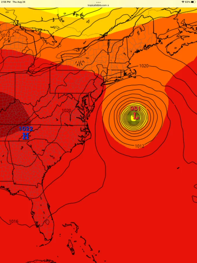
spot on call! Seems it is maybe our one system that could be a concern to the US, and its got some serious bathwater to work with, what is shear like between there and FL? If nothing to disrupt a monster could form, but as you said and rightfully so we have to not only wait for a system to actually develop, then we need a well defined COC and then we can have somewhat of an idea on track and still then only really 3 days out if that. One thing I know is TS/H can do crazy things in terms of tracks.sroc4 wrote:Here is that potential that I mentioned Monday and Tuesday. Lets see what evolves.
jmanley32- Senior Enthusiast
- Posts : 20516
Reputation : 108
Join date : 2013-12-12
Age : 42
Location : Yonkers, NY
Re: 2023 Atlantic Tropics season
![]() by jmanley32 Thu Aug 24, 2023 10:34 pm
by jmanley32 Thu Aug 24, 2023 10:34 pm
Yeah Franklin is not go be a threat to us except maybe large swells on LI and jersey shore. However the system coming out of the deep carrib is what the CMC showed doing a coastal at todays 12z too, still way way to far off. We don't even have a storm system yet.sroc4 wrote:weatherwatchermom wrote:amugs wrote:EURO says close shave peeps nad has trended west over the last few runs - lets see what its seeing in the next few days.
CMC showed a coastal raver yesterday at 12Z.
Some HUGE changes would have to take place at the 500mb level for that to be a concern. Not impossible, but not likely...for now
jmanley32- Senior Enthusiast
- Posts : 20516
Reputation : 108
Join date : 2013-12-12
Age : 42
Location : Yonkers, NY
Re: 2023 Atlantic Tropics season
![]() by sroc4 Fri Aug 25, 2023 2:59 pm
by sroc4 Fri Aug 25, 2023 2:59 pm

_________________
"In weather and in life, there's no winning and losing; there's only winning and learning."
WINTER 2012/2013 TOTALS 43.65"WINTER 2017/2018 TOTALS 62.85" WINTER 2022/2023 TOTALS 4.9"
WINTER 2013/2014 TOTALS 64.85"WINTER 2018/2019 TOTALS 14.25" WINTER 2023/2024 TOTALS 13.1"
WINTER 2014/2015 TOTALS 71.20"WINTER 2019/2020 TOTALS 6.35"
WINTER 2015/2016 TOTALS 35.00"WINTER 2020/2021 TOTALS 37.75"
WINTER 2016/2017 TOTALS 42.25"WINTER 2021/2022 TOTALS 31.65"
sroc4- Admin
- Posts : 8331
Reputation : 301
Join date : 2013-01-07
Location : Wading River, LI
Re: 2023 Atlantic Tropics season
![]() by weatherwatchermom Fri Aug 25, 2023 5:18 pm
by weatherwatchermom Fri Aug 25, 2023 5:18 pm
sroc4 wrote:NHC increasing odds of development for our Yucatan system. Worried for my buddy in Fort Meyers. Ive already bee in contact with him and he def has PTSD. Already making preparations to get the heck out of there. Rightfully so even if its a weak system. I dont blame him.
Oh boy .will keep your friend in my thoughts...let's hope that does not happen
weatherwatchermom- Senior Enthusiast
- Posts : 3738
Reputation : 77
Join date : 2014-11-25
Age : 60
Location : Hazlet Township, NJ
sroc4, docstox12 and dkodgis like this post
Re: 2023 Atlantic Tropics season
![]() by Dunnzoo Sat Aug 26, 2023 9:04 am
by Dunnzoo Sat Aug 26, 2023 9:04 am
sroc4 wrote:NHC increasing odds of development for our Yucatan system. Worried for my buddy in Fort Meyers. Ive already bee in contact with him and he def has PTSD. Already making preparations to get the heck out of there. Rightfully so even if its a weak system. I dont blame him.
My brother is in Cape Coral and still has a few repairs to make from the last time around. This looks to be a tad north of them, hoping it's just a rainstorm by then!
_________________
Janet
Snowfall winter of 2023-2024 17.5"
Snowfall winter of 2022-2023 6.0"
Snowfall winter of 2021-2022 17.6" 1" sleet 2/25/22
Snowfall winter of 2020-2021 51.1"
Snowfall winter of 2019-2020 8.5"
Snowfall winter of 2018-2019 25.1"
Snowfall winter of 2017-2018 51.9"
Snowfall winter of 2016-2017 45.6"
Snowfall winter of 2015-2016 29.5"
Snowfall winter of 2014-2015 50.55"
Snowfall winter of 2013-2014 66.5"

Dunnzoo- Senior Enthusiast - Mod
- Posts : 4891
Reputation : 68
Join date : 2013-01-11
Age : 62
Location : Westwood, NJ
docstox12, dkodgis and weatherwatchermom like this post
Page 2 of 20 • 1, 2, 3 ... 11 ... 20 ![]()
|
|
|