JAN 6th-7th Storm Thread I
+22
Coachgriff
CPcantmeasuresnow
phil155
docstox12
Artechmetals
Dunnzoo
DAYBLAZER
sroc4
frank 638
billg315
Irish
tomsriversnowstorm
dsix85
aiannone
amugs
SENJsnowman
rb924119
heehaw453
nutleyblizzard
jmanley32
dkodgis
Frank_Wx
26 posters
Page 8 of 16
Page 8 of 16 •  1 ... 5 ... 7, 8, 9 ... 12 ... 16
aiannone- Senior Enthusiast - Mod

- Posts : 4814
Join date : 2013-01-07
jmanley32 likes this post
 Re: JAN 6th-7th Storm Thread I
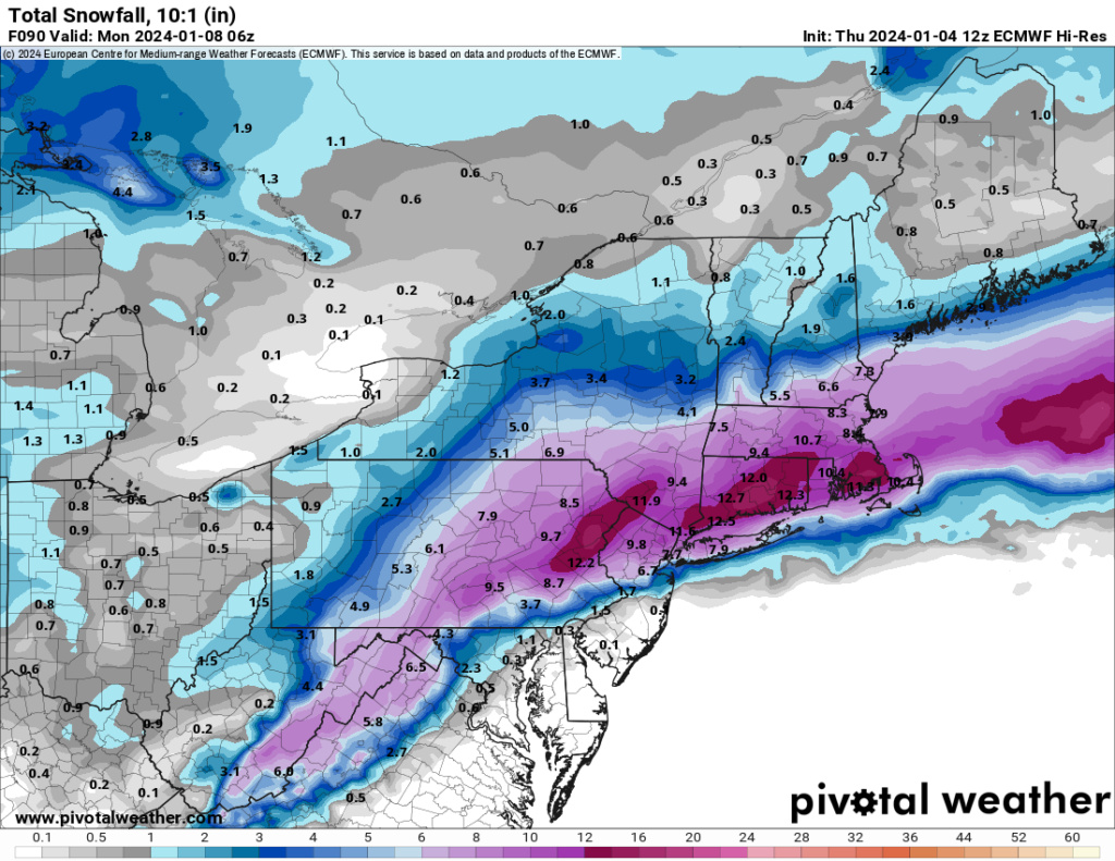
heehaw453 wrote:The thermal profile on 12Z Euro definitely better. The mid-level energy for the most part stayed just off shore. It's possible this thing could vertically stack and then that's when the Godzilla possibilities are possible IMO. I would say keep expectations in check with this for now...
To an extent, this is true. But the second part to this is by consolidating/tilting more negative sooner, you enhance your moisture fetch off the Atlantic, thus increasing your QPF while still maintaining your high-ratio airmass. We are slowly but steadily coming back toward the solutions we were seeing earlier this week. Do we get all the way there? I’m not sure, as H5 would need to significantly improve right quick. But we can get partially there, and that’s what you’re seeing now.
rb924119- Meteorologist

- Posts : 6890
Join date : 2013-02-06
CPcantmeasuresnow likes this post
 Re: JAN 6th-7th Storm Thread I
Wow. Positive trends! Is it simply possible that now our system is on land we’ve had better sampling with the latest runs and not the massive windshield wiper effect we often see when these systems start off in the Pacific before they enter land?
dsix85- Pro Enthusiast

- Posts : 349
Reputation : 8
Join date : 2014-01-01
Location : New York
amugs likes this post
 Re: JAN 6th-7th Storm Thread I
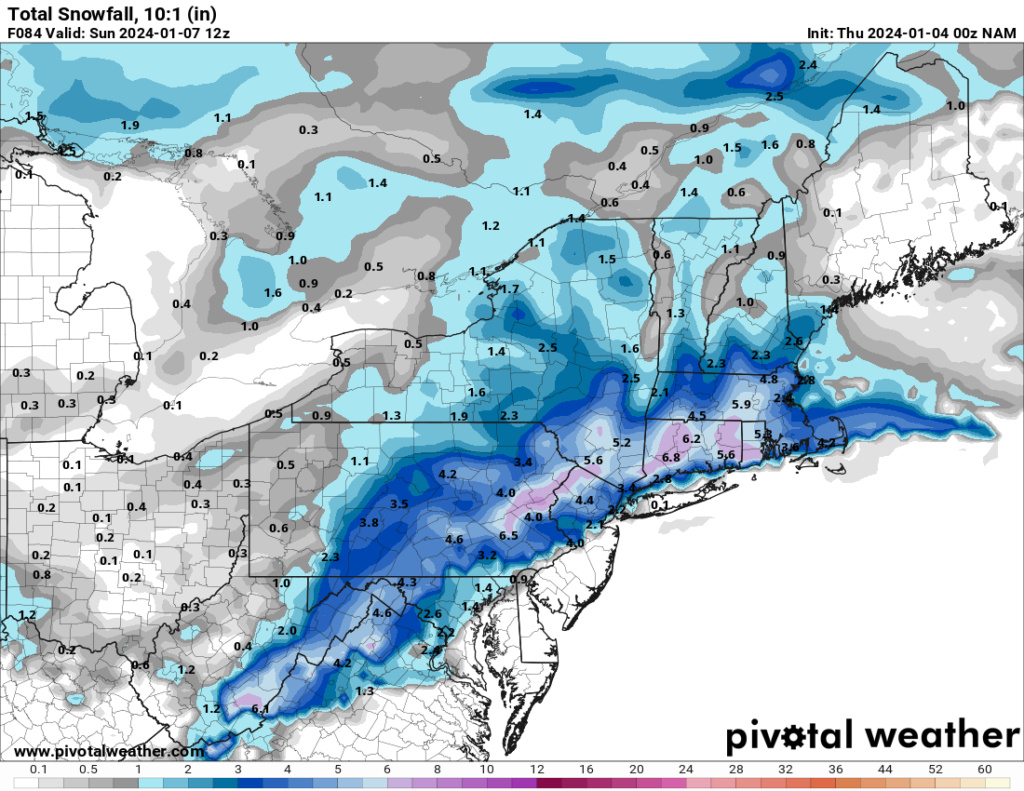
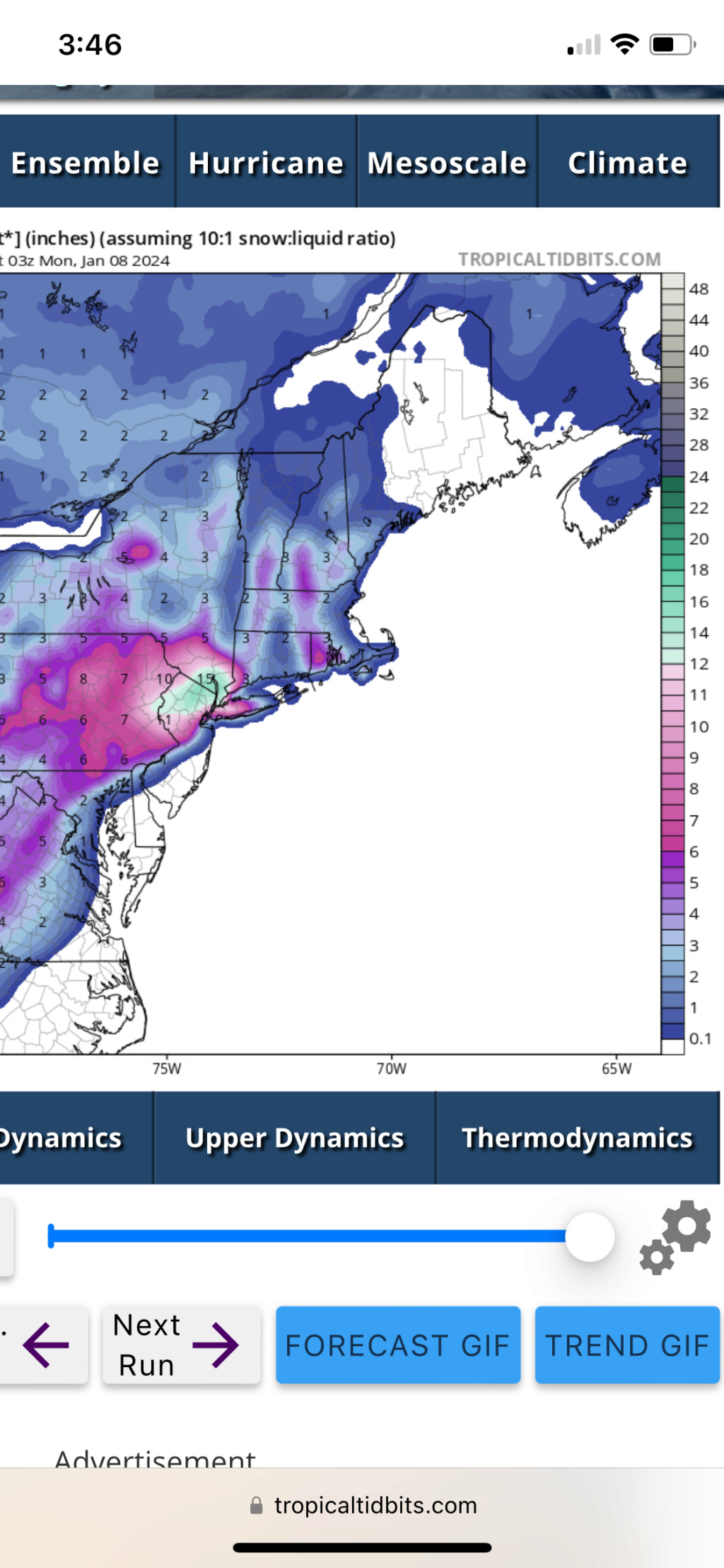
Euro where do I sign? Wish I could put stock in these snow maps but I know better now. Can't wait to see what the 3km NAM spits out lol 48 inches?

jmanley32- Senior Enthusiast

- Posts : 20517
Reputation : 108
Join date : 2013-12-12
Age : 42
Location : Yonkers, NY

jmanley32- Senior Enthusiast

- Posts : 20517
Reputation : 108
Join date : 2013-12-12
Age : 42
Location : Yonkers, NY
 Re: JAN 6th-7th Storm Thread I
_________________
Mugs
AKA:King: Snow Weenie
Self Proclaimed
WINTER 2014-15 : 55.12" +.02 for 6 coatings (avg. 35")
WINTER 2015-16 Total - 29.8" (Avg 35")
WINTER 2016-17 : 39.5" so far

amugs- Advanced Forecaster - Mod

- Posts : 15093
Reputation : 213
Join date : 2013-01-07
Age : 54
Location : Hillsdale,NJ
rb924119 likes this post
 Re: JAN 6th-7th Storm Thread I
Surface temps are > 32 for many on the coast (NYC/LI), but if this system becomes dynamic in nature the snow piles up regardless. Sure it'd be better to have mid 20's but it can still accumulate at 34.
heehaw453- Advanced Forecaster

- Posts : 3906
Reputation : 86
Join date : 2014-01-20
Location : Bedminster Township, PA Elevation 600' ASL
rb924119 likes this post
 Re: JAN 6th-7th Storm Thread I
heehaw453 wrote:Surface temps are > 32 for many on the coast (NYC/LI), but if this system becomes dynamic in nature the snow piles up regardless. Sure it'd be better to have mid 20's but it can still accumulate at 34.
and a decent chunk at night
_________________
-Alex Iannone-

aiannone- Senior Enthusiast - Mod

- Posts : 4814
Reputation : 92
Join date : 2013-01-07
Location : Saint James, LI (Northwest Suffolk Co.)
 Re: JAN 6th-7th Storm Thread I
Great take overall
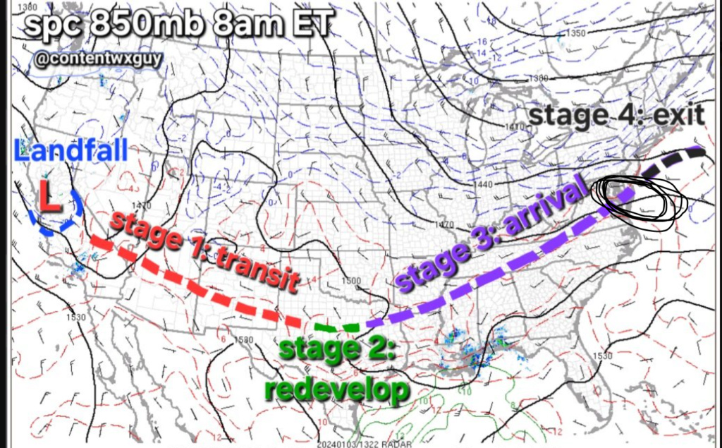
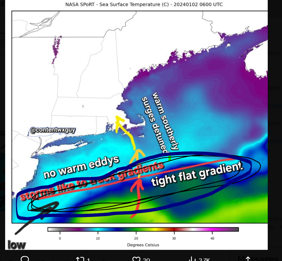
Cold air in place looking to linger & aided by reinforcement. The low, once it takes that right hitch eastward to exit along its own axis, will draw a lot of cold in.
— ContentWeatherGuy (@ContentWxGuy) January 4, 2024
Immediate coastal towns notwithstanding attm this is a southern new england, sny/nnj/ Midatl I-95 & NW snowstorm. pic.twitter.com/JTzH0LZQwR
_________________
Mugs
AKA:King: Snow Weenie
Self Proclaimed
WINTER 2014-15 : 55.12" +.02 for 6 coatings (avg. 35")
WINTER 2015-16 Total - 29.8" (Avg 35")
WINTER 2016-17 : 39.5" so far

amugs- Advanced Forecaster - Mod

- Posts : 15093
Reputation : 213
Join date : 2013-01-07
Age : 54
Location : Hillsdale,NJ
rb924119 and essexcountypete like this post
 Re: JAN 6th-7th Storm Thread I
Latest SREFS look better still from early peeks. Waiting on more maps to come out, but the trend of earlier organization/more negative tilt at the low levels appears to be gaining traction. Even they have cooked some and now also close off the 850 hPa circulation over coastal NJ as opposed to southern New England before. Very interested to see the other maps once they’re out. Bet they trend wetter too….
rb924119- Meteorologist

- Posts : 6890
Reputation : 194
Join date : 2013-02-06
Age : 32
Location : Greentown, Pa
 Re: JAN 6th-7th Storm Thread I
Slightly wetter.
rb924119- Meteorologist

- Posts : 6890
Reputation : 194
Join date : 2013-02-06
Age : 32
Location : Greentown, Pa
 Re: JAN 6th-7th Storm Thread I
I disagree that it’s a Godzilla for most. I think it’s fairly concentrated over N&W / elevated areas. It’s important to take other factors into consideration such as wind direction, mid level vorticity, surface temps, etc. I can see this start at 8:1 ratio then gradually turn into 10:1 and maybe even 12:1 for the coast, but the initial precip that falls won’t stick right away. It does help that it’s primarily coming at night.
_________________
_______________________________________________________________________________________________________
CLICK HERE to view NJ Strong Snowstorm Classifications
 Re: JAN 6th-7th Storm Thread I
rb924119 wrote:Latest SREFS look better still from early peeks. Waiting on more maps to come out, but the trend of earlier organization/more negative tilt at the low levels appears to be gaining traction. Even they have cooked some and now also close off the 850 hPa circulation over coastal NJ as opposed to southern New England before. Very interested to see the other maps once they’re out. Bet they trend wetter too….
Definitely better. There is definitely a hint of more interaction into the backside of the lead energy at H5 too, but I don’t think we will get all the way there. New England has a legitimate chance, though. 18z NAM could be interesting haha
rb924119- Meteorologist

- Posts : 6890
Reputation : 194
Join date : 2013-02-06
Age : 32
Location : Greentown, Pa
 Re: JAN 6th-7th Storm Thread I
Frank_Wx wrote:
I disagree that it’s a Godzilla for most. I think it’s fairly concentrated over N&W / elevated areas. It’s important to take other factors into consideration such as wind direction, mid level vorticity, surface temps, etc. I can see this start at 8:1 ratio then gradually turn into 10:1 and maybe even 12:1 for the coast, but the initial precip that falls won’t stick right away. It does help that it’s primarily coming at night.
Out of intellectual curiosity, why are you using those ratios?
rb924119- Meteorologist

- Posts : 6890
Reputation : 194
Join date : 2013-02-06
Age : 32
Location : Greentown, Pa
 Re: JAN 6th-7th Storm Thread I
very serious cutoff on the euro in middlesex county
phil155- Pro Enthusiast

- Posts : 475
Reputation : 4
Join date : 2019-12-16
 Re: JAN 6th-7th Storm Thread I
rb924119 wrote:Frank_Wx wrote:jmanley32 wrote:If CP comes back on here with his doom and gloom with this look for the storm I will lose my you know what lol. What does it need to do to shift the cold enough to the coast to see more than 2 inches (I mean NYC and my area, not LI, sorry LIlooks like this may be a tough one.
Refer to my blog post. The true cold air is up in Canada. The current air mass is cold enough for snow, but it’s pretty marginal for the coast.
Welcome back, fearless leader!
I'm going to respectfully disagree that the airmass is marginal for the coast (aside from the lowest levels, i.e. sub-950 hPa). This actually gets back to a question that @Dunnzoo asked me earlier, about snow ratios, as well, in that the airmass that we will have in place is largely very conducive for snow, especially if we get the subtle southward shift that I am expecting. Here's a look at a sounding from the Euro for KNYC during the heart of the storm:
Note how I have the temperatures annotated on multiple levels in blue (in ºC). In order to assess the thermal profile, and get an accurate representation the atmosphere, you have to first figure out where your forcing mechanisms are located in the vertical. For example, there are some situations where you have strong mid-level forcing, but very little help from an upper-level jet or lower-level frontogenesis. In that case, you would want to weight your thermal profile calculations accordingly to account for that. In this, case, though, we have decent forcing for ascent throughout the atmospheric column. We have lower-level frontogenesis, mid-level vorticity advection, and upper-level jet support from AT LEAST one jet streak, arguably two, in my opinion. So, we can equally weight each temperature reading at each level, and we take a temperature reading through the atmospheric column until we run out of forcing (basically when we get to jet level). So, if you subtract all of those numbers (since they are negatives) you get the following:
9 total readings = -133
Divide the -133/9 to get the average temperature of the atmospheric column, through which you're getting ascent and snow development: -14.8ºC.
Ok, now this is where it gets interesting, because this value gives you information for two things: Snow ratios and crystal formation tendencies.
Let's look at snow ratios first:
Temperature runs along the bottom, ratio along the vertical axis. As you can see, based on the average temperature of our column, you exceed 20:1. Now, this is not stagnant - as the storm evolves, so does your average atmospheric temperature. But, I've already looked and this generally remains fairly steady-state. However, lets play it conservative and say you lose some snow to melting while cooling the lower column initially, and say your average snowfall ratio will be somewhere between 18-20:1.
Next, let's look at crystal formation tendency based on our average atomspheric temperature:
As you can see, we are right in the sweet spot for plates and dendrites - the most efficient snowfall accumulators.
If you apply this to the average output of liquid equivalency among the major models (~1"), you can see how I was estimating my upper bound as 18-20" with this event.
Dunnz, hopefully that clarifies a bit for ya
I think I get your logic here with the science a little bit, but it just seems like it's too close to freezing that it would be a dry snow here in NENJ and the NYC area.
_________________
Janet
Snowfall winter of 2023-2024 17.5"
Snowfall winter of 2022-2023 6.0"
Snowfall winter of 2021-2022 17.6" 1" sleet 2/25/22
Snowfall winter of 2020-2021 51.1"
Snowfall winter of 2019-2020 8.5"
Snowfall winter of 2018-2019 25.1"
Snowfall winter of 2017-2018 51.9"
Snowfall winter of 2016-2017 45.6"
Snowfall winter of 2015-2016 29.5"
Snowfall winter of 2014-2015 50.55"
Snowfall winter of 2013-2014 66.5"
Dunnzoo- Senior Enthusiast - Mod

- Posts : 4892
Reputation : 68
Join date : 2013-01-11
Age : 62
Location : Westwood, NJ
rb924119 likes this post
 Re: JAN 6th-7th Storm Thread I
It’ll be close in the lowest levels of the atmosphere, but not aloft where the precipitation process will actually be occurring.
rb924119- Meteorologist

- Posts : 6890
Reputation : 194
Join date : 2013-02-06
Age : 32
Location : Greentown, Pa
 Re: JAN 6th-7th Storm Thread I
18z NAM colder.
rb924119- Meteorologist

- Posts : 6890
Reputation : 194
Join date : 2013-02-06
Age : 32
Location : Greentown, Pa
 Re: JAN 6th-7th Storm Thread I
Lower level circulations exit the Delmarva 
rb924119- Meteorologist

- Posts : 6890
Reputation : 194
Join date : 2013-02-06
Age : 32
Location : Greentown, Pa
 Re: JAN 6th-7th Storm Thread I
Nam Precip chasing convection
_________________
"In weather and in life, there's no winning and losing; there's only winning and learning."
WINTER 2012/2013 TOTALS 43.65"WINTER 2017/2018 TOTALS 62.85" WINTER 2022/2023 TOTALS 4.9"
WINTER 2013/2014 TOTALS 64.85"WINTER 2018/2019 TOTALS 14.25" WINTER 2023/2024 TOTALS 13.1"
WINTER 2014/2015 TOTALS 71.20"WINTER 2019/2020 TOTALS 6.35"
WINTER 2015/2016 TOTALS 35.00"WINTER 2020/2021 TOTALS 37.75"
WINTER 2016/2017 TOTALS 42.25"WINTER 2021/2022 TOTALS 31.65"

sroc4- Admin

- Posts : 8331
Reputation : 301
Join date : 2013-01-07
Location : Wading River, LI
heehaw453 likes this post
 Re: JAN 6th-7th Storm Thread I
rb924119 wrote:Lower level circulations exit the Delmarva
Be getting nam'd a bit it seems.
heehaw453- Advanced Forecaster

- Posts : 3906
Reputation : 86
Join date : 2014-01-20
Location : Bedminster Township, PA Elevation 600' ASL
 Re: JAN 6th-7th Storm Thread I
Here comes the wrap-around thanks to the incoming H5 energy plus leftover FGEN from better lower-level circulations.
rb924119- Meteorologist

- Posts : 6890
Reputation : 194
Join date : 2013-02-06
Age : 32
Location : Greentown, Pa
 Re: JAN 6th-7th Storm Thread I
heehaw453 wrote:rb924119 wrote:Lower level circulations exit the Delmarva
Be getting nam'd a bit it seems.
You can say that again lol
rb924119- Meteorologist

- Posts : 6890
Reputation : 194
Join date : 2013-02-06
Age : 32
Location : Greentown, Pa
 Re: JAN 6th-7th Storm Thread I
Yeah but from there just when it was getting down to business, the CCB band disappears and the precip shield fizzles on the western flank. Didn’t make much sense with all the parameters seemingly in place.rb924119 wrote:Lower level circulations exit the Delmarva

nutleyblizzard- Senior Enthusiast

- Posts : 1952
Reputation : 41
Join date : 2014-01-30
Age : 58
Location : Nutley, new jersey
rb924119- Meteorologist

- Posts : 6890
Reputation : 194
Join date : 2013-02-06
Age : 32
Location : Greentown, Pa
 Re: JAN 6th-7th Storm Thread I
In short, that’s what I meant to say.sroc4 wrote:Nam Precip chasing convection

nutleyblizzard- Senior Enthusiast

- Posts : 1952
Reputation : 41
Join date : 2014-01-30
Age : 58
Location : Nutley, new jersey
sroc4 likes this post
 Re: JAN 6th-7th Storm Thread I
The wrap around snows from the GFS is absolutely insane now! As long as the ground isn’t too wet most of New Jersey could close this storm out with some snow pack!
Coachgriff- Posts : 57
Reputation : 0
Join date : 2022-01-29
Page 8 of 16 •  1 ... 5 ... 7, 8, 9 ... 12 ... 16
Page 8 of 16
Permissions in this forum:
You cannot reply to topics in this forum|
|
|

 Home
Home