JAN 6th-7th Storm Thread I
+22
Coachgriff
CPcantmeasuresnow
phil155
docstox12
Artechmetals
Dunnzoo
DAYBLAZER
sroc4
frank 638
billg315
Irish
tomsriversnowstorm
dsix85
aiannone
amugs
SENJsnowman
rb924119
heehaw453
nutleyblizzard
jmanley32
dkodgis
Frank_Wx
26 posters
Page 2 of 16
Page 2 of 16 •  1, 2, 3 ... 9 ... 16
 Re: JAN 6th-7th Storm Thread I
Yea I am hoping the pattern shifts and we can get some snow chances later in the month and February. Just too warm right now. I will say this has been fun to watch and learn.
billg315 wrote:How the world turns. Yesterday the Euro was our best bet and we were hoping the GFS was out to lunch. Now the GFS is more encouraging than the Euro. lol.
My initial thought, with the caveat that we won't really zero-in on this until late tomorrow or Friday, is that the dividing line here ends up being roughly along the fall line or the I-95. I think north and west of that line is a 6-10" type snow. Along or just either side of that line is about 3-5" with rain mixing in the middle before ending as snow. And South and east mostly rain with maybe some snow at the outset Saturday evening and lighter back-end snows Sunday AM.
This is a very rough estimate -- which is about all I think anyone can give at this stage with the models still waffling.
tomsriversnowstorm- Posts : 90
Join date : 2021-02-06
 Re: JAN 6th-7th Storm Thread I
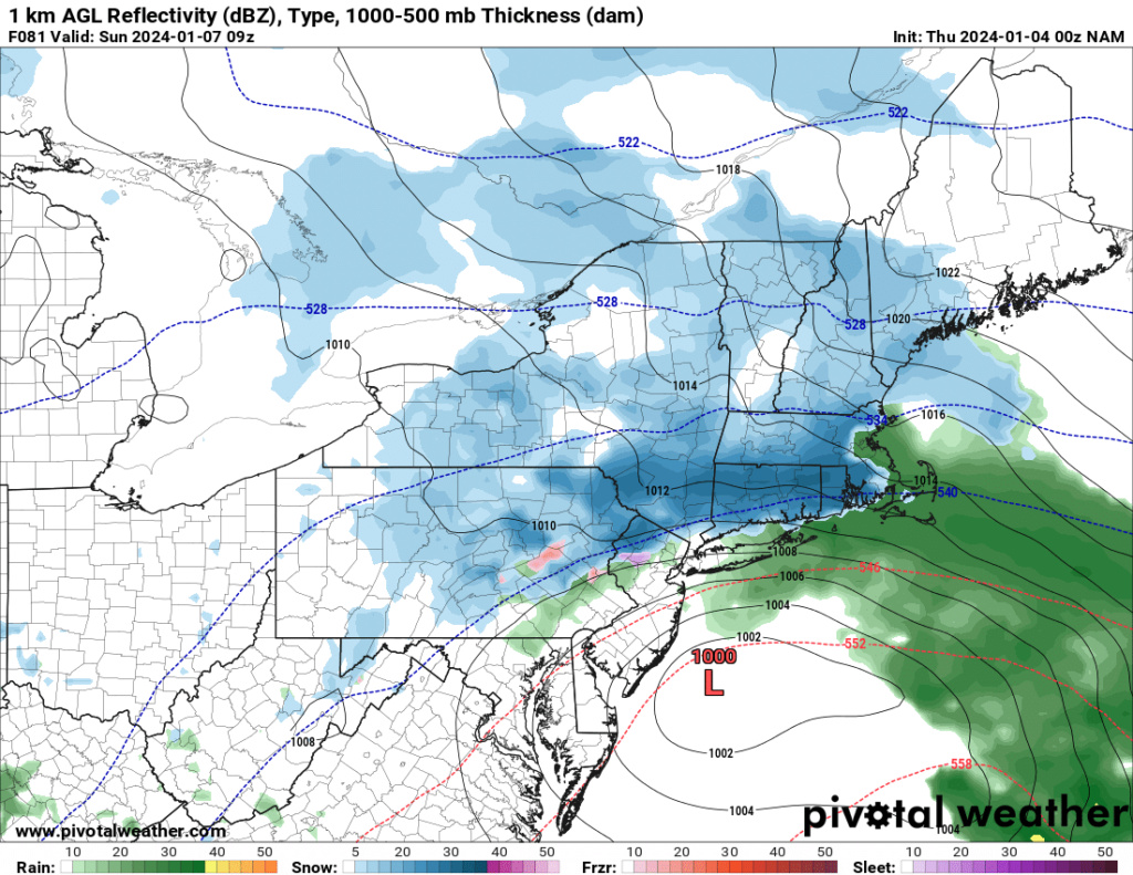
NAM woke up. Looks a lot better than it did today lol
rb924119- Meteorologist

- Posts : 6890
Join date : 2013-02-06
 Re: JAN 6th-7th Storm Thread I
_________________
-Alex Iannone-

aiannone- Senior Enthusiast - Mod

- Posts : 4813
Reputation : 92
Join date : 2013-01-07
Location : Saint James, LI (Northwest Suffolk Co.)
 Re: JAN 6th-7th Storm Thread I
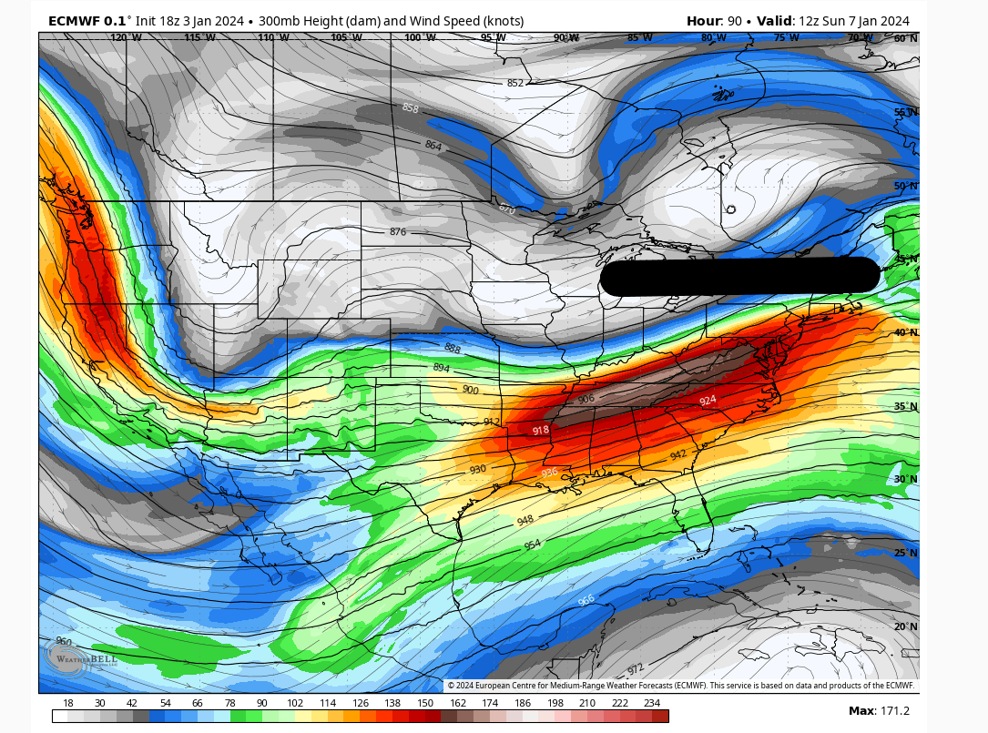
heehaw453 wrote:One thing is becoming is becoming clear there is a lot of mid-level energy that is being pushed up by the s/s jet.
I want to see this n/s jet compress the flow a bit more to 1/keep the storm more easterly, 2/force earlier consolidation. If those two things can occur then I think this turns into something we only are getting glimpses of from time to time.
18Z Euro
Check H5 on 00z NAM lol it’s CLOSE. As it is, it creates enough forcing to extend the entire shield of precip all the way back to Pittsburg haha one more step like that aloft, and Mr. Man, we’ve got a whole other ballgame to play.
Last edited by rb924119 on Wed Jan 03, 2024 9:48 pm; edited 1 time in total
rb924119- Meteorologist

- Posts : 6890
Reputation : 194
Join date : 2013-02-06
Age : 32
Location : Greentown, Pa
1190ftalt likes this post

aiannone- Senior Enthusiast - Mod

- Posts : 4813
Reputation : 92
Join date : 2013-01-07
Location : Saint James, LI (Northwest Suffolk Co.)
 Re: JAN 6th-7th Storm Thread I
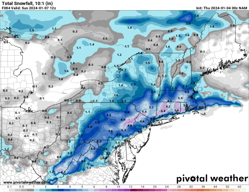
If CP comes back on here with his doom and gloom with this look for the storm I will lose my you know what lol. What does it need to do to shift the cold enough to the coast to see more than 2 inches (I mean NYC and my area, not LI, sorry LIlooks like this may be a tough one.

jmanley32- Senior Enthusiast

- Posts : 20516
Reputation : 108
Join date : 2013-12-12
Age : 42
Location : Yonkers, NY
 Re: JAN 6th-7th Storm Thread I
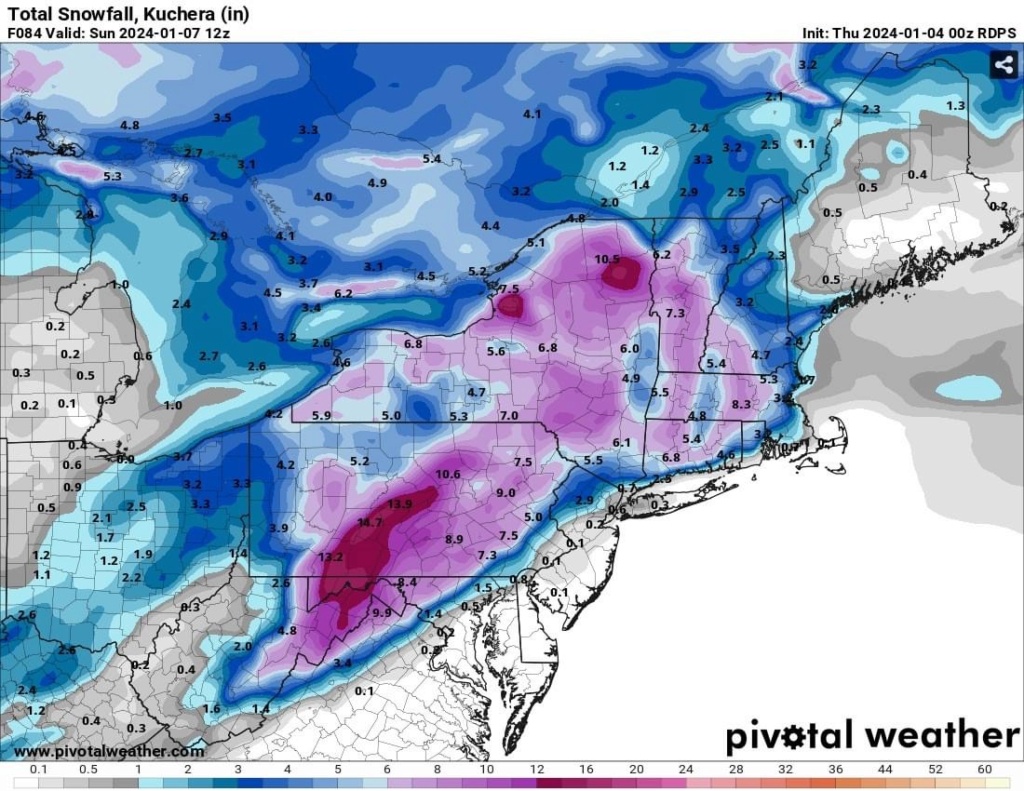
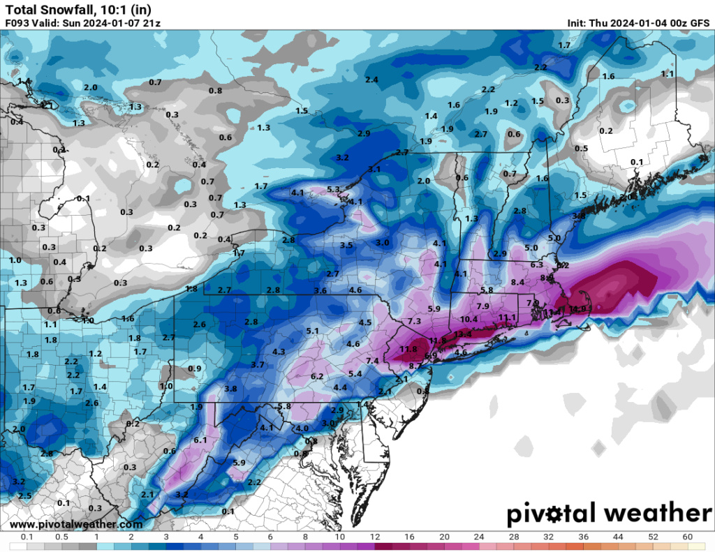
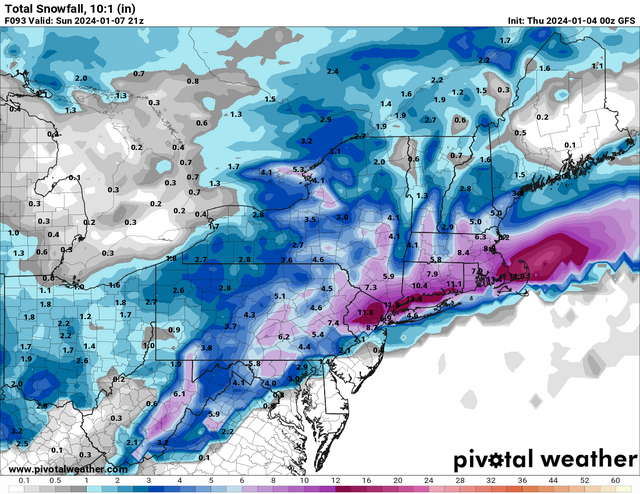
This map outlines my probabilistic map pretty well. I agree that the highest accumulations will fall N&W of I-95 for this one. To be honest, even if the low takes a more southerly track, I still think NYC S&E struggles to see anything more than 3”. Not a great setup for us coasties.
_________________
_______________________________________________________________________________________________________
CLICK HERE to view NJ Strong Snowstorm Classifications
 Re: JAN 6th-7th Storm Thread I
jmanley32 wrote:If CP comes back on here with his doom and gloom with this look for the storm I will lose my you know what lol. What does it need to do to shift the cold enough to the coast to see more than 2 inches (I mean NYC and my area, not LI, sorry LIlooks like this may be a tough one.
Refer to my blog post. The true cold air is up in Canada. The current air mass is cold enough for snow, but it’s pretty marginal for the coast.
_________________
_______________________________________________________________________________________________________
CLICK HERE to view NJ Strong Snowstorm Classifications
 Re: JAN 6th-7th Storm Thread I
Frank do we have a chance of that cold air getting here this winter or does it stay in Canada?
Found the answer. Sorry about that.
Found the answer. Sorry about that.
Frank_Wx wrote:jmanley32 wrote:If CP comes back on here with his doom and gloom with this look for the storm I will lose my you know what lol. What does it need to do to shift the cold enough to the coast to see more than 2 inches (I mean NYC and my area, not LI, sorry LIlooks like this may be a tough one.
Refer to my blog post. The true cold air is up in Canada. The current air mass is cold enough for snow, but it’s pretty marginal for the coast.
Last edited by tomsriversnowstorm on Wed Jan 03, 2024 10:08 pm; edited 1 time in total
tomsriversnowstorm- Posts : 90
Reputation : 0
Join date : 2021-02-06
 Re: JAN 6th-7th Storm Thread I
Welcome back Frank I hope you had a good time on your honeymoon.
Do u think nyc will see snow and sleet or a messy rain and snow
Do u think nyc will see snow and sleet or a messy rain and snow
frank 638- Senior Enthusiast

- Posts : 2824
Reputation : 37
Join date : 2016-01-01
Age : 40
Location : bronx ny
 Re: JAN 6th-7th Storm Thread I
Yeah I recall reading that, I think I am set with this one I think we know what the outcome will be fore the coast either rain maybe 3 inches tops. If theres a drastic change I will come back. Hopefully congrats to the N/W people, some of those who gave up completely on winter 7-8 days out from this storm....At least I am not too let down because as I said I was not expecting much, I guess ill enjoy my time in CT until Sat afternoon cuz ill be inland in eastern CT so they will probably see 3-6 looks like.Frank_Wx wrote:jmanley32 wrote:If CP comes back on here with his doom and gloom with this look for the storm I will lose my you know what lol. What does it need to do to shift the cold enough to the coast to see more than 2 inches (I mean NYC and my area, not LI, sorry LIlooks like this may be a tough one.
Refer to my blog post. The true cold air is up in Canada. The current air mass is cold enough for snow, but it’s pretty marginal for the coast.

jmanley32- Senior Enthusiast

- Posts : 20516
Reputation : 108
Join date : 2013-12-12
Age : 42
Location : Yonkers, NY
 Re: JAN 6th-7th Storm Thread I
frank 638 wrote:Welcome back Frank I hope you had a good time on your honeymoon.
Do u think nyc will see snow and sleet or a messy rain and snow
I still think accumulation is on the table. Hard to say if there will be a changeover or not. I would put it at 50-50 right now.
_________________
_______________________________________________________________________________________________________
CLICK HERE to view NJ Strong Snowstorm Classifications
frank 638 likes this post

aiannone- Senior Enthusiast - Mod

- Posts : 4813
Reputation : 92
Join date : 2013-01-07
Location : Saint James, LI (Northwest Suffolk Co.)

aiannone- Senior Enthusiast - Mod

- Posts : 4813
Reputation : 92
Join date : 2013-01-07
Location : Saint James, LI (Northwest Suffolk Co.)
 Re: JAN 6th-7th Storm Thread I
_________________
_______________________________________________________________________________________________________
CLICK HERE to view NJ Strong Snowstorm Classifications
 Re: JAN 6th-7th Storm Thread I
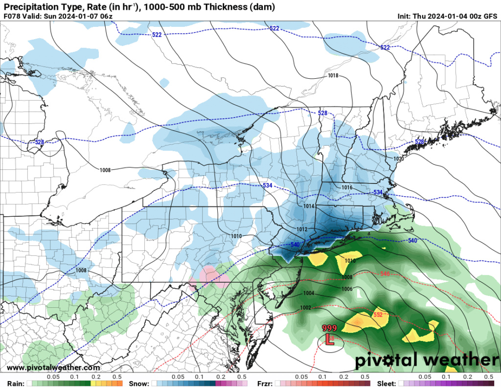
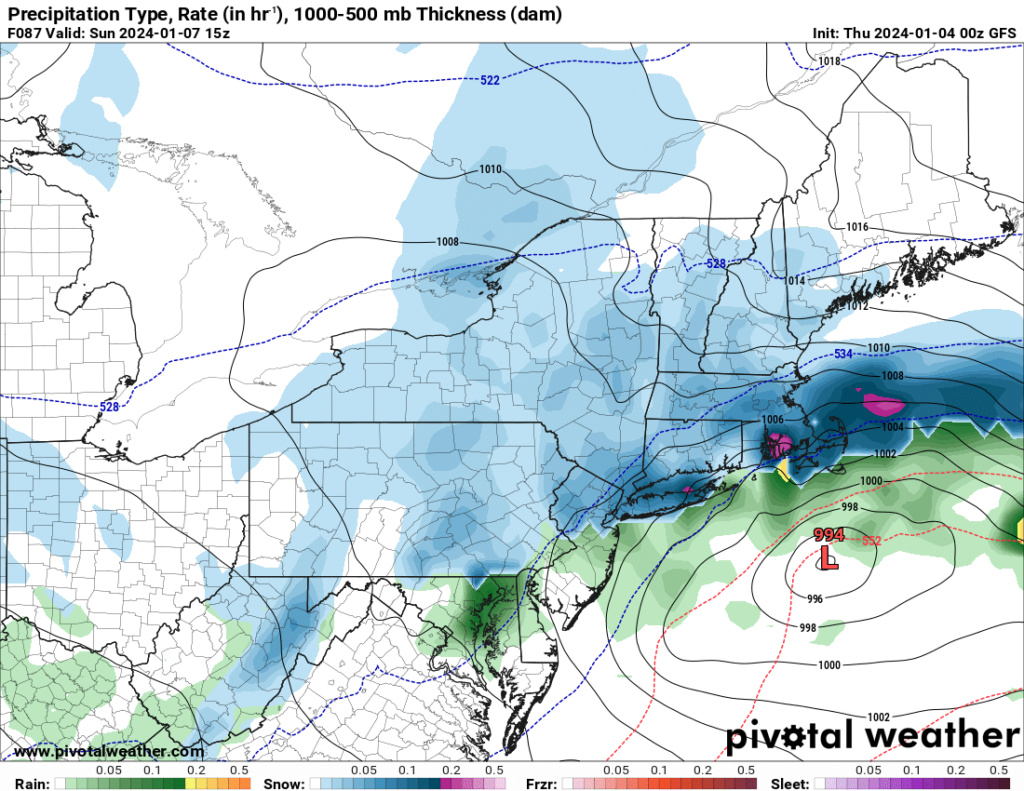
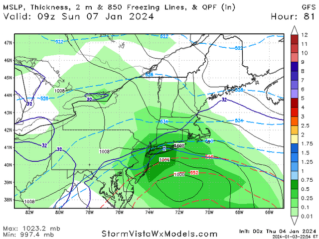
Haha Frank. We will indeed see tomorrow if models correct back but this looks to be quickly becoming an eastern New England storm. In fact our area is dryslotted. It is only Wednesday so still room….
_________________
-Alex Iannone-

aiannone- Senior Enthusiast - Mod

- Posts : 4813
Reputation : 92
Join date : 2013-01-07
Location : Saint James, LI (Northwest Suffolk Co.)
 Re: JAN 6th-7th Storm Thread I
billg315 wrote:How the world turns. Yesterday the Euro was our best bet and we were hoping the GFS was out to lunch. Now the GFS is more encouraging than the Euro. lol.
My initial thought, with the caveat that we won't really zero-in on this until late tomorrow or Friday, is that the dividing line here ends up being roughly along the fall line or the I-95. I think north and west of that line is a 6-10" type snow. Along or just either side of that line is about 3-5" with rain mixing in the middle before ending as snow. And South and east mostly rain with maybe some snow at the outset Saturday evening and lighter back-end snows Sunday AM.
This is a very rough estimate -- which is about all I think anyone can give at this stage with the models still waffling.
Yes. The meso's are now confirming a lot of energy being transported by a strong s/s jet. My guess is this waffling goes on until Friday 12Z runs. So tomorrow (Thursday) we will see the snow lines push a touch S/E of I95 and the final push will be back north on I95 pretty much like you're saying. Caveats stalling energy or faster consolidation then not sure do places like LI get slammed? Maybe. Truth be told I'm a bit unsure about NYC/LI as the setup does lend itself to several inches IMO and I just don't buy LI rains this entire time especially on the north shore.
heehaw453- Advanced Forecaster

- Posts : 3906
Reputation : 86
Join date : 2014-01-20
Location : Bedminster Township, PA Elevation 600' ASL
 Re: JAN 6th-7th Storm Thread I
Frank jinxed it by starting this thread. Sorry Frank but it’s true.
_________________
"In weather and in life, there's no winning and losing; there's only winning and learning."
WINTER 2012/2013 TOTALS 43.65"WINTER 2017/2018 TOTALS 62.85" WINTER 2022/2023 TOTALS 4.9"
WINTER 2013/2014 TOTALS 64.85"WINTER 2018/2019 TOTALS 14.25" WINTER 2023/2024 TOTALS 13.1"
WINTER 2014/2015 TOTALS 71.20"WINTER 2019/2020 TOTALS 6.35"
WINTER 2015/2016 TOTALS 35.00"WINTER 2020/2021 TOTALS 37.75"
WINTER 2016/2017 TOTALS 42.25"WINTER 2021/2022 TOTALS 31.65"

sroc4- Admin

- Posts : 8331
Reputation : 301
Join date : 2013-01-07
Location : Wading River, LI
Frank_Wx likes this post
 Re: JAN 6th-7th Storm Thread I
Frank_Wx wrote:jmanley32 wrote:If CP comes back on here with his doom and gloom with this look for the storm I will lose my you know what lol. What does it need to do to shift the cold enough to the coast to see more than 2 inches (I mean NYC and my area, not LI, sorry LIlooks like this may be a tough one.
Refer to my blog post. The true cold air is up in Canada. The current air mass is cold enough for snow, but it’s pretty marginal for the coast.
Welcome back, fearless leader!
I'm going to respectfully disagree that the airmass is marginal for the coast (aside from the lowest levels, i.e. sub-950 hPa). This actually gets back to a question that @Dunnzoo asked me earlier, about snow ratios, as well, in that the airmass that we will have in place is largely very conducive for snow, especially if we get the subtle southward shift that I am expecting. Here's a look at a sounding from the Euro for KNYC during the heart of the storm:

Note how I have the temperatures annotated on multiple levels in blue (in ºC). In order to assess the thermal profile, and get an accurate representation the atmosphere, you have to first figure out where your forcing mechanisms are located in the vertical. For example, there are some situations where you have strong mid-level forcing, but very little help from an upper-level jet or lower-level frontogenesis. In that case, you would want to weight your thermal profile calculations accordingly to account for that. In this, case, though, we have decent forcing for ascent throughout the atmospheric column. We have lower-level frontogenesis, mid-level vorticity advection, and upper-level jet support from AT LEAST one jet streak, arguably two, in my opinion. So, we can equally weight each temperature reading at each level, and we take a temperature reading through the atmospheric column until we run out of forcing (basically when we get to jet level). So, if you subtract all of those numbers (since they are negatives) you get the following:
9 total readings = -133
Divide the -133/9 to get the average temperature of the atmospheric column, through which you're getting ascent and snow development: -14.8ºC.
Ok, now this is where it gets interesting, because this value gives you information for two things: Snow ratios and crystal formation tendencies.
Let's look at snow ratios first:

Temperature runs along the bottom, ratio along the vertical axis. As you can see, based on the average temperature of our column, you exceed 20:1. Now, this is not stagnant - as the storm evolves, so does your average atmospheric temperature. But, I've already looked and this generally remains fairly steady-state. However, lets play it conservative and say you lose some snow to melting while cooling the lower column initially, and say your average snowfall ratio will be somewhere between 18-20:1.
Next, let's look at crystal formation tendency based on our average atomspheric temperature:

As you can see, we are right in the sweet spot for plates and dendrites - the most efficient snowfall accumulators.
If you apply this to the average output of liquid equivalency among the major models (~1"), you can see how I was estimating my upper bound as 18-20" with this event.
Dunnz, hopefully that clarifies a bit for ya
rb924119- Meteorologist

- Posts : 6890
Reputation : 194
Join date : 2013-02-06
Age : 32
Location : Greentown, Pa
sroc4 and heehaw453 like this post
 Re: JAN 6th-7th Storm Thread I
There were several GFS runs with 0” of snow before this thread was created! The snow drought is causing desperation to settle in. We have to stay strong!
_________________
_______________________________________________________________________________________________________
CLICK HERE to view NJ Strong Snowstorm Classifications
sroc4, kalleg, heehaw453, weatherwatchermom and Norge55 like this post
 Re: JAN 6th-7th Storm Thread I
I believe some of you are on Steps 8, 9, and 10 now lol
rb924119- Meteorologist

- Posts : 6890
Reputation : 194
Join date : 2013-02-06
Age : 32
Location : Greentown, Pa
Frank_Wx and sroc4 like this post
 Re: JAN 6th-7th Storm Thread I
rb924119 wrote:Frank_Wx wrote:jmanley32 wrote:If CP comes back on here with his doom and gloom with this look for the storm I will lose my you know what lol. What does it need to do to shift the cold enough to the coast to see more than 2 inches (I mean NYC and my area, not LI, sorry LIlooks like this may be a tough one.
Refer to my blog post. The true cold air is up in Canada. The current air mass is cold enough for snow, but it’s pretty marginal for the coast.
Welcome back, fearless leader!
I'm going to respectfully disagree that the airmass is marginal for the coast (aside from the lowest levels, i.e. sub-950 hPa). This actually gets back to a question that @Dunnzoo asked me earlier, about snow ratios, as well, in that the airmass that we will have in place is largely very conducive for snow, especially if we get the subtle southward shift that I am expecting. Here's a look at a sounding from the Euro for KNYC during the heart of the storm:
Note how I have the temperatures annotated on multiple levels in blue (in ºC). In order to assess the thermal profile, and get an accurate representation the atmosphere, you have to first figure out where your forcing mechanisms are located in the vertical. For example, there are some situations where you have strong mid-level forcing, but very little help from an upper-level jet or lower-level frontogenesis. In that case, you would want to weight your thermal profile calculations accordingly to account for that. In this, case, though, we have decent forcing for ascent throughout the atmospheric column. We have lower-level frontogenesis, mid-level vorticity advection, and upper-level jet support from AT LEAST one jet streak, arguably two, in my opinion. So, we can equally weight each temperature reading at each level, and we take a temperature reading through the atmospheric column until we run out of forcing (basically when we get to jet level). So, if you subtract all of those numbers (since they are negatives) you get the following:
9 total readings = -133
Divide the -133/9 to get the average temperature of the atmospheric column, through which you're getting ascent and snow development: -14.8ºC.
Ok, now this is where it gets interesting, because this value gives you information for two things: Snow ratios and crystal formation tendencies.
Let's look at snow ratios first:
Temperature runs along the bottom, ratio along the vertical axis. As you can see, based on the average temperature of our column, you exceed 20:1. Now, this is not stagnant - as the storm evolves, so does your average atmospheric temperature. But, I've already looked and this generally remains fairly steady-state. However, lets play it conservative and say you lose some snow to melting while cooling the lower column initially, and say your average snowfall ratio will be somewhere between 18-20:1.
Next, let's look at crystal formation tendency based on our average atomspheric temperature:
As you can see, we are right in the sweet spot for plates and dendrites - the most efficient snowfall accumulators.
If you apply this to the average output of liquid equivalency among the major models (~1"), you can see how I was estimating my upper bound as 18-20" with this event.
Dunnz, hopefully that clarifies a bit for ya
This is fantastic! The science makes perfect sense. Where I’ll disagree, and try to provide more data tomorrow, is with this part:
In this, case, though, we have decent forcing for ascent throughout the atmospheric column. We have lower-level frontogenesis, mid-level vorticity advection, and upper-level jet support from AT LEAST one jet streak, arguably two, in my opinion. So, we can equally weight each temperature reading at each level
Specifically upper level jet support and mid level vorticity is questionable to me. At least at this time. No doubt we have the southern jet helping to usher mid level vorticity into the main system, but the timing at which this all comes together concerns me. I think if you were to take this temperature reading for Boston, then you can apply this logic and get an accurate number. But I think there’s some pieces missing right now for NYC. Basically you’re saying if NYC sees 1” of qpf, they will get 18” of snow? I’m having a hard time even believing 30% of that number right now haha.
_________________
_______________________________________________________________________________________________________
CLICK HERE to view NJ Strong Snowstorm Classifications
rb924119 likes this post

aiannone- Senior Enthusiast - Mod

- Posts : 4813
Reputation : 92
Join date : 2013-01-07
Location : Saint James, LI (Northwest Suffolk Co.)

aiannone- Senior Enthusiast - Mod

- Posts : 4813
Reputation : 92
Join date : 2013-01-07
Location : Saint James, LI (Northwest Suffolk Co.)
 Re: JAN 6th-7th Storm Thread I
_________________
_______________________________________________________________________________________________________
CLICK HERE to view NJ Strong Snowstorm Classifications

aiannone- Senior Enthusiast - Mod

- Posts : 4813
Reputation : 92
Join date : 2013-01-07
Location : Saint James, LI (Northwest Suffolk Co.)
 Re: JAN 6th-7th Storm Thread I
_________________
_______________________________________________________________________________________________________
CLICK HERE to view NJ Strong Snowstorm Classifications
Page 2 of 16 •  1, 2, 3 ... 9 ... 16
Page 2 of 16
Permissions in this forum:
You cannot reply to topics in this forum|
|
|

 Home
Home