JAN 28th-30th 2024 Potential system compliments of a +PNA
Page 1 of 5 • 1, 2, 3, 4, 5 
 JAN 28th-30th 2024 Potential system compliments of a +PNA

Ok here is the set up for the potential for the28th-30th time frame. As has been stated a few times already, a stout +PNA(ridge along the WC of NA), ridge will give rise to the potential. It cant be stressed enough that this is in the face of an otherwise shitty pattern so alot has to come together just right for it to work out. And work out for whom. Obv the coastal plain has the hardest time with temp profiles, where as off the coast may deal with a subsidence zone. Although keep in mind we all will have to worry about temp profiles to one degree or another.
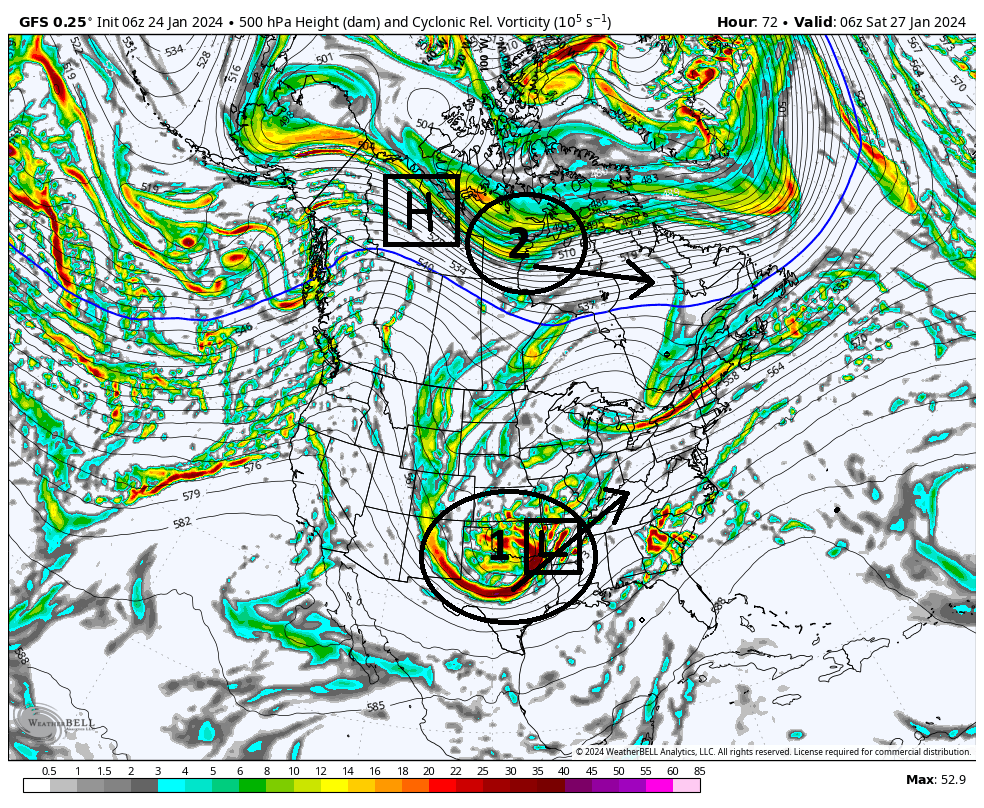
As of 6z GFS this am here is the two main energies at 500mb (18-20k ft). Labeled 1 & 2. #1 is the energy in the Pac jet which we will call the southern stream (s/s) energy and will give rise to our system, and #2 will create an arctic/polar High Pressure (HP) that will be critical for this set up for providing a cold air source.
As you can see both pieces will dig into these two approx locations by hr 72, approx 3 days from now.
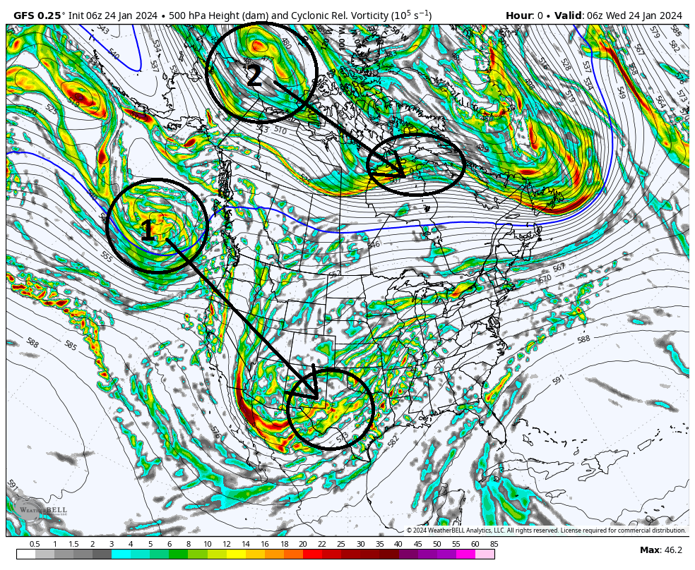
As you can now see in below image the energies are in position. From here 1 & 2 head off in the direction indicated by the arrow.
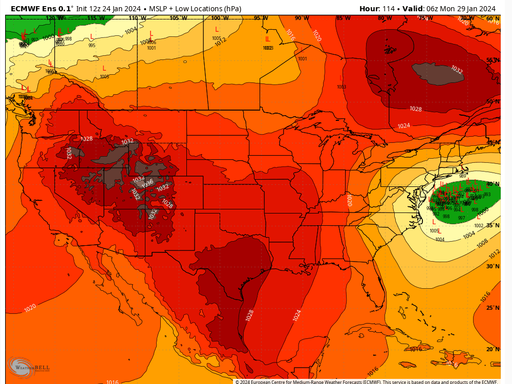
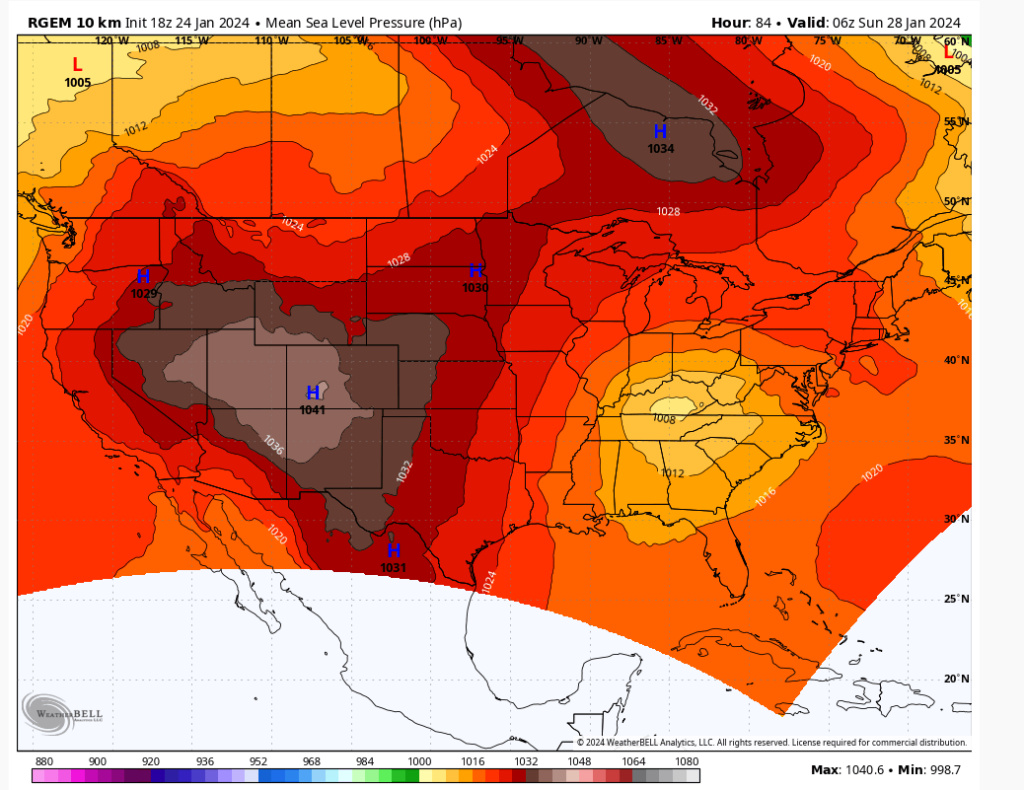
(see below) At the surface, the result of #1 is the development of a surface LP somewhere out ahead of the 500mb energy, and the result of #2 in its position is an HP developing in it's wake.
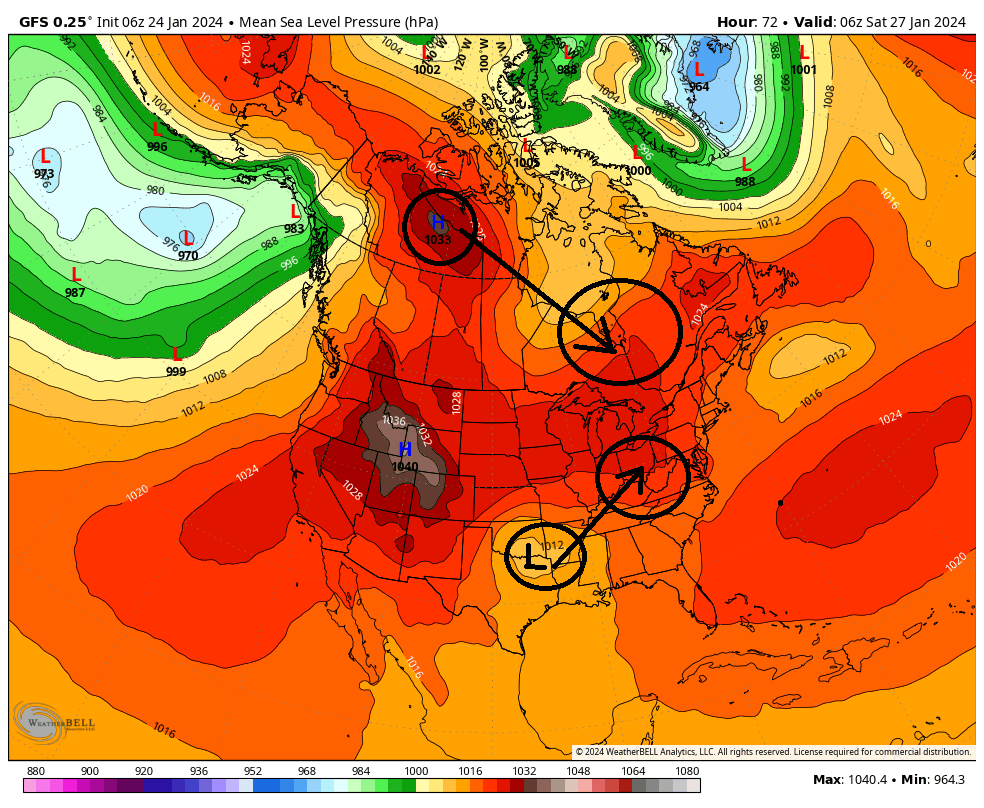
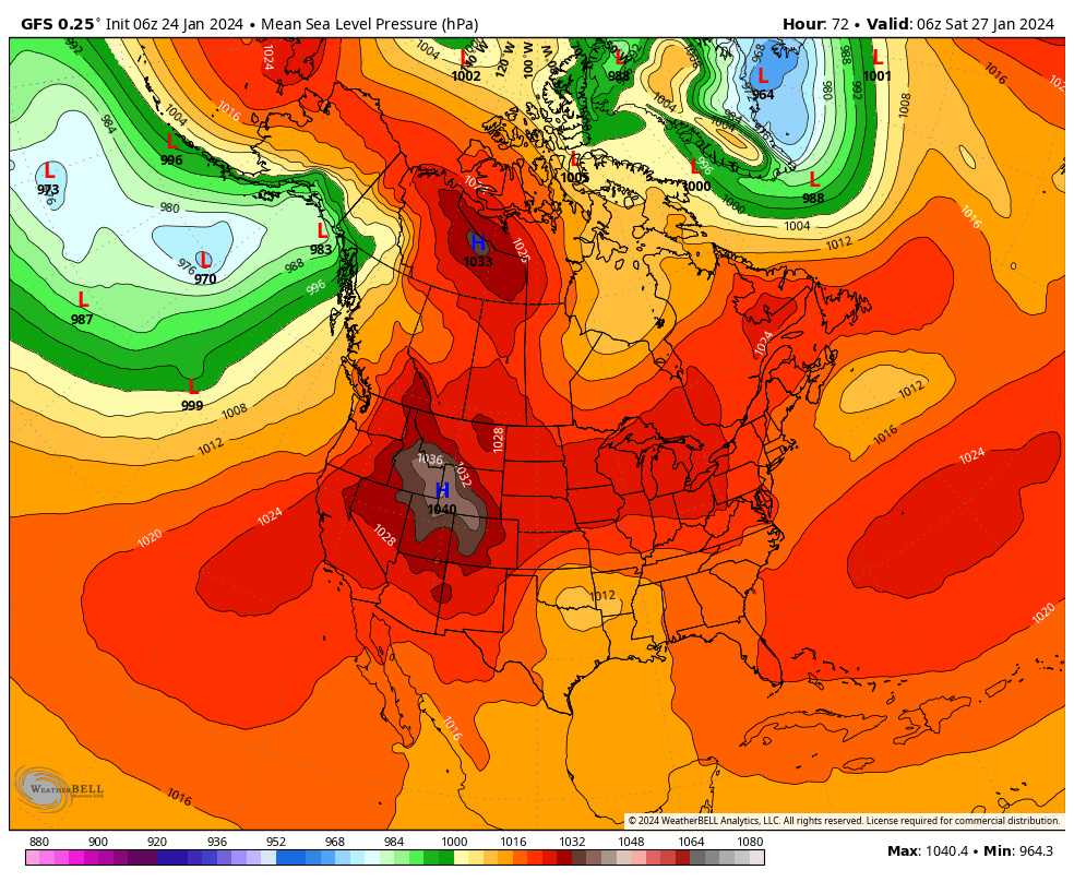
Now quickly look back at the surface map above because this becomes a critical crossroads as we move forward. The surface LP will now heads towards the Ohio/Tenn Valleys, while the HP dives into SE Canada. Simply stated, in essence the overall outcome of this potential will be dictated by the exact timing, strength, and positioning of these two main features. It becomes a race to see who can get into position first, the HP or the LP, to determine how much cold air is available, and when and where.
(Now see below) The primary LP(P LP) will cut towards the Ohio and Tenn valley. In the latest GFS run it takes the P LP north into Western Pa before transferring off the Atlantic coast, and from there the Primary deepens and heads NE.
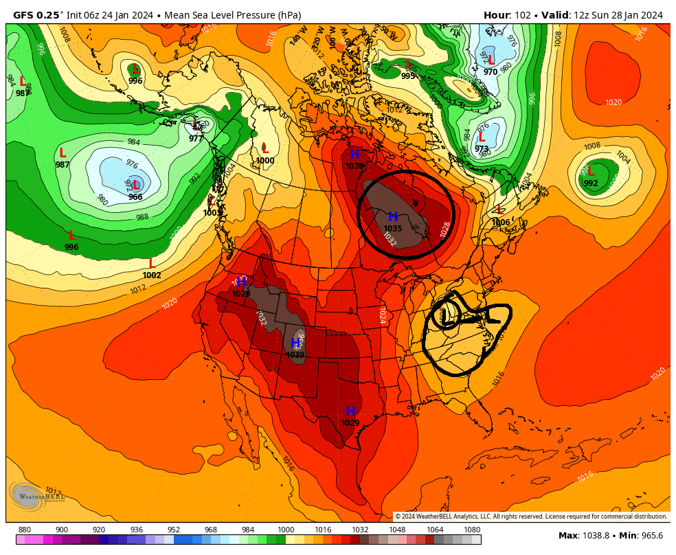
So to summerize:
1) How strong and How quickly the HP moves in to our north will dictate how far north and west our Primary LP can track before being forced to transfer to the coast.(by the way this is what a Miller B set up is...a cutting primary with a secondary LP transfer to the coast)
AND...
2) How strong and positioning of the HP also tells us how much cold air is available for the system.
CURRENTLY ON THE MODELS: ---Pay attention to HP strength ad placement---
GFS = Cuts furthest north(western PA/E Ohio) before transfer therefore secondary LP too close to the coast and only aeas furthest N&W will be cold enough to snow
CMC = Primary only makes it to W Va before transferring to the coast
Euro = notice its HP position and strength compared to GFS and CMC. Its very late to the party with the HP, but the southern energy takes a more direct route through the eastern Tenn valley, straight to the coast instead of a true Miller B where it cuts west; then transfer of energy to the coast. This will keep the coastal plain warm because of the Antecedent Air mass in place at least per 00z run verbatim.

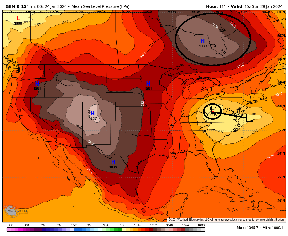

So as you can see there is still much uncertainty in the exact evolution of some of the key players. There are still big picture details that are still unclear. As we all know small changes at 500mb can have large impacts on how the surface features play out. Like pretty much any winter storm, the exact IMBY details will likely not be ironed out until within 24-48hrs.
We Track!

_________________
"In weather and in life, there's no winning and losing; there's only winning and learning."
WINTER 2012/2013 TOTALS 43.65"WINTER 2017/2018 TOTALS 62.85" WINTER 2022/2023 TOTALS 4.9"
WINTER 2013/2014 TOTALS 64.85"WINTER 2018/2019 TOTALS 14.25" WINTER 2023/2024 TOTALS 13.1"
WINTER 2014/2015 TOTALS 71.20"WINTER 2019/2020 TOTALS 6.35"
WINTER 2015/2016 TOTALS 35.00"WINTER 2020/2021 TOTALS 37.75"
WINTER 2016/2017 TOTALS 42.25"WINTER 2021/2022 TOTALS 31.65"

sroc4- Admin

- Posts : 8331
Reputation : 301
Join date : 2013-01-07
Location : Wading River, LI
aiannone, nancy-j-s, 1190ftalt, heehaw453 and Irish like this post
 Re: JAN 28th-30th 2024 Potential system compliments of a +PNA
Irish wrote:Thx for the detailed write-up, Sroc. So, if I'm reading this correctly, most likely no matter how it shakes out, the coast has a high % of an all rain event?
Irish, I hesitate to use any sort of definitive adjectives etc to describe chances for anyone particular in general, except to say that since we are in a warm phase of the MJO and the air mass leading into the weekend is less than ideal, and the pattern as a whole is less than ideal for winter weather outcomes in the north east, if you live along the coastal plain you should not expect to see white, but simultaneously understand that the chances are def not zero percent. Gun to head for my back yard on Long Island I give it <10% chance at this time. That WILL change, for better or worse, over the next 3-4 days. Off the coast percentages increase a little, but I think 50/50 is the best anyone should consider up through this am regardless of where you live.
So for me, this one will be more in the thrill of the tracking and the learning that comes along with it. If any white ends up IMBY, even if its white rain(non accumulating snow falling from the sky), I will consider that a win, given the current state of the atmosphere....again this is my current expectation.
_________________
"In weather and in life, there's no winning and losing; there's only winning and learning."
WINTER 2012/2013 TOTALS 43.65"WINTER 2017/2018 TOTALS 62.85" WINTER 2022/2023 TOTALS 4.9"
WINTER 2013/2014 TOTALS 64.85"WINTER 2018/2019 TOTALS 14.25" WINTER 2023/2024 TOTALS 13.1"
WINTER 2014/2015 TOTALS 71.20"WINTER 2019/2020 TOTALS 6.35"
WINTER 2015/2016 TOTALS 35.00"WINTER 2020/2021 TOTALS 37.75"
WINTER 2016/2017 TOTALS 42.25"WINTER 2021/2022 TOTALS 31.65"

sroc4- Admin

- Posts : 8331
Reputation : 301
Join date : 2013-01-07
Location : Wading River, LI
kalleg, nancy-j-s and Irish like this post
 Re: JAN 28th-30th 2024 Potential system compliments of a +PNA
sroc4 wrote:Irish wrote:Thx for the detailed write-up, Sroc. So, if I'm reading this correctly, most likely no matter how it shakes out, the coast has a high % of an all rain event?
Irish, I hesitate to use any sort of definitive adjectives etc to describe chances for anyone particular in general, except to say that since we are in a warm phase of the MJO and the air mass leading into the weekend is less than ideal, and the pattern as a whole is less than ideal for winter weather outcomes in the north east, if you live along the coastal plain you should not expect to see white, but simultaneously understand that the chances are def not zero percent. Gun to head for my back yard on Long Island I give it <10% chance at this time. That WILL change, for better or worse, over the next 3-4 days. Off the coast percentages increase a little, but I think 50/50 is the best anyone should consider up through this am regardless of where you live.
So for me, this one will be more in the thrill of the tracking and the learning that comes along with it. If any white ends up IMBY, even if its white rain(non accumulating snow falling from the sky), I will consider that a win, given the current state of the atmosphere....again this is my current expectation.
Couldn't agree more.
I would say I-84 and elevated areas (> 1000') of Poconos/NW NJ has 50% chance for > 3" of snow. NW I-95 50% 1-2"? Coastal plain T-1". Very rough thoughts, but the antecedent air mass is bad and we are hoping for well timed H. The issue is the stronger and faster the H the more suppressed and weak the wave.
heehaw453- Advanced Forecaster

- Posts : 3906
Reputation : 86
Join date : 2014-01-20
Location : Bedminster Township, PA Elevation 600' ASL
 Re: JAN 28th-30th 2024 Potential system compliments of a +PNA
heehaw453 wrote:sroc4 wrote:Irish wrote:Thx for the detailed write-up, Sroc. So, if I'm reading this correctly, most likely no matter how it shakes out, the coast has a high % of an all rain event?
Irish, I hesitate to use any sort of definitive adjectives etc to describe chances for anyone particular in general, except to say that since we are in a warm phase of the MJO and the air mass leading into the weekend is less than ideal, and the pattern as a whole is less than ideal for winter weather outcomes in the north east, if you live along the coastal plain you should not expect to see white, but simultaneously understand that the chances are def not zero percent. Gun to head for my back yard on Long Island I give it <10% chance at this time. That WILL change, for better or worse, over the next 3-4 days. Off the coast percentages increase a little, but I think 50/50 is the best anyone should consider up through this am regardless of where you live.
So for me, this one will be more in the thrill of the tracking and the learning that comes along with it. If any white ends up IMBY, even if its white rain(non accumulating snow falling from the sky), I will consider that a win, given the current state of the atmosphere....again this is my current expectation.
Couldn't agree more.
I would say I-84 and elevated areas (> 1000') of Poconos/NW NJ has 50% chance for > 3" of snow. NW I-95 50% 1-2"? Coastal plain T-1". Very rough thoughts, but the antecedent air mass is bad and we are hoping for well timed H. The issue is the stronger and faster the H the more suppressed and weak the wave.
Bottom line.....We need Baby bear....

_________________
"In weather and in life, there's no winning and losing; there's only winning and learning."
WINTER 2012/2013 TOTALS 43.65"WINTER 2017/2018 TOTALS 62.85" WINTER 2022/2023 TOTALS 4.9"
WINTER 2013/2014 TOTALS 64.85"WINTER 2018/2019 TOTALS 14.25" WINTER 2023/2024 TOTALS 13.1"
WINTER 2014/2015 TOTALS 71.20"WINTER 2019/2020 TOTALS 6.35"
WINTER 2015/2016 TOTALS 35.00"WINTER 2020/2021 TOTALS 37.75"
WINTER 2016/2017 TOTALS 42.25"WINTER 2021/2022 TOTALS 31.65"

sroc4- Admin

- Posts : 8331
Reputation : 301
Join date : 2013-01-07
Location : Wading River, LI
heehaw453 and SENJsnowman like this post
 Re: JAN 28th-30th 2024 Potential system compliments of a +PNA
1) There is an arctic HP pressing down and will become a factor.
2) a weak system ahead of our potential is creating some confluence in the NE
3) Cold dense air tends to win, which we have in the form of the arctic HP diving in, when its on the move like a snow plow getting under the snow
_________________
"In weather and in life, there's no winning and losing; there's only winning and learning."
WINTER 2012/2013 TOTALS 43.65"WINTER 2017/2018 TOTALS 62.85" WINTER 2022/2023 TOTALS 4.9"
WINTER 2013/2014 TOTALS 64.85"WINTER 2018/2019 TOTALS 14.25" WINTER 2023/2024 TOTALS 13.1"
WINTER 2014/2015 TOTALS 71.20"WINTER 2019/2020 TOTALS 6.35"
WINTER 2015/2016 TOTALS 35.00"WINTER 2020/2021 TOTALS 37.75"
WINTER 2016/2017 TOTALS 42.25"WINTER 2021/2022 TOTALS 31.65"

sroc4- Admin

- Posts : 8331
Reputation : 301
Join date : 2013-01-07
Location : Wading River, LI
heehaw453 likes this post
 Re: JAN 28th-30th 2024 Potential system compliments of a +PNA
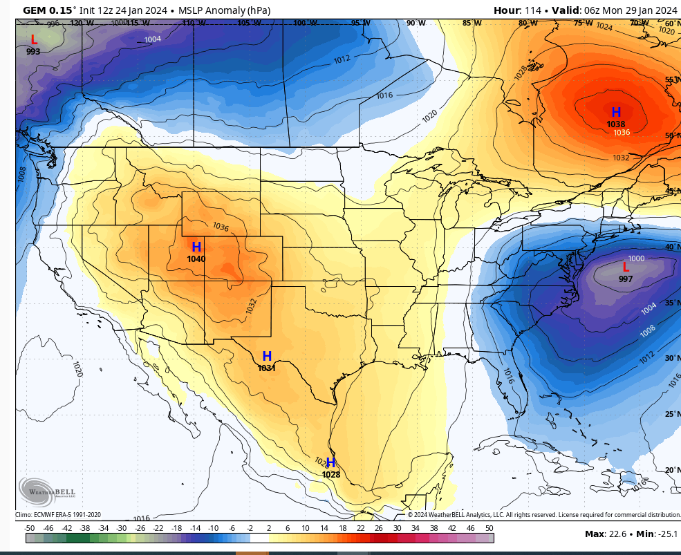
The GEM is a classic look for snowfall during end of January. Again that H emanates from the Yukon and it's got good cold air with it.
heehaw453- Advanced Forecaster

- Posts : 3906
Reputation : 86
Join date : 2014-01-20
Location : Bedminster Township, PA Elevation 600' ASL
sroc4 likes this post
 Re: JAN 28th-30th 2024 Potential system compliments of a +PNA
heehaw453 wrote:The guidance clearly is being more aggressive with the H advancing from the north. The banana signature with strong H to the north is a good setup. Albeit the antecedent is a bad one if the storm's progression is arrested soon enough (WV on south) to force redevelopment there's a possibility it gets pinned by the advancing H pressure.
The GEM is a classic look for snowfall during end of January. Again that H emanates from the Yukon and it's got good cold air with it.
Def Heehaw. And here is 18hrs earlier showing that the cmc verbatim has the primary get no further than WV, is weaker on approach, and begins its transfer to the coast near Cape Hatt

_________________
"In weather and in life, there's no winning and losing; there's only winning and learning."
WINTER 2012/2013 TOTALS 43.65"WINTER 2017/2018 TOTALS 62.85" WINTER 2022/2023 TOTALS 4.9"
WINTER 2013/2014 TOTALS 64.85"WINTER 2018/2019 TOTALS 14.25" WINTER 2023/2024 TOTALS 13.1"
WINTER 2014/2015 TOTALS 71.20"WINTER 2019/2020 TOTALS 6.35"
WINTER 2015/2016 TOTALS 35.00"WINTER 2020/2021 TOTALS 37.75"
WINTER 2016/2017 TOTALS 42.25"WINTER 2021/2022 TOTALS 31.65"

sroc4- Admin

- Posts : 8331
Reputation : 301
Join date : 2013-01-07
Location : Wading River, LI
heehaw453 likes this post
 Re: JAN 28th-30th 2024 Potential system compliments of a +PNA
heehaw453- Advanced Forecaster

- Posts : 3906
Reputation : 86
Join date : 2014-01-20
Location : Bedminster Township, PA Elevation 600' ASL
sroc4 likes this post
heehaw453- Advanced Forecaster

- Posts : 3906
Reputation : 86
Join date : 2014-01-20
Location : Bedminster Township, PA Elevation 600' ASL
sroc4, billg315 and silentwreck like this post
 Re: JAN 28th-30th 2024 Potential system compliments of a +PNA
_________________
"In weather and in life, there's no winning and losing; there's only winning and learning."
WINTER 2012/2013 TOTALS 43.65"WINTER 2017/2018 TOTALS 62.85" WINTER 2022/2023 TOTALS 4.9"
WINTER 2013/2014 TOTALS 64.85"WINTER 2018/2019 TOTALS 14.25" WINTER 2023/2024 TOTALS 13.1"
WINTER 2014/2015 TOTALS 71.20"WINTER 2019/2020 TOTALS 6.35"
WINTER 2015/2016 TOTALS 35.00"WINTER 2020/2021 TOTALS 37.75"
WINTER 2016/2017 TOTALS 42.25"WINTER 2021/2022 TOTALS 31.65"

sroc4- Admin

- Posts : 8331
Reputation : 301
Join date : 2013-01-07
Location : Wading River, LI
kalleg, essexcountypete, heehaw453, weatherwatchermom, billg315, SENJsnowman and silentwreck like this post
 Re: JAN 28th-30th 2024 Potential system compliments of a +PNA
heehaw453- Advanced Forecaster

- Posts : 3906
Reputation : 86
Join date : 2014-01-20
Location : Bedminster Township, PA Elevation 600' ASL
SENJsnowman likes this post
 Re: JAN 28th-30th 2024 Potential system compliments of a +PNA

billg315- Advanced Forecaster - Mod

- Posts : 4462
Reputation : 185
Join date : 2015-01-24
Age : 50
Location : Flemington, NJ
sroc4, amugs, crippo84, essexcountypete, heehaw453, weatherwatchermom, SENJsnowman and like this post
heehaw453- Advanced Forecaster

- Posts : 3906
Reputation : 86
Join date : 2014-01-20
Location : Bedminster Township, PA Elevation 600' ASL
weatherwatchermom and silentwreck like this post
 Re: JAN 28th-30th 2024 Potential system compliments of a +PNA

SENJsnowman- Senior Enthusiast

- Posts : 1186
Reputation : 61
Join date : 2017-01-06
Age : 51
Location : Bayville, NJ
heehaw453 likes this post
heehaw453- Advanced Forecaster

- Posts : 3906
Reputation : 86
Join date : 2014-01-20
Location : Bedminster Township, PA Elevation 600' ASL
billg315 and MattyICE like this post
 Re: JAN 28th-30th 2024 Potential system compliments of a +PNA
_________________
-Alex Iannone-

aiannone- Senior Enthusiast - Mod

- Posts : 4813
Reputation : 92
Join date : 2013-01-07
Location : Saint James, LI (Northwest Suffolk Co.)
 Re: JAN 28th-30th 2024 Potential system compliments of a +PNA
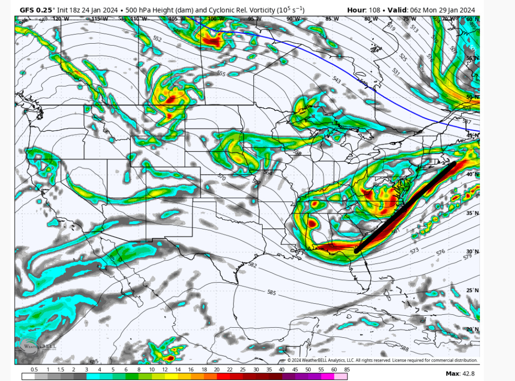
aiannone wrote:18z GFS was not enthused. Windshield wiper effect
It has a lot of the same setup it just never consolidates the energy because the h5 trough is positively tilted. The stronger solutions have a neutral tilt to help consolidate the energy. Probably just as feasible. One thing seems to be coming into focus. A strong H is going to squash heights in NNE so this storm is going more eastward than north eastward IMO.
heehaw453- Advanced Forecaster

- Posts : 3906
Reputation : 86
Join date : 2014-01-20
Location : Bedminster Township, PA Elevation 600' ASL
SENJsnowman likes this post
 Re: JAN 28th-30th 2024 Potential system compliments of a +PNA
heehaw453 wrote:aiannone wrote:18z GFS was not enthused. Windshield wiper effect
It has a lot of the same setup it just never consolidates the energy because the h5 trough is positively tilted. The stronger solutions have a neutral tilt to help consolidate the energy. Probably just as feasible. One thing seems to be coming into focus. A strong H is going to squash heights in NNE so this storm is going more eastward than north eastward IMO.
I find with miller B's the HP is always modeled too strong days before only to weaken a bit and bring the NW trend
_________________
-Alex Iannone-

aiannone- Senior Enthusiast - Mod

- Posts : 4813
Reputation : 92
Join date : 2013-01-07
Location : Saint James, LI (Northwest Suffolk Co.)
 Re: JAN 28th-30th 2024 Potential system compliments of a +PNA

Irish- Pro Enthusiast

- Posts : 788
Reputation : 19
Join date : 2019-01-16
Age : 45
Location : Old Bridge, NJ
 Re: JAN 28th-30th 2024 Potential system compliments of a +PNA
aiannone wrote:heehaw453 wrote:aiannone wrote:18z GFS was not enthused. Windshield wiper effect
It has a lot of the same setup it just never consolidates the energy because the h5 trough is positively tilted. The stronger solutions have a neutral tilt to help consolidate the energy. Probably just as feasible. One thing seems to be coming into focus. A strong H is going to squash heights in NNE so this storm is going more eastward than north eastward IMO.
I find with miller B's the HP is always modeled too strong days before only to weaken a bit and bring the NW trend
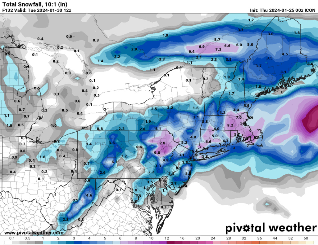
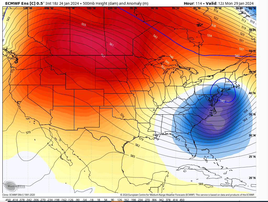
The 18Z Euro would agree with that. Weaker H and more wound up L. This is the 18Z Euro control. Closed off ULL crossing over central NJ would mean big snows in the NW interior.
IMO a split difference between GFS weak sauce and this is probably closer to what will happen because I think heights are going to be compressed enough to inhibit the h5 trough from a neutral to negative tilt. But to your point if that H is weaker and further away then this is possible.
heehaw453- Advanced Forecaster

- Posts : 3906
Reputation : 86
Join date : 2014-01-20
Location : Bedminster Township, PA Elevation 600' ASL
weatherwatchermom likes this post

aiannone- Senior Enthusiast - Mod

- Posts : 4813
Reputation : 92
Join date : 2013-01-07
Location : Saint James, LI (Northwest Suffolk Co.)
 Re: JAN 28th-30th 2024 Potential system compliments of a +PNA
We still have a long way to go with this despite it only about 3.5-4.5 days out. Its going to be really fun to be watching the transfer of the primary to the coast on the real time meso maps, and monitor the where and when and then where the mid level low closes and positions itself. I think there could be surprises both good and bad depending on where you live in real time with this one.
Buckle up folks. Tracking snow in a shitty pattern. And check your point and click apps. Notice the temp profiles beyond the weekend into next week. They aren’t that warm.
We Track.

_________________
"In weather and in life, there's no winning and losing; there's only winning and learning."
WINTER 2012/2013 TOTALS 43.65"WINTER 2017/2018 TOTALS 62.85" WINTER 2022/2023 TOTALS 4.9"
WINTER 2013/2014 TOTALS 64.85"WINTER 2018/2019 TOTALS 14.25" WINTER 2023/2024 TOTALS 13.1"
WINTER 2014/2015 TOTALS 71.20"WINTER 2019/2020 TOTALS 6.35"
WINTER 2015/2016 TOTALS 35.00"WINTER 2020/2021 TOTALS 37.75"
WINTER 2016/2017 TOTALS 42.25"WINTER 2021/2022 TOTALS 31.65"

sroc4- Admin

- Posts : 8331
Reputation : 301
Join date : 2013-01-07
Location : Wading River, LI
kalleg and SENJsnowman like this post
 Re: JAN 28th-30th 2024 Potential system compliments of a +PNA
sroc4 wrote:Not a lot changed in my mind overnight. Models continue to show decent potential for this Sunday into Monday. All the major players are there. IMO a more surpressed soln is way more likely than a primary that cuts too far north and warm soln with an arctic HP on the move the way it is.
We still have a long way to go with this despite it only about 3.5-4.5 days out. Its going to be really fun to be watching the transfer of the primary to the coast on the real time meso maps, and monitor the where and when and then where the mid level low closes and positions itself. I think there could be surprises both good and bad depending on where you live in real time with this one.
Buckle up folks. Tracking snow in a shitty pattern. And check your point and click apps. Notice the temp profiles beyond the weekend into next week. They aren’t that warm.
We Track.
I should rephrase one part. “IF the HP conts to be modeled the way it is” I can see a surpressed soln more than the cutter soln. That said I def can’t discount the idea of the HP not as strong OR ending up positioned too far north and a “warmer” soln winning out as a result. I believe Alex pointed this possibility out last night.
Again. Long way to go with this one.
_________________
"In weather and in life, there's no winning and losing; there's only winning and learning."
WINTER 2012/2013 TOTALS 43.65"WINTER 2017/2018 TOTALS 62.85" WINTER 2022/2023 TOTALS 4.9"
WINTER 2013/2014 TOTALS 64.85"WINTER 2018/2019 TOTALS 14.25" WINTER 2023/2024 TOTALS 13.1"
WINTER 2014/2015 TOTALS 71.20"WINTER 2019/2020 TOTALS 6.35"
WINTER 2015/2016 TOTALS 35.00"WINTER 2020/2021 TOTALS 37.75"
WINTER 2016/2017 TOTALS 42.25"WINTER 2021/2022 TOTALS 31.65"

sroc4- Admin

- Posts : 8331
Reputation : 301
Join date : 2013-01-07
Location : Wading River, LI
kalleg likes this post
 Re: JAN 28th-30th 2024 Potential system compliments of a +PNA
The transfer to the coast is always a tricky one. Is the secondary too close to the coast? Who suffers from the dreaded area of subsidence? Exactly how deep can the secondary get to pull colder air down to the coast? These are the main questions that enter my mind.
Models are conflicted as they try to solve these questions. We definitely have a long way to go. Gun to my head, based on this seasons trend, N&W should do well again. A nice moderate snowfall possibly. Unfortunately I think the coast will roast. Temps will be in the 50s leading up to the event, and the ULL won’t be south enough to drag in the cold air from the north. MAYBE a minor accumulation on the table. Hope I’m wrong. But at least it’s something to track
_________________
_______________________________________________________________________________________________________
CLICK HERE to view NJ Strong Snowstorm Classifications
SENJsnowman and MattyICE like this post
 Re: JAN 28th-30th 2024 Potential system compliments of a +PNA
"Coast will roast"! Great phrase, though a sad prediction indeed...Frank_Wx wrote:Agreed Scott…pleasantly surprised we’re even talking snow. But good things happen when you get a well timed PNA spike. I wish for northern stream interaction but I think I need to eliminate this idea from my mind. El Niño is going to Nino.
The transfer to the coast is always a tricky one. Is the secondary too close to the coast? Who suffers from the dreaded area of subsidence? Exactly how deep can the secondary get to pull colder air down to the coast? These are the main questions that enter my mind.
Models are conflicted as they try to solve these questions. We definitely have a long way to go. Gun to my head, based on this seasons trend, N&W should do well again. A nice moderate snowfall possibly. Unfortunately I think the coast will roast. Temps will be in the 50s leading up to the event, and the ULL won’t be south enough to drag in the cold air from the north. MAYBE a minor accumulation on the table. Hope I’m wrong. But at least it’s something to track
kalleg- Posts : 142
Reputation : 2
Join date : 2013-01-15
Location : New Hope, PA
Page 1 of 5 • 1, 2, 3, 4, 5 
|
|
|

 Home
Home


