Long Range Thread 28.0
Page 2 of 18 •  1, 2, 3 ... 10 ... 18
 Re: Long Range Thread 28.0
SENJsnowman wrote:Looked to me that at 06z the NAM and the RGEM both show a bit more of a robust system than the other models. But they still were in 1-3” range generally with an add’l inch or two across central and southern Jersey. Definitely shows the potential to get a bigger final result, but one definition of potential is “hasn’t done it yet.”
Today is a big tracking day…sorry boss!! I’ll pick up the pace again next week! But today, we track!
You have an ULL sliding underneath the area. That in and of itself can cause surprises if it can close off before hitting coasty. Seen is way too many times over the years especially with a bottlenecked Atlantic. I think though 1-3" is an excellent expectations setter for now.
heehaw453- Advanced Forecaster

- Posts : 3906
Join date : 2014-01-20
SENJsnowman likes this post
 Re: Long Range Thread 28.0

jmanley32- Senior Enthusiast

- Posts : 20516
Reputation : 108
Join date : 2013-12-12
Age : 42
Location : Yonkers, NY
 Re: Long Range Thread 28.0
jmanley32 wrote:I imagine people are busy but the lack of posts about fri concerns me. Nam had a good precip field but really only benefit southern jersey with 3 to 6. Hoping we can all cash in at least along coast. Anyone seeing this moving in a positive direction?
It will all depends upon where the inverted trough sets up, the folks in that area should do well and right now it looks more like southern NJ
phil155- Pro Enthusiast

- Posts : 475
Reputation : 4
Join date : 2019-12-16
SENJsnowman likes this post
 Re: Long Range Thread 28.0
so a coastal is off the table?phil155 wrote:jmanley32 wrote:I imagine people are busy but the lack of posts about fri concerns me. Nam had a good precip field but really only benefit southern jersey with 3 to 6. Hoping we can all cash in at least along coast. Anyone seeing this moving in a positive direction?
It will all depends upon where the inverted trough sets up, the folks in that area should do well and right now it looks more like southern NJ

jmanley32- Senior Enthusiast

- Posts : 20516
Reputation : 108
Join date : 2013-12-12
Age : 42
Location : Yonkers, NY
 Re: Long Range Thread 28.0
jmanley32 wrote:so a coastal is off the table?phil155 wrote:jmanley32 wrote:I imagine people are busy but the lack of posts about fri concerns me. Nam had a good precip field but really only benefit southern jersey with 3 to 6. Hoping we can all cash in at least along coast. Anyone seeing this moving in a positive direction?
It will all depends upon where the inverted trough sets up, the folks in that area should do well and right now it looks more like southern NJ
Check the Jan Observations and Discussions thread.

crippo84- Posts : 383
Reputation : 20
Join date : 2013-11-07
Age : 40
Location : East Village, NYC
jmanley32 likes this post
 Re: Long Range Thread 28.0
_________________
_______________________________________________________________________________________________________
CLICK HERE to view NJ Strong Snowstorm Classifications
 Re: Long Range Thread 28.0
Frank_Wx wrote:So…uhh I think we may all need to go into hibernation for a couple of weeks based on latest long range projections
I think it might help if you create specific thread dedicated to the overly sensible weather.

Grselig- Senior Enthusiast

- Posts : 1408
Reputation : 140
Join date : 2013-03-04
Age : 54
Location : Wayne NJ
kalleg and crippo84 like this post
 Re: Long Range Thread 28.0
Frank_Wx wrote:So…uhh I think we may all need to go into hibernation for a couple of weeks based on latest long range projections
I respectfully disagree, Frank. I think that we are going to be in a very active, pseudo-gradient pattern overall starting next week and going through February, and then I think the last week of February through March features an overall better pattern. During the gradient pattern, I think we will be very close to the R/S line, though biased on the cold side.
I’ll elaborate more in the next day or two, but I’m actually kind of optimistic. Gradient patterns can produce in a big way, as long as you’re on the right/cold side of them.
rb924119- Meteorologist

- Posts : 6890
Reputation : 194
Join date : 2013-02-06
Age : 32
Location : Greentown, Pa
kalleg, Grselig and dolphins222 like this post
 Re: Long Range Thread 28.0
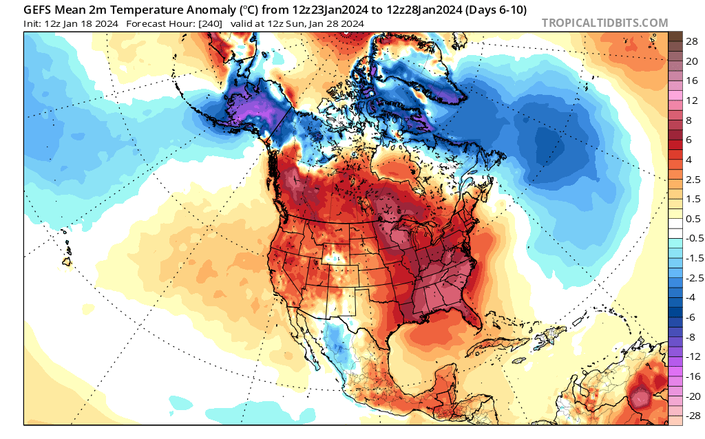
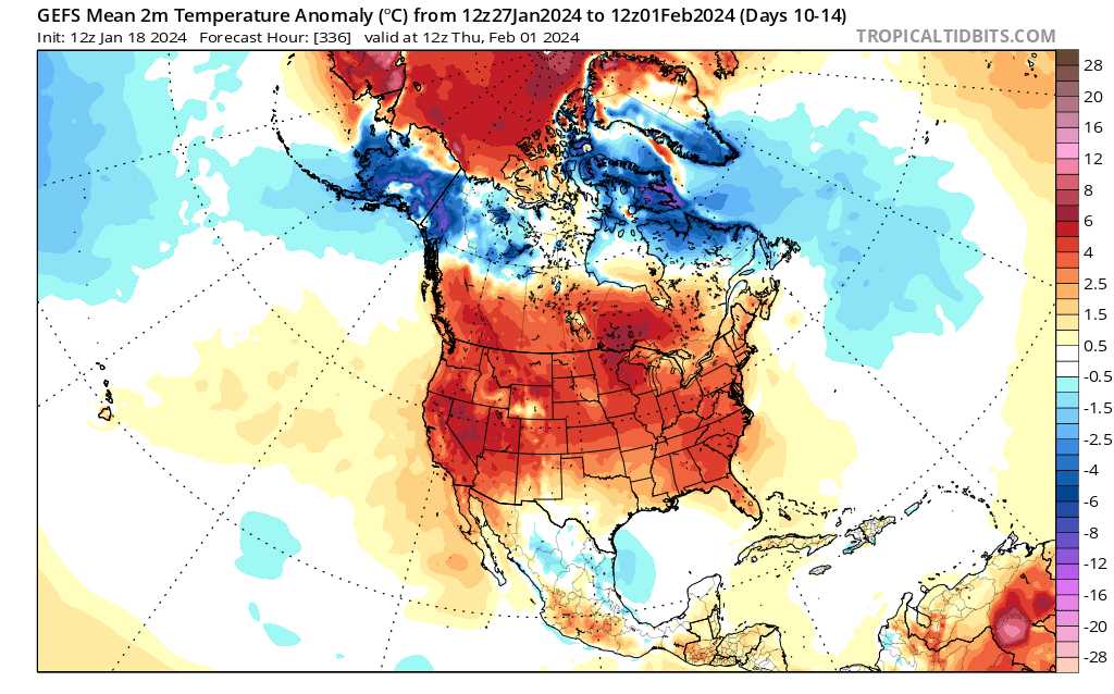
250mb shows another pacific jet extension during this time, and an MJO in phases 5-6 which favors a trough west of us.
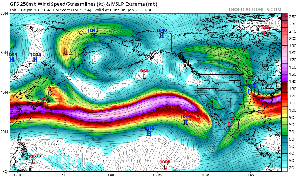
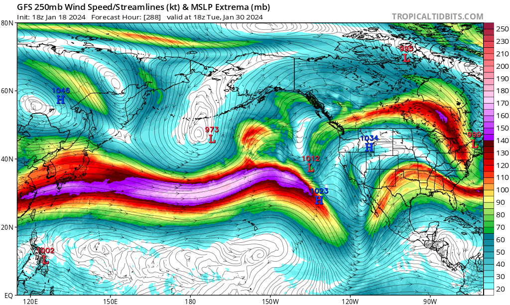
I have a feeling outside of N&W area / elevation, the gradient is going to be unfavorable to many. I’m only talking about the next two weeks. Beyond let’s say Feb 1st I haven’t given it much thought, so hopefully you’re onto something. But if we have to wait until the end of February I’m going to be pissed
_________________
_______________________________________________________________________________________________________
CLICK HERE to view NJ Strong Snowstorm Classifications
kalleg, heehaw453, weatherwatchermom and SENJsnowman like this post
 Re: Long Range Thread 28.0
_________________
Mugs
AKA:King: Snow Weenie
Self Proclaimed
WINTER 2014-15 : 55.12" +.02 for 6 coatings (avg. 35")
WINTER 2015-16 Total - 29.8" (Avg 35")
WINTER 2016-17 : 39.5" so far

amugs- Advanced Forecaster - Mod

- Posts : 15093
Reputation : 213
Join date : 2013-01-07
Age : 54
Location : Hillsdale,NJ
 Re: Long Range Thread 28.0
I am thinking February is the time when there is "that storm" potential. You looks at historical El Nino's and February 1-15th is usually when it occurs.

heehaw453- Advanced Forecaster

- Posts : 3906
Reputation : 86
Join date : 2014-01-20
Location : Bedminster Township, PA Elevation 600' ASL
billg315 likes this post
 Re: Long Range Thread 28.0
As I said before, the MJO seems to have improved tonight. It drops slightly due to the U850 winds, but the combined one isn't bad.
— Christian (@Superchri90) January 19, 2024
You can also see in the ECMWF averages how the divergence and convergence between soil and altitude is not synchronous, a sign of weakness! pic.twitter.com/IIWKITnLnd
Interesting information and take on MJO.
Weaker phases wave are better so it's not a torch like 50's but more upper 30's to 40ish. You can work with this if you get the timing for a storm
_________________
Mugs
AKA:King: Snow Weenie
Self Proclaimed
WINTER 2014-15 : 55.12" +.02 for 6 coatings (avg. 35")
WINTER 2015-16 Total - 29.8" (Avg 35")
WINTER 2016-17 : 39.5" so far

amugs- Advanced Forecaster - Mod

- Posts : 15093
Reputation : 213
Join date : 2013-01-07
Age : 54
Location : Hillsdale,NJ
 Re: Long Range Thread 28.0

jmanley32- Senior Enthusiast

- Posts : 20516
Reputation : 108
Join date : 2013-12-12
Age : 42
Location : Yonkers, NY
 Re: Long Range Thread 28.0
jmanley32 wrote:Any thoughts on the time period showing a coastal on 18z GFS around Jan 29th. Would this be a favorable time for a storm? I know this could easily be a LR blip and it verbatim shows rain for most except far inland but does the period support a possible storm? Looks like not much or nothing at all to track until the end of Jan, am I correct?
I think it may be break time from tracking for many. Just quickly looking at the ensembles today there is a robust positive PNA ridge. This might be enough to produce. Give it a few days.
_________________
"In weather and in life, there's no winning and losing; there's only winning and learning."
WINTER 2012/2013 TOTALS 43.65"WINTER 2017/2018 TOTALS 62.85" WINTER 2022/2023 TOTALS 4.9"
WINTER 2013/2014 TOTALS 64.85"WINTER 2018/2019 TOTALS 14.25" WINTER 2023/2024 TOTALS 13.1"
WINTER 2014/2015 TOTALS 71.20"WINTER 2019/2020 TOTALS 6.35"
WINTER 2015/2016 TOTALS 35.00"WINTER 2020/2021 TOTALS 37.75"
WINTER 2016/2017 TOTALS 42.25"WINTER 2021/2022 TOTALS 31.65"

sroc4- Admin

- Posts : 8331
Reputation : 301
Join date : 2013-01-07
Location : Wading River, LI
jmanley32 and MattyICE like this post
 Re: Long Range Thread 28.0
Jet streak undercuts the block.
— ContentWeatherGuy (@ContentWxGuy) January 20, 2024
The west to east pancaked elongated cells also leave little wiggle room for storm systems to come together in time. pic.twitter.com/yh3vKxH3ca
_________________
Mugs
AKA:King: Snow Weenie
Self Proclaimed
WINTER 2014-15 : 55.12" +.02 for 6 coatings (avg. 35")
WINTER 2015-16 Total - 29.8" (Avg 35")
WINTER 2016-17 : 39.5" so far

amugs- Advanced Forecaster - Mod

- Posts : 15093
Reputation : 213
Join date : 2013-01-07
Age : 54
Location : Hillsdale,NJ
 Re: Long Range Thread 28.0
toople- Posts : 67
Reputation : 0
Join date : 2015-01-01
Location : Nutley, NJ
 Re: Long Range Thread 28.0

heehaw453- Advanced Forecaster

- Posts : 3906
Reputation : 86
Join date : 2014-01-20
Location : Bedminster Township, PA Elevation 600' ASL
sroc4 and kalleg like this post
 Re: Long Range Thread 28.0
Unfortunately we do appear like we are headed into a period that could be considered the "January Thaw", a period of time that can last a week or two give or take that results with the atmosphere rebounding a bit after an arctic intrusion. By about Tuesday or Wednesday of this week we likely go back to an above normal temp regime.
In general the "thaw" looks to last through at least Feb 5th-7th ish, at least that's the way it appears to me at the moment, before the pattern looks to reload again to one that features more high latitude blocking in the EPO, NAO and AO domains, which will bring the polar and arctic air masses back to the region. The details of this; however, are still fuzzy so for now it does appears that from a distance there is still plenty of winter left, but we are going to have to take one on the chin for the next couple/few weeks.
Now with all that said there is a small window of opportunity IMHO right out in front of us that could produce some wintery weather for our little weather weenie community somewhere between the time frame of Jan 28th-31st. Even though the EPO is going positive; the AO and NAO are also going positive during the next couple of weeks at least, the PNA is headed towards a robust positive phase during this window outlined.

I know many of you know this, but for those who are new to the board and to weather, a +PNA places a ridge along the west coast of the US and Canada. While this ridge will cause Canada to be well above normal, esp the western half of Canada, this ridge also prevents the Continental US(CONUS) from being directly flooded by the warm Pacific air mass. By taking the jet stream north into the northern latitudes the warm Pac air now has the opportunity to mix and be diluted by the much colder Canadian air mass. As it dips south again what we have access to in regards to "air mass" is what we would term "modified Pacific air". Early on in the season, esp when there is no snow pack in Canada, this really isn't cold enough to do much for us in terms of cold enough to snow in most instances. However, the later we head into the season means that the eastern half of Canada has had the opportunity to build a snow pack, and lower its temps such that is has more potent diluting of warm Pac air power.
What am I getting at? Well during time frame between Jan 28th-31st if we have well timed energy coming out of both southern and northern branches, the +PNA, could produce because this late in the season with a Canadian snow pack, if we get a storm to develop into the mid Atlantic and north east, the air mass to our immediate north should be "cold enough" to work with. Storm potential is usually somewhat limited. Meaning don't expect opportunities to see feet, but a light to moderate event is def doable this time of year with a +PNA.
Here are the latest GEFS and EPS showing what Im saying. Sorry its maybe a little more busy that it needed to be, but I think highlights what I said above with a visual.

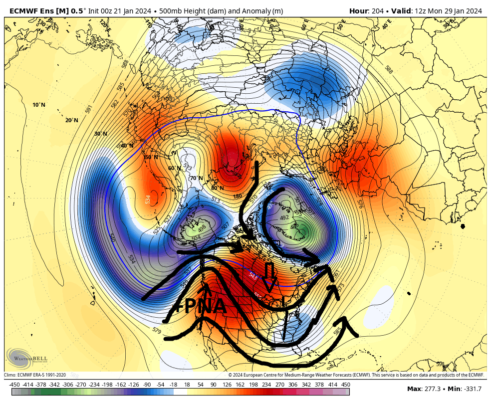
So we still have a week to ten days for this. As we head towards next weekend is when I personally will start looking at operational runs with any seriousness for this time frame. Just remember this is during the "THAW". Any chances we get between now and Feb 7th is a cherry IMO. Temper expectations but know there may be an opportunity out there before we head back to a more favorable pattern overall for the final few weeks of February.
We track

Last edited by sroc4 on Sun Jan 21, 2024 9:26 am; edited 1 time in total
_________________
"In weather and in life, there's no winning and losing; there's only winning and learning."
WINTER 2012/2013 TOTALS 43.65"WINTER 2017/2018 TOTALS 62.85" WINTER 2022/2023 TOTALS 4.9"
WINTER 2013/2014 TOTALS 64.85"WINTER 2018/2019 TOTALS 14.25" WINTER 2023/2024 TOTALS 13.1"
WINTER 2014/2015 TOTALS 71.20"WINTER 2019/2020 TOTALS 6.35"
WINTER 2015/2016 TOTALS 35.00"WINTER 2020/2021 TOTALS 37.75"
WINTER 2016/2017 TOTALS 42.25"WINTER 2021/2022 TOTALS 31.65"

sroc4- Admin

- Posts : 8331
Reputation : 301
Join date : 2013-01-07
Location : Wading River, LI
kalleg, Grselig and SENJsnowman like this post
 Re: Long Range Thread 28.0
heehaw453 wrote:Frank's scroll mentions it, but that 1/28 period synoptically is workable especially for the interior. The AO/EPO are not right for sig snows on the coastal plain. The interior is not as sensitive to that so much better chance for a few to several inches. Before that on 1/24 could be some minor/moderate icing in the interior.
I popped that up there this morning Heehaw. The scroll that is. And obv as you were posting yours I was writing mine up too. As usual you and I both seem to be on the same page here with the big picture. Well see.
_________________
"In weather and in life, there's no winning and losing; there's only winning and learning."
WINTER 2012/2013 TOTALS 43.65"WINTER 2017/2018 TOTALS 62.85" WINTER 2022/2023 TOTALS 4.9"
WINTER 2013/2014 TOTALS 64.85"WINTER 2018/2019 TOTALS 14.25" WINTER 2023/2024 TOTALS 13.1"
WINTER 2014/2015 TOTALS 71.20"WINTER 2019/2020 TOTALS 6.35"
WINTER 2015/2016 TOTALS 35.00"WINTER 2020/2021 TOTALS 37.75"
WINTER 2016/2017 TOTALS 42.25"WINTER 2021/2022 TOTALS 31.65"

sroc4- Admin

- Posts : 8331
Reputation : 301
Join date : 2013-01-07
Location : Wading River, LI
docstox12, kalleg, Grselig, heehaw453 and MattyICE like this post
 Re: Long Range Thread 28.0
Something like 12Z Euro today too strong on the s/w and would be rain as it's too close to coast.
I do like the setup with fast approaching H helping wedge cold air down. Much better than retreating H off the coast.

heehaw453- Advanced Forecaster

- Posts : 3906
Reputation : 86
Join date : 2014-01-20
Location : Bedminster Township, PA Elevation 600' ASL
kalleg likes this post
 Re: Long Range Thread 28.0
heehaw453 wrote:Confidence is growing a storm is coming on 1/29. Whether it produces snow is probably dependent on the strength/speed of the H to the north and the initial s/w strength. Both are just too far out to have any confidence yet.
Something like 12Z Euro today too strong on the s/w and would be rain as it's too close to coast.
I do like the setup with fast approaching H helping wedge cold air down. Much better than retreating H off the coast.
Absolutely, timing is crucial to this one.
_________________
Mugs
AKA:King: Snow Weenie
Self Proclaimed
WINTER 2014-15 : 55.12" +.02 for 6 coatings (avg. 35")
WINTER 2015-16 Total - 29.8" (Avg 35")
WINTER 2016-17 : 39.5" so far

amugs- Advanced Forecaster - Mod

- Posts : 15093
Reputation : 213
Join date : 2013-01-07
Age : 54
Location : Hillsdale,NJ
kalleg likes this post
 Re: Long Range Thread 28.0
heehaw453 wrote:Confidence is growing a storm is coming on 1/29. Whether it produces snow is probably dependent on the strength/speed of the H to the north and the initial s/w strength. Both are just too far out to have any confidence yet.
Something like 12Z Euro today too strong on the s/w and would be rain as it's too close to coast.
I do like the setup with fast approaching H helping wedge cold air down. Much better than retreating H off the coast.
Yeah Euro seemed to be a Miller B that transferred too late. Timing, position, and orientation of the PNA ridge will be critical as well. Signal is there though
_________________
"In weather and in life, there's no winning and losing; there's only winning and learning."
WINTER 2012/2013 TOTALS 43.65"WINTER 2017/2018 TOTALS 62.85" WINTER 2022/2023 TOTALS 4.9"
WINTER 2013/2014 TOTALS 64.85"WINTER 2018/2019 TOTALS 14.25" WINTER 2023/2024 TOTALS 13.1"
WINTER 2014/2015 TOTALS 71.20"WINTER 2019/2020 TOTALS 6.35"
WINTER 2015/2016 TOTALS 35.00"WINTER 2020/2021 TOTALS 37.75"
WINTER 2016/2017 TOTALS 42.25"WINTER 2021/2022 TOTALS 31.65"

sroc4- Admin

- Posts : 8331
Reputation : 301
Join date : 2013-01-07
Location : Wading River, LI
2004blackwrx and kalleg like this post
 Re: Long Range Thread 28.0
sroc4 wrote:heehaw453 wrote:Confidence is growing a storm is coming on 1/29. Whether it produces snow is probably dependent on the strength/speed of the H to the north and the initial s/w strength. Both are just too far out to have any confidence yet.
Something like 12Z Euro today too strong on the s/w and would be rain as it's too close to coast.
I do like the setup with fast approaching H helping wedge cold air down. Much better than retreating H off the coast.
Yeah Euro seemed to be a Miller B that transferred too late. Timing, position, and orientation of the PNA ridge will be critical as well. Signal is there though
100%. I've seen worse set ups than this produce in peak climo. I'm somewhat optimistic for now because I'm a sucker for banana H.
heehaw453- Advanced Forecaster

- Posts : 3906
Reputation : 86
Join date : 2014-01-20
Location : Bedminster Township, PA Elevation 600' ASL
sroc4, kalleg and MattyICE like this post
 Re: Long Range Thread 28.0
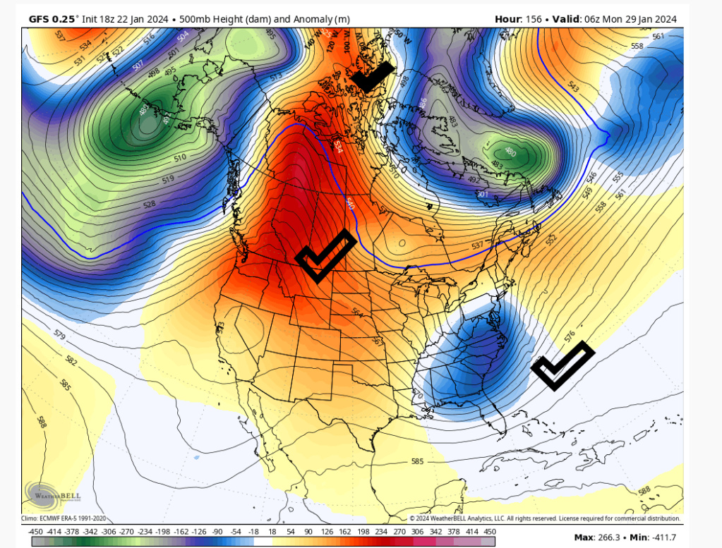
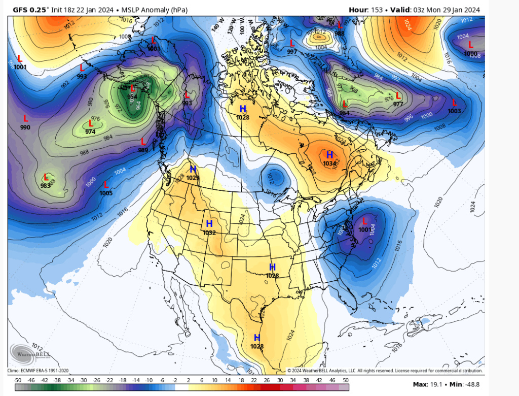
The H is coming right out the Yukon compliments of the PNA/AO. We shall see.
heehaw453- Advanced Forecaster

- Posts : 3906
Reputation : 86
Join date : 2014-01-20
Location : Bedminster Township, PA Elevation 600' ASL
sroc4, kalleg and MattyICE like this post
 Re: Long Range Thread 28.0
heehaw453 wrote:This is op model GFS 18Z. That's how it snows in January during a marginal long wave pattern. The PNA can overcome quite a bit as the AO is not hostile as shown. NYC and the coastal plain absolutely can have a moderate event with a neutral AO and positive PNA in late January.
The H is coming right out the Yukon compliments of the PNA/AO. We shall see.
Here I was, all ready to step away for a week or two (albeit half-heartedly) for a little set break, when the long range crew basically comes right back on stage, plugs right back in and starts jamming again!
I guess I’m nothing but a tracker. From mid-November to mid-March tracking Wall and Wing (fka winter) storms in the Mid-Atlantic/Northeast is all I know. I might need a 12 step intervention, but yet I’m clearly not ready for that at this time, so I’m just going to track.
 Who’s with me?
SENJsnowman- Senior Enthusiast

- Posts : 1186
Reputation : 61
Join date : 2017-01-06
Age : 51
Location : Bayville, NJ
kalleg, dkodgis and weatherwatchermom like this post
 Re: Long Range Thread 28.0
heehaw453 wrote:sroc4 wrote:heehaw453 wrote:Confidence is growing a storm is coming on 1/29. Whether it produces snow is probably dependent on the strength/speed of the H to the north and the initial s/w strength. Both are just too far out to have any confidence yet.
Something like 12Z Euro today too strong on the s/w and would be rain as it's too close to coast.
I do like the setup with fast approaching H helping wedge cold air down. Much better than retreating H off the coast.
Yeah Euro seemed to be a Miller B that transferred too late. Timing, position, and orientation of the PNA ridge will be critical as well. Signal is there though
100%. I've seen worse set ups than this produce in peak climo. I'm somewhat optimistic for now because I'm a sucker for banana H.
Ugh. I go weak for banana highs. <3
MattyICE- Advanced Forecaster

- Posts : 249
Reputation : 6
Join date : 2017-11-10
Age : 38
Location : Clifton, NJ (Eastern Passaic County)
dkodgis and heehaw453 like this post
Page 2 of 18 •  1, 2, 3 ... 10 ... 18
|
|
|

 Home
Home