
 Search
FEB 13th Pre V-Day Storm Part II
Page 3 of 15 •  1, 2, 3, 4 ... 9 ... 15
 ![]()
Re: FEB 13th Pre V-Day Storm Part II
![]() by Goalscore1 Mon Feb 12, 2024 7:29 pm
by Goalscore1 Mon Feb 12, 2024 7:29 pm
Goalscore1- Posts : 11
Join date : 2024-01-16
Frank_Wx- Godzilla Seeker

- Posts : 21305
Join date : 2013-01-05 -

jmanley32 likes this post
Re: FEB 13th Pre V-Day Storm Part II
![]() by docstox12 Mon Feb 12, 2024 7:34 pm
by docstox12 Mon Feb 12, 2024 7:34 pm

docstox12- Wx Statistician Guru

- Posts : 8502
Reputation : 222
Join date : 2013-01-07
Age : 73
Location : Monroe NY
Dunnzoo and jmanley32 like this post
Re: FEB 13th Pre V-Day Storm Part II
![]() by jmanley32 Mon Feb 12, 2024 7:37 pm
by jmanley32 Mon Feb 12, 2024 7:37 pm

jmanley32- Senior Enthusiast

- Posts : 20513
Reputation : 108
Join date : 2013-12-12
Age : 42
Location : Yonkers, NY
Re: FEB 13th Pre V-Day Storm Part II
![]() by Frank_Wx Mon Feb 12, 2024 7:48 pm
by Frank_Wx Mon Feb 12, 2024 7:48 pm
jmanley32 wrote:The GFS was not great either (better than Euro), I am hoping the Super SR models are right, why bother sending recon out? So it can have sampling for 06z? It will be on the doorstep by then. I actually may stay up tonight for all but Euro, I am going with Bernie, gutsy or not.
The data will be ingested into tonight’s 00z runs
_________________
_______________________________________________________________________________________________________
CLICK HERE to view NJ Strong Snowstorm Classifications

Frank_Wx- Godzilla Seeker
- Posts : 21305
Reputation : 328
Join date : 2013-01-05
Age : 31
Location : Jersey City, NJ -
jmanley32 likes this post
Re: FEB 13th Pre V-Day Storm Part II
![]() by Goalscore1 Mon Feb 12, 2024 7:49 pm
by Goalscore1 Mon Feb 12, 2024 7:49 pm
Goalscore1- Posts : 11
Reputation : 0
Join date : 2024-01-16
Re: FEB 13th Pre V-Day Storm Part II
![]() by Frank_Wx Mon Feb 12, 2024 7:55 pm
by Frank_Wx Mon Feb 12, 2024 7:55 pm
Goalscore1 wrote:What’s the rain/snow line looking like?
Not a concern unless there’s a dramatic shift back to the north. Doubtful
_________________
_______________________________________________________________________________________________________
CLICK HERE to view NJ Strong Snowstorm Classifications
Frank_Wx- Godzilla Seeker
- Posts : 21305
Reputation : 328
Join date : 2013-01-05
Age : 31
Location : Jersey City, NJ -
Re: FEB 13th Pre V-Day Storm Part II
![]() by jmanley32 Mon Feb 12, 2024 8:04 pm
by jmanley32 Mon Feb 12, 2024 8:04 pm
Heavy Snowfall-Winter Storm Warning for entire area late Tonight into Tuesday Interior NE NJ, interior Lower Hudson Valley, interior SW CT: Heavy, wet snow late tonight into early Tue aft. Total Snowfall: 6 to10” likely, with reasonable worst case of 12 to 15” late tonight into midday Tue. Snowfall Rates: 1-2+“/hrpossible btwn5am and noon (2 hrslater for eastern areas) Temps: Upper 20s during snowfall, lower 30s Tue aft, lower/mid 20s Tue Night. Winds: NE-N winds 15 mph with gusts 25 mph Tue Am/PM Impacts: ¼ to ½ mile vsby, snow covered roads and difficult travel late tonight through Tue aft. Scattered downed tree branches w/ isolated power outages from snow load. Portions of NE NJ, Southern Westchester, much of S CT: Rain transition to heavy, wet snow early Tue AM into early Tue aft. Total Snowfall: 8 to 11” likely, with reasonable worst case of 12 to 15” late tonight into intomid aft Tue. Snowfall Rates: 1-2+“/hrpossible btwn5am and noon (2 hrslater for eastern areas) Temps: Mid 30s tonight, lower 30s during snowfall and Tue aft, upper 20s Tue Night. Winds: NE-N winds 15-20 mph with gusts 25 to 30 mph Tue Am/PM Impacts: ¼ to ½ mile vsby, snow covered roads and difficult travel late tonight through Tue aft. Scattered downed tree branches w/ isolated power outages from snow load. NYC metro and Long Island: Rain transition to Heavy, wet snow around daybreak Tue into early Tue aft. Total Snowfall: 6 to 10” likely, with reasonable worst case of 10-12”, early Tue AM into mid aft Tue. Snowfall Rates: 1-2+“/hrpossible btwn5am and noon (2 hrslater for eastern areas) Temps: Upper 30s tonight, around 32F during snowfall, mid 30s Tue aft/eve, lower 30s Tue night. Winds: NE-N winds 20-25 mph with gusts 35 to 40 mph Tue Am/PM, highest east. Impacts: ¼ to ½ mile vsby, snow covered roads and difficult travel Tue AM into Tue aft. Scattered downed tree branches w/ isolated power outages from snow load.
jmanley32- Senior Enthusiast
- Posts : 20513
Reputation : 108
Join date : 2013-12-12
Age : 42
Location : Yonkers, NY
CPcantmeasuresnow likes this post
Re: FEB 13th Pre V-Day Storm Part II
![]() by Irish Mon Feb 12, 2024 8:09 pm
by Irish Mon Feb 12, 2024 8:09 pm
Make preparations per the instructions
Issued By
Philadelphia - PA, US, National Weather Service
Affected Area
In New Jersey, Middlesex, Western Monmouth and Mercer. In Pennsylvania, Lower Bucks
Description
...WINTER STORM WARNING IN EFFECT FROM MIDNIGHT TONIGHT TO 3 PM EST TUESDAY...
WHAT...Heavy snow expected. Total snow accumulations of 4 to 7 inches. Winds gusting as high as 40 mph.
WHERE...In New Jersey, Middlesex, Western Monmouth and Mercer. In Pennsylvania, Lower Bucks.
WHEN...From midnight tonight to 3 PM EST Tuesday.
IMPACTS...Travel could be very difficult. The hazardous conditions could impact the morning commute.
ADDITIONAL DETAILS...Briefly heavy snow will be possible around the time of the morning commute, with snowfall rates of up to 1 inch per hour possible. There is uncertainty regarding snow amounts and how efficiently the snow will accumulate on roads, given mild temperatures with precipitation starting as rain overnight.
PRECAUTIONARY/PREPAREDNESS ACTIONS...
If you must travel, keep an extra flashlight, food, and water in your vehicle in case of an emergency.
The latest road conditions for the state you are calling from can be obtained by calling 5 1 1.

Irish- Pro Enthusiast

- Posts : 788
Reputation : 19
Join date : 2019-01-16
Age : 45
Location : Old Bridge, NJ
CPcantmeasuresnow, kalleg, jmanley32 and phil155 like this post
Re: FEB 13th Pre V-Day Storm Part II
![]() by billg315 Mon Feb 12, 2024 8:29 pm
by billg315 Mon Feb 12, 2024 8:29 pm


billg315- Advanced Forecaster - Mod

- Posts : 4462
Reputation : 185
Join date : 2015-01-24
Age : 50
Location : Flemington, NJ


billg315- Advanced Forecaster - Mod
- Posts : 4462
Reputation : 185
Join date : 2015-01-24
Age : 50
Location : Flemington, NJ
Re: FEB 13th Pre V-Day Storm Part II
![]() by Irish Mon Feb 12, 2024 8:53 pm
by Irish Mon Feb 12, 2024 8:53 pm
Irish- Pro Enthusiast
- Posts : 788
Reputation : 19
Join date : 2019-01-16
Age : 45
Location : Old Bridge, NJ
Re: FEB 13th Pre V-Day Storm Part II
![]() by 2004blackwrx Mon Feb 12, 2024 8:56 pm
by 2004blackwrx Mon Feb 12, 2024 8:56 pm
2004blackwrx- Pro Enthusiast
- Posts : 576
Reputation : 9
Join date : 2013-01-14
Location : Wappinger NY
Re: FEB 13th Pre V-Day Storm Part II
![]() by CPcantmeasuresnow Mon Feb 12, 2024 9:07 pm
by CPcantmeasuresnow Mon Feb 12, 2024 9:07 pm
2004blackwrx wrote:I in hope mode today after seeing the model trends. Im hoping to get at least 4 inches but not looking good for southern Dutchess.
Rid yourself of hope. In this case it will just cause pain. Free yourself from expecting anything and a coating will be a pleasant surprise. That's my current mindset.

CPcantmeasuresnow- Wx Statistician Guru
- Posts : 7274
Reputation : 230
Join date : 2013-01-07
Age : 103
Location : Eastern Orange County, NY
kalleg and dkodgis like this post
Re: FEB 13th Pre V-Day Storm Part II
![]() by amugs Mon Feb 12, 2024 9:13 pm
by amugs Mon Feb 12, 2024 9:13 pm
0Z NAM pic.twitter.com/reee794WHK
— Al Mugno (@MugnoaAl) February 13, 2024
0Z NAM good storm not quite robust as previous runs BUT CAME BACK N
Last edited by amugs on Mon Feb 12, 2024 9:14 pm; edited 1 time in total
_________________
Mugs
AKA:King: Snow Weenie
Self Proclaimed
WINTER 2014-15 : 55.12" +.02 for 6 coatings (avg. 35")
WINTER 2015-16 Total - 29.8" (Avg 35")
WINTER 2016-17 : 39.5" so far

amugs- Advanced Forecaster - Mod
- Posts : 15093
Reputation : 213
Join date : 2013-01-07
Age : 54
Location : Hillsdale,NJ
Re: FEB 13th Pre V-Day Storm Part II
![]() by sroc4 Mon Feb 12, 2024 9:14 pm
by sroc4 Mon Feb 12, 2024 9:14 pm

_________________
"In weather and in life, there's no winning and losing; there's only winning and learning."
WINTER 2012/2013 TOTALS 43.65"WINTER 2017/2018 TOTALS 62.85" WINTER 2022/2023 TOTALS 4.9"
WINTER 2013/2014 TOTALS 64.85"WINTER 2018/2019 TOTALS 14.25" WINTER 2023/2024 TOTALS 13.1"
WINTER 2014/2015 TOTALS 71.20"WINTER 2019/2020 TOTALS 6.35"
WINTER 2015/2016 TOTALS 35.00"WINTER 2020/2021 TOTALS 37.75"
WINTER 2016/2017 TOTALS 42.25"WINTER 2021/2022 TOTALS 31.65"

sroc4- Admin
- Posts : 8331
Reputation : 301
Join date : 2013-01-07
Location : Wading River, LI
Re: FEB 13th Pre V-Day Storm Part II
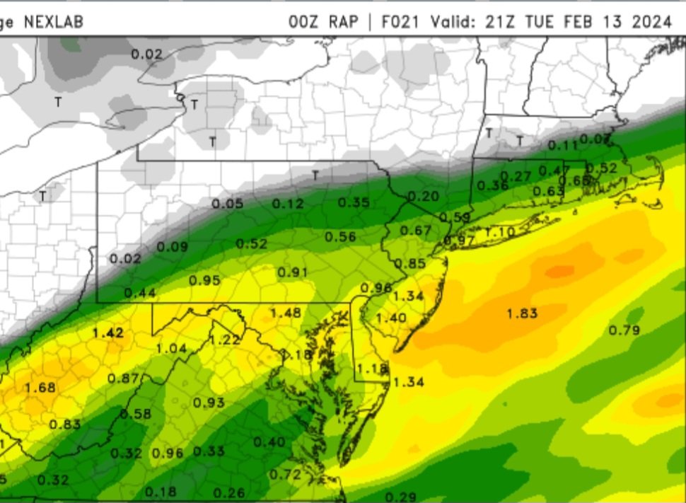
![]() by amugs Mon Feb 12, 2024 9:18 pm
by amugs Mon Feb 12, 2024 9:18 pm
0z RAP
_________________
Mugs
AKA:King: Snow Weenie
Self Proclaimed
WINTER 2014-15 : 55.12" +.02 for 6 coatings (avg. 35")
WINTER 2015-16 Total - 29.8" (Avg 35")
WINTER 2016-17 : 39.5" so far
amugs- Advanced Forecaster - Mod
- Posts : 15093
Reputation : 213
Join date : 2013-01-07
Age : 54
Location : Hillsdale,NJ
Re: FEB 13th Pre V-Day Storm Part II
![]() by CPcantmeasuresnow Mon Feb 12, 2024 9:34 pm
by CPcantmeasuresnow Mon Feb 12, 2024 9:34 pm
Last edited by CPcantmeasuresnow on Mon Feb 12, 2024 9:39 pm; edited 1 time in total
CPcantmeasuresnow- Wx Statistician Guru
- Posts : 7274
Reputation : 230
Join date : 2013-01-07
Age : 103
Location : Eastern Orange County, NY
Re: FEB 13th Pre V-Day Storm Part II
![]() by 2004blackwrx Mon Feb 12, 2024 9:37 pm
by 2004blackwrx Mon Feb 12, 2024 9:37 pm
Last edited by 2004blackwrx on Mon Feb 12, 2024 9:38 pm; edited 1 time in total
2004blackwrx- Pro Enthusiast
- Posts : 576
Reputation : 9
Join date : 2013-01-14
Location : Wappinger NY
Re: FEB 13th Pre V-Day Storm Part II
![]() by 2004blackwrx Mon Feb 12, 2024 9:37 pm
by 2004blackwrx Mon Feb 12, 2024 9:37 pm

2004blackwrx- Pro Enthusiast
- Posts : 576
Reputation : 9
Join date : 2013-01-14
Location : Wappinger NY
Re: FEB 13th Pre V-Day Storm Part II
![]() by 2004blackwrx Mon Feb 12, 2024 9:41 pm
by 2004blackwrx Mon Feb 12, 2024 9:41 pm
CPcantmeasuresnow wrote:Can we call this one of the biggest model fails within 24 hours of a storm in the last ten years at least. The event hadn't happened yet but it's on its way to being that. I at least hope all in NYC and south cash in good.
We have to wait and see. If it was wrong 12 hour ago it may also be wrong now. I feel like models are getting worse not better over last couple of years. We should have a semi accurate forcast 3 days out. This uear we got lots of rain and almost every storm we got way more rain then forecasted.
2004blackwrx- Pro Enthusiast
- Posts : 576
Reputation : 9
Join date : 2013-01-14
Location : Wappinger NY
Re: FEB 13th Pre V-Day Storm Part II
![]() by billg315 Mon Feb 12, 2024 9:44 pm
by billg315 Mon Feb 12, 2024 9:44 pm
CPcantmeasuresnow wrote:Can we call this one of the biggest model fails within 24 hours of a storm in the last ten years at least. The event hadn't happened yet but it's on its way to being that. I at least hope all in NYC and south cash in good.
I would say yes but even worse going back more than 24 hours. If you go back to last Thursday the models had everything from a statewide NJ rainstorm with heavy snow in the mid-HV and NE, to Heavy Snow across the Delmarva to South Jersey with no snow north of NYC; and every solution in between. Worse yet, each model at various points in time presented all of those diverse outcomes, so none were consistent.
The models served two purposes in this case:
1. To confirm there was a storm
2. To confirm that any solution was possible.
I guess there is some value in #1, but very little in #2.
In fact, I guess to pat us on the back, I’d say our guys on here gave more consistent and valuable input/analysis than all the models combined.
billg315- Advanced Forecaster - Mod
- Posts : 4462
Reputation : 185
Join date : 2015-01-24
Age : 50
Location : Flemington, NJ
CPcantmeasuresnow and kalleg like this post
Re: FEB 13th Pre V-Day Storm Part II
![]() by Dunnzoo Mon Feb 12, 2024 9:44 pm
by Dunnzoo Mon Feb 12, 2024 9:44 pm
_________________
Janet
Snowfall winter of 2023-2024 17.5"
Snowfall winter of 2022-2023 6.0"
Snowfall winter of 2021-2022 17.6" 1" sleet 2/25/22
Snowfall winter of 2020-2021 51.1"
Snowfall winter of 2019-2020 8.5"
Snowfall winter of 2018-2019 25.1"
Snowfall winter of 2017-2018 51.9"
Snowfall winter of 2016-2017 45.6"
Snowfall winter of 2015-2016 29.5"
Snowfall winter of 2014-2015 50.55"
Snowfall winter of 2013-2014 66.5"

Dunnzoo- Senior Enthusiast - Mod
- Posts : 4887
Reputation : 68
Join date : 2013-01-11
Age : 62
Location : Westwood, NJ
Re: FEB 13th Pre V-Day Storm Part II
![]() by heehaw453 Mon Feb 12, 2024 9:53 pm
by heehaw453 Mon Feb 12, 2024 9:53 pm
In terms of temperatures the 925's are oozing down and 0C is above route 80 it'll take several hours to slip to TTN area but it will be steadily getting colder for folks.

heehaw453- Advanced Forecaster

- Posts : 3906
Reputation : 86
Join date : 2014-01-20
Location : Bedminster Township, PA Elevation 600' ASL
Re: FEB 13th Pre V-Day Storm Part II
![]() by Frank_Wx Mon Feb 12, 2024 9:59 pm
by Frank_Wx Mon Feb 12, 2024 9:59 pm

_________________
_______________________________________________________________________________________________________
CLICK HERE to view NJ Strong Snowstorm Classifications
Frank_Wx- Godzilla Seeker
- Posts : 21305
Reputation : 328
Join date : 2013-01-05
Age : 31
Location : Jersey City, NJ -
Re: FEB 13th Pre V-Day Storm Part II
![]() by heehaw453 Mon Feb 12, 2024 10:00 pm
by heehaw453 Mon Feb 12, 2024 10:00 pm

heehaw453- Advanced Forecaster
- Posts : 3906
Reputation : 86
Join date : 2014-01-20
Location : Bedminster Township, PA Elevation 600' ASL
jmanley32 likes this post
Re: FEB 13th Pre V-Day Storm Part II
![]() by Frank_Wx Mon Feb 12, 2024 10:03 pm
by Frank_Wx Mon Feb 12, 2024 10:03 pm

_________________
_______________________________________________________________________________________________________
CLICK HERE to view NJ Strong Snowstorm Classifications
Frank_Wx- Godzilla Seeker
- Posts : 21305
Reputation : 328
Join date : 2013-01-05
Age : 31
Location : Jersey City, NJ -
Page 3 of 15 • 1, 2, 3, 4 ... 9 ... 15 ![]()
|
|
|