
 Search
FEB 13th Pre V-Day Storm Part II
Page 1 of 15 • 1, 2, 3 ... 8 ... 15 ![]()

FEB 13th Pre V-Day Storm Part II
![]() by Frank_Wx Mon Feb 12, 2024 2:55 pm
by Frank_Wx Mon Feb 12, 2024 2:55 pm

This is a look at the 500mb set-up valid later this afternoon. Our storm is collecting itself and absorbing gulf moisture near the TN valley. The trough is neutrally tilted. One thing you will notice is the size of the trough is smaller compared to prior east coast snowstorms. In general, the 500mb flow is lacking amplification due to the progressiveness we continue to see out of the Pacific. This will not be a full-scale Miller A. It is purely southern stream driven. More importantly, the PV is situated in SE Canada and pressing south. This feature keeps our storm track to our south versus cutting to our west, while also acting as wall to keep the colder air mass in place. What is not clearly visible in this image is that northern s/w energy which is crossing into the Great Lakes. Unfortunately, and I'll touch on this some more, instead of being the complimentary phasing energy it may end up acting as a "kicker" that shuns our storm more south & east.

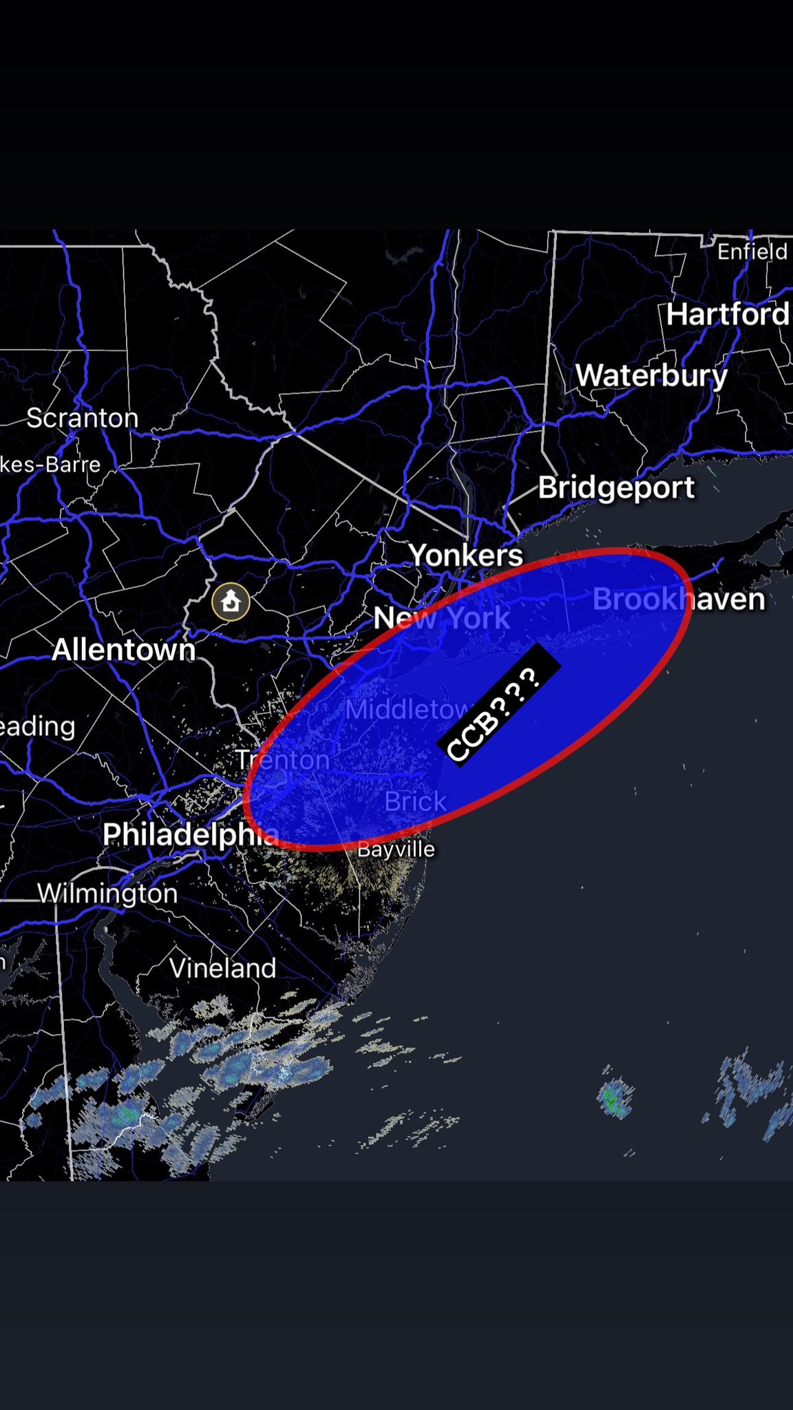
By the time we get to Tuesday morning - valid 10am on the 12z GFS - the trough is already off the coast and the 500mb low closed off south of Long Island. This is a very ideal track of the 500mb low and often times leads to the development of a CCB. This is the "madonne" band that drops 2-3" of snow per hour and can really bury people in a short period of time. One thing to note and I will mention again later is the speed this storm is moving in. It goes from TN to Long Island in record speed. Sadly, we do not have any high latitude blocking to help slow this thing down.
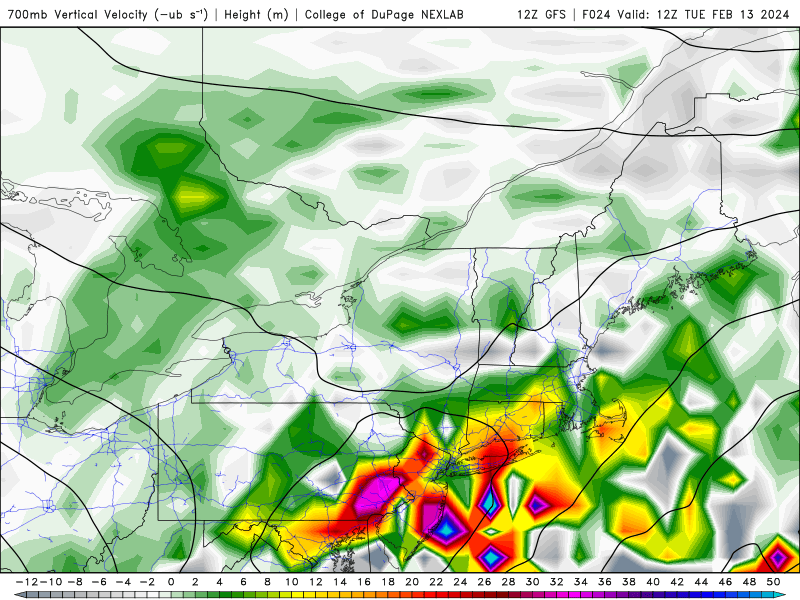
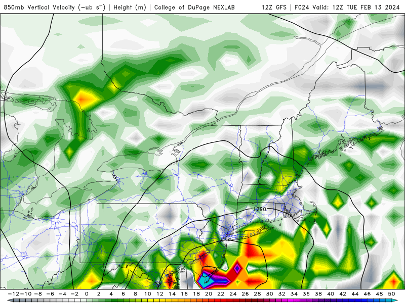
The other thing we look for when it comes to northeast snowstorms is the position of the mid-level low's and whether or not they are vertically stacked. These are the 700mb (top) and 850mb (bottom) lows. You can see the 700mb low is fairly obtuse and covers a large area. The VV's are pretty scattered due to how disorganized everything looks aloft. Nevertheless, there is sufficient forcing entrenched within the low to promote high intensity precip rates. On the other hand, the 850mb low is a little more organized and you can see the low level circulation closed just north of Cape May, NJ. The vertical velocity here is much more concentrated than 700mb and wraps around the LLC nicely.

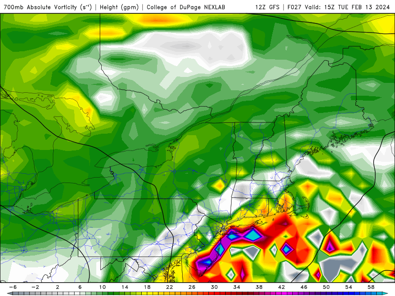
Here's a closer look at the GFS 700mb vorticity output valid for 7am (top) and 10am (bottom). These are the hours models are showing the heaviest precip falling. You can tell, especially from the bottom image, the vorticity is trying to organize itself along the immediate coast, NYC and Long Island. However, in the first picture you can see there are some white/grey colors that appear in parts of NJ (shore points). This actually is subsidence that happens when you are wedged between two areas of VV to your north/south or east/west.
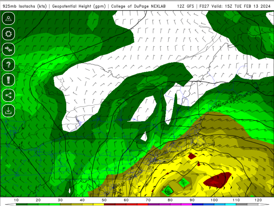
Last thing I want to highlight are the winds at 925mb level. This is valid for 7am, which again is when models (in this case, GFS) have prolific snow falling over the coastal section. One thing you will notice is the wind direction will be out of the east through this evening, then gradually turn northeast by 5-6am tomorrow morning. Eventually the winds turn out of the NW once the low gets into our latitude and begins to pull away east-northeast. It's important to call out the easterly winds that will try to be pesky in keeping the surface temperatures above freezing.

This is why when you compare a regular 10:1 snow map versus a Kuchera 10:1 snowmap, you will see the Kuchera map is actually lower in some parts of the area because its algorithm takes into snow ratios and marginal temps. Above is the snow ratio projection by the EURO valid for 7am Tuesday. Along the coast, ratios range from 5:1 to 7:1. Even N&W of NYC is not seeing exact 10:1 ratios. That said, you can counteract the lower ratios and still achieve impressive snow accumulation through banding (CCB) and frontogenesis (forcing) between 700mb-850mb. But ratios need to be considered in the forecast.
These are the main reasons why my snow map appears lighter than models in terms of accumulations:
1. Duration - very fast. We will change to snow in the overnight hours (closer to sunrise) and precip will be done around lunch time (say 12pm) on Tuesday. Read point #4 to get a better sense of why this is a fast mover.
2. Subsidence - difficult to predict but there are signs that certain areas, especially toward western portions of NJ, will experience it which will cut down on snowfall amounts. I'm not a fan of how scattered all the mid and upper level vorticity is
3. Temperatures - we're getting into the low 40's today and we're dealing with easterly winds through 7am at a minimum. This will keep the surface above freezing. Ratios between 5:1 and 8:1 (6:1 for NYC).
4. Storm track - I can't help but look at the UKMET and EURO and consider their more "southern" track. It would contradict some of the things I mentioned, such as the cold press, northern s/w "kicker" and progressiveness in the overall flow across the country (neutral PNA, collapsing -EPO)

_________________
_______________________________________________________________________________________________________
CLICK HERE to view NJ Strong Snowstorm Classifications

Frank_Wx- Godzilla Seeker

- Posts : 21305
Reputation : 328
Join date : 2013-01-05
Age : 31
Location : Jersey City, NJ -

docstox12, kalleg, billg315, Irish, JT33 and Justice Henry like this post
Re: FEB 13th Pre V-Day Storm Part II
![]() by docstox12 Mon Feb 12, 2024 3:03 pm
by docstox12 Mon Feb 12, 2024 3:03 pm
The way the models have been progressing for my area in the LHV today, I will take that approximately 5 inches happily.Just want to get that for a nice snowpack for the week.Anything above 5 will be a bonus!

docstox12- Wx Statistician Guru

- Posts : 8502
Reputation : 222
Join date : 2013-01-07
Age : 73
Location : Monroe NY
Justice Henry likes this post
Re: FEB 13th Pre V-Day Storm Part II
![]() by Frank_Wx Mon Feb 12, 2024 3:10 pm
by Frank_Wx Mon Feb 12, 2024 3:10 pm
NYC about 7" of snow
South trend continues
_________________
_______________________________________________________________________________________________________
CLICK HERE to view NJ Strong Snowstorm Classifications
Frank_Wx- Godzilla Seeker
- Posts : 21305
Reputation : 328
Join date : 2013-01-05
Age : 31
Location : Jersey City, NJ -
Re: FEB 13th Pre V-Day Storm Part II
![]() by jmanley32 Mon Feb 12, 2024 3:11 pm
by jmanley32 Mon Feb 12, 2024 3:11 pm

jmanley32- Senior Enthusiast

- Posts : 20513
Reputation : 108
Join date : 2013-12-12
Age : 42
Location : Yonkers, NY
Re: FEB 13th Pre V-Day Storm Part II
![]() by jmanley32 Mon Feb 12, 2024 3:13 pm
by jmanley32 Mon Feb 12, 2024 3:13 pm
Ugg we better see these change or stop come 00z, at this point may put NYC at 0 snow (doubt that but the south shift on 18zz was huge. It also lowered the snow totals to a blanket 6-8 max for whole storm.Frank_Wx wrote:18z NAM gives Boston 0" of snow
NYC about 7" of snow
South trend continues
jmanley32- Senior Enthusiast
- Posts : 20513
Reputation : 108
Join date : 2013-12-12
Age : 42
Location : Yonkers, NY
Re: FEB 13th Pre V-Day Storm Part II
![]() by aiannone Mon Feb 12, 2024 3:15 pm
by aiannone Mon Feb 12, 2024 3:15 pm

_________________
-Alex Iannone-

aiannone- Senior Enthusiast - Mod

- Posts : 4813
Reputation : 92
Join date : 2013-01-07
Location : Saint James, LI (Northwest Suffolk Co.)
mmanisca likes this post
Re: FEB 13th Pre V-Day Storm Part II
![]() by CPcantmeasuresnow Mon Feb 12, 2024 3:15 pm
by CPcantmeasuresnow Mon Feb 12, 2024 3:15 pm
jmanley32 wrote:Ugg we better see these change or stop come 00z, at this point may put NYC at 0 snow (doubt that but the south shift on 18zz was huge.Frank_Wx wrote:18z NAM gives Boston 0" of snow
NYC about 7" of snow
South trend continues
Couldn't agree more. 12 hours ago every model had me in double digits, now I'm luck if I get 4. How far south does this go?

CPcantmeasuresnow- Wx Statistician Guru
- Posts : 7274
Reputation : 230
Join date : 2013-01-07
Age : 103
Location : Eastern Orange County, NY
Re: FEB 13th Pre V-Day Storm Part II
![]() by amugs Mon Feb 12, 2024 3:17 pm
by amugs Mon Feb 12, 2024 3:17 pm

_________________
Mugs
AKA:King: Snow Weenie
Self Proclaimed
WINTER 2014-15 : 55.12" +.02 for 6 coatings (avg. 35")
WINTER 2015-16 Total - 29.8" (Avg 35")
WINTER 2016-17 : 39.5" so far

amugs- Advanced Forecaster - Mod
- Posts : 15093
Reputation : 213
Join date : 2013-01-07
Age : 54
Location : Hillsdale,NJ
Angela0621 likes this post
Re: FEB 13th Pre V-Day Storm Part II
![]() by amugs Mon Feb 12, 2024 3:30 pm
by amugs Mon Feb 12, 2024 3:30 pm
Threat over Frank started a thread! We were doing great with Janet's
_________________
Mugs
AKA:King: Snow Weenie
Self Proclaimed
WINTER 2014-15 : 55.12" +.02 for 6 coatings (avg. 35")
WINTER 2015-16 Total - 29.8" (Avg 35")
WINTER 2016-17 : 39.5" so far
amugs- Advanced Forecaster - Mod
- Posts : 15093
Reputation : 213
Join date : 2013-01-07
Age : 54
Location : Hillsdale,NJ
CPcantmeasuresnow, essexcountypete and Irish like this post
Re: FEB 13th Pre V-Day Storm Part II
![]() by heehaw453 Mon Feb 12, 2024 3:35 pm
by heehaw453 Mon Feb 12, 2024 3:35 pm
CPcantmeasuresnow wrote:jmanley32 wrote:Ugg we better see these change or stop come 00z, at this point may put NYC at 0 snow (doubt that but the south shift on 18zz was huge.Frank_Wx wrote:18z NAM gives Boston 0" of snow
NYC about 7" of snow
South trend continues
Couldn't agree more. 12 hours ago every model had me in double digits, now I'm luck if I get 4. How far south does this go?
Latest NAM 3k had sig snow to Cape May. Doubt it, but this storm is as predictable as the stock market.
heehaw453- Advanced Forecaster

- Posts : 3906
Reputation : 86
Join date : 2014-01-20
Location : Bedminster Township, PA Elevation 600' ASL
Re: FEB 13th Pre V-Day Storm Part II
![]() by mmanisca Mon Feb 12, 2024 3:46 pm
by mmanisca Mon Feb 12, 2024 3:46 pm
aiannone wrote:18Z NAM
I’d settle on that here in Deer Park! Guessing even if we get that, the roads would have half the amount being as warm as they are…But we will see how heavy the snow falls to pile it on.

mmanisca- Pro Enthusiast

- Posts : 298
Reputation : 3
Join date : 2013-01-23
Age : 65
Location : Deer Park, Long Island
Re: FEB 13th Pre V-Day Storm Part II
![]() by Goalscore1 Mon Feb 12, 2024 3:55 pm
by Goalscore1 Mon Feb 12, 2024 3:55 pm
Goalscore1- Posts : 11
Reputation : 0
Join date : 2024-01-16
Re: FEB 13th Pre V-Day Storm Part II
![]() by CPcantmeasuresnow Mon Feb 12, 2024 4:01 pm
by CPcantmeasuresnow Mon Feb 12, 2024 4:01 pm
CPcantmeasuresnow- Wx Statistician Guru
- Posts : 7274
Reputation : 230
Join date : 2013-01-07
Age : 103
Location : Eastern Orange County, NY
sroc4, docstox12, amugs, 2004blackwrx, bloc1357, crippo84, essexcountypete and like this post
Re: FEB 13th Pre V-Day Storm Part II
![]() by heehaw453 Mon Feb 12, 2024 4:06 pm
by heehaw453 Mon Feb 12, 2024 4:06 pm

heehaw453- Advanced Forecaster
- Posts : 3906
Reputation : 86
Join date : 2014-01-20
Location : Bedminster Township, PA Elevation 600' ASL
sroc4 likes this post
Re: FEB 13th Pre V-Day Storm Part II
![]() by mmanisca Mon Feb 12, 2024 4:07 pm
by mmanisca Mon Feb 12, 2024 4:07 pm
mmanisca- Pro Enthusiast
- Posts : 298
Reputation : 3
Join date : 2013-01-23
Age : 65
Location : Deer Park, Long Island
sroc4 and weatherwatchermom like this post
Re: FEB 13th Pre V-Day Storm Part II
![]() by frank 638 Mon Feb 12, 2024 4:07 pm
by frank 638 Mon Feb 12, 2024 4:07 pm
frank 638- Senior Enthusiast
- Posts : 2824
Reputation : 37
Join date : 2016-01-01
Age : 40
Location : bronx ny
sroc4, weatherwatchermom, SENJsnowman and silentwreck like this post
Re: FEB 13th Pre V-Day Storm Part II
![]() by docstox12 Mon Feb 12, 2024 4:10 pm
by docstox12 Mon Feb 12, 2024 4:10 pm
CPcantmeasuresnow wrote:This is such a stupid hobby. A grown man obsessing about how much snow he gets LOL.
You got that right my good Freind, here I am at age 73 on this site 20 times looking at nutso maps .Been doing it since 1960 at age 10, there is no hope for you CP.We need a 12 step
"My name is docstox and I am a snowaholic...'
"HI DOCSTOX"!
Lookit we still have a shot at 5 or 6 here, stay the course,LOL.
docstox12- Wx Statistician Guru
- Posts : 8502
Reputation : 222
Join date : 2013-01-07
Age : 73
Location : Monroe NY
CPcantmeasuresnow and billg315 like this post
Re: FEB 13th Pre V-Day Storm Part II
![]() by aiannone Mon Feb 12, 2024 4:26 pm
by aiannone Mon Feb 12, 2024 4:26 pm

_________________
-Alex Iannone-
aiannone- Senior Enthusiast - Mod
- Posts : 4813
Reputation : 92
Join date : 2013-01-07
Location : Saint James, LI (Northwest Suffolk Co.)
sroc4 and mmanisca like this post
Re: FEB 13th Pre V-Day Storm Part II
![]() by GreyBeard Mon Feb 12, 2024 4:28 pm
by GreyBeard Mon Feb 12, 2024 4:28 pm
Quick question,with ratios of 6:1 or 7:1 mean this is going to be a very heavy wet snow? Being in my 70's, not looking forward to having to shovel that type of snow.(no snowblower).
Would it help to pre-treat drive and walkways, or would that just be a waste of time and material if we will see rates of 2 or 3 inches an hour? I've never done that in the past,but I was a lot younger and stronger and more able to handle it back when...
Last edited by GreyBeard on Mon Feb 12, 2024 4:31 pm; edited 1 time in total
GreyBeard- Senior Enthusiast
- Posts : 725
Reputation : 34
Join date : 2014-02-12
Location : eastern nassau county
Re: FEB 13th Pre V-Day Storm Part II
![]() by Goalscore1 Mon Feb 12, 2024 4:29 pm
by Goalscore1 Mon Feb 12, 2024 4:29 pm
Thoughts?
Goalscore1- Posts : 11
Reputation : 0
Join date : 2024-01-16
Re: FEB 13th Pre V-Day Storm Part II
![]() by essexcountypete Mon Feb 12, 2024 4:33 pm
by essexcountypete Mon Feb 12, 2024 4:33 pm
docstox12 wrote:CPcantmeasuresnow wrote:This is such a stupid hobby. A grown man obsessing about how much snow he gets LOL.
You got that right my good Freind, here I am at age 73 on this site 20 times looking at nutso maps .Been doing it since 1960 at age 10, there is no hope for you CP.We need a 12 step
"My name is docstox and I am a snowaholic...'
"HI DOCSTOX"!
Lookit we still have a shot at 5 or 6 here, stay the course,LOL.
We got it bad, and there's nothing you can do about it.
My dad grew up near Lake Michigan and loved snow. He's no longer with us, but my mom, who grew up in Irvington, got the snow bug from him, just like I did. My mom is now 91, and she still calls me when she sees the first flakes flying - "It's SNOWING!!" I hope I'm still giddy about impending snow storms when I'm 91.

essexcountypete- Pro Enthusiast
- Posts : 783
Reputation : 12
Join date : 2013-12-09
Location : Bloomfield, NJ
sroc4, docstox12, weatherwatchermom and billg315 like this post
Re: FEB 13th Pre V-Day Storm Part II
![]() by Irish Mon Feb 12, 2024 4:40 pm
by Irish Mon Feb 12, 2024 4:40 pm
All I've done all day is refresh this forum. What a loser!CPcantmeasuresnow wrote:This is such a stupid hobby. A grown man obsessing about how much snow he gets LOL.

Irish- Pro Enthusiast
- Posts : 788
Reputation : 19
Join date : 2019-01-16
Age : 45
Location : Old Bridge, NJ
sroc4, docstox12, CPcantmeasuresnow, essexcountypete and Sparky Sparticles like this post
Re: FEB 13th Pre V-Day Storm Part II
![]() by sroc4 Mon Feb 12, 2024 4:58 pm
by sroc4 Mon Feb 12, 2024 4:58 pm
CPcantmeasuresnow wrote:This is such a stupid hobby. A grown man obsessing about how much snow he gets LOL.
POST OF THE YEAR!! LOL
_________________
"In weather and in life, there's no winning and losing; there's only winning and learning."
WINTER 2012/2013 TOTALS 43.65"WINTER 2017/2018 TOTALS 62.85" WINTER 2022/2023 TOTALS 4.9"
WINTER 2013/2014 TOTALS 64.85"WINTER 2018/2019 TOTALS 14.25" WINTER 2023/2024 TOTALS 13.1"
WINTER 2014/2015 TOTALS 71.20"WINTER 2019/2020 TOTALS 6.35"
WINTER 2015/2016 TOTALS 35.00"WINTER 2020/2021 TOTALS 37.75"
WINTER 2016/2017 TOTALS 42.25"WINTER 2021/2022 TOTALS 31.65"

sroc4- Admin
- Posts : 8331
Reputation : 301
Join date : 2013-01-07
Location : Wading River, LI
docstox12, CPcantmeasuresnow and Sparky Sparticles like this post
Re: FEB 13th Pre V-Day Storm Part II
![]() by Frank_Wx Mon Feb 12, 2024 5:04 pm
by Frank_Wx Mon Feb 12, 2024 5:04 pm
aiannone wrote:Uptons new map
I disagree with how far north they get and their 12” maximum across Long Island. Thinking the max is probably more like 10”. But if 00z models take a jump north tonight, I can see this map carrying more weight.
GreyBeard wrote:Nice write up,Frank
Quick question,with ratios of 6:1 or 7:1 mean this is going to be a very heavy wet snow? Being in my 70's, not looking forward to having to shovel that type of snow.(no snowblower).
Would it help to pre-treat drive and walkways, or would that just be a waste of time and material if we will see rates of 2 or 3 inches an hour? I've never done that in the past,but I was a lot younger and stronger and more able to handle it back when...
I wish Ray was around to better read the soundings and let us know what the dendrites look like. Yea I do believe this will be pretty heavy. It won’t exactly be pasty but definitely on the wet side. Thing is, your heaviest snow doesn’t arrive until 5am. From 5am-10am you could be looking at 1”/hour rates or higher. Not sure how much pre treatment will help there. Treating before bed seems unnecessary cause it’s going to rain first. Tough one!
Goalscore1 wrote:WSW for southern nassau for 4-8 inches, and zero mention of a mix or rain by the NWS. Even the GFS shows mainly rain and a few hours of snow here, yet the 12z shows 15 inches… Temps near 40 degrees tomorrow. Something isn't adding up.
Thoughts?
What are you using to validate rain or snow? The GFS is mainly SNOW not rain. It will initially start as rain but changeover to snow quickly. From a ground temperature standpoint you’ll be between 35-38 degrees hence why ratios will be 6:1 or so. You can’t look at 10:1 ratio snowfall maps. Either use Kuchera, or better yet, only look at qpf totals and do your own calculation.
Irish wrote:All I've done all day is refresh this forum. What a loser!CPcantmeasuresnow wrote:This is such a stupid hobby. A grown man obsessing about how much snow he gets LOL.
I told my boss I have to write a post for my weather peeps and might not respond for an hour. He understood the assignment
_________________
_______________________________________________________________________________________________________
CLICK HERE to view NJ Strong Snowstorm Classifications
Frank_Wx- Godzilla Seeker
- Posts : 21305
Reputation : 328
Join date : 2013-01-05
Age : 31
Location : Jersey City, NJ -
sroc4, CPcantmeasuresnow, brownie, essexcountypete, GreyBeard, weatherwatchermom, billg315 and Irish like this post
Re: FEB 13th Pre V-Day Storm Part II
![]() by jmanley32 Mon Feb 12, 2024 5:04 pm
by jmanley32 Mon Feb 12, 2024 5:04 pm
Where do I sign 8-12 is way more than this map showed 24 hrs ago. Do you think NWS takes ratios into account or is that 8-12 with the lower ratios?aiannone wrote:Uptons new map
jmanley32- Senior Enthusiast
- Posts : 20513
Reputation : 108
Join date : 2013-12-12
Age : 42
Location : Yonkers, NY
Page 1 of 15 • 1, 2, 3 ... 8 ... 15 ![]()
|
|
|