
 Search
Long Island Blizzard Of 2014 Details / Snow Map #2
Page 1 of 10 • 1, 2, 3, 4, 5, 6, 7, 8, 9, 10 ![]()

Long Island Blizzard Of 2014 Details / Snow Map #2
![]() by Frank_Wx Wed Jan 01, 2014 10:47 pm
by Frank_Wx Wed Jan 01, 2014 10:47 pm

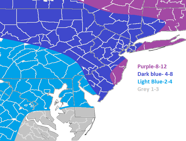
The above is my final snow map for this very tough to forecast storm. Iv'e been harping about this storm for awhile now and have always said the models are struggling big time. Finally, they have come around to the big storm solution but there still exists some uncertainties. Where the low pressure tracks and at what time it deepens, or strengthens, will dictate how this storm plays out.
Orange = blizzard warning
Pink = winter storm warning
Dark blue = winter storm watch
Light blue = coastal flood watch (also under winter storm watches)
Please click on your county to see what the NWS has to say about your area
http://wx.hamweather.com/maps/severe/warnings/all/usnj.html
I am naming this storm after Long Island because they will probably see the worst of it in terms of wind and snowfall, hence the blizzard warnings already issued. This will probably not be a widespread Godzilla-type storm (12+ inches), but isolated areas will see 12 or more inches of snow (refer to my snow map above).
Timing:
Light snow will begin Thursday morning from overrunning precip from the northern stream energy. It could be on and off. The best areas that will see the most overrunning snow are north and west of NYC. This could occur between 9-11am.
Lighter snows will overspread the entire region later in the day, figure between 2-4pm.
Moderate snow will come in the overnight hours. I am expecting moderate snow, which could be heavy at times, to come in between 9-11pm and continue through the night and come to an end between 6-9am Friday morning. Then lighter snow could continue until 11am Friday.
Wind:

Winds will be between 20-25 mph sustained on the island and coastal NJ with gusts potentially reaching 40 mph. Since the snow is going to be fluffy, there will be a lot of blowing snow bringing down visibility. This was the main reason why blizzard warnings were issued.
Temperatures:

^ 1 am Friday

^ 7 am Friday

^ 1 am Friday
You can see how cold it is going to be Thursday night (or early Friday morning) when moderate snow is coming into the area. This is why we are looking at 15:1 ratios, and if the snow were heavier, maybe 20:1 in some places. Snow is going to accumulate very quickly and stick instantly.
Conclusion:
We have to watch this storm carefully. There is still some concern that models are not accurately depicting the strength of the southern stream energy:

All that stream of moisture coming out of Mexico into the southeast U.S. could really energize this storm. Where the surface low tracks is imperative to snow totals. Any closer to the coast, amounts will go higher. Also, if banding sets up over your area, you will see higher snowfall amounts as well. The best banding from the coastal storm should set up somewhere between the Jersey Shore and north and east from there (including northeast NJ). But like I said, if the low comes further west, banding potential could spread west. Basically this has already turned into a nowcasting situation and we will have to monitor the progression of the storm very closely. So stay tuned.
Stay safe!
-Francesco Paparatto
Last edited by Frank_Wx on Thu Jan 02, 2014 2:57 pm; edited 1 time in total
_________________
_______________________________________________________________________________________________________
CLICK HERE to view NJ Strong Snowstorm Classifications

Frank_Wx- Godzilla Seeker

- Posts : 21305
Reputation : 328
Join date : 2013-01-05
Age : 31
Location : Jersey City, NJ -

Re: Long Island Blizzard Of 2014 Details / Snow Map #2
![]() by Quietace Wed Jan 01, 2014 10:49 pm
by Quietace Wed Jan 01, 2014 10:49 pm

Quietace- Meteorologist - Mod

- Posts : 3687
Reputation : 33
Join date : 2013-01-07
Age : 27
Location : Point Pleasant, NJ
Re: Long Island Blizzard Of 2014 Details / Snow Map #2
![]() by Noreaster Wed Jan 01, 2014 10:51 pm
by Noreaster Wed Jan 01, 2014 10:51 pm

Noreaster- Posts : 463
Reputation : 5
Join date : 2013-01-08
Age : 41
Location : Merrick, NY
Re: Long Island Blizzard Of 2014 Details / Snow Map #2
![]() by NjWeatherGuy Wed Jan 01, 2014 10:52 pm
by NjWeatherGuy Wed Jan 01, 2014 10:52 pm

NjWeatherGuy- Advanced Forecaster

- Posts : 4100
Reputation : 28
Join date : 2013-01-06
Location : Belle Mead, NJ
Re: Long Island Blizzard Of 2014 Details / Snow Map #2
![]() by Noreaster Wed Jan 01, 2014 10:53 pm
by Noreaster Wed Jan 01, 2014 10:53 pm
NYC in 6-10"
Nassau, W Suffolk, NJ shore, HV (HV due to ratios) 7-12"
C and E Suffolk 8-14"
Noreaster- Posts : 463
Reputation : 5
Join date : 2013-01-08
Age : 41
Location : Merrick, NY
Re: Long Island Blizzard Of 2014 Details / Snow Map #2
![]() by RJB8525 Wed Jan 01, 2014 10:54 pm
by RJB8525 Wed Jan 01, 2014 10:54 pm

RJB8525- Senior Enthusiast

- Posts : 1994
Reputation : 28
Join date : 2013-02-06
Age : 38
Location : Hackettstown, NJ
Re: Long Island Blizzard Of 2014 Details / Snow Map #2
![]() by Noreaster Wed Jan 01, 2014 10:54 pm
by Noreaster Wed Jan 01, 2014 10:54 pm
Noreaster- Posts : 463
Reputation : 5
Join date : 2013-01-08
Age : 41
Location : Merrick, NY
Re: Long Island Blizzard Of 2014 Details / Snow Map #2
![]() by deadrabbit79 Wed Jan 01, 2014 10:58 pm
by deadrabbit79 Wed Jan 01, 2014 10:58 pm
deadrabbit79- Posts : 176
Reputation : 6
Join date : 2013-01-25
Location : Hartsdale, New York
Re: Long Island Blizzard Of 2014 Details / Snow Map #2
![]() by algae888 Wed Jan 01, 2014 10:59 pm
by algae888 Wed Jan 01, 2014 10:59 pm
STRONGER 500MB WINDS IN BOTH CANADA AND OVER THE SERN CONUS THAN
THE MODELS ARE FORECASTING. THE 00Z NAM SOLUTION WAS TO DIG THE
500MB TROF FURTHER, BUT SHEAR THE SOUTHERN STREAM SHORT WAVES MORE
AND TAKES THE INITIAL LOW FARTHER OFFSHORE. THE TROF STRUCTURE IS
LESS NEGATIVE TILT AS A RESULT AND ITS QPF A COUPLE OF TENTHS FROM
THE DAY RUN.
IN THE CONUS, THE ECMWF 12HR FCST WAS VERIFYING THE BEST WITH THE
500MB TROF, IN WESTERN CANADA, THE GFS WAS VERIFYING THE BEST AND
THE ERRORS WERE STILL AROUND 10M WITH THE RIDGE (TOO LOW). AT
850MB ANY ERRORS WERE AROUND 1C TOO WARM.
can the stronger 500mb winds have any affect on how models are playing out this storm. ie stronger low closer to coast or weaker storm further offshore?

algae888- Advanced Forecaster
- Posts : 5311
Reputation : 46
Join date : 2013-02-05
Age : 61
Location : mt. vernon, new york
Re: Long Island Blizzard Of 2014 Details / Snow Map #2
![]() by NjWeatherGuy Wed Jan 01, 2014 10:59 pm
by NjWeatherGuy Wed Jan 01, 2014 10:59 pm
Noreaster wrote:Make a call Tom!!!! lol
I pretty much agree with your forecast except I don't think there will be amounts over a foot, IDK why it's just a feeling of mine.
NjWeatherGuy- Advanced Forecaster
- Posts : 4100
Reputation : 28
Join date : 2013-01-06
Location : Belle Mead, NJ
Re: Long Island Blizzard Of 2014 Details / Snow Map #2
![]() by CPcantmeasuresnow Wed Jan 01, 2014 11:00 pm
by CPcantmeasuresnow Wed Jan 01, 2014 11:00 pm

CPcantmeasuresnow- Wx Statistician Guru

- Posts : 7274
Reputation : 230
Join date : 2013-01-07
Age : 103
Location : Eastern Orange County, NY
Re: Long Island Blizzard Of 2014 Details / Snow Map #2
![]() by jmanley32 Wed Jan 01, 2014 11:05 pm
by jmanley32 Wed Jan 01, 2014 11:05 pm

jmanley32- Senior Enthusiast
- Posts : 20516
Reputation : 108
Join date : 2013-12-12
Age : 42
Location : Yonkers, NY
Re: Long Island Blizzard Of 2014 Details / Snow Map #2
![]() by jmanley32 Wed Jan 01, 2014 11:06 pm
by jmanley32 Wed Jan 01, 2014 11:06 pm
jmanley32- Senior Enthusiast
- Posts : 20516
Reputation : 108
Join date : 2013-12-12
Age : 42
Location : Yonkers, NY
Re: Long Island Blizzard Of 2014 Details / Snow Map #2
![]() by Frank_Wx Wed Jan 01, 2014 11:07 pm
by Frank_Wx Wed Jan 01, 2014 11:07 pm
_________________
_______________________________________________________________________________________________________
CLICK HERE to view NJ Strong Snowstorm Classifications
Frank_Wx- Godzilla Seeker
- Posts : 21305
Reputation : 328
Join date : 2013-01-05
Age : 31
Location : Jersey City, NJ -
Re: Long Island Blizzard Of 2014 Details / Snow Map #2
![]() by Quietace Wed Jan 01, 2014 11:08 pm
by Quietace Wed Jan 01, 2014 11:08 pm
Quietace- Meteorologist - Mod
- Posts : 3687
Reputation : 33
Join date : 2013-01-07
Age : 27
Location : Point Pleasant, NJ
Re: Long Island Blizzard Of 2014 Details / Snow Map #2
![]() by Frank_Wx Wed Jan 01, 2014 11:11 pm
by Frank_Wx Wed Jan 01, 2014 11:11 pm
Quietace wrote:Ill throw a prediction out. Here is my map.
This is where most maps are around the web, and I definitely agree with it. I'm just more bullish.
_________________
_______________________________________________________________________________________________________
CLICK HERE to view NJ Strong Snowstorm Classifications
Frank_Wx- Godzilla Seeker
- Posts : 21305
Reputation : 328
Join date : 2013-01-05
Age : 31
Location : Jersey City, NJ -
Re: Long Island Blizzard Of 2014 Details / Snow Map #2
![]() by Frank_Wx Wed Jan 01, 2014 11:11 pm
by Frank_Wx Wed Jan 01, 2014 11:11 pm
_________________
_______________________________________________________________________________________________________
CLICK HERE to view NJ Strong Snowstorm Classifications
Frank_Wx- Godzilla Seeker
- Posts : 21305
Reputation : 328
Join date : 2013-01-05
Age : 31
Location : Jersey City, NJ -
Re: Long Island Blizzard Of 2014 Details / Snow Map #2
![]() by jmanley32 Wed Jan 01, 2014 11:12 pm
by jmanley32 Wed Jan 01, 2014 11:12 pm
jmanley32- Senior Enthusiast
- Posts : 20516
Reputation : 108
Join date : 2013-12-12
Age : 42
Location : Yonkers, NY
Re: Long Island Blizzard Of 2014 Details / Snow Map #2
![]() by Quietace Wed Jan 01, 2014 11:12 pm
by Quietace Wed Jan 01, 2014 11:12 pm
Yes, the closer to the coast the better you will do i believe.jmanley32 wrote:Is that with the high ratios ace? 4 inches would sux.
Quietace- Meteorologist - Mod
- Posts : 3687
Reputation : 33
Join date : 2013-01-07
Age : 27
Location : Point Pleasant, NJ
Re: Long Island Blizzard Of 2014 Details / Snow Map #2
![]() by jmanley32 Wed Jan 01, 2014 11:13 pm
by jmanley32 Wed Jan 01, 2014 11:13 pm
jmanley32- Senior Enthusiast
- Posts : 20516
Reputation : 108
Join date : 2013-12-12
Age : 42
Location : Yonkers, NY
Re: Long Island Blizzard Of 2014 Details / Snow Map #2
![]() by Noreaster Wed Jan 01, 2014 11:14 pm
by Noreaster Wed Jan 01, 2014 11:14 pm
Noreaster- Posts : 463
Reputation : 5
Join date : 2013-01-08
Age : 41
Location : Merrick, NY
Re: Long Island Blizzard Of 2014 Details / Snow Map #2
![]() by Quietace Wed Jan 01, 2014 11:14 pm
by Quietace Wed Jan 01, 2014 11:14 pm
I like 6 for the city.jmanley32 wrote:Well I am like 10 miles north of the city so thats pretty close.
Quietace- Meteorologist - Mod
- Posts : 3687
Reputation : 33
Join date : 2013-01-07
Age : 27
Location : Point Pleasant, NJ
Re: Long Island Blizzard Of 2014 Details / Snow Map #2
![]() by Noreaster Wed Jan 01, 2014 11:17 pm
by Noreaster Wed Jan 01, 2014 11:17 pm
I have u in my 7-12" category but I think you are closer to the 7 than the 12.jmanley32 wrote:Well I am like 10 miles north of the city so thats pretty close.
Noreaster- Posts : 463
Reputation : 5
Join date : 2013-01-08
Age : 41
Location : Merrick, NY
Re: Long Island Blizzard Of 2014 Details / Snow Map #2
![]() by Noreaster Wed Jan 01, 2014 11:18 pm
by Noreaster Wed Jan 01, 2014 11:18 pm
6-8 seems perfect for nyc ..I have nyc in the 6-10 in category.Quietace wrote:I like 6 for the city.jmanley32 wrote:Well I am like 10 miles north of the city so thats pretty close.
Noreaster- Posts : 463
Reputation : 5
Join date : 2013-01-08
Age : 41
Location : Merrick, NY
Re: Long Island Blizzard Of 2014 Details / Snow Map #2
![]() by Noreaster Wed Jan 01, 2014 11:20 pm
by Noreaster Wed Jan 01, 2014 11:20 pm
Noreaster- Posts : 463
Reputation : 5
Join date : 2013-01-08
Age : 41
Location : Merrick, NY
Page 1 of 10 • 1, 2, 3, 4, 5, 6, 7, 8, 9, 10 ![]()
|
|
|