
 Search
Observations/ Final Discussion Thread 1/2 - 1/3, 2014 Snowstorm
Page 7 of 26 •  1 ... 6, 7, 8 ... 16 ... 26
 ![]()
Re: Observations/ Final Discussion Thread 1/2 - 1/3, 2014 Snowstorm
![]() by Noreaster Thu Jan 02, 2014 5:55 pm
by Noreaster Thu Jan 02, 2014 5:55 pm
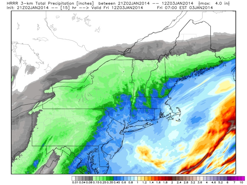
.HRRR looks like it will end precip my 9/10am or so if you extrapolate it.amugs wrote:
Noreaster- Posts : 463
Join date : 2013-01-08
Re: Observations/ Final Discussion Thread 1/2 - 1/3, 2014 Snowstorm
![]() by Debz Thu Jan 02, 2014 5:57 pm
by Debz Thu Jan 02, 2014 5:57 pm
Debz- Posts : 14
Join date : 2013-12-30
Re: Observations/ Final Discussion Thread 1/2 - 1/3, 2014 Snowstorm
![]() by crippo84 Thu Jan 02, 2014 6:02 pm
by crippo84 Thu Jan 02, 2014 6:02 pm

crippo84- Posts : 383
Reputation : 20
Join date : 2013-11-07
Age : 40
Location : East Village, NYC
Re: Observations/ Final Discussion Thread 1/2 - 1/3, 2014 Snowstorm
![]() by docstox12 Thu Jan 02, 2014 6:04 pm
by docstox12 Thu Jan 02, 2014 6:04 pm
Noreaster wrote:Haha no bit sometimes when it is too cold aloft ratios ramp back down to 10:1 although I don't see that happening this time. It was more just food for thought.docstox12 wrote:Does that fit under the "It's too cold to snow" category?
This is really interesting that ratios do help up to a point, then ramp down.Never knew that.Thanks Noreaster, I learned something here and for an old dog like me,that's something!

docstox12- Wx Statistician Guru

- Posts : 8507
Reputation : 222
Join date : 2013-01-07
Age : 73
Location : Monroe NY
Re: Observations/ Final Discussion Thread 1/2 - 1/3, 2014 Snowstorm
![]() by Noreaster Thu Jan 02, 2014 6:12 pm
by Noreaster Thu Jan 02, 2014 6:12 pm

Noreaster- Posts : 463
Reputation : 5
Join date : 2013-01-08
Age : 41
Location : Merrick, NY
Re: Observations/ Final Discussion Thread 1/2 - 1/3, 2014 Snowstorm
![]() by docstox12 Thu Jan 02, 2014 6:14 pm
by docstox12 Thu Jan 02, 2014 6:14 pm
docstox12- Wx Statistician Guru
- Posts : 8507
Reputation : 222
Join date : 2013-01-07
Age : 73
Location : Monroe NY
Re: Observations/ Final Discussion Thread 1/2 - 1/3, 2014 Snowstorm
![]() by Dunnzoo Thu Jan 02, 2014 6:16 pm
by Dunnzoo Thu Jan 02, 2014 6:16 pm
_________________
Janet
Snowfall winter of 2023-2024 17.5"
Snowfall winter of 2022-2023 6.0"
Snowfall winter of 2021-2022 17.6" 1" sleet 2/25/22
Snowfall winter of 2020-2021 51.1"
Snowfall winter of 2019-2020 8.5"
Snowfall winter of 2018-2019 25.1"
Snowfall winter of 2017-2018 51.9"
Snowfall winter of 2016-2017 45.6"
Snowfall winter of 2015-2016 29.5"
Snowfall winter of 2014-2015 50.55"
Snowfall winter of 2013-2014 66.5"

Dunnzoo- Senior Enthusiast - Mod

- Posts : 4892
Reputation : 68
Join date : 2013-01-11
Age : 62
Location : Westwood, NJ
Re: Observations/ Final Discussion Thread 1/2 - 1/3, 2014 Snowstorm
![]() by Noreaster Thu Jan 02, 2014 6:16 pm
by Noreaster Thu Jan 02, 2014 6:16 pm
Noreaster- Posts : 463
Reputation : 5
Join date : 2013-01-08
Age : 41
Location : Merrick, NY
Re: Observations/ Final Discussion Thread 1/2 - 1/3, 2014 Snowstorm
![]() by jbnyy224 Thu Jan 02, 2014 6:17 pm
by jbnyy224 Thu Jan 02, 2014 6:17 pm
jbnyy224- Posts : 83
Reputation : 0
Join date : 2013-01-11
Age : 38
Location : Brooklyn, NY
Re: Observations/ Final Discussion Thread 1/2 - 1/3, 2014 Snowstorm
![]() by bloc1357 Thu Jan 02, 2014 6:18 pm
by bloc1357 Thu Jan 02, 2014 6:18 pm
Noreaster wrote:I'm hearing from a met of another site that soundings over LI indicate banding and thundersnow potential.
Cantore from TWC will be pissed if LI gets thundersnow and where he is in Boston doesn't.....LOL
bloc1357- Pro Enthusiast

- Posts : 344
Reputation : 10
Join date : 2013-03-05
Age : 47
Location : West Babylon, NY - 11704
Re: Observations/ Final Discussion Thread 1/2 - 1/3, 2014 Snowstorm
![]() by Quietace Thu Jan 02, 2014 6:19 pm
by Quietace Thu Jan 02, 2014 6:19 pm

Quietace- Meteorologist - Mod

- Posts : 3687
Reputation : 33
Join date : 2013-01-07
Age : 27
Location : Point Pleasant, NJ
Re: Observations/ Final Discussion Thread 1/2 - 1/3, 2014 Snowstorm
![]() by Quietace Thu Jan 02, 2014 6:21 pm
by Quietace Thu Jan 02, 2014 6:21 pm
Quietace- Meteorologist - Mod
- Posts : 3687
Reputation : 33
Join date : 2013-01-07
Age : 27
Location : Point Pleasant, NJ
Re: Observations/ Final Discussion Thread 1/2 - 1/3, 2014 Snowstorm
![]() by SoulSingMG Thu Jan 02, 2014 6:21 pm
by SoulSingMG Thu Jan 02, 2014 6:21 pm

SoulSingMG- Senior Enthusiast

- Posts : 2853
Reputation : 74
Join date : 2013-12-11
Location : Long Island City, NY
Re: Observations/ Final Discussion Thread 1/2 - 1/3, 2014 Snowstorm
![]() by Quietace Thu Jan 02, 2014 6:23 pm
by Quietace Thu Jan 02, 2014 6:23 pm
"Image #1 is the snowfall map off of the 18z GFS of expected totals snow, not accounting for anything that already fell prior to 1pm today. On this image we placed adjusted amounts as we cross-referenced the upper air soundings to account for higher snow ratios. These amounts match our final call map (image #2 - which does not need to be adjusted for higher ratios - they are factored in), and there are no changes to it.... STANDS AS CALLED. The heaviest concentration of snow will fall in our 6-10"+ areas, and some areas from SE PA to New Jersey could approach 1 foot of snow. Image #3: Arctic shortwave (see the purple circle over Mississippi on the map) has progressed to the base of the trough already. This will cause the trough to tilt negative in the next 3-4 hours. Given that the trough axis is still well west of us, this will cause the eastward march of the precip shield to halt and expand, and the coastal SHOULD be held closer to the coast. This should result in heavy snow for several hours into the overnight for just about all of the area. This will remain a dry powdery snow that will accumulate quickly, and winds will increase overnight to 15-25mph sustained with higher gusts over 30mph, so there will be blowing and drifting of snow. If you are worried about dry slots on radar, don't be... this will go through the night and will be heaviest for eastern PA and New Jersey between about 7pm and 3am. We will be watching the radar for frontogentic banding to occur, and best chance for that to occur us from the Lehigh Valley and points east and southeast."
Quietace- Meteorologist - Mod
- Posts : 3687
Reputation : 33
Join date : 2013-01-07
Age : 27
Location : Point Pleasant, NJ
Re: Observations/ Final Discussion Thread 1/2 - 1/3, 2014 Snowstorm
![]() by Dwsi91 Thu Jan 02, 2014 6:25 pm
by Dwsi91 Thu Jan 02, 2014 6:25 pm
Dwsi91- Posts : 28
Reputation : 1
Join date : 2013-11-24
Re: Observations/ Final Discussion Thread 1/2 - 1/3, 2014 Snowstorm
![]() by Quietace Thu Jan 02, 2014 6:26 pm
by Quietace Thu Jan 02, 2014 6:26 pm
Quietace- Meteorologist - Mod
- Posts : 3687
Reputation : 33
Join date : 2013-01-07
Age : 27
Location : Point Pleasant, NJ
Re: Observations/ Final Discussion Thread 1/2 - 1/3, 2014 Snowstorm
![]() by Dwsi91 Thu Jan 02, 2014 6:27 pm
by Dwsi91 Thu Jan 02, 2014 6:27 pm
Dwsi91- Posts : 28
Reputation : 1
Join date : 2013-11-24
Re: Observations/ Final Discussion Thread 1/2 - 1/3, 2014 Snowstorm
![]() by skinsfan1177 Thu Jan 02, 2014 6:28 pm
by skinsfan1177 Thu Jan 02, 2014 6:28 pm

skinsfan1177- Senior Enthusiast
- Posts : 4485
Reputation : 35
Join date : 2013-01-07
Age : 46
Location : Point Pleasant Boro
Re: Observations/ Final Discussion Thread 1/2 - 1/3, 2014 Snowstorm
![]() by Quietace Thu Jan 02, 2014 6:29 pm
by Quietace Thu Jan 02, 2014 6:29 pm
Finally did 1014mb in NCskinsfan1177 wrote:Ace I think 6 to 12 is right but im leaning on the higher end of that. Is the low trying to form
http://www.spc.noaa.gov/exper/mesoanalysis/s19/pmsl/pmsl.gif?1388705345435
Quietace- Meteorologist - Mod
- Posts : 3687
Reputation : 33
Join date : 2013-01-07
Age : 27
Location : Point Pleasant, NJ
Re: Observations/ Final Discussion Thread 1/2 - 1/3, 2014 Snowstorm
![]() by skinsfan1177 Thu Jan 02, 2014 6:30 pm
by skinsfan1177 Thu Jan 02, 2014 6:30 pm
skinsfan1177- Senior Enthusiast
- Posts : 4485
Reputation : 35
Join date : 2013-01-07
Age : 46
Location : Point Pleasant Boro
Re: Observations/ Final Discussion Thread 1/2 - 1/3, 2014 Snowstorm
![]() by Quietace Thu Jan 02, 2014 6:31 pm
by Quietace Thu Jan 02, 2014 6:31 pm
Quietace- Meteorologist - Mod
- Posts : 3687
Reputation : 33
Join date : 2013-01-07
Age : 27
Location : Point Pleasant, NJ
Re: Observations/ Final Discussion Thread 1/2 - 1/3, 2014 Snowstorm
![]() by Quietace Thu Jan 02, 2014 6:31 pm
by Quietace Thu Jan 02, 2014 6:31 pm
Mistype, yes 1004mbskinsfan1177 wrote:that's good right 1004 or 1014
Quietace- Meteorologist - Mod
- Posts : 3687
Reputation : 33
Join date : 2013-01-07
Age : 27
Location : Point Pleasant, NJ
Re: Observations/ Final Discussion Thread 1/2 - 1/3, 2014 Snowstorm
![]() by skinsfan1177 Thu Jan 02, 2014 6:33 pm
by skinsfan1177 Thu Jan 02, 2014 6:33 pm
skinsfan1177- Senior Enthusiast
- Posts : 4485
Reputation : 35
Join date : 2013-01-07
Age : 46
Location : Point Pleasant Boro
Re: Observations/ Final Discussion Thread 1/2 - 1/3, 2014 Snowstorm
![]() by Quietace Thu Jan 02, 2014 6:34 pm
by Quietace Thu Jan 02, 2014 6:34 pm
Quietace- Meteorologist - Mod
- Posts : 3687
Reputation : 33
Join date : 2013-01-07
Age : 27
Location : Point Pleasant, NJ
Re: Observations/ Final Discussion Thread 1/2 - 1/3, 2014 Snowstorm
![]() by skinsfan1177 Thu Jan 02, 2014 6:35 pm
by skinsfan1177 Thu Jan 02, 2014 6:35 pm
skinsfan1177- Senior Enthusiast
- Posts : 4485
Reputation : 35
Join date : 2013-01-07
Age : 46
Location : Point Pleasant Boro
Re: Observations/ Final Discussion Thread 1/2 - 1/3, 2014 Snowstorm
![]() by Quietace Thu Jan 02, 2014 6:37 pm
by Quietace Thu Jan 02, 2014 6:37 pm
Quietace- Meteorologist - Mod
- Posts : 3687
Reputation : 33
Join date : 2013-01-07
Age : 27
Location : Point Pleasant, NJ
Re: Observations/ Final Discussion Thread 1/2 - 1/3, 2014 Snowstorm
![]() by Quietace Thu Jan 02, 2014 6:41 pm
by Quietace Thu Jan 02, 2014 6:41 pm
Quietace- Meteorologist - Mod
- Posts : 3687
Reputation : 33
Join date : 2013-01-07
Age : 27
Location : Point Pleasant, NJ
Sponsored content
Page 7 of 26 • 1 ... 6, 7, 8 ... 16 ... 26 ![]()
|
|
|