
 Search
Observations/ Final Discussion Thread 1/2 - 1/3, 2014 Snowstorm
Page 9 of 26 •  1 ... 6 ... 8, 9, 10 ... 17 ... 26
 ![]()
Re: Observations/ Final Discussion Thread 1/2 - 1/3, 2014 Snowstorm
![]() by skinsfan1177 Thu Jan 02, 2014 7:04 pm
by skinsfan1177 Thu Jan 02, 2014 7:04 pm
skinsfan1177- Senior Enthusiast

- Posts : 4485
Join date : 2013-01-07
Re: Observations/ Final Discussion Thread 1/2 - 1/3, 2014 Snowstorm
![]() by RJB8525 Thu Jan 02, 2014 7:04 pm
by RJB8525 Thu Jan 02, 2014 7:04 pm
RJB8525- Senior Enthusiast
- Posts : 1994
Join date : 2013-02-06
Re: Observations/ Final Discussion Thread 1/2 - 1/3, 2014 Snowstorm
![]() by SNOW MAN Thu Jan 02, 2014 7:05 pm
by SNOW MAN Thu Jan 02, 2014 7:05 pm

SNOW MAN- Senior Enthusiast
- Posts : 1361
Reputation : 25
Join date : 2013-01-13
Age : 64
Location : Marshalls Creek Pa.
Re: Observations/ Final Discussion Thread 1/2 - 1/3, 2014 Snowstorm
![]() by cooladi Thu Jan 02, 2014 7:05 pm
by cooladi Thu Jan 02, 2014 7:05 pm
cooladi- Pro Enthusiast

- Posts : 185
Reputation : 2
Join date : 2013-01-08
Location : East Rockaway, NY 11518
Re: Observations/ Final Discussion Thread 1/2 - 1/3, 2014 Snowstorm
![]() by Quietace Thu Jan 02, 2014 7:07 pm
by Quietace Thu Jan 02, 2014 7:07 pm
Workskinsfan1177 wrote:Where is Frank?

Quietace- Meteorologist - Mod

- Posts : 3687
Reputation : 33
Join date : 2013-01-07
Age : 27
Location : Point Pleasant, NJ
Re: Observations/ Final Discussion Thread 1/2 - 1/3, 2014 Snowstorm
![]() by bloc1357 Thu Jan 02, 2014 7:08 pm
by bloc1357 Thu Jan 02, 2014 7:08 pm
skinsfan1177 wrote:Where is Frank?
Working until 9...I think he said
bloc1357- Pro Enthusiast
- Posts : 344
Reputation : 10
Join date : 2013-03-05
Age : 47
Location : West Babylon, NY - 11704
Re: Observations/ Final Discussion Thread 1/2 - 1/3, 2014 Snowstorm
![]() by SNOW MAN Thu Jan 02, 2014 7:10 pm
by SNOW MAN Thu Jan 02, 2014 7:10 pm
SNOW MAN- Senior Enthusiast
- Posts : 1361
Reputation : 25
Join date : 2013-01-13
Age : 64
Location : Marshalls Creek Pa.
Re: Observations/ Final Discussion Thread 1/2 - 1/3, 2014 Snowstorm
![]() by Quietace Thu Jan 02, 2014 7:12 pm
by Quietace Thu Jan 02, 2014 7:12 pm
6-8SNOW MAN wrote:Ace I'm staying at Moms in Whiting NJ for the holidays, it's close to Toms River. What's your call for snow totals in this area?
Quietace- Meteorologist - Mod
- Posts : 3687
Reputation : 33
Join date : 2013-01-07
Age : 27
Location : Point Pleasant, NJ
Re: Observations/ Final Discussion Thread 1/2 - 1/3, 2014 Snowstorm
![]() by SNOW MAN Thu Jan 02, 2014 7:17 pm
by SNOW MAN Thu Jan 02, 2014 7:17 pm
SNOW MAN- Senior Enthusiast
- Posts : 1361
Reputation : 25
Join date : 2013-01-13
Age : 64
Location : Marshalls Creek Pa.
Re: Observations/ Final Discussion Thread 1/2 - 1/3, 2014 Snowstorm
![]() by jmanley32 Thu Jan 02, 2014 7:19 pm
by jmanley32 Thu Jan 02, 2014 7:19 pm

jmanley32- Senior Enthusiast
- Posts : 20517
Reputation : 108
Join date : 2013-12-12
Age : 42
Location : Yonkers, NY
Re: Observations/ Final Discussion Thread 1/2 - 1/3, 2014 Snowstorm
![]() by docstox12 Thu Jan 02, 2014 7:21 pm
by docstox12 Thu Jan 02, 2014 7:21 pm

docstox12- Wx Statistician Guru

- Posts : 8507
Reputation : 222
Join date : 2013-01-07
Age : 73
Location : Monroe NY
Re: Observations/ Final Discussion Thread 1/2 - 1/3, 2014 Snowstorm
![]() by Fededle22 Thu Jan 02, 2014 7:22 pm
by Fededle22 Thu Jan 02, 2014 7:22 pm
Fededle22- Posts : 169
Reputation : 2
Join date : 2013-03-08
Location : West Orange, NJ
Re: Observations/ Final Discussion Thread 1/2 - 1/3, 2014 Snowstorm
![]() by Grselig Thu Jan 02, 2014 7:23 pm
by Grselig Thu Jan 02, 2014 7:23 pm

Grselig- Senior Enthusiast
- Posts : 1408
Reputation : 140
Join date : 2013-03-04
Age : 54
Location : Wayne NJ
Re: Observations/ Final Discussion Thread 1/2 - 1/3, 2014 Snowstorm
![]() by Quietace Thu Jan 02, 2014 7:23 pm
by Quietace Thu Jan 02, 2014 7:23 pm
http://www.spc.noaa.gov/exper/mesoanalysis/s19/500mb/500mb.gif?1388708552645
Quietace- Meteorologist - Mod
- Posts : 3687
Reputation : 33
Join date : 2013-01-07
Age : 27
Location : Point Pleasant, NJ
Re: Observations/ Final Discussion Thread 1/2 - 1/3, 2014 Snowstorm
![]() by amugs Thu Jan 02, 2014 7:25 pm
by amugs Thu Jan 02, 2014 7:25 pm
Quietace wrote:500mb looks good. Moving from neutral over the last hour...
http://www.spc.noaa.gov/exper/mesoanalysis/s19/500mb/500mb.gif?1388708552645
Tilt Negative you beast and then explode!!
_________________
Mugs
AKA:King: Snow Weenie
Self Proclaimed
WINTER 2014-15 : 55.12" +.02 for 6 coatings (avg. 35")
WINTER 2015-16 Total - 29.8" (Avg 35")
WINTER 2016-17 : 39.5" so far

amugs- Advanced Forecaster - Mod

- Posts : 15093
Reputation : 213
Join date : 2013-01-07
Age : 54
Location : Hillsdale,NJ
Re: Observations/ Final Discussion Thread 1/2 - 1/3, 2014 Snowstorm
![]() by Quietace Thu Jan 02, 2014 7:26 pm
by Quietace Thu Jan 02, 2014 7:26 pm
The dry slot seen on the radar image below will not advance much. The reasoning is because our primary low is jumping over to the coast (NC). This is temporarily allowing the precip shield to collapse to the east. As this low intensifies and moves northward it will allow the radar returns to advance more north and west. This goes back to the "negative tilted trough" explanation in last post. When the trough goes negative it leads to rapidly rising air downstream. In this case, it would be over our region and the developing low. This creates a stronger low that will not be able to escape to the east and greater lifting for heavier snow.
https://scontent-a-lga.xx.fbcdn.net/hphotos-ash3/1477586_444713808962898_3881831_n.png
Quietace- Meteorologist - Mod
- Posts : 3687
Reputation : 33
Join date : 2013-01-07
Age : 27
Location : Point Pleasant, NJ
Re: Observations/ Final Discussion Thread 1/2 - 1/3, 2014 Snowstorm
![]() by Quietace Thu Jan 02, 2014 7:27 pm
by Quietace Thu Jan 02, 2014 7:27 pm
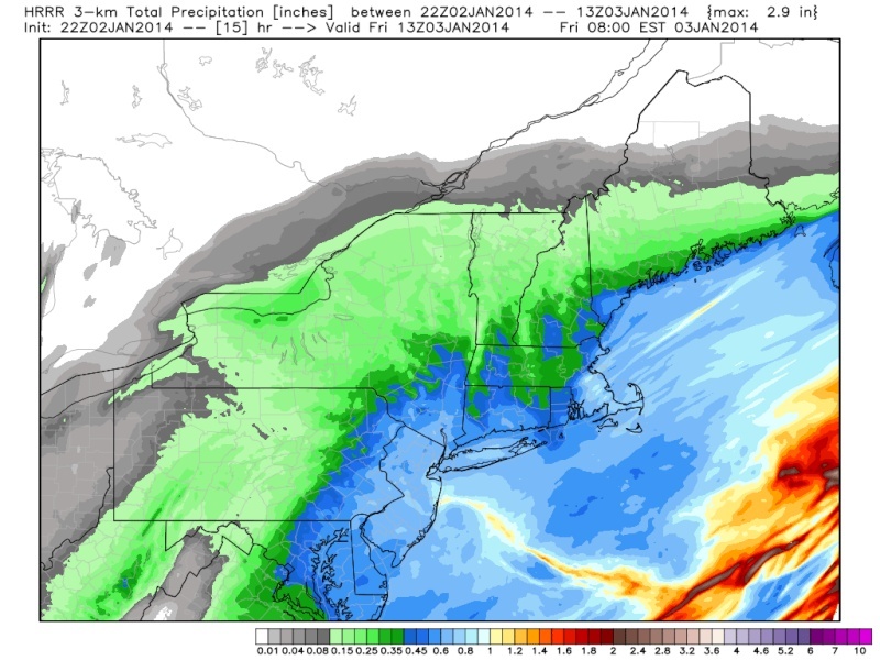
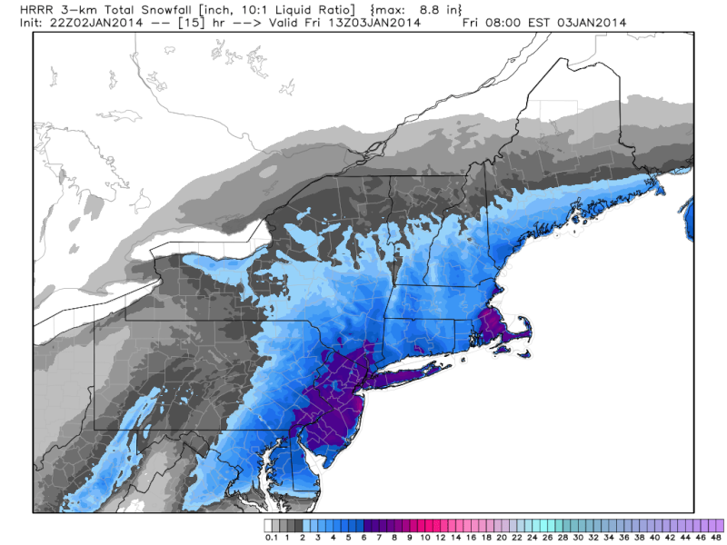
The HRRR is starting to catch on to this. Has been increasing QPF each run. Almost 1 inch for JS and LI. Widspread .75amugs wrote:Quietace wrote:500mb looks good. Moving from neutral over the last hour...
http://www.spc.noaa.gov/exper/mesoanalysis/s19/500mb/500mb.gif?1388708552645
Tilt Negative you beast and then explode!!
Quietace- Meteorologist - Mod
- Posts : 3687
Reputation : 33
Join date : 2013-01-07
Age : 27
Location : Point Pleasant, NJ
Re: Observations/ Final Discussion Thread 1/2 - 1/3, 2014 Snowstorm
![]() by aiannone Thu Jan 02, 2014 7:27 pm
by aiannone Thu Jan 02, 2014 7:27 pm
_________________
-Alex Iannone-

aiannone- Senior Enthusiast - Mod
- Posts : 4814
Reputation : 92
Join date : 2013-01-07
Location : Saint James, LI (Northwest Suffolk Co.)
Re: Observations/ Final Discussion Thread 1/2 - 1/3, 2014 Snowstorm
![]() by docstox12 Thu Jan 02, 2014 7:34 pm
by docstox12 Thu Jan 02, 2014 7:34 pm
Quietace wrote:The HRRR is starting to catch on to this. Has been increasing QPF each run. Almost 1 inch for JS and LI. Widspread .75amugs wrote:Quietace wrote:500mb looks good. Moving from neutral over the last hour...
http://www.spc.noaa.gov/exper/mesoanalysis/s19/500mb/500mb.gif?1388708552645
Tilt Negative you beast and then explode!!
There's your widespread one foot at these temps.We'll see overnight how it pans out, but this is good news.
docstox12- Wx Statistician Guru
- Posts : 8507
Reputation : 222
Join date : 2013-01-07
Age : 73
Location : Monroe NY
Re: Observations/ Final Discussion Thread 1/2 - 1/3, 2014 Snowstorm
![]() by Quietace Thu Jan 02, 2014 7:34 pm
by Quietace Thu Jan 02, 2014 7:34 pm
Quietace- Meteorologist - Mod
- Posts : 3687
Reputation : 33
Join date : 2013-01-07
Age : 27
Location : Point Pleasant, NJ
Re: Observations/ Final Discussion Thread 1/2 - 1/3, 2014 Snowstorm
![]() by devsman Thu Jan 02, 2014 7:36 pm
by devsman Thu Jan 02, 2014 7:36 pm

devsman- Pro Enthusiast
- Posts : 424
Reputation : 4
Join date : 2014-01-01
Age : 48
Location : merrick, ny (south shore of Long Island)
Re: Observations/ Final Discussion Thread 1/2 - 1/3, 2014 Snowstorm
![]() by skinsfan1177 Thu Jan 02, 2014 7:37 pm
by skinsfan1177 Thu Jan 02, 2014 7:37 pm

skinsfan1177- Senior Enthusiast
- Posts : 4485
Reputation : 35
Join date : 2013-01-07
Age : 46
Location : Point Pleasant Boro
Re: Observations/ Final Discussion Thread 1/2 - 1/3, 2014 Snowstorm
![]() by Noreaster Thu Jan 02, 2014 7:41 pm
by Noreaster Thu Jan 02, 2014 7:41 pm
"A few folks have asked about snow ratios and what affects snow ratios. I'm not a meteorologist, but I am an expert in nucleation/crystallization phase changes (in the chemical/pharmaceutical industry, but the concepts apply almost exactly to snow).
So, for those who are curious why our snow ratios will be so high (15-20:1, which means 0.5" of liquid gives 7.5-10" of snow, instead of the usual 5" of snow in a typical 10:1 ratio), conditions are expected to be very favorable for large, dry, fluffy snow crystals in the primary snow growth region (around 700 mb of pressure, several thousand feet up in the atmosphere). Hope what follows helps.
Specifically, as relatively warm, moist air saturated with water vapor is lifted into the 700 mb region, which will be very cold, relatively speaking vs. "typical" snowstorms, i.e., temps will be about -10 to -22C at that level, this will lead to that water vapor becoming highly superaturated, meaning the relative humidity of that parcel of air at that temperature actually well exceeds 100%, which denotes being supersaturated, i.e., beyond 100% saturation; thermodynamically, this situation cannot exist for long, as that supersaturated vapor wants to either condense into liquid or directly condense into frozen particles, depending on the temp (and pressure).
This supersaturation leads to very fast snow crystal nucleation (the creation of snow crystals at those cold temps aloft), followed by good dendritic snow growth (via vapor phase deposition - the water vapor that remains supersaturated in the parcel essentially changes phases from vapor to ice, as it crystallizes and grows directly on the "starter crystals" that just nucleated) on those crystals, leading to dendrites and plates. These dendtrites and plates "layer" better on the ground, such that there is more air present in the snow on the ground, resulting in a lower bulk density (low mass per unit volume) of that snow or a greater snow depth to liquid equivalent ratio. Think of a pile of dry leaves vs. a pile of wet, aged leaves, in which the dry leaves contain ar less leaves and far more air per unit volume vs. wet leaves.
To get powdery, fluffy, low bulk density snow, one needs both conditions, though: cold temps in the snow growth region, plus good vertical lift to drive the supersaturation - it's the vertical lift which carries warm, relatively moist air from the surface (or near the surface) up into the primary snow growth region around 700 mb (to be sure, supersaturation and nucleation/crystallization occur at more heights than 700 mb - it's just that the 700 mb region is the "standard" referred to), which leads to the supersaturation and at the right temps, the good plates/dendrites form and grow. See the link for the pics of the crystals one typically gets at various temps in the snow growth region.
Why -10 to -22C in the snow growth layer leads to plates and dendrites vs. rods or cubes is unclear to me. Perhaps that's something I should look into..."
http://stream2.cma.gov.cn/pub/comet/MountainMeteorology/SnowpackandItsAssessment/comet/afwa/snowpack/media/graphics/habits.jpg

Noreaster- Posts : 463
Reputation : 5
Join date : 2013-01-08
Age : 41
Location : Merrick, NY
Re: Observations/ Final Discussion Thread 1/2 - 1/3, 2014 Snowstorm
![]() by amugs Thu Jan 02, 2014 7:42 pm
by amugs Thu Jan 02, 2014 7:42 pm
skins we r there up here as we speak at18* woohooooskinsfan1177 wrote:Ratios will get to 15:1 at some point.
Bring on the foot plus Hercules - greedy I know lol.
_________________
Mugs
AKA:King: Snow Weenie
Self Proclaimed
WINTER 2014-15 : 55.12" +.02 for 6 coatings (avg. 35")
WINTER 2015-16 Total - 29.8" (Avg 35")
WINTER 2016-17 : 39.5" so far
amugs- Advanced Forecaster - Mod
- Posts : 15093
Reputation : 213
Join date : 2013-01-07
Age : 54
Location : Hillsdale,NJ
Re: Observations/ Final Discussion Thread 1/2 - 1/3, 2014 Snowstorm
![]() by amugs Thu Jan 02, 2014 7:45 pm
by amugs Thu Jan 02, 2014 7:45 pm
Noreaster wrote:From a poster at americanwx regarding ratios..its good info and stuff some of us know but he put it pretty simply which is helpful.
"A few folks have asked about snow ratios and what affects snow ratios. I'm not a meteorologist, but I am an expert in nucleation/crystallization phase changes (in the chemical/pharmaceutical industry, but the concepts apply almost exactly to snow).
So, for those who are curious why our snow ratios will be so high (15-20:1, which means 0.5" of liquid gives 7.5-10" of snow, instead of the usual 5" of snow in a typical 10:1 ratio), conditions are expected to be very favorable for large, dry, fluffy snow crystals in the primary snow growth region (around 700 mb of pressure, several thousand feet up in the atmosphere). Hope what follows helps.
That is great info . Nor you post or follow that board?
Specifically, as relatively warm, moist air saturated with water vapor is lifted into the 700 mb region, which will be very cold, relatively speaking vs. "typical" snowstorms, i.e., temps will be about -10 to -22C at that level, this will lead to that water vapor becoming highly superaturated, meaning the relative humidity of that parcel of air at that temperature actually well exceeds 100%, which denotes being supersaturated, i.e., beyond 100% saturation; thermodynamically, this situation cannot exist for long, as that supersaturated vapor wants to either condense into liquid or directly condense into frozen particles, depending on the temp (and pressure).
This supersaturation leads to very fast snow crystal nucleation (the creation of snow crystals at those cold temps aloft), followed by good dendritic snow growth (via vapor phase deposition - the water vapor that remains supersaturated in the parcel essentially changes phases from vapor to ice, as it crystallizes and grows directly on the "starter crystals" that just nucleated) on those crystals, leading to dendrites and plates. These dendtrites and plates "layer" better on the ground, such that there is more air present in the snow on the ground, resulting in a lower bulk density (low mass per unit volume) of that snow or a greater snow depth to liquid equivalent ratio. Think of a pile of dry leaves vs. a pile of wet, aged leaves, in which the dry leaves contain ar less leaves and far more air per unit volume vs. wet leaves.
To get powdery, fluffy, low bulk density snow, one needs both conditions, though: cold temps in the snow growth region, plus good vertical lift to drive the supersaturation - it's the vertical lift which carries warm, relatively moist air from the surface (or near the surface) up into the primary snow growth region around 700 mb (to be sure, supersaturation and nucleation/crystallization occur at more heights than 700 mb - it's just that the 700 mb region is the "standard" referred to), which leads to the supersaturation and at the right temps, the good plates/dendrites form and grow. See the link for the pics of the crystals one typically gets at various temps in the snow growth region.
Why -10 to -22C in the snow growth layer leads to plates and dendrites vs. rods or cubes is unclear to me. Perhaps that's something I should look into..."
http://stream2.cma.gov.cn/pub/comet/MountainMeteorology/SnowpackandItsAssessment/comet/afwa/snowpack/media/graphics/habits.jpg
_________________
Mugs
AKA:King: Snow Weenie
Self Proclaimed
WINTER 2014-15 : 55.12" +.02 for 6 coatings (avg. 35")
WINTER 2015-16 Total - 29.8" (Avg 35")
WINTER 2016-17 : 39.5" so far
amugs- Advanced Forecaster - Mod
- Posts : 15093
Reputation : 213
Join date : 2013-01-07
Age : 54
Location : Hillsdale,NJ
Re: Observations/ Final Discussion Thread 1/2 - 1/3, 2014 Snowstorm
![]() by deadrabbit79 Thu Jan 02, 2014 7:45 pm
by deadrabbit79 Thu Jan 02, 2014 7:45 pm
deadrabbit79- Posts : 176
Reputation : 6
Join date : 2013-01-25
Location : Hartsdale, New York
Re: Observations/ Final Discussion Thread 1/2 - 1/3, 2014 Snowstorm
![]() by snowday111 Thu Jan 02, 2014 7:47 pm
by snowday111 Thu Jan 02, 2014 7:47 pm
Just got my call from my district. My kids district will be closed as well. Some districts are waiting until 8:00 to send out a call.amugs wrote:18* and light to moderate snow over here in Hillsdale, NENJ - waiting for the NO SCHOOL phone call in the next 1/2 hr or so...
Going to make some TollHouse Cookies, Hot Chocolate with some homemade Bailey's, sit by my fire, watch the snow fall and then cap it off with a glass of port wine - priceless.
snowday111- Posts : 92
Reputation : 1
Join date : 2013-01-07
Location : Monroe Twp. NJ (Middlesex County)
Sponsored content
Page 9 of 26 • 1 ... 6 ... 8, 9, 10 ... 17 ... 26 ![]()
|
|
|