
 Search
Official Long Range Thread 3.0
Page 17 of 32 •  1 ... 10 ... 16, 17, 18 ... 24 ... 32
 ![]()
Re: Official Long Range Thread 3.0
![]() by devsman Thu Oct 02, 2014 8:43 pm
by devsman Thu Oct 02, 2014 8:43 pm
devsman- Pro Enthusiast

- Posts : 424
Join date : 2014-01-01
Re: Official Long Range Thread 3.0
![]() by jmanley32 Thu Oct 02, 2014 8:45 pm
by jmanley32 Thu Oct 02, 2014 8:45 pm
jmanley32- Senior Enthusiast

- Posts : 20517
Join date : 2013-12-12
Re: Official Long Range Thread 3.0
![]() by amugs Fri Oct 03, 2014 8:37 am
by amugs Fri Oct 03, 2014 8:37 am

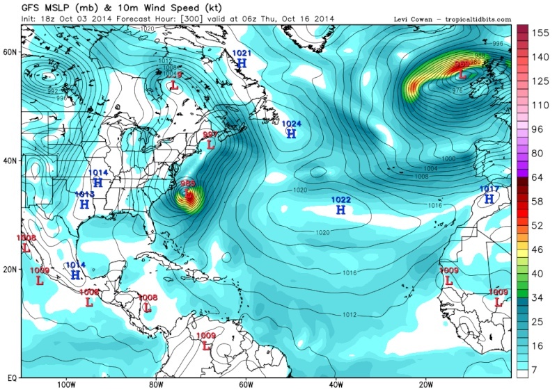
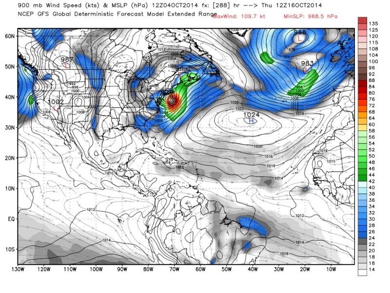
Here is fantasy by the GFS.
_________________
Mugs
AKA:King: Snow Weenie
Self Proclaimed
WINTER 2014-15 : 55.12" +.02 for 6 coatings (avg. 35")
WINTER 2015-16 Total - 29.8" (Avg 35")
WINTER 2016-17 : 39.5" so far

amugs- Advanced Forecaster - Mod

- Posts : 15093
Reputation : 213
Join date : 2013-01-07
Age : 54
Location : Hillsdale,NJ
Re: Official Long Range Thread 3.0
![]() by jmanley32 Fri Oct 03, 2014 11:16 am
by jmanley32 Fri Oct 03, 2014 11:16 am

jmanley32- Senior Enthusiast
- Posts : 20517
Reputation : 108
Join date : 2013-12-12
Age : 42
Location : Yonkers, NY
Re: Official Long Range Thread 3.0
![]() by jmanley32 Fri Oct 03, 2014 11:20 am
by jmanley32 Fri Oct 03, 2014 11:20 am
jmanley32- Senior Enthusiast
- Posts : 20517
Reputation : 108
Join date : 2013-12-12
Age : 42
Location : Yonkers, NY
Re: Official Long Range Thread 3.0
![]() by jmanley32 Fri Oct 03, 2014 1:56 pm
by jmanley32 Fri Oct 03, 2014 1:56 pm

jmanley32- Senior Enthusiast
- Posts : 20517
Reputation : 108
Join date : 2013-12-12
Age : 42
Location : Yonkers, NY
Re: Official Long Range Thread 3.0
![]() by jmanley32 Fri Oct 03, 2014 2:57 pm
by jmanley32 Fri Oct 03, 2014 2:57 pm
jmanley32- Senior Enthusiast
- Posts : 20517
Reputation : 108
Join date : 2013-12-12
Age : 42
Location : Yonkers, NY
Re: Official Long Range Thread 3.0
![]() by devsman Fri Oct 03, 2014 5:07 pm
by devsman Fri Oct 03, 2014 5:07 pm

devsman- Pro Enthusiast
- Posts : 424
Reputation : 4
Join date : 2014-01-01
Age : 48
Location : merrick, ny (south shore of Long Island)
Re: Official Long Range Thread 3.0
![]() by jmanley32 Fri Oct 03, 2014 7:05 pm
by jmanley32 Fri Oct 03, 2014 7:05 pm
jmanley32- Senior Enthusiast
- Posts : 20517
Reputation : 108
Join date : 2013-12-12
Age : 42
Location : Yonkers, NY
Re: Official Long Range Thread 3.0
![]() by jmanley32 Fri Oct 03, 2014 7:11 pm
by jmanley32 Fri Oct 03, 2014 7:11 pm

70mph sustained, wow. It was west now east who knows where it will go, or if it will even form. Something in my gut tells me this is not looking good but thats going on the relentlessly unreliable GFS this summer and my gut so nothing concrete.
jmanley32- Senior Enthusiast
- Posts : 20517
Reputation : 108
Join date : 2013-12-12
Age : 42
Location : Yonkers, NY
Re: Official Long Range Thread 3.0
![]() by skinsfan1177 Fri Oct 03, 2014 7:29 pm
by skinsfan1177 Fri Oct 03, 2014 7:29 pm

skinsfan1177- Senior Enthusiast
- Posts : 4485
Reputation : 35
Join date : 2013-01-07
Age : 46
Location : Point Pleasant Boro
Re: Official Long Range Thread 3.0
![]() by jmanley32 Fri Oct 03, 2014 8:39 pm
by jmanley32 Fri Oct 03, 2014 8:39 pm
jmanley32- Senior Enthusiast
- Posts : 20517
Reputation : 108
Join date : 2013-12-12
Age : 42
Location : Yonkers, NY
Re: Official Long Range Thread 3.0
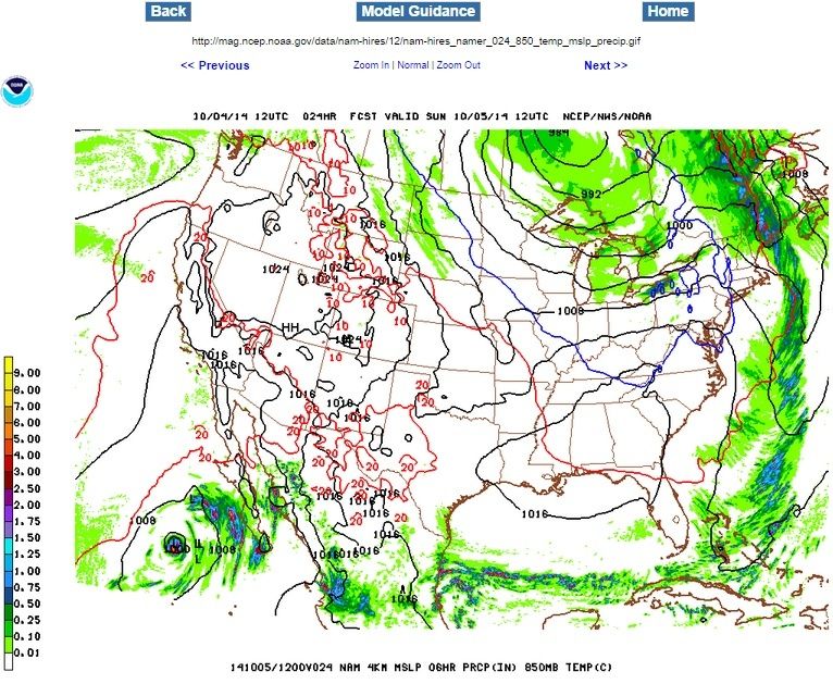
![]() by Math23x7 Sat Oct 04, 2014 3:26 pm
by Math23x7 Sat Oct 04, 2014 3:26 pm
Math23x7- Wx Statistician Guru

- Posts : 2379
Reputation : 68
Join date : 2013-01-08
Re: Official Long Range Thread 3.0
![]() by algae888 Sat Oct 04, 2014 3:36 pm
by algae888 Sat Oct 04, 2014 3:36 pm

algae888- Advanced Forecaster

- Posts : 5311
Reputation : 46
Join date : 2013-02-05
Age : 61
Location : mt. vernon, new york
Re: Official Long Range Thread 3.0
![]() by amugs Sat Oct 04, 2014 4:00 pm
by amugs Sat Oct 04, 2014 4:00 pm
If you recall I posted a map from Mr Euro earlier saying a big trough was going to slide over the east coast around the 15th and looked to be an active period - possible coastals - would not surprise and thanks for bringing it up again - Oct can churn up some good storms.
Winter analogs flying around wx boards are for a 1978-79, 1995-96 type winter - we shall see due to various factors of course (the one's In Frank We Trust handed out at our gathering - QBO scale, solar activity and planetary signals/alignments)
It is going to be tough because even though the AO is to tank -2+ and the NAO goes negative but further North in the Atlantic is seems to be a pretty fast flow across the CONUS as per the 6Z GFS yesterday. Hey it could all change sure but we'll see
_________________
Mugs
AKA:King: Snow Weenie
Self Proclaimed
WINTER 2014-15 : 55.12" +.02 for 6 coatings (avg. 35")
WINTER 2015-16 Total - 29.8" (Avg 35")
WINTER 2016-17 : 39.5" so far
amugs- Advanced Forecaster - Mod
- Posts : 15093
Reputation : 213
Join date : 2013-01-07
Age : 54
Location : Hillsdale,NJ
Re: Official Long Range Thread 3.0
![]() by algae888 Sat Oct 04, 2014 4:29 pm
by algae888 Sat Oct 04, 2014 4:29 pm
amugs wrote:Al,
If you recall I posted a map from Mr Euro earlier saying a big trough was going to slide over the east coast around the 15th and looked to be an active period - possible coastals - would not surprise and thanks for bringing it up again - Oct can churn up some good storms.
Winter analogs flying around wx boards are for a 1978-79, 1995-96 type winter - we shall see due to various factors of course (the one's In Frank We Trust handed out at our gathering - QBO scale, solar activity and planetary signals/alignments)
It is going to be tough because even though the AO is to tank -2+ and the NAO goes negative but further North in the Atlantic is seems to be a pretty fast flow across the CONUS as per the 6Z GFS yesterday. Hey it could all change sure but we'll see
yes mugs I remember and the gfs had it too. hopefully everything is starting to align itself so we can have a great active winter.
algae888- Advanced Forecaster
- Posts : 5311
Reputation : 46
Join date : 2013-02-05
Age : 61
Location : mt. vernon, new york
Re: Official Long Range Thread 3.0
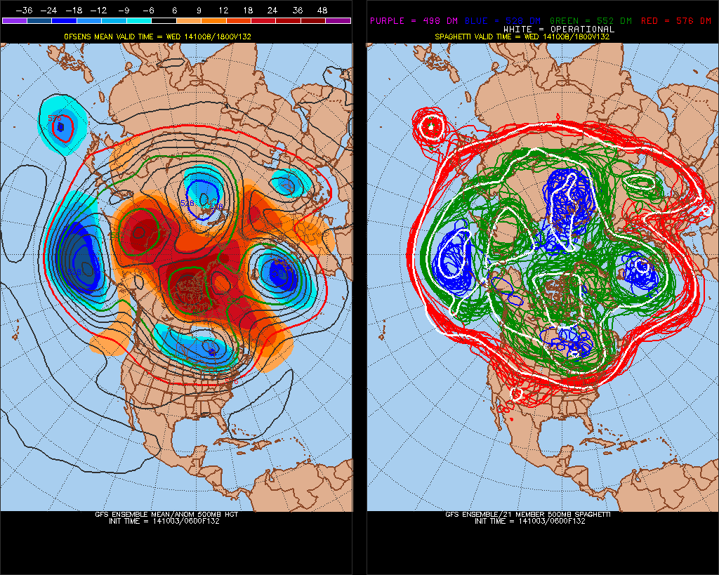
![]() by algae888 Sat Oct 04, 2014 4:36 pm
by algae888 Sat Oct 04, 2014 4:36 pm
http://mag.ncep.noaa.gov/Imageanis.php
this is the 500 mb map of storm jman been talking about. look at the kink in the trough (short wave) along the east coast. it moves right up the coast.
algae888- Advanced Forecaster
- Posts : 5311
Reputation : 46
Join date : 2013-02-05
Age : 61
Location : mt. vernon, new york
Re: Official Long Range Thread 3.0
![]() by algae888 Sat Oct 04, 2014 4:39 pm
by algae888 Sat Oct 04, 2014 4:39 pm
algae888- Advanced Forecaster
- Posts : 5311
Reputation : 46
Join date : 2013-02-05
Age : 61
Location : mt. vernon, new york
Re: Official Long Range Thread 3.0
![]() by jmanley32 Sat Oct 04, 2014 5:14 pm
by jmanley32 Sat Oct 04, 2014 5:14 pm
Last edited by jmanley32 on Sat Oct 04, 2014 5:21 pm; edited 1 time in total
jmanley32- Senior Enthusiast
- Posts : 20517
Reputation : 108
Join date : 2013-12-12
Age : 42
Location : Yonkers, NY
Re: Official Long Range Thread 3.0
![]() by jmanley32 Sat Oct 04, 2014 5:18 pm
by jmanley32 Sat Oct 04, 2014 5:18 pm
jmanley32- Senior Enthusiast
- Posts : 20517
Reputation : 108
Join date : 2013-12-12
Age : 42
Location : Yonkers, NY
Re: Official Long Range Thread 3.0
![]() by NjWeatherGuy Sat Oct 04, 2014 5:41 pm
by NjWeatherGuy Sat Oct 04, 2014 5:41 pm

NjWeatherGuy- Advanced Forecaster
- Posts : 4100
Reputation : 28
Join date : 2013-01-06
Location : Belle Mead, NJ
Re: Official Long Range Thread 3.0
![]() by jmanley32 Sat Oct 04, 2014 5:57 pm
by jmanley32 Sat Oct 04, 2014 5:57 pm
jmanley32- Senior Enthusiast
- Posts : 20517
Reputation : 108
Join date : 2013-12-12
Age : 42
Location : Yonkers, NY
Re: Official Long Range Thread 3.0
![]() by amugs Sat Oct 04, 2014 6:26 pm
by amugs Sat Oct 04, 2014 6:26 pm

_________________
Mugs
AKA:King: Snow Weenie
Self Proclaimed
WINTER 2014-15 : 55.12" +.02 for 6 coatings (avg. 35")
WINTER 2015-16 Total - 29.8" (Avg 35")
WINTER 2016-17 : 39.5" so far
amugs- Advanced Forecaster - Mod
- Posts : 15093
Reputation : 213
Join date : 2013-01-07
Age : 54
Location : Hillsdale,NJ
Re: Official Long Range Thread 3.0
![]() by amugs Sat Oct 04, 2014 6:27 pm
by amugs Sat Oct 04, 2014 6:27 pm
_________________
Mugs
AKA:King: Snow Weenie
Self Proclaimed
WINTER 2014-15 : 55.12" +.02 for 6 coatings (avg. 35")
WINTER 2015-16 Total - 29.8" (Avg 35")
WINTER 2016-17 : 39.5" so far
amugs- Advanced Forecaster - Mod
- Posts : 15093
Reputation : 213
Join date : 2013-01-07
Age : 54
Location : Hillsdale,NJ
Re: Official Long Range Thread 3.0
![]() by jmanley32 Sat Oct 04, 2014 6:31 pm
by jmanley32 Sat Oct 04, 2014 6:31 pm
jmanley32- Senior Enthusiast
- Posts : 20517
Reputation : 108
Join date : 2013-12-12
Age : 42
Location : Yonkers, NY
Re: Official Long Range Thread 3.0
![]() by skinsfan1177 Sat Oct 04, 2014 7:56 pm
by skinsfan1177 Sat Oct 04, 2014 7:56 pm
skinsfan1177- Senior Enthusiast
- Posts : 4485
Reputation : 35
Join date : 2013-01-07
Age : 46
Location : Point Pleasant Boro
Re: Official Long Range Thread 3.0
![]() by algae888 Sat Oct 04, 2014 8:49 pm
by algae888 Sat Oct 04, 2014 8:49 pm
skinsfan1177 wrote:I really hope fpr no nor easter we are still recovering here at the shore.
I doubt very much that we will see any thing close to sandy. however wx will be very active the next two weeks. here is disco from nws....
A FULL LATITUDE LARGE TROUGH AND CLOSED LOW WILL REMAIN ACROSS THE
EASTERN HALF OF THE COUNTRY AT THE START OF THE EXTENDED PERIOD. A
SHORTWAVE TROUGH WILL BE ROTATING THROUGH THE TROUGH MONDAY NIGHT
INTO TUESDAY WITH AN ASSOCIATED FRONTAL SYSTEM APPROACHING. A WARM
FRONT MOVES THROUGH TUESDAY FOLLOWED BY A COLD FRONT WEDNESDAY. THE
UPPER TROUGH WEAKENS WEDNESDAY INTO THURSDAY AS A SOUTHERN STREAM
RIDGE BUILDS INTO THE SOUTHERN STATES AND THE NORTHERN STREAM
BECOMES MORE ZONAL. ANOTHER SHORTWAVE WILL BE ROTATING THROUGH THE
UPPER TROUGH WEDNESDAY NIGHT INTO THURSDAY SENDING ANOTHER FRONTAL
SYSTEM TOWARD THE AREA. WILL ONLY BE A BRIEF BREAK IN THE DRY
WEATHER AND WILL INTRODUCE POPS BACK INTO THE AREA LATE THURSDAY
INTO THURSDAY NIGHT. WAVES OF LOW PRESSURE WILL THEN AFFECT THE
NORTHEAST INTO NEXT WEEKEND.
algae888- Advanced Forecaster
- Posts : 5311
Reputation : 46
Join date : 2013-02-05
Age : 61
Location : mt. vernon, new york
Page 17 of 32 • 1 ... 10 ... 16, 17, 18 ... 24 ... 32 ![]()
|
|
|