
 Search
December 29th-30th Potential Overrunning event
Page 5 of 6 •  1, 2, 3, 4, 5, 6
 ![]()
Re: December 29th-30th Potential Overrunning event
![]() by Guest Fri Dec 26, 2014 6:49 am
by Guest Fri Dec 26, 2014 6:49 am
Guest- Guest
Re: December 29th-30th Potential Overrunning event
![]() by sroc4 Fri Dec 26, 2014 9:24 am
by sroc4 Fri Dec 26, 2014 9:24 am
I cant get the loop to work in the post so here is the link to the loop.
http://mp1.met.psu.edu/~fxg1/SAT_NHEM/animwjap.html

sroc4- Admin

- Posts : 8331
Join date : 2013-01-07
Re: December 29th-30th Potential Overrunning event
![]() by Frank_Wx Fri Dec 26, 2014 10:39 am
by Frank_Wx Fri Dec 26, 2014 10:39 am
_________________
_______________________________________________________________________________________________________
CLICK HERE to view NJ Strong Snowstorm Classifications

Frank_Wx- Godzilla Seeker
- Posts : 21305
Reputation : 328
Join date : 2013-01-05
Age : 31
Location : Jersey City, NJ -

Re: December 29th-30th Potential Overrunning event
![]() by sroc4 Fri Dec 26, 2014 10:44 am
by sroc4 Fri Dec 26, 2014 10:44 am
Frank_Wx wrote:The threat is not dead, but the differences from model run to model run gives me agita
Thats just the truth Frank. The Gods honest truth. Do I believe that surprise snow WILL actually pan out...not really. But with the chaos theory in full effect with these dang models, and with the energy from the STJ in poor sampling area over the subtropics S and W of Mexico, and with current satellite observations showing a healthy batch of STJ convection firing up and beginning to lift towards Mexico and the GOM I am going to continue to post about it until I feel 100% confident it is no longer a threat. (deep sigh)
_________________
"In weather and in life, there's no winning and losing; there's only winning and learning."
WINTER 2012/2013 TOTALS 43.65"WINTER 2017/2018 TOTALS 62.85" WINTER 2022/2023 TOTALS 4.9"
WINTER 2013/2014 TOTALS 64.85"WINTER 2018/2019 TOTALS 14.25" WINTER 2023/2024 TOTALS 13.1"
WINTER 2014/2015 TOTALS 71.20"WINTER 2019/2020 TOTALS 6.35"
WINTER 2015/2016 TOTALS 35.00"WINTER 2020/2021 TOTALS 37.75"
WINTER 2016/2017 TOTALS 42.25"WINTER 2021/2022 TOTALS 31.65"

sroc4- Admin
- Posts : 8331
Reputation : 301
Join date : 2013-01-07
Location : Wading River, LI
Re: December 29th-30th Potential Overrunning event
![]() by Frank_Wx Fri Dec 26, 2014 11:07 am
by Frank_Wx Fri Dec 26, 2014 11:07 am
_________________
_______________________________________________________________________________________________________
CLICK HERE to view NJ Strong Snowstorm Classifications
Frank_Wx- Godzilla Seeker
- Posts : 21305
Reputation : 328
Join date : 2013-01-05
Age : 31
Location : Jersey City, NJ -
Re: December 29th-30th Potential Overrunning event
![]() by Frank_Wx Fri Dec 26, 2014 11:38 am
by Frank_Wx Fri Dec 26, 2014 11:38 am


_________________
_______________________________________________________________________________________________________
CLICK HERE to view NJ Strong Snowstorm Classifications
Frank_Wx- Godzilla Seeker
- Posts : 21305
Reputation : 328
Join date : 2013-01-05
Age : 31
Location : Jersey City, NJ -
Re: December 29th-30th Potential Overrunning event
![]() by Frank_Wx Fri Dec 26, 2014 11:40 am
by Frank_Wx Fri Dec 26, 2014 11:40 am
_________________
_______________________________________________________________________________________________________
CLICK HERE to view NJ Strong Snowstorm Classifications
Frank_Wx- Godzilla Seeker
- Posts : 21305
Reputation : 328
Join date : 2013-01-05
Age : 31
Location : Jersey City, NJ -
Re: December 29th-30th Potential Overrunning event
![]() by Math23x7 Fri Dec 26, 2014 4:55 pm
by Math23x7 Fri Dec 26, 2014 4:55 pm
Math23x7- Wx Statistician Guru

- Posts : 2379
Reputation : 68
Join date : 2013-01-08
Re: December 29th-30th Potential Overrunning event
![]() by Frank_Wx Fri Dec 26, 2014 5:48 pm
by Frank_Wx Fri Dec 26, 2014 5:48 pm
_________________
_______________________________________________________________________________________________________
CLICK HERE to view NJ Strong Snowstorm Classifications
Frank_Wx- Godzilla Seeker
- Posts : 21305
Reputation : 328
Join date : 2013-01-05
Age : 31
Location : Jersey City, NJ -
Re: December 29th-30th Potential Overrunning event
![]() by GreyBeard Fri Dec 26, 2014 6:42 pm
by GreyBeard Fri Dec 26, 2014 6:42 pm
GreyBeard- Senior Enthusiast

- Posts : 725
Reputation : 34
Join date : 2014-02-12
Location : eastern nassau county
Re: December 29th-30th Potential Overrunning event
![]() by Grselig Fri Dec 26, 2014 9:05 pm
by Grselig Fri Dec 26, 2014 9:05 pm
Frank_Wx wrote:So some members purchased a snow blower, Mike purchased boots, Janet got her new weather station...who is to blame for this junx? Certainly not little ol' me
I still did not fix mine. Somebody is responsible. Someone will pay.

Grselig- Senior Enthusiast
- Posts : 1408
Reputation : 140
Join date : 2013-03-04
Age : 54
Location : Wayne NJ
Re: December 29th-30th Potential Overrunning event
![]() by NjWeatherGuy Fri Dec 26, 2014 10:46 pm
by NjWeatherGuy Fri Dec 26, 2014 10:46 pm
Frank_Wx wrote:So some members purchased a snow blower, Mike purchased boots, Janet got her new weather station...who is to blame for this junx? Certainly not little ol' me
Oh Im sure its me...

NjWeatherGuy- Advanced Forecaster

- Posts : 4100
Reputation : 28
Join date : 2013-01-06
Location : Belle Mead, NJ
Re: December 29th-30th Potential Overrunning event
![]() by Snow88 Sat Dec 27, 2014 12:17 am
by Snow88 Sat Dec 27, 2014 12:17 am

Snow88- Senior Enthusiast
- Posts : 2193
Reputation : 4
Join date : 2013-01-09
Age : 35
Location : Brooklyn, NY
Re: December 29th-30th Potential Overrunning event
![]() by Frank_Wx Sat Dec 27, 2014 12:22 am
by Frank_Wx Sat Dec 27, 2014 12:22 am
Snow88 wrote:Looks like the models are starting to improve on the 2nd wave. Nice to see.
The 00z para and ggem were both flurries with a warm surface. There's still major improvement needed if you're looking for meaningful snow.
_________________
_______________________________________________________________________________________________________
CLICK HERE to view NJ Strong Snowstorm Classifications
Frank_Wx- Godzilla Seeker
- Posts : 21305
Reputation : 328
Join date : 2013-01-05
Age : 31
Location : Jersey City, NJ -

Snow88- Senior Enthusiast
- Posts : 2193
Reputation : 4
Join date : 2013-01-09
Age : 35
Location : Brooklyn, NY
Re: December 29th-30th Potential Overrunning event
![]() by Frank_Wx Sat Dec 27, 2014 12:55 am
by Frank_Wx Sat Dec 27, 2014 12:55 am


_________________
_______________________________________________________________________________________________________
CLICK HERE to view NJ Strong Snowstorm Classifications
Frank_Wx- Godzilla Seeker
- Posts : 21305
Reputation : 328
Join date : 2013-01-05
Age : 31
Location : Jersey City, NJ -
Re: December 29th-30th Potential Overrunning event
![]() by Snow88 Sat Dec 27, 2014 1:08 am
by Snow88 Sat Dec 27, 2014 1:08 am
Snow88- Senior Enthusiast
- Posts : 2193
Reputation : 4
Join date : 2013-01-09
Age : 35
Location : Brooklyn, NY
Re: December 29th-30th Potential Overrunning event
![]() by Frank_Wx Sat Dec 27, 2014 1:21 am
by Frank_Wx Sat Dec 27, 2014 1:21 am

_________________
_______________________________________________________________________________________________________
CLICK HERE to view NJ Strong Snowstorm Classifications
Frank_Wx- Godzilla Seeker
- Posts : 21305
Reputation : 328
Join date : 2013-01-05
Age : 31
Location : Jersey City, NJ -
Re: December 29th-30th Potential Overrunning event
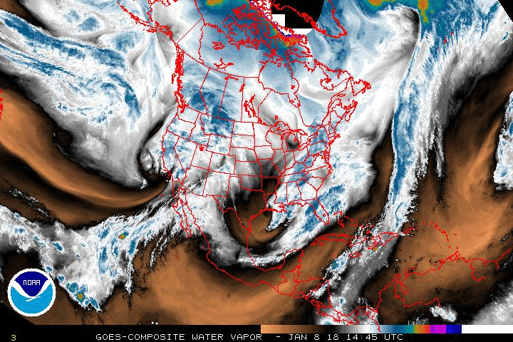
![]() by sroc4 Sat Dec 27, 2014 7:13 am
by sroc4 Sat Dec 27, 2014 7:13 am
Here is the current water vapor (WV) image and loop showing the actual current conditions as of 7am this morning. Take notice of a few things. 1) there is a deep tropical moisture connection (yellow arrows) 2) pay particular attention to the trough in the west. The trough def appears deeper and further off the SW coast/Baha; it also appears a tad sharper sharper, and the trough axis is slight less positive and def further west than where last nights 00z Euro has for this same time frame.
 " />
" />
 " />
" />Now I am not saying that this will have large impacts on our area for better or worse yet, but I am saying if the Euro is off with its forecast at hr 6 when compared to actual observations then its error only increases at its run continues. With other model guidance still bringing the precip closer to our area it leaves a small window for change over the next 24-48hrs potentially for the better. That is all carry on.
_________________
"In weather and in life, there's no winning and losing; there's only winning and learning."
WINTER 2012/2013 TOTALS 43.65"WINTER 2017/2018 TOTALS 62.85" WINTER 2022/2023 TOTALS 4.9"
WINTER 2013/2014 TOTALS 64.85"WINTER 2018/2019 TOTALS 14.25" WINTER 2023/2024 TOTALS 13.1"
WINTER 2014/2015 TOTALS 71.20"WINTER 2019/2020 TOTALS 6.35"
WINTER 2015/2016 TOTALS 35.00"WINTER 2020/2021 TOTALS 37.75"
WINTER 2016/2017 TOTALS 42.25"WINTER 2021/2022 TOTALS 31.65"
sroc4- Admin
- Posts : 8331
Reputation : 301
Join date : 2013-01-07
Location : Wading River, LI
Re: December 29th-30th Potential Overrunning event
![]() by jmanley32 Sat Dec 27, 2014 9:46 am
by jmanley32 Sat Dec 27, 2014 9:46 am

jmanley32- Senior Enthusiast
- Posts : 20516
Reputation : 108
Join date : 2013-12-12
Age : 42
Location : Yonkers, NY
Re: December 29th-30th Potential Overrunning event
![]() by Quietace Sat Dec 27, 2014 9:58 am
by Quietace Sat Dec 27, 2014 9:58 am
This is not a bad look. Surface temps are solid too(30-32).


Quietace- Meteorologist - Mod

- Posts : 3687
Reputation : 33
Join date : 2013-01-07
Age : 27
Location : Point Pleasant, NJ
Re: December 29th-30th Potential Overrunning event
![]() by Frank_Wx Sat Dec 27, 2014 10:58 am
by Frank_Wx Sat Dec 27, 2014 10:58 am
Nothing
_________________
_______________________________________________________________________________________________________
CLICK HERE to view NJ Strong Snowstorm Classifications
Frank_Wx- Godzilla Seeker
- Posts : 21305
Reputation : 328
Join date : 2013-01-05
Age : 31
Location : Jersey City, NJ -
Re: December 29th-30th Potential Overrunning event
![]() by sroc4 Sat Dec 27, 2014 11:12 am
by sroc4 Sat Dec 27, 2014 11:12 am
_________________
"In weather and in life, there's no winning and losing; there's only winning and learning."
WINTER 2012/2013 TOTALS 43.65"WINTER 2017/2018 TOTALS 62.85" WINTER 2022/2023 TOTALS 4.9"
WINTER 2013/2014 TOTALS 64.85"WINTER 2018/2019 TOTALS 14.25" WINTER 2023/2024 TOTALS 13.1"
WINTER 2014/2015 TOTALS 71.20"WINTER 2019/2020 TOTALS 6.35"
WINTER 2015/2016 TOTALS 35.00"WINTER 2020/2021 TOTALS 37.75"
WINTER 2016/2017 TOTALS 42.25"WINTER 2021/2022 TOTALS 31.65"
sroc4- Admin
- Posts : 8331
Reputation : 301
Join date : 2013-01-07
Location : Wading River, LI
Re: December 29th-30th Potential Overrunning event
![]() by sroc4 Sat Dec 27, 2014 12:02 pm
by sroc4 Sat Dec 27, 2014 12:02 pm
_________________
"In weather and in life, there's no winning and losing; there's only winning and learning."
WINTER 2012/2013 TOTALS 43.65"WINTER 2017/2018 TOTALS 62.85" WINTER 2022/2023 TOTALS 4.9"
WINTER 2013/2014 TOTALS 64.85"WINTER 2018/2019 TOTALS 14.25" WINTER 2023/2024 TOTALS 13.1"
WINTER 2014/2015 TOTALS 71.20"WINTER 2019/2020 TOTALS 6.35"
WINTER 2015/2016 TOTALS 35.00"WINTER 2020/2021 TOTALS 37.75"
WINTER 2016/2017 TOTALS 42.25"WINTER 2021/2022 TOTALS 31.65"
sroc4- Admin
- Posts : 8331
Reputation : 301
Join date : 2013-01-07
Location : Wading River, LI
Re: December 29th-30th Potential Overrunning event
![]() by amugs Sat Dec 27, 2014 12:25 pm
by amugs Sat Dec 27, 2014 12:25 pm
sroc4 wrote:And now with the CMC in.......(deep breath in through the nose and.....sigh)
Nada -what a frickin shame too warm

then to our south


_________________
Mugs
AKA:King: Snow Weenie
Self Proclaimed
WINTER 2014-15 : 55.12" +.02 for 6 coatings (avg. 35")
WINTER 2015-16 Total - 29.8" (Avg 35")
WINTER 2016-17 : 39.5" so far

amugs- Advanced Forecaster - Mod

- Posts : 15093
Reputation : 213
Join date : 2013-01-07
Age : 54
Location : Hillsdale,NJ
Re: December 29th-30th Potential Overrunning event
![]() by sroc4 Sat Dec 27, 2014 12:31 pm
by sroc4 Sat Dec 27, 2014 12:31 pm
amugs wrote:sroc4 wrote:And now with the CMC in.......(deep breath in through the nose and.....sigh)
Nada -what a frickin shame too warm
Yeah Mugs the 28th is when the front moves through. I never really expected anything but the liquid precip during this time frame. And it be light at that. But once the cold air moves through a second wave of energy was supposed to come up along the stalled front, but is unfort being surppressed by the cold arctic HP building in. So it looks like the 28th is too warm, and the 29th-30th is too cold (suppression depression) We need the baby bear...jjjjjust right. Unfort baby bear is grounded and cant come out and play. Look at the 12z NAM. Its still close, but unfort prob no cigar.

Last edited by sroc4 on Sat Dec 27, 2014 12:32 pm; edited 1 time in total
_________________
"In weather and in life, there's no winning and losing; there's only winning and learning."
WINTER 2012/2013 TOTALS 43.65"WINTER 2017/2018 TOTALS 62.85" WINTER 2022/2023 TOTALS 4.9"
WINTER 2013/2014 TOTALS 64.85"WINTER 2018/2019 TOTALS 14.25" WINTER 2023/2024 TOTALS 13.1"
WINTER 2014/2015 TOTALS 71.20"WINTER 2019/2020 TOTALS 6.35"
WINTER 2015/2016 TOTALS 35.00"WINTER 2020/2021 TOTALS 37.75"
WINTER 2016/2017 TOTALS 42.25"WINTER 2021/2022 TOTALS 31.65"
sroc4- Admin
- Posts : 8331
Reputation : 301
Join date : 2013-01-07
Location : Wading River, LI
Re: December 29th-30th Potential Overrunning event
![]() by Frank_Wx Sat Dec 27, 2014 12:31 pm
by Frank_Wx Sat Dec 27, 2014 12:31 pm
_________________
_______________________________________________________________________________________________________
CLICK HERE to view NJ Strong Snowstorm Classifications
Frank_Wx- Godzilla Seeker
- Posts : 21305
Reputation : 328
Join date : 2013-01-05
Age : 31
Location : Jersey City, NJ -
Page 5 of 6 • 1, 2, 3, 4, 5, 6 ![]()
|
|
|