
 Search
Sunday, January 18th Rain Storm
Page 4 of 5 •  1, 2, 3, 4, 5
 ![]()
Re: Sunday, January 18th Rain Storm
![]() by Quietace Sun Jan 18, 2015 11:59 am
by Quietace Sun Jan 18, 2015 11:59 am
Quietace- Meteorologist - Mod

- Posts : 3687
Join date : 2013-01-07
Re: Sunday, January 18th Rain Storm
![]() by skinsfan1177 Sun Jan 18, 2015 12:03 pm
by skinsfan1177 Sun Jan 18, 2015 12:03 pm
skinsfan1177- Senior Enthusiast

- Posts : 4485
Join date : 2013-01-07
Re: Sunday, January 18th Rain Storm
![]() by Frank_Wx Sun Jan 18, 2015 12:20 pm
by Frank_Wx Sun Jan 18, 2015 12:20 pm
sabamfa wrote:Any chance roads will clear later? How about the AM commute tomorrow? Looking at Passaic and Morris counties which are both a total mess now.
Temps are above freezing almost everywhere besides N&W of NYC. Tomorrow morning High's will get near 40 degrees. The biggest concern was always this morning.
_________________
_______________________________________________________________________________________________________
CLICK HERE to view NJ Strong Snowstorm Classifications

Frank_Wx- Godzilla Seeker

- Posts : 21305
Reputation : 328
Join date : 2013-01-05
Age : 31
Location : Jersey City, NJ -

Re: Sunday, January 18th Rain Storm
![]() by Dunnzoo Sun Jan 18, 2015 12:21 pm
by Dunnzoo Sun Jan 18, 2015 12:21 pm
_________________
Janet
Snowfall winter of 2023-2024 17.5"
Snowfall winter of 2022-2023 6.0"
Snowfall winter of 2021-2022 17.6" 1" sleet 2/25/22
Snowfall winter of 2020-2021 51.1"
Snowfall winter of 2019-2020 8.5"
Snowfall winter of 2018-2019 25.1"
Snowfall winter of 2017-2018 51.9"
Snowfall winter of 2016-2017 45.6"
Snowfall winter of 2015-2016 29.5"
Snowfall winter of 2014-2015 50.55"
Snowfall winter of 2013-2014 66.5"

Dunnzoo- Senior Enthusiast - Mod

- Posts : 4891
Reputation : 68
Join date : 2013-01-11
Age : 62
Location : Westwood, NJ
Re: Sunday, January 18th Rain Storm
![]() by jmanley32 Sun Jan 18, 2015 12:38 pm
by jmanley32 Sun Jan 18, 2015 12:38 pm

jmanley32- Senior Enthusiast
- Posts : 20516
Reputation : 108
Join date : 2013-12-12
Age : 42
Location : Yonkers, NY
Re: Sunday, January 18th Rain Storm
![]() by algae888 Sun Jan 18, 2015 12:40 pm
by algae888 Sun Jan 18, 2015 12:40 pm


algae888- Advanced Forecaster

- Posts : 5311
Reputation : 46
Join date : 2013-02-05
Age : 61
Location : mt. vernon, new york
Re: Sunday, January 18th Rain Storm
![]() by Dunnzoo Sun Jan 18, 2015 1:07 pm
by Dunnzoo Sun Jan 18, 2015 1:07 pm
jmanley32 wrote:.63 inches of ice! Thats a ice storm warning criteria not a advisory the NWS really did flop on this one, are there starting to be power outages up there some pretty heavy on the trees.
.63" of precip. ice accretion on trees and wires was about .10" but most of that has started to melt since we hit 33° a little while ago. Thank goodness there was no wind, we would have lost branches for sure. My total precip now is up to .74" with a lot more to come!
_________________
Janet
Snowfall winter of 2023-2024 17.5"
Snowfall winter of 2022-2023 6.0"
Snowfall winter of 2021-2022 17.6" 1" sleet 2/25/22
Snowfall winter of 2020-2021 51.1"
Snowfall winter of 2019-2020 8.5"
Snowfall winter of 2018-2019 25.1"
Snowfall winter of 2017-2018 51.9"
Snowfall winter of 2016-2017 45.6"
Snowfall winter of 2015-2016 29.5"
Snowfall winter of 2014-2015 50.55"
Snowfall winter of 2013-2014 66.5"
Dunnzoo- Senior Enthusiast - Mod
- Posts : 4891
Reputation : 68
Join date : 2013-01-11
Age : 62
Location : Westwood, NJ
Re: Sunday, January 18th Rain Storm
![]() by amugs Sun Jan 18, 2015 1:28 pm
by amugs Sun Jan 18, 2015 1:28 pm
Last night driving home on route in nnj and they were spreading brine down for this morning and it would be icy when they do this on major roads/highways.
_________________
Mugs
AKA:King: Snow Weenie
Self Proclaimed
WINTER 2014-15 : 55.12" +.02 for 6 coatings (avg. 35")
WINTER 2015-16 Total - 29.8" (Avg 35")
WINTER 2016-17 : 39.5" so far

amugs- Advanced Forecaster - Mod
- Posts : 15093
Reputation : 213
Join date : 2013-01-07
Age : 54
Location : Hillsdale,NJ
Re: Sunday, January 18th Rain Storm
![]() by Frank_Wx Sun Jan 18, 2015 1:29 pm
by Frank_Wx Sun Jan 18, 2015 1:29 pm
Madonne.
_________________
_______________________________________________________________________________________________________
CLICK HERE to view NJ Strong Snowstorm Classifications
Frank_Wx- Godzilla Seeker
- Posts : 21305
Reputation : 328
Join date : 2013-01-05
Age : 31
Location : Jersey City, NJ -
Re: Sunday, January 18th Rain Storm
![]() by Dunnzoo Sun Jan 18, 2015 1:30 pm
by Dunnzoo Sun Jan 18, 2015 1:30 pm
_________________
Janet
Snowfall winter of 2023-2024 17.5"
Snowfall winter of 2022-2023 6.0"
Snowfall winter of 2021-2022 17.6" 1" sleet 2/25/22
Snowfall winter of 2020-2021 51.1"
Snowfall winter of 2019-2020 8.5"
Snowfall winter of 2018-2019 25.1"
Snowfall winter of 2017-2018 51.9"
Snowfall winter of 2016-2017 45.6"
Snowfall winter of 2015-2016 29.5"
Snowfall winter of 2014-2015 50.55"
Snowfall winter of 2013-2014 66.5"
Dunnzoo- Senior Enthusiast - Mod
- Posts : 4891
Reputation : 68
Join date : 2013-01-11
Age : 62
Location : Westwood, NJ
Re: Sunday, January 18th Rain Storm
![]() by Frank_Wx Sun Jan 18, 2015 1:32 pm
by Frank_Wx Sun Jan 18, 2015 1:32 pm
_________________
_______________________________________________________________________________________________________
CLICK HERE to view NJ Strong Snowstorm Classifications
Frank_Wx- Godzilla Seeker
- Posts : 21305
Reputation : 328
Join date : 2013-01-05
Age : 31
Location : Jersey City, NJ -
Re: Sunday, January 18th Rain Storm
![]() by Frank_Wx Sun Jan 18, 2015 1:51 pm
by Frank_Wx Sun Jan 18, 2015 1:51 pm
_________________
_______________________________________________________________________________________________________
CLICK HERE to view NJ Strong Snowstorm Classifications
Frank_Wx- Godzilla Seeker
- Posts : 21305
Reputation : 328
Join date : 2013-01-05
Age : 31
Location : Jersey City, NJ -
Re: Sunday, January 18th Rain Storm
![]() by Frank_Wx Sun Jan 18, 2015 1:56 pm
by Frank_Wx Sun Jan 18, 2015 1:56 pm

_________________
_______________________________________________________________________________________________________
CLICK HERE to view NJ Strong Snowstorm Classifications
Frank_Wx- Godzilla Seeker
- Posts : 21305
Reputation : 328
Join date : 2013-01-05
Age : 31
Location : Jersey City, NJ -
Re: Sunday, January 18th Rain Storm
![]() by Math23x7 Sun Jan 18, 2015 1:57 pm
by Math23x7 Sun Jan 18, 2015 1:57 pm
Frank_Wx wrote:My street is completely flooded. At least my car gets a wash to remove the salt.
Is that Cranford or Parsippany?
Math23x7- Wx Statistician Guru

- Posts : 2379
Reputation : 68
Join date : 2013-01-08
Re: Sunday, January 18th Rain Storm
![]() by Frank_Wx Sun Jan 18, 2015 2:02 pm
by Frank_Wx Sun Jan 18, 2015 2:02 pm
_________________
_______________________________________________________________________________________________________
CLICK HERE to view NJ Strong Snowstorm Classifications
Frank_Wx- Godzilla Seeker
- Posts : 21305
Reputation : 328
Join date : 2013-01-05
Age : 31
Location : Jersey City, NJ -
Re: Sunday, January 18th Rain Storm
![]() by algae888 Sun Jan 18, 2015 2:02 pm
by algae888 Sun Jan 18, 2015 2:02 pm
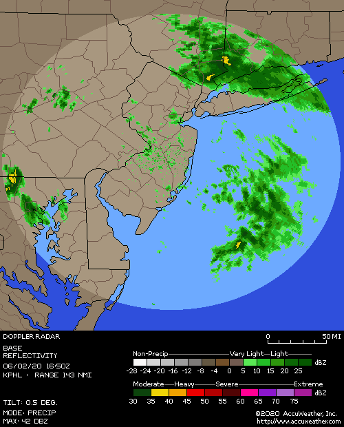
INTENSE COASTAL FRONT SITS FROM JUST S OF NYC ACROSS LONG ISLAND
AND INTO SE CT. TEMPS ARE ARE IN THE 40S TO NEAR 50 TO ITS S...AND
IN THE UPPER 20S AND LOWER 30S IN MANY PLACES TO ITS N. THIS FRONT
IS FCST BY THE 12Z NAM TO MOVE SLOWLY NW-WARD THIS AFTERNOON
THROUGH NYC AND SOUTHERN CT...WHILE AREAS TO THE NW REMAIN IN THE
COLD SECTOR...AND TEMPS WELL TO THE WEST OF NYC MAY STRUGGLE TO REACH
FREEZING THIS AFTERNOON...WITH ANY SLOW WARMING OCCURRING VIA
FALLING RAIN ALOFT AS ANY COLD AIR REPLENISHMENT VIA NORTHERLY
FLOW REMAINS QUITE WEAK. HAVE ADJUSTED FREEZING RAIN ADVYS
ACCORDINGLY...LASTING ACROSS MOST OF THE INTERIOR UNTIL 18Z...AND
ACROSS ORANGE/PASSAIC/W BERGEN/ROCKLAND UNTIL 20Z. IT IS POSSIBLE
THAT TEMPS IN THIS LATTER AREA MAY NEVER WARM MUCH ABOVE
FREEZING...WHICH ALONG WITH HEAVY RAIN MOVING IN FROM THE SOUTH
THIS AFTERNOON MAY KEEP THE FREEZING RAIN THREAT GOING LONG ENOUGH
TO REQUIRE A SHORT FUSED ICE STORM WARNING. AT ANY RATE...GIVEN
VERY COLD GROUND TEMPS IN MOST PLACES...AIR TEMPS MAY HAVE TO
REACH THE MID 30S BEFORE THE ICING THREAT SUBSIDES.
INCREASING ISENTROPIC LIFT...ARRIVAL OF 50-60KT 950-850 HPA JET
BY AROUND MIDDAY...AND THE REGION BEING IN THE RIGHT REAR QUADRANT
OF A STRENGTHENING 120-140KT 300 HPA JET THIS AFTERNOON...WILL
BRING MODERATE TO LOCALLY HEAVY RAINFALL TO THE AREA THIS
AFTERNOON INTO EARLY THIS EVENING. THERE IS ALSO A SMALL CHANCE
FOR AN ISOLATED RUMBLE OF THUNDER OVER E ZONES...AS THE SHOWALTER
INDEX IS FORECAST TO GET DOWN TO AROUND 2 THERE. PRECIPITATION
WILL TAPER OFF FROM SW TO NE AS THE SURFACE LOW LIFTS TO THE NE
LATER THIS EVENING/EARLY OVERNIGHT. REFER TO THE HYDROLOGY SECTION
OF THE AFD FOR STORM TOTAL RAINFALL AND ANY IMPACTS.
THERE IS A POSSIBILITY THAT ENOUGH LOW LEVEL COLD AIR
COULD MOVE IN ACROSS INTERIOR ZONES BEFORE THE PRECIPITATION ENDS
TO HAVE IT MIX WITH OR CHANGE TO SNOW THERE BEFORE ENDING.
algae888- Advanced Forecaster
- Posts : 5311
Reputation : 46
Join date : 2013-02-05
Age : 61
Location : mt. vernon, new york
Re: Sunday, January 18th Rain Storm
![]() by Dtone Sun Jan 18, 2015 2:21 pm
by Dtone Sun Jan 18, 2015 2:21 pm
THE NATIONAL WEATHER SERVICE IN UPTON NY HAS ISSUED A
* FLOOD WARNING FOR URBAN AREAS IN...
RICHMOND (STATEN ISLAND) COUNTY IN SOUTHEAST NEW YORK...
BRONX COUNTY IN SOUTHEAST NEW YORK...
NEW YORK (MANHATTAN) COUNTY IN SOUTHEAST NEW YORK...
NASSAU COUNTY IN SOUTHEAST NEW YORK...
QUEENS COUNTY IN SOUTHEAST NEW YORK...
KINGS (BROOKLYN) COUNTY IN SOUTHEAST NEW YORK...
* UNTIL 600 PM EST
* AT 203 PM EST DOPPLER RADAR INDICATED MODERATE TO HEAVY RAIN
MOVING INTO THE WARNING AREA. MANY LOCATIONS HAVE ALREADY OBSERVED
AN INCH OR MORE OF RAIN. AN ADDITIONAL INCH IS EXPECTED.
* WIDESPREAD URBAN AND POOR DRAINAGE FLOODING IS EXPECTED. THE BRONX
RIVER IS EXPECTED TO APPROACH OR EXCEED FLOOD THRESHOLDS.
A FLOOD WARNING MEANS THAT FLOODING IS IMMINENT OR HAS BEEN REPORTED.
STREAM RISES WILL BE SLOW AND FLASH FLOODING IS NOT EXPECTED.
HOWEVER...ALL INTERESTED PARTIES SHOULD TAKE NECESSARY PRECAUTIONS
IMMEDIATELY.
Dtone- Wx Statistician Guru
- Posts : 1738
Reputation : 9
Join date : 2013-08-26
Location : Bronx, NY
Re: Sunday, January 18th Rain Storm
![]() by Frank_Wx Sun Jan 18, 2015 2:27 pm
by Frank_Wx Sun Jan 18, 2015 2:27 pm
_________________
_______________________________________________________________________________________________________
CLICK HERE to view NJ Strong Snowstorm Classifications
Frank_Wx- Godzilla Seeker
- Posts : 21305
Reputation : 328
Join date : 2013-01-05
Age : 31
Location : Jersey City, NJ -
Re: Sunday, January 18th Rain Storm
![]() by SoulSingMG Sun Jan 18, 2015 2:40 pm
by SoulSingMG Sun Jan 18, 2015 2:40 pm
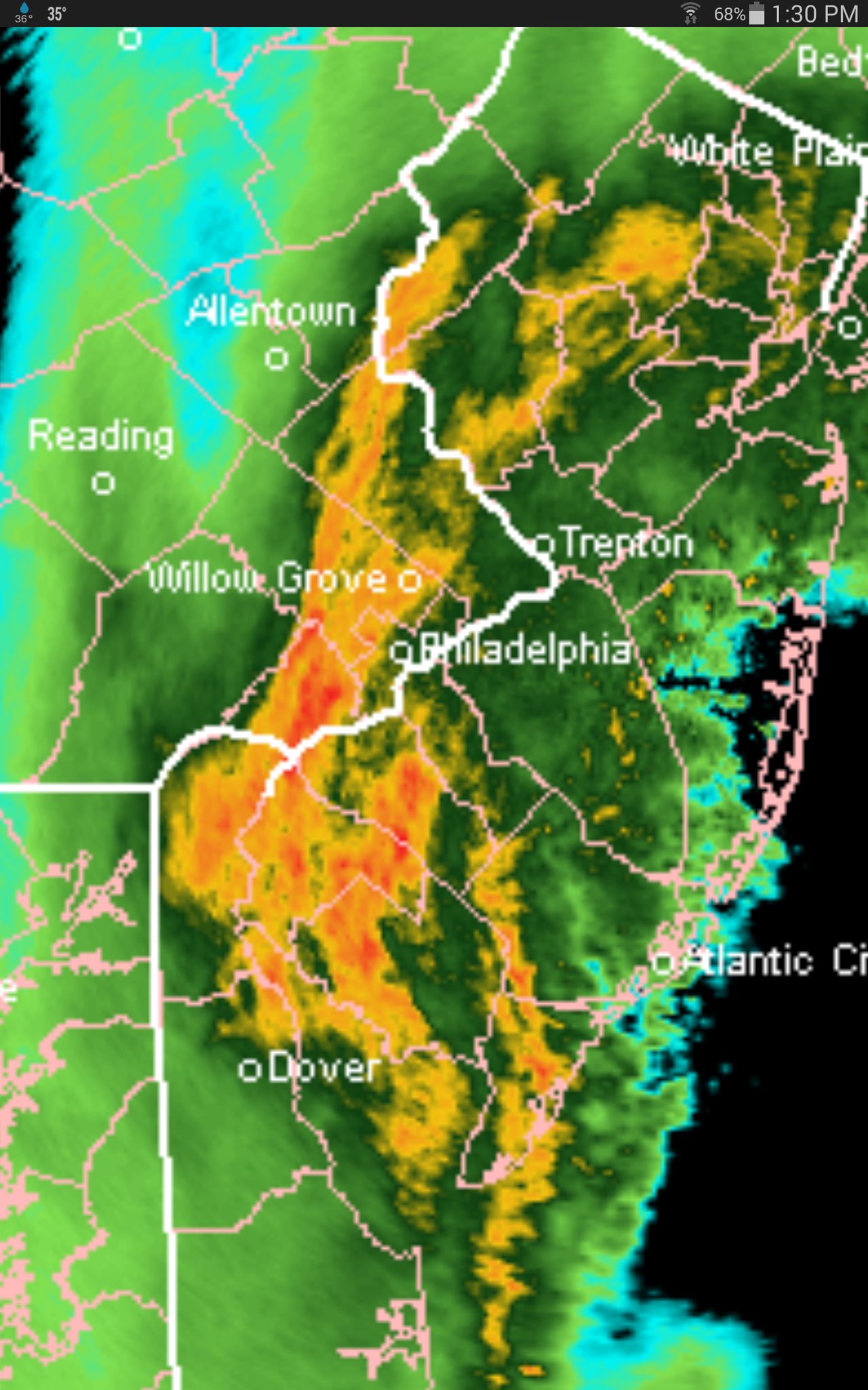
Frank_Wx wrote:Wow 55 dbz band in North central NJ
A Flood Warning on January 18th. I can't.

SoulSingMG- Senior Enthusiast
- Posts : 2853
Reputation : 74
Join date : 2013-12-11
Location : Long Island City, NY
Re: Sunday, January 18th Rain Storm
![]() by jmanley32 Sun Jan 18, 2015 3:03 pm
by jmanley32 Sun Jan 18, 2015 3:03 pm
Al what part of CC parkway was that, looks like that was a catastrophic accident fatalities?
jmanley32- Senior Enthusiast
- Posts : 20516
Reputation : 108
Join date : 2013-12-12
Age : 42
Location : Yonkers, NY
Re: Sunday, January 18th Rain Storm
![]() by jmanley32 Sun Jan 18, 2015 3:04 pm
by jmanley32 Sun Jan 18, 2015 3:04 pm
jmanley32- Senior Enthusiast
- Posts : 20516
Reputation : 108
Join date : 2013-12-12
Age : 42
Location : Yonkers, NY
Re: Sunday, January 18th Rain Storm
![]() by amugs Sun Jan 18, 2015 3:27 pm
by amugs Sun Jan 18, 2015 3:27 pm
_________________
Mugs
AKA:King: Snow Weenie
Self Proclaimed
WINTER 2014-15 : 55.12" +.02 for 6 coatings (avg. 35")
WINTER 2015-16 Total - 29.8" (Avg 35")
WINTER 2016-17 : 39.5" so far
amugs- Advanced Forecaster - Mod
- Posts : 15093
Reputation : 213
Join date : 2013-01-07
Age : 54
Location : Hillsdale,NJ
Re: Sunday, January 18th Rain Storm
![]() by SoulSingMG Sun Jan 18, 2015 3:35 pm
by SoulSingMG Sun Jan 18, 2015 3:35 pm
amugs wrote:The NWS fd up this storm imo up here in nnj I am at 35.6* now and we had heavy icing up here and points north. Now a flood advisory then a changeover back to wintry weather. And to think some models showed a dry weekend. This is how BAD models again imho have been all winter and late fall long.
I totally agree. I can't remember models being this horribly spread.
SoulSingMG- Senior Enthusiast
- Posts : 2853
Reputation : 74
Join date : 2013-12-11
Location : Long Island City, NY
Re: Sunday, January 18th Rain Storm
![]() by nutleyblizzard Sun Jan 18, 2015 3:35 pm
by nutleyblizzard Sun Jan 18, 2015 3:35 pm

nutleyblizzard- Senior Enthusiast
- Posts : 1952
Reputation : 41
Join date : 2014-01-30
Age : 58
Location : Nutley, new jersey
Re: Sunday, January 18th Rain Storm
![]() by Frank_Wx Sun Jan 18, 2015 3:36 pm
by Frank_Wx Sun Jan 18, 2015 3:36 pm
_________________
_______________________________________________________________________________________________________
CLICK HERE to view NJ Strong Snowstorm Classifications
Frank_Wx- Godzilla Seeker
- Posts : 21305
Reputation : 328
Join date : 2013-01-05
Age : 31
Location : Jersey City, NJ -
Re: Sunday, January 18th Rain Storm
![]() by essexcountypete Sun Jan 18, 2015 3:53 pm
by essexcountypete Sun Jan 18, 2015 3:53 pm
Because why the hell not.

essexcountypete- Pro Enthusiast

- Posts : 783
Reputation : 12
Join date : 2013-12-09
Location : Bloomfield, NJ
Re: Sunday, January 18th Rain Storm
![]() by Frank_Wx Sun Jan 18, 2015 4:08 pm
by Frank_Wx Sun Jan 18, 2015 4:08 pm

Quickly exiting. Seems sooner than expected which means maybe this will give our clipper more space Wednesday to come further north. Rain should end around 6pm
_________________
_______________________________________________________________________________________________________
CLICK HERE to view NJ Strong Snowstorm Classifications
Frank_Wx- Godzilla Seeker
- Posts : 21305
Reputation : 328
Join date : 2013-01-05
Age : 31
Location : Jersey City, NJ -
Page 4 of 5 • 1, 2, 3, 4, 5 ![]()
|
|
|