
 Search
Update #4: Final Call Snow Map
Page 1 of 40 • 1, 2, 3 ... 20 ... 40 ![]()

Update #1: The Making of a Godzilla? (1/24/15)
![]() by Frank_Wx Tue Jan 20, 2015 7:12 pm
by Frank_Wx Tue Jan 20, 2015 7:12 pm
1. A "Godzilla" is classified as a widespread 12"+ snowstorm. The possible storm this Saturday does have that type of ceiling.
2. I'm not calling for a Godzilla. It's possible this storm goes out to sea, but maybe if we analyze the pattern we'll have a better idea than the models.
3. I'm doing something a little different (now that I'm working full-time) where I will have a new Update every day leading up to the possible storm. You can expect these between 6-8pm.
The 12z GFS Model:

The GFS model has a healthy coastal storm bringing moderate to heavy snow to the area Saturday. Lets take a look at some upper air images:
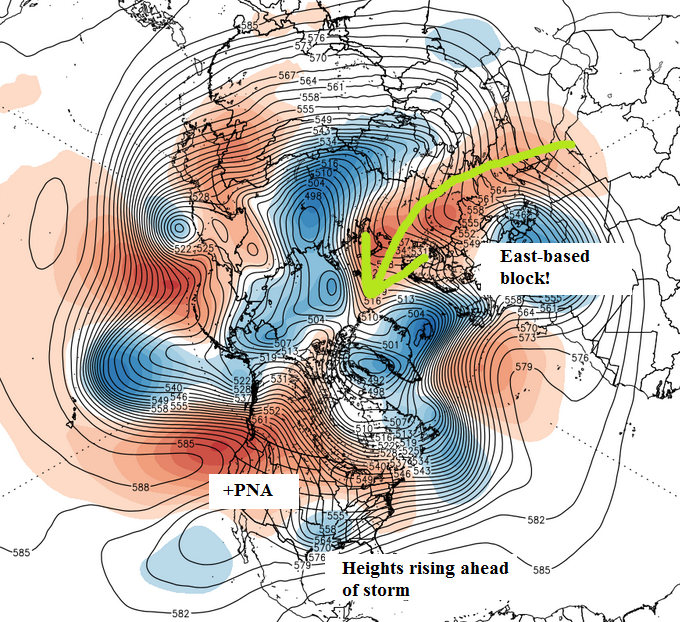
This height anomaly map from the GEFS show east-based blocking pressing down over the NAO region. It's certainly not a great block, but between the Atlantic and Scandinavian ridge that will help slow down the northern stream jet and possibly slow down the flow enough to promote a phase between both jets on Saturday.

Wednesday we are going to see the sub tropical jet stream energy phase with pacific energy in the SW CONUS. The collapsing ridge helps eject that vort east.

Fast forward to Saturday and you see the mean trough, or energy, settled over the southeast with northern stream energy getting ready to dive south. This is huge, because models were originally not showing much northern stream interaction. There's some confluence over the northeast getting ready to move out. The quicker it does, the better, so heights can rise along the coast.
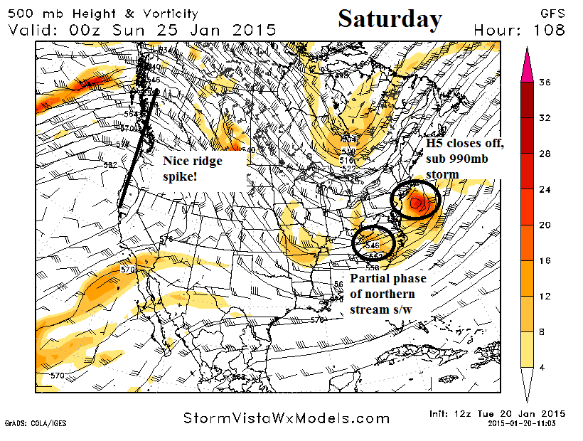
Saturday is the day this storm would hit. The GFS on this run did not complete a full phase with the northern stream energy into the mean trough, but there is some partial phasing that helps invigorate the storm. A full phase would bring out a stronger storm closer to the coast. Remember when the ridge collapsed on Wednesday? Check out how it rebounds by Saturday as the storm comes together. This is one of the big reasons why we're seeing northern stream s/w's get involved.
One other thing to note and I should have circled it is the other piece of H5 energy over Arkansas. If that energy amplifies too much, it may try to act as a "kicker" and keep our coastal storm further out to sea. Ideally we would like to see all that energy phased into the mean trough, but I do not think that will be the case. Instead, we have to try and get the southern energy to either slow down, or the northern energy to speed up. This actually has a good chance of happening because the northern stream this season has been pretty fast in nature, so the possibility of a full phase still exists.
The 12z EURO Model

The EURO model is a bit further east than the GFS, but not by much. The precip. shield is more expansive and the southern energy is stronger on H5. Overall, the end solution is quite similar.
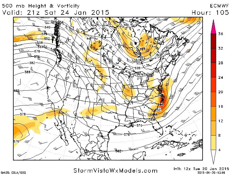
H5, however, is kind of different compared to the GFS. Notice how H5 never closes off on the EURO. The northern stream energy is also lagging further behind, whereas the GFS had some partial phasing. This is where the risk of an out to sea solution comes into play. If heights remain flat along the east coast and there is no northern stream interaction, the trough will not buckle and the storm is one for the fishes. Both major models are not showing this right now, but it's a solution STILL ON THE TABLE.
Personally, I think as long as we have that east-based block with an amplifying western ridge, there will be some northern stream interaction to one degree or another and we'll see some form of a storm off the coast. How strong it gets, what kind of precipitation it brings, and the duration all remain in question.
This was a quick look at the overall set-up. I'll be sure to keep you all informed with the latest trends.
Confidence:
Out to sea- 40%
Hit - 60%
We'll see what happens!
Last edited by Frank_Wx on Wed Jan 21, 2015 7:26 pm; edited 1 time in total
_________________
_______________________________________________________________________________________________________
CLICK HERE to view NJ Strong Snowstorm Classifications

Frank_Wx- Godzilla Seeker

- Posts : 21305
Reputation : 328
Join date : 2013-01-05
Age : 31
Location : Jersey City, NJ -

Re: Update #4: Final Call Snow Map
![]() by amugs Tue Jan 20, 2015 7:44 pm
by amugs Tue Jan 20, 2015 7:44 pm
_________________
Mugs
AKA:King: Snow Weenie
Self Proclaimed
WINTER 2014-15 : 55.12" +.02 for 6 coatings (avg. 35")
WINTER 2015-16 Total - 29.8" (Avg 35")
WINTER 2016-17 : 39.5" so far

amugs- Advanced Forecaster - Mod

- Posts : 15093
Reputation : 213
Join date : 2013-01-07
Age : 54
Location : Hillsdale,NJ
Re: Update #4: Final Call Snow Map
![]() by Guest Tue Jan 20, 2015 7:45 pm
by Guest Tue Jan 20, 2015 7:45 pm
Guest- Guest
Re: Update #4: Final Call Snow Map
![]() by devsman Tue Jan 20, 2015 7:47 pm
by devsman Tue Jan 20, 2015 7:47 pm

devsman- Pro Enthusiast

- Posts : 424
Reputation : 4
Join date : 2014-01-01
Age : 48
Location : merrick, ny (south shore of Long Island)
Re: Update #4: Final Call Snow Map
![]() by Quietace Tue Jan 20, 2015 8:05 pm
by Quietace Tue Jan 20, 2015 8:05 pm
I have $1devsman wrote:Not sure I like this "Working Man" Frank with one update at night. Let's just take a collection and pay Frank for his input into the weather scene.

Quietace- Meteorologist - Mod

- Posts : 3687
Reputation : 33
Join date : 2013-01-07
Age : 27
Location : Point Pleasant, NJ
Re: Update #4: Final Call Snow Map
![]() by devsman Tue Jan 20, 2015 8:08 pm
by devsman Tue Jan 20, 2015 8:08 pm
I still like the mon-tuesday storm more than this one. Have a feeling this will be more wet than white along the coast...(Don't BAN ME). But Hopefully a day off for me is in the future.
devsman- Pro Enthusiast
- Posts : 424
Reputation : 4
Join date : 2014-01-01
Age : 48
Location : merrick, ny (south shore of Long Island)
Re: Update #4: Final Call Snow Map
![]() by jmanley32 Tue Jan 20, 2015 8:09 pm
by jmanley32 Tue Jan 20, 2015 8:09 pm

jmanley32- Senior Enthusiast

- Posts : 20516
Reputation : 108
Join date : 2013-12-12
Age : 42
Location : Yonkers, NY
Re: Update #4: Final Call Snow Map
![]() by jmanley32 Tue Jan 20, 2015 8:14 pm
by jmanley32 Tue Jan 20, 2015 8:14 pm
My friend who is very much into astrology (and it has oddly verified before, somewhat earrily) said in response to this Me: "do you think this mercury retrograde will give us the big snowstorm we are hoping for?" He said "if you want to be buried in your home without power, I would be prepared for the worst" (or the best in our view) lol.
jmanley32- Senior Enthusiast
- Posts : 20516
Reputation : 108
Join date : 2013-12-12
Age : 42
Location : Yonkers, NY
Re: Update #4: Final Call Snow Map
![]() by Frank_Wx Tue Jan 20, 2015 8:40 pm
by Frank_Wx Tue Jan 20, 2015 8:40 pm
devsman wrote:I'm a teacher so I can throw in $2 and a 12 pack of pencils.
I still like the mon-tuesday storm more than this one. Have a feeling this will be more wet than white along the coast...(Don't BAN ME). But Hopefully a day off for me is in the future.
I like that storm too. A full latitude trough.
_________________
_______________________________________________________________________________________________________
CLICK HERE to view NJ Strong Snowstorm Classifications
Frank_Wx- Godzilla Seeker
- Posts : 21305
Reputation : 328
Join date : 2013-01-05
Age : 31
Location : Jersey City, NJ -
Re: Update #4: Final Call Snow Map
![]() by devsman Tue Jan 20, 2015 8:44 pm
by devsman Tue Jan 20, 2015 8:44 pm
devsman- Pro Enthusiast
- Posts : 424
Reputation : 4
Join date : 2014-01-01
Age : 48
Location : merrick, ny (south shore of Long Island)
Re: Update #4: Final Call Snow Map
![]() by jmanley32 Tue Jan 20, 2015 8:54 pm
by jmanley32 Tue Jan 20, 2015 8:54 pm
jmanley32- Senior Enthusiast
- Posts : 20516
Reputation : 108
Join date : 2013-12-12
Age : 42
Location : Yonkers, NY
Re: Update #4: Final Call Snow Map
![]() by amugs Tue Jan 20, 2015 9:05 pm
by amugs Tue Jan 20, 2015 9:05 pm
BUT i will take this to help out the next one IMO.
_________________
Mugs
AKA:King: Snow Weenie
Self Proclaimed
WINTER 2014-15 : 55.12" +.02 for 6 coatings (avg. 35")
WINTER 2015-16 Total - 29.8" (Avg 35")
WINTER 2016-17 : 39.5" so far
amugs- Advanced Forecaster - Mod
- Posts : 15093
Reputation : 213
Join date : 2013-01-07
Age : 54
Location : Hillsdale,NJ
Re: Update #4: Final Call Snow Map
![]() by jmanley32 Tue Jan 20, 2015 9:07 pm
by jmanley32 Tue Jan 20, 2015 9:07 pm
jmanley32- Senior Enthusiast
- Posts : 20516
Reputation : 108
Join date : 2013-12-12
Age : 42
Location : Yonkers, NY
Re: Update #4: Final Call Snow Map
![]() by devsman Tue Jan 20, 2015 9:10 pm
by devsman Tue Jan 20, 2015 9:10 pm
jmanley32 wrote:hey mugs why not shoot for 2 godzillas in a 3-5 day period, when was the last time that happened, who knows maybe the second will be a roid, some of the euro ensembles have feet of snow by the 28th fyi.
Feb of 1996. That was amazing!
devsman- Pro Enthusiast
- Posts : 424
Reputation : 4
Join date : 2014-01-01
Age : 48
Location : merrick, ny (south shore of Long Island)
Re: Update #4: Final Call Snow Map
![]() by SoulSingMG Tue Jan 20, 2015 9:57 pm
by SoulSingMG Tue Jan 20, 2015 9:57 pm
devsman wrote:jmanley32 wrote:hey mugs why not shoot for 2 godzillas in a 3-5 day period, when was the last time that happened, who knows maybe the second will be a roid, some of the euro ensembles have feet of snow by the 28th fyi.
Feb of 1996. That was amazing!
Hearing the 00z NAM is a hit. (one way or the other...)

SoulSingMG- Senior Enthusiast
- Posts : 2853
Reputation : 74
Join date : 2013-12-11
Location : Long Island City, NY
Re: Update #4: Final Call Snow Map
![]() by jmanley32 Tue Jan 20, 2015 9:59 pm
by jmanley32 Tue Jan 20, 2015 9:59 pm
jmanley32- Senior Enthusiast
- Posts : 20516
Reputation : 108
Join date : 2013-12-12
Age : 42
Location : Yonkers, NY
Re: Update #4: Final Call Snow Map
![]() by skinsfan1177 Tue Jan 20, 2015 10:01 pm
by skinsfan1177 Tue Jan 20, 2015 10:01 pm

skinsfan1177- Senior Enthusiast
- Posts : 4485
Reputation : 35
Join date : 2013-01-07
Age : 46
Location : Point Pleasant Boro
Re: Update #4: Final Call Snow Map
![]() by SoulSingMG Tue Jan 20, 2015 10:02 pm
by SoulSingMG Tue Jan 20, 2015 10:02 pm
jmanley32 wrote:Yes it is, not far enough out yet and not reliable at this range but still, and btw it has 4-6 tomorrow in southern jersey!
Southeast NJ may really over-perform tomorrow. History kinda predicts this too, with these sorta systems.
NAM is out-of-range but it's worth looking at. I really think this system will be a sloppy mess for many without any true inject of cold air. Not to say there can't/won't be accumulating snow. Just gotta watch that r/s line. JUST to the west of it will be the biggest totals. And then #1 passes to set us up for a biggie on Tuesday...?

SoulSingMG- Senior Enthusiast
- Posts : 2853
Reputation : 74
Join date : 2013-12-11
Location : Long Island City, NY
Re: Update #4: Final Call Snow Map
![]() by skinsfan1177 Tue Jan 20, 2015 10:06 pm
by skinsfan1177 Tue Jan 20, 2015 10:06 pm
skinsfan1177- Senior Enthusiast
- Posts : 4485
Reputation : 35
Join date : 2013-01-07
Age : 46
Location : Point Pleasant Boro
Re: Update #4: Final Call Snow Map
![]() by Frank_Wx Tue Jan 20, 2015 10:08 pm
by Frank_Wx Tue Jan 20, 2015 10:08 pm
_________________
_______________________________________________________________________________________________________
CLICK HERE to view NJ Strong Snowstorm Classifications
Frank_Wx- Godzilla Seeker
- Posts : 21305
Reputation : 328
Join date : 2013-01-05
Age : 31
Location : Jersey City, NJ -
Re: Update #4: Final Call Snow Map
![]() by sroc4 Tue Jan 20, 2015 10:10 pm
by sroc4 Tue Jan 20, 2015 10:10 pm
Frank_Wx wrote:Screw the NAM. 00z GFS commencing soon. I'll have a play by play
You and the NAM should totally get it on Frank. It's so obvious your in love
_________________
"In weather and in life, there's no winning and losing; there's only winning and learning."
WINTER 2012/2013 TOTALS 43.65"WINTER 2017/2018 TOTALS 62.85" WINTER 2022/2023 TOTALS 4.9"
WINTER 2013/2014 TOTALS 64.85"WINTER 2018/2019 TOTALS 14.25" WINTER 2023/2024 TOTALS 13.1"
WINTER 2014/2015 TOTALS 71.20"WINTER 2019/2020 TOTALS 6.35"
WINTER 2015/2016 TOTALS 35.00"WINTER 2020/2021 TOTALS 37.75"
WINTER 2016/2017 TOTALS 42.25"WINTER 2021/2022 TOTALS 31.65"

sroc4- Admin
- Posts : 8331
Reputation : 301
Join date : 2013-01-07
Location : Wading River, LI
Re: Update #4: Final Call Snow Map
![]() by SoulSingMG Tue Jan 20, 2015 10:11 pm
by SoulSingMG Tue Jan 20, 2015 10:11 pm
Frank_Wx wrote:Screw the NAM. 00z GFS commencing soon. I'll have a play by play
Lol! I am just sayyyyyying, at least it doesn't show a miss or something. Read this on another site about it:
'The surface at KNYC is 32 at hour 84
If there was a next frame to the NAM
Everyone would be flipping back to heavy snow and blizzard conditions would occur all the way to the coast.
The NAM surges the 850's N but once that SLP gets to about Asbury the winds turn NE and the whole column collapses .
Look at the VV the system is a beast.'
SoulSingMG- Senior Enthusiast
- Posts : 2853
Reputation : 74
Join date : 2013-12-11
Location : Long Island City, NY
Re: Update #4: Final Call Snow Map
![]() by jmanley32 Tue Jan 20, 2015 10:11 pm
by jmanley32 Tue Jan 20, 2015 10:11 pm
jmanley32- Senior Enthusiast
- Posts : 20516
Reputation : 108
Join date : 2013-12-12
Age : 42
Location : Yonkers, NY
Re: Update #4: Final Call Snow Map
![]() by Frank_Wx Tue Jan 20, 2015 10:12 pm
by Frank_Wx Tue Jan 20, 2015 10:12 pm
sroc4 wrote:Frank_Wx wrote:Screw the NAM. 00z GFS commencing soon. I'll have a play by play
You and the NAM should totally get it on Frank. It's so obvious your in love
Only European models turn me on.
Not the software
_________________
_______________________________________________________________________________________________________
CLICK HERE to view NJ Strong Snowstorm Classifications
Frank_Wx- Godzilla Seeker
- Posts : 21305
Reputation : 328
Join date : 2013-01-05
Age : 31
Location : Jersey City, NJ -
Re: Update #4: Final Call Snow Map
![]() by jmanley32 Tue Jan 20, 2015 10:13 pm
by jmanley32 Tue Jan 20, 2015 10:13 pm
jmanley32- Senior Enthusiast
- Posts : 20516
Reputation : 108
Join date : 2013-12-12
Age : 42
Location : Yonkers, NY
Page 1 of 40 • 1, 2, 3 ... 20 ... 40 ![]()
|
|
|