
 Search
3/20 Spring Snowstorm Observations / Final Call Snow Map
Page 18 of 19 •  1 ... 10 ... 17, 18, 19
 ![]()
Re: 3/20 Spring Snowstorm Observations / Final Call Snow Map
![]() by nofoboater Sat Mar 21, 2015 7:48 am
by nofoboater Sat Mar 21, 2015 7:48 am
Side note: I'm not a tremendously big poster here but thought it might be appropriate to send heart felt condolences to the family of Lisa Colagrassi and channel 7 Eyewitness News Team. Definitely too young to leave us.
-Nofo
nofoboater- Posts : 319
Join date : 2013-08-19
Re: 3/20 Spring Snowstorm Observations / Final Call Snow Map
![]() by Frank_Wx Sat Mar 21, 2015 7:50 am
by Frank_Wx Sat Mar 21, 2015 7:50 am
Frank_Wx wrote:

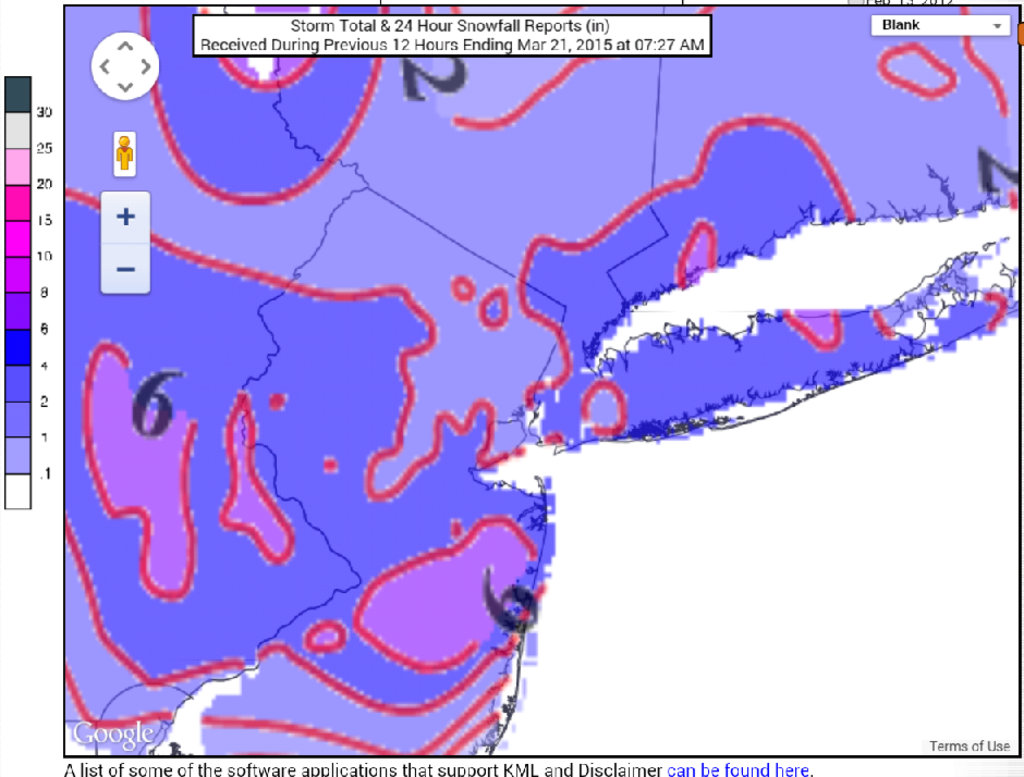
Numerous reports of 3-6" across the area with isolated 7" amounts in LI and EPA. If I had moved the 3-6 south to encompass CNJ and the jersey shore, it would have been a good call by me. Alas, I busted too low. Still, compared to some other sources I thought I was one of the highest along with Nick Gregory on FOX. Sun angle was a factor until mid afternoon, but once rates picked up and dawn came it was game on from there.
Frank_Wx- Godzilla Seeker

- Posts : 21305
Join date : 2013-01-05 -

Re: 3/20 Spring Snowstorm Observations / Final Call Snow Map
![]() by amugs Sat Mar 21, 2015 8:07 am
by amugs Sat Mar 21, 2015 8:07 am
30* and overcast what a storm.If it came at dawn to dusk we'd be waking up to more accumulations and if it were the middle of winter we'd have even more.
Mike those are incredible stats for Cpk you posted above.
what are the three year totals?
_________________
Mugs
AKA:King: Snow Weenie
Self Proclaimed
WINTER 2014-15 : 55.12" +.02 for 6 coatings (avg. 35")
WINTER 2015-16 Total - 29.8" (Avg 35")
WINTER 2016-17 : 39.5" so far

amugs- Advanced Forecaster - Mod

- Posts : 15093
Reputation : 213
Join date : 2013-01-07
Age : 54
Location : Hillsdale,NJ
Re: 3/20 Spring Snowstorm Observations / Final Call Snow Map
![]() by snow247 Sat Mar 21, 2015 8:14 am
by snow247 Sat Mar 21, 2015 8:14 am

snow247- Pro Enthusiast

- Posts : 2417
Reputation : 0
Join date : 2014-08-27
Location : Mount Ivy, NY - Elevation 545'
Re: 3/20 Spring Snowstorm Observations / Final Call Snow Map
![]() by snow247 Sat Mar 21, 2015 8:16 am
by snow247 Sat Mar 21, 2015 8:16 am
snow247- Pro Enthusiast
- Posts : 2417
Reputation : 0
Join date : 2014-08-27
Location : Mount Ivy, NY - Elevation 545'
Re: 3/20 Spring Snowstorm Observations / Final Call Snow Map
![]() by WeatherBob Sat Mar 21, 2015 8:19 am
by WeatherBob Sat Mar 21, 2015 8:19 am

WeatherBob- Meteorologist

- Posts : 683
Reputation : 83
Join date : 2013-12-13
Location : Caldwell, NJ - NW Essex County - Altitude 500 FT
Re: 3/20 Spring Snowstorm Observations / Final Call Snow Map
![]() by snow247 Sat Mar 21, 2015 8:23 am
by snow247 Sat Mar 21, 2015 8:23 am
http://sirocco.accuweather.com/nxssa_r1_h_500x620d/r1h/inxr1Knyca_h.gif
snow247- Pro Enthusiast
- Posts : 2417
Reputation : 0
Join date : 2014-08-27
Location : Mount Ivy, NY - Elevation 545'
Re: 3/20 Spring Snowstorm Observations / Final Call Snow Map
![]() by Dtone Sat Mar 21, 2015 8:42 am
by Dtone Sat Mar 21, 2015 8:42 am
Dtone- Wx Statistician Guru

- Posts : 1738
Reputation : 9
Join date : 2013-08-26
Location : Bronx, NY
Re: 3/20 Spring Snowstorm Observations / Final Call Snow Map
![]() by Dtone Sat Mar 21, 2015 8:58 am
by Dtone Sat Mar 21, 2015 8:58 am
Math23x7 wrote:CPK's March 20th snowfall measurement came in at 4.5" putting the March total at 18.6" for the 7th snowiest March on record and the seasonal snow total at 47.0", the 22nd snowiest on record.
Wrap your mind around this: The is the 4th time going back to 1869 that CPK has measured over 100" over two consecutive seasons combined:
1915-16: 50.7"
1916-17: 50.7"
Sum: 101.4"
1947-48: 63.2"
1948-49: 46.6"
Sum: 109.8"
2009-10: 51.4"
2010-11: 61.9"
Sum: 113.3"
2013-14: 57.4"
2014-15: 47.0"
Sum: 104.4"
One of the coldest Feb followed by a top 10 snowiest March. Nearly 50" of snow in CPK (in reality over 50" if you go by LGA)
I think its been a great winter.
Dtone- Wx Statistician Guru
- Posts : 1738
Reputation : 9
Join date : 2013-08-26
Location : Bronx, NY
Re: 3/20 Spring Snowstorm Observations / Final Call Snow Map
![]() by sroc4 Sat Mar 21, 2015 9:24 am
by sroc4 Sat Mar 21, 2015 9:24 am
_________________
"In weather and in life, there's no winning and losing; there's only winning and learning."
WINTER 2012/2013 TOTALS 43.65"WINTER 2017/2018 TOTALS 62.85" WINTER 2022/2023 TOTALS 4.9"
WINTER 2013/2014 TOTALS 64.85"WINTER 2018/2019 TOTALS 14.25" WINTER 2023/2024 TOTALS 13.1"
WINTER 2014/2015 TOTALS 71.20"WINTER 2019/2020 TOTALS 6.35"
WINTER 2015/2016 TOTALS 35.00"WINTER 2020/2021 TOTALS 37.75"
WINTER 2016/2017 TOTALS 42.25"WINTER 2021/2022 TOTALS 31.65"

sroc4- Admin
- Posts : 8331
Reputation : 301
Join date : 2013-01-07
Location : Wading River, LI
Re: 3/20 Spring Snowstorm Observations / Final Call Snow Map
![]() by CPcantmeasuresnow Sat Mar 21, 2015 9:27 am
by CPcantmeasuresnow Sat Mar 21, 2015 9:27 am

CPcantmeasuresnow- Wx Statistician Guru
- Posts : 7274
Reputation : 230
Join date : 2013-01-07
Age : 103
Location : Eastern Orange County, NY
Re: 3/20 Spring Snowstorm Observations / Final Call Snow Map
![]() by docstox12 Sat Mar 21, 2015 9:33 am
by docstox12 Sat Mar 21, 2015 9:33 am
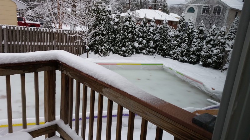
Sun coming out, beautiful winter scene on the first day of Spring.
Last edited by docstox12 on Sat Mar 21, 2015 10:21 am; edited 1 time in total

docstox12- Wx Statistician Guru
- Posts : 8505
Reputation : 222
Join date : 2013-01-07
Age : 73
Location : Monroe NY
Re: 3/20 Spring Snowstorm Observations / Final Call Snow Map
![]() by oldtimer Sat Mar 21, 2015 9:39 am
by oldtimer Sat Mar 21, 2015 9:39 am
oldtimer- Senior Enthusiast

- Posts : 1103
Reputation : 14
Join date : 2013-01-16
Age : 78
Location : Port Jefferson Station Suffolk County
Re: 3/20 Spring Snowstorm Observations / Final Call Snow Map
![]() by CPcantmeasuresnow Sat Mar 21, 2015 10:01 am
by CPcantmeasuresnow Sat Mar 21, 2015 10:01 am
docstox12 wrote:Not me, I like it up here.70 inches in a season that did not feature any storm over one foot.My 25 years in Mahwah only had one season over 70 inches, 79 in '95-'96.Remember the November storm CP, we got 9 inches here while areas S and E got very little.The pendulum will swing back someday to favor areas N and W and when it does, we are going to get blasted up here.Luckily we are still able to catch some of the storms here that have been going S and E of us.The poor Snow Weenies up in Roscoe, 50 or 60 miles N and W of us have really been scrooed over.
Sun coming out, beautiful winter scene on the first day of Spring.
Even winters we get so called screwed like this one, like you say 70 inches is still a real nice winter. Of course the other big benefit is the cold which does keep our snowpack around a lot longer. Very true about 60 miles NW of us that has been the true screw zone this winter.
Actually the true screw zone may be Alex up in Vermont. Boston has 108 inches and northern Vermont has 60-80 inches so far this season. The weather world has been turned upside down.
CPcantmeasuresnow- Wx Statistician Guru
- Posts : 7274
Reputation : 230
Join date : 2013-01-07
Age : 103
Location : Eastern Orange County, NY
Re: 3/20 Spring Snowstorm Observations / Final Call Snow Map
![]() by sroc4 Sat Mar 21, 2015 10:18 am
by sroc4 Sat Mar 21, 2015 10:18 am

_________________
"In weather and in life, there's no winning and losing; there's only winning and learning."
WINTER 2012/2013 TOTALS 43.65"WINTER 2017/2018 TOTALS 62.85" WINTER 2022/2023 TOTALS 4.9"
WINTER 2013/2014 TOTALS 64.85"WINTER 2018/2019 TOTALS 14.25" WINTER 2023/2024 TOTALS 13.1"
WINTER 2014/2015 TOTALS 71.20"WINTER 2019/2020 TOTALS 6.35"
WINTER 2015/2016 TOTALS 35.00"WINTER 2020/2021 TOTALS 37.75"
WINTER 2016/2017 TOTALS 42.25"WINTER 2021/2022 TOTALS 31.65"
sroc4- Admin
- Posts : 8331
Reputation : 301
Join date : 2013-01-07
Location : Wading River, LI
Re: 3/20 Spring Snowstorm Observations / Final Call Snow Map
![]() by Guest Sat Mar 21, 2015 10:27 am
by Guest Sat Mar 21, 2015 10:27 am
Math23x7 wrote:I just made a snowfall measurement of 4" putting me over 50" on the year!
Hey Math there is no way. Absolutely no way you are at just 50" for the season. You are only 13 miles due west of me and I'm at 70.5" and I shovel for my parents who live in your neighborhood and the only time I received significantly more than them was Juno, and even that was only a 5" difference. Uou have to be at 60"+

MAYBE MATH IS SECRETELY THE CENTRAL PARK ZOOKEPER!!!
Guest- Guest
Re: 3/20 Spring Snowstorm Observations / Final Call Snow Map
![]() by RJB8525 Sat Mar 21, 2015 10:35 am
by RJB8525 Sat Mar 21, 2015 10:35 am

RJB8525- Senior Enthusiast
- Posts : 1994
Reputation : 28
Join date : 2013-02-06
Age : 38
Location : Hackettstown, NJ
Re: 3/20 Spring Snowstorm Observations / Final Call Snow Map
![]() by docstox12 Sat Mar 21, 2015 10:42 am
by docstox12 Sat Mar 21, 2015 10:42 am
docstox12- Wx Statistician Guru
- Posts : 8505
Reputation : 222
Join date : 2013-01-07
Age : 73
Location : Monroe NY
Re: 3/20 Spring Snowstorm Observations / Final Call Snow Map
![]() by Math23x7 Sat Mar 21, 2015 11:08 am
by Math23x7 Sat Mar 21, 2015 11:08 am
syosnow94 wrote:Math23x7 wrote:I just made a snowfall measurement of 4" putting me over 50" on the year!
Hey Math there is no way. Absolutely no way you are at just 50" for the season. You are only 13 miles due west of me and I'm at 70.5" and I shovel for my parents who live in your neighborhood and the only time I received significantly more than them was Juno, and even that was only a 5" difference. Uou have to be at 60"+
MAYBE MATH IS SECRETELY THE CENTRAL PARK ZOOKEPER!!!
James, you mentioned at the get together last January how you would be frustrated when it was raining where you were growing up and just a few miles north, it would be snowing. It happens quite a lot here. Whenever there is a snowstorm with mixing issues, Bellerose usually changes over to ice and rain sooner than both Central Park and Syosset because it is further south than those two. Also keep in mind that along the Grand Central Parkway (becomes the Northern State Parkway on Long Island) in Glen Oaks, there is a big hill. Now, the difference in elevation from just south of the GCP and the top of the hill is over 100 feet!. And then once you keep going north, there is a rapid downhill trend by the time you get to the L.I.E.. It keeps going down rapidly beyond that. This hill serves as a barrier for storms with mixed bags. Also, what tends to happen many times is that the further east a storm goes, the stronger it gets, which is why eastern Long Island and New England have had epic amounts of snow compared to NYC. Also, last year, I probably had one of the lowest snow totals out of anyone on this forum. I had 48.7" while CPK had 57.4" and many surrounding areas had 60-70"+. In fact, Upton has two zones in Queens: Northern Queens and Southern Queens. Draw a line from east to west going from the GCP at the Queens/Nassau County border to where the Jackie Robinson Parkway (formerly the Interborough Parkway) begins. Continue the line along the JRP until it goes into Brooklyn. That's the dividing line. So I am in Southern Queens, meaning my snow totals will be much closer to JFK airport's snow totals. If you look below, you will see my snow totals from this season.
Math23x7- Wx Statistician Guru
- Posts : 2379
Reputation : 68
Join date : 2013-01-08
Re: 3/20 Spring Snowstorm Observations / Final Call Snow Map
![]() by Guest Sat Mar 21, 2015 11:12 am
by Guest Sat Mar 21, 2015 11:12 am
Math23x7 wrote:syosnow94 wrote:Math23x7 wrote:I just made a snowfall measurement of 4" putting me over 50" on the year!
Hey Math there is no way. Absolutely no way you are at just 50" for the season. You are only 13 miles due west of me and I'm at 70.5" and I shovel for my parents who live in your neighborhood and the only time I received significantly more than them was Juno, and even that was only a 5" difference. Uou have to be at 60"+
MAYBE MATH IS SECRETELY THE CENTRAL PARK ZOOKEPER!!!
James, you mentioned at the get together last January how you would be frustrated when it was raining where you were growing up and just a few miles north, it would be snowing. It happens quite a lot here. Whenever there is a snowstorm with mixing issues, Bellerose usually changes over to ice and rain sooner than both Central Park and Syosset because it is further south than those two. Also keep in mind that along the Grand Central Parkway (becomes the Northern State Parkway on Long Island) in Glen Oaks, there is a big hill. Now, the difference in elevation from just south of the GCP and the top of the hill is over 100 feet!. And then once you keep going north, there is a rapid downhill trend by the time you get to the L.I.E.. It keeps going down rapidly beyond that. This hill serves as a barrier for storms with mixed bags. Also, what tends to happen many times is that the further east a storm goes, the stronger it gets, which is why eastern Long Island and New England have had epic amounts of snow compared to NYC. Also, last year, I probably had one of the lowest snow totals out of anyone on this forum. I had 48.7" while CPK had 57.4" and many surrounding areas had 60-70"+. In fact, Upton has two zones in Queens: Northern Queens and Southern Queens. Draw a line from east to west going from the GCP at the Queens/Nassau County border to where the Jackie Robinson Parkway (formerly the Interborough Parkway) begins. Continue the line along the JRP until it goes into Brooklyn. That's the dividing line. So I am in Southern Queens, meaning my snow totals will be much closer to JFK airport's snow totals. If you look below, you will see my snow totals from this season.
I know that hill. Commonwealth Blvd!! I trust your measurements I was just playing around with you. My parents house is 1/4 due east of thet hill by the way.
I STILL THINK YOU MAY BE THE CP ZOOKEPER THOUGH!! Or at least related.

Guest- Guest
Re: 3/20 Spring Snowstorm Observations / Final Call Snow Map
![]() by Dtone Sat Mar 21, 2015 12:00 pm
by Dtone Sat Mar 21, 2015 12:00 pm
Math23x7 wrote:syosnow94 wrote:Math23x7 wrote:I just made a snowfall measurement of 4" putting me over 50" on the year!
Hey Math there is no way. Absolutely no way you are at just 50" for the season. You are only 13 miles due west of me and I'm at 70.5" and I shovel for my parents who live in your neighborhood and the only time I received significantly more than them was Juno, and even that was only a 5" difference. Uou have to be at 60"+
MAYBE MATH IS SECRETELY THE CENTRAL PARK ZOOKEPER!!!
James, you mentioned at the get together last January how you would be frustrated when it was raining where you were growing up and just a few miles north, it would be snowing. It happens quite a lot here. Whenever there is a snowstorm with mixing issues, Bellerose usually changes over to ice and rain sooner than both Central Park and Syosset because it is further south than those two. Also keep in mind that along the Grand Central Parkway (becomes the Northern State Parkway on Long Island) in Glen Oaks, there is a big hill. Now, the difference in elevation from just south of the GCP and the top of the hill is over 100 feet!. And then once you keep going north, there is a rapid downhill trend by the time you get to the L.I.E.. It keeps going down rapidly beyond that. This hill serves as a barrier for storms with mixed bags. Also, what tends to happen many times is that the further east a storm goes, the stronger it gets, which is why eastern Long Island and New England have had epic amounts of snow compared to NYC. Also, last year, I probably had one of the lowest snow totals out of anyone on this forum. I had 48.7" while CPK had 57.4" and many surrounding areas had 60-70"+. In fact, Upton has two zones in Queens: Northern Queens and Southern Queens. Draw a line from east to west going from the GCP at the Queens/Nassau County border to where the Jackie Robinson Parkway (formerly the Interborough Parkway) begins. Continue the line along the JRP until it goes into Brooklyn. That's the dividing line. So I am in Southern Queens, meaning my snow totals will be much closer to JFK airport's snow totals. If you look below, you will see my snow totals from this season.
Any map with topography shows that hill running through the middle of Qns. I've also noticed southerly sea breezes in spring and summer get up to that point easily, if it gets past that point it probably will influence the whole region instead of a localized area.
In Feb I had to go to JFK area a few times and I noticed the significantly smaller snow pack south of about the Grand Central..esp south of say Jamaica LIRR station. I was like wow there is patches of bare ground visible here. Parking in SE Queens areas was a breeze compared to snow clogged Bx streets
Dtone- Wx Statistician Guru
- Posts : 1738
Reputation : 9
Join date : 2013-08-26
Location : Bronx, NY
Re: 3/20 Spring Snowstorm Observations / Final Call Snow Map
![]() by algae888 Sat Mar 21, 2015 2:44 pm
by algae888 Sat Mar 21, 2015 2:44 pm
100 percent of the snow on paved surfaces is gone and about 60 percent on the grass. melted really quickRJB8525 wrote:and she goes, got 5" 90% is melted away already 36* strong sun

algae888- Advanced Forecaster

- Posts : 5311
Reputation : 46
Join date : 2013-02-05
Age : 61
Location : mt. vernon, new york
Re: 3/20 Spring Snowstorm Observations / Final Call Snow Map
![]() by Dunnzoo Sat Mar 21, 2015 2:53 pm
by Dunnzoo Sat Mar 21, 2015 2:53 pm
_________________
Janet
Snowfall winter of 2023-2024 17.5"
Snowfall winter of 2022-2023 6.0"
Snowfall winter of 2021-2022 17.6" 1" sleet 2/25/22
Snowfall winter of 2020-2021 51.1"
Snowfall winter of 2019-2020 8.5"
Snowfall winter of 2018-2019 25.1"
Snowfall winter of 2017-2018 51.9"
Snowfall winter of 2016-2017 45.6"
Snowfall winter of 2015-2016 29.5"
Snowfall winter of 2014-2015 50.55"
Snowfall winter of 2013-2014 66.5"

Dunnzoo- Senior Enthusiast - Mod
- Posts : 4891
Reputation : 68
Join date : 2013-01-11
Age : 62
Location : Westwood, NJ
Re: 3/20 Spring Snowstorm Observations / Final Call Snow Map
![]() by algae888 Sat Mar 21, 2015 3:43 pm
by algae888 Sat Mar 21, 2015 3:43 pm
algae888- Advanced Forecaster
- Posts : 5311
Reputation : 46
Join date : 2013-02-05
Age : 61
Location : mt. vernon, new york
Re: 3/20 Spring Snowstorm Observations / Final Call Snow Map
![]() by NjWeatherGuy Sat Mar 21, 2015 3:45 pm
by NjWeatherGuy Sat Mar 21, 2015 3:45 pm
algae888 wrote:so the euro and the GFS basically nailed the storm as they had the 4 plus inch amounts into Connecticut whereas the nam, rgem and CMC had the heavier precipitation to the south. frank next winter we should have a model verification score with the operationals starting around day 7. I know scott started one for the h5 pattern earlier this winter. I think it could be a good tool helping us to forecast storms next year. it will help us to see which model handles different patterns the best. I think the biggest challenge with doing this is to be consistent as it will take a lot of time and effort. we will probably need a few people stay on top of it. what do you think?
Heaviest snow axis was essentially to the south where the EURO/GFS showed mixing and less amounts so Id say the RGEM/NAM in mid range did well.

NjWeatherGuy- Advanced Forecaster
- Posts : 4100
Reputation : 28
Join date : 2013-01-06
Location : Belle Mead, NJ
Re: 3/20 Spring Snowstorm Observations / Final Call Snow Map
![]() by algae888 Sat Mar 21, 2015 3:50 pm
by algae888 Sat Mar 21, 2015 3:50 pm
algae888 wrote:so the euro and the GFS basically nailed the storm as they had the 4 plus inch amounts into Connecticut whereas the nam, rgem and CMC had the heavier precipitation to the south. frank next winter we should have a model verification score with the operationals starting around day 7. I know scott started one for the h5 pattern earlier this winter. I think it could be a good tool helping us to forecast storms next year. it will help us to see which model handles different patterns the best. I think the biggest challenge with doing this is to be consistent as it will take a lot of time and effort. we will probably need a few people stay on top of it. what do you think?
Heaviest snow axis was essentially to the south where the EURO/GFS showed mixing and less amounts so Id say the RGEM/NAM in mid range did well.[/quote]
I disagree the euro and gfs had four to six inch amounts from Philadelphia up through Connecticut. Fairfield County had the heaviest snow totals in Uptons area. Nam rgem we're showing 2 inch amounts for them. Check National Weather Service storm totals. some places in Fairfield County received 8 inches of snow
algae888- Advanced Forecaster
- Posts : 5311
Reputation : 46
Join date : 2013-02-05
Age : 61
Location : mt. vernon, new york
Re: 3/20 Spring Snowstorm Observations / Final Call Snow Map
![]() by algae888 Sat Mar 21, 2015 3:55 pm
by algae888 Sat Mar 21, 2015 3:55 pm
algae888- Advanced Forecaster
- Posts : 5311
Reputation : 46
Join date : 2013-02-05
Age : 61
Location : mt. vernon, new york
Page 18 of 19 • 1 ... 10 ... 17, 18, 19 ![]()
|
|
|