
 Search
3/20 Spring Snowstorm Observations / Final Call Snow Map
Page 3 of 19 •  1, 2, 3, 4 ... 11 ... 19
 ![]()
Re: 3/20 Spring Snowstorm Observations / Final Call Snow Map
![]() by Guest Fri Mar 20, 2015 9:28 am
by Guest Fri Mar 20, 2015 9:28 am
Guest- Guest
Re: 3/20 Spring Snowstorm Observations / Final Call Snow Map
![]() by Frank_Wx Fri Mar 20, 2015 9:31 am
by Frank_Wx Fri Mar 20, 2015 9:31 am
Frank_Wx- Godzilla Seeker

- Posts : 21305
Join date : 2013-01-05 -

Re: 3/20 Spring Snowstorm Observations / Final Call Snow Map
![]() by Quietace Fri Mar 20, 2015 9:34 am
by Quietace Fri Mar 20, 2015 9:34 am
Ouch...haha, fair statement though..syosnow94 wrote:2 things.
1. I never said "bust" I said the radar doesn't look good so I'm not confident about accumulating snows right now.
2. Quietace has to be the most contrarian/negative person on this board when it comes to a snow forecast
Anyway 37 and light snow

Quietace- Meteorologist - Mod

- Posts : 3687
Reputation : 33
Join date : 2013-01-07
Age : 27
Location : Point Pleasant, NJ
Re: 3/20 Spring Snowstorm Observations / Final Call Snow Map
![]() by Frank_Wx Fri Mar 20, 2015 9:51 am
by Frank_Wx Fri Mar 20, 2015 9:51 am
_________________
_______________________________________________________________________________________________________
CLICK HERE to view NJ Strong Snowstorm Classifications

Frank_Wx- Godzilla Seeker
- Posts : 21305
Reputation : 328
Join date : 2013-01-05
Age : 31
Location : Jersey City, NJ -
Re: 3/20 Spring Snowstorm Observations / Final Call Snow Map
![]() by docstox12 Fri Mar 20, 2015 9:53 am
by docstox12 Fri Mar 20, 2015 9:53 am

docstox12- Wx Statistician Guru

- Posts : 8502
Reputation : 222
Join date : 2013-01-07
Age : 73
Location : Monroe NY
Re: 3/20 Spring Snowstorm Observations / Final Call Snow Map
![]() by Frank_Wx Fri Mar 20, 2015 9:55 am
by Frank_Wx Fri Mar 20, 2015 9:55 am

_________________
_______________________________________________________________________________________________________
CLICK HERE to view NJ Strong Snowstorm Classifications
Frank_Wx- Godzilla Seeker
- Posts : 21305
Reputation : 328
Join date : 2013-01-05
Age : 31
Location : Jersey City, NJ -
Re: 3/20 Spring Snowstorm Observations / Final Call Snow Map
![]() by Frank_Wx Fri Mar 20, 2015 9:56 am
by Frank_Wx Fri Mar 20, 2015 9:56 am
_________________
_______________________________________________________________________________________________________
CLICK HERE to view NJ Strong Snowstorm Classifications
Frank_Wx- Godzilla Seeker
- Posts : 21305
Reputation : 328
Join date : 2013-01-05
Age : 31
Location : Jersey City, NJ -
Re: 3/20 Spring Snowstorm Observations / Final Call Snow Map
![]() by Frank_Wx Fri Mar 20, 2015 9:58 am
by Frank_Wx Fri Mar 20, 2015 9:58 am

_________________
_______________________________________________________________________________________________________
CLICK HERE to view NJ Strong Snowstorm Classifications
Frank_Wx- Godzilla Seeker
- Posts : 21305
Reputation : 328
Join date : 2013-01-05
Age : 31
Location : Jersey City, NJ -
Re: 3/20 Spring Snowstorm Observations / Final Call Snow Map
![]() by Frank_Wx Fri Mar 20, 2015 9:59 am
by Frank_Wx Fri Mar 20, 2015 9:59 am

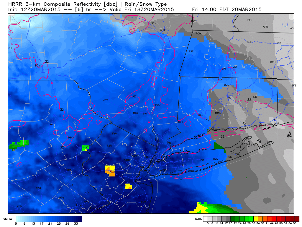
1pm H7 VV's

1-5pm seems like the heaviest time frame for heavy snow
_________________
_______________________________________________________________________________________________________
CLICK HERE to view NJ Strong Snowstorm Classifications
Frank_Wx- Godzilla Seeker
- Posts : 21305
Reputation : 328
Join date : 2013-01-05
Age : 31
Location : Jersey City, NJ -
Re: 3/20 Spring Snowstorm Observations / Final Call Snow Map
![]() by amugs Fri Mar 20, 2015 10:01 am
by amugs Fri Mar 20, 2015 10:01 am
HRRR and SREFS showing a jog north with precip - looks like March 5th storm to me minus the heavy dry air on the north of this.
Once we get the coastal going things swill be interesting
_________________
Mugs
AKA:King: Snow Weenie
Self Proclaimed
WINTER 2014-15 : 55.12" +.02 for 6 coatings (avg. 35")
WINTER 2015-16 Total - 29.8" (Avg 35")
WINTER 2016-17 : 39.5" so far

amugs- Advanced Forecaster - Mod

- Posts : 15093
Reputation : 213
Join date : 2013-01-07
Age : 54
Location : Hillsdale,NJ
Re: 3/20 Spring Snowstorm Observations / Final Call Snow Map
![]() by sroc4 Fri Mar 20, 2015 10:03 am
by sroc4 Fri Mar 20, 2015 10:03 am
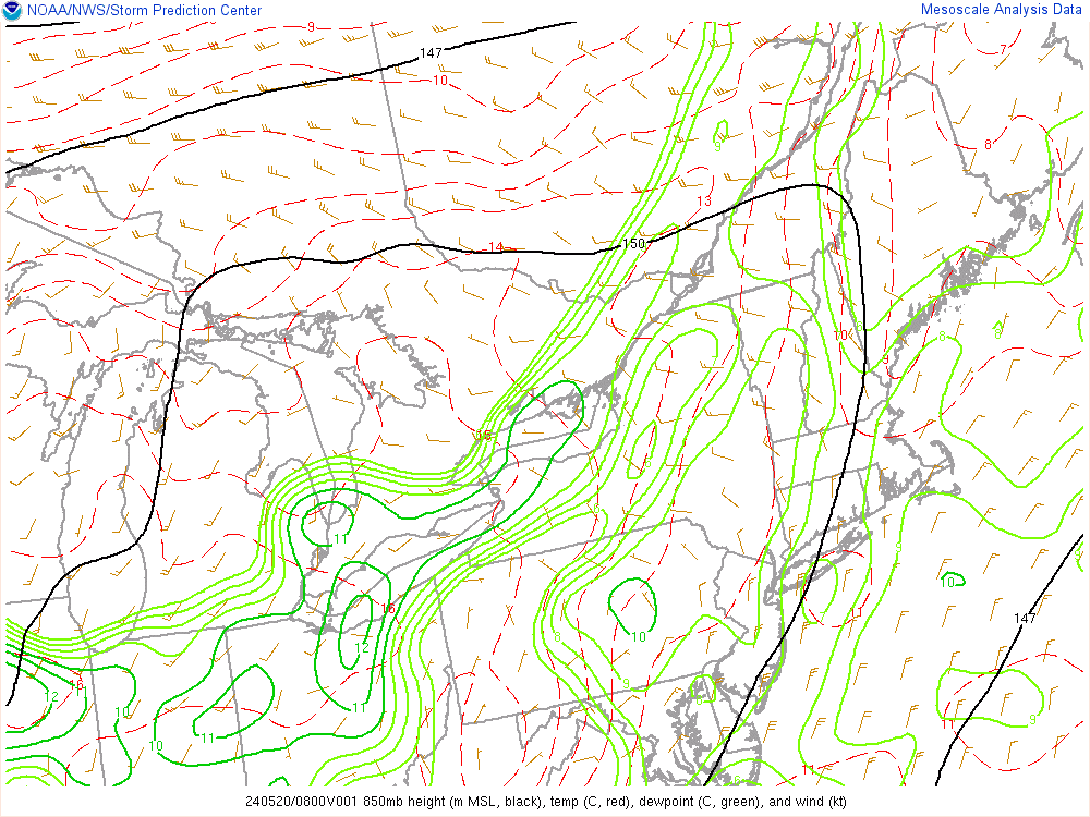
925mb
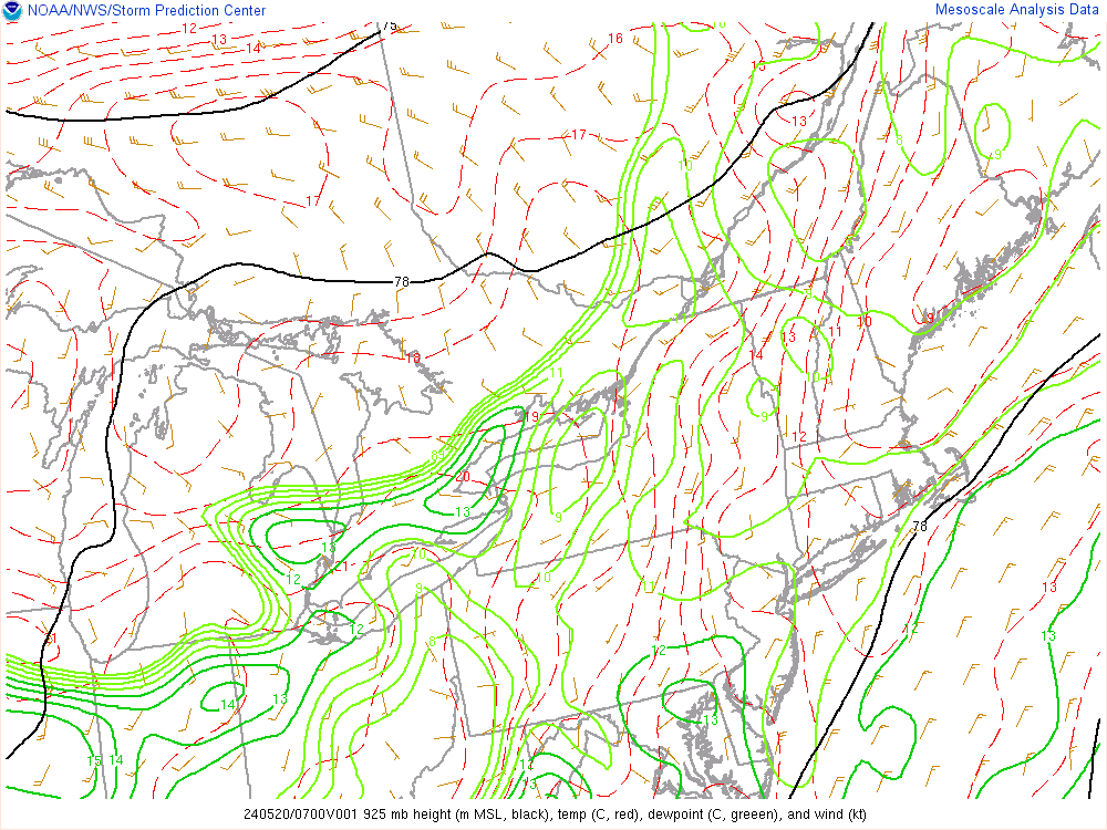
850mb
_________________
"In weather and in life, there's no winning and losing; there's only winning and learning."
WINTER 2012/2013 TOTALS 43.65"WINTER 2017/2018 TOTALS 62.85" WINTER 2022/2023 TOTALS 4.9"
WINTER 2013/2014 TOTALS 64.85"WINTER 2018/2019 TOTALS 14.25" WINTER 2023/2024 TOTALS 13.1"
WINTER 2014/2015 TOTALS 71.20"WINTER 2019/2020 TOTALS 6.35"
WINTER 2015/2016 TOTALS 35.00"WINTER 2020/2021 TOTALS 37.75"
WINTER 2016/2017 TOTALS 42.25"WINTER 2021/2022 TOTALS 31.65"

sroc4- Admin
- Posts : 8331
Reputation : 301
Join date : 2013-01-07
Location : Wading River, LI
Re: 3/20 Spring Snowstorm Observations / Final Call Snow Map
![]() by Guest Fri Mar 20, 2015 10:13 am
by Guest Fri Mar 20, 2015 10:13 am
Guest- Guest
Re: 3/20 Spring Snowstorm Observations / Final Call Snow Map
![]() by Frank_Wx Fri Mar 20, 2015 10:14 am
by Frank_Wx Fri Mar 20, 2015 10:14 am
syosnow94 wrote:HAHAHAHA it worked!!!
_________________
_______________________________________________________________________________________________________
CLICK HERE to view NJ Strong Snowstorm Classifications
Frank_Wx- Godzilla Seeker
- Posts : 21305
Reputation : 328
Join date : 2013-01-05
Age : 31
Location : Jersey City, NJ -
Re: 3/20 Spring Snowstorm Observations / Final Call Snow Map
![]() by Frank_Wx Fri Mar 20, 2015 10:16 am
by Frank_Wx Fri Mar 20, 2015 10:16 am
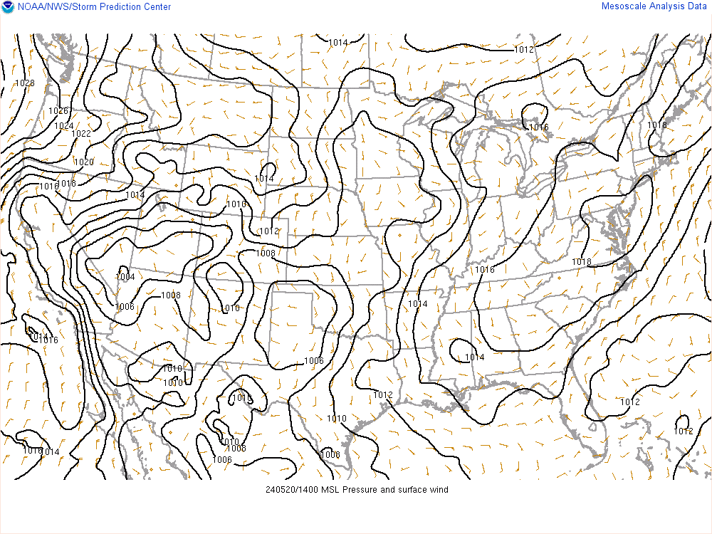
sroc4 wrote:Surface pressures:
925mb
850mb
Is it just me or does that coastal low look really far south?
_________________
_______________________________________________________________________________________________________
CLICK HERE to view NJ Strong Snowstorm Classifications
Frank_Wx- Godzilla Seeker
- Posts : 21305
Reputation : 328
Join date : 2013-01-05
Age : 31
Location : Jersey City, NJ -
Re: 3/20 Spring Snowstorm Observations / Final Call Snow Map
![]() by Frank_Wx Fri Mar 20, 2015 10:20 am
by Frank_Wx Fri Mar 20, 2015 10:20 am
Lovely.
_________________
_______________________________________________________________________________________________________
CLICK HERE to view NJ Strong Snowstorm Classifications
Frank_Wx- Godzilla Seeker
- Posts : 21305
Reputation : 328
Join date : 2013-01-05
Age : 31
Location : Jersey City, NJ -
Re: 3/20 Spring Snowstorm Observations / Final Call Snow Map
![]() by Frank_Wx Fri Mar 20, 2015 10:21 am
by Frank_Wx Fri Mar 20, 2015 10:21 am
Frank_Wx wrote:sroc4 wrote:Surface pressures:
925mb
850mb
Is it just me or does that coastal low look really far south?
Goes to show how you can get a storm with potent upper air energy, favorably positioned jet streaks and being near the baroclinic zone
_________________
_______________________________________________________________________________________________________
CLICK HERE to view NJ Strong Snowstorm Classifications
Frank_Wx- Godzilla Seeker
- Posts : 21305
Reputation : 328
Join date : 2013-01-05
Age : 31
Location : Jersey City, NJ -
Re: 3/20 Spring Snowstorm Observations / Final Call Snow Map
![]() by algae888 Fri Mar 20, 2015 10:25 am
by algae888 Fri Mar 20, 2015 10:25 am

algae888- Advanced Forecaster

- Posts : 5311
Reputation : 46
Join date : 2013-02-05
Age : 61
Location : mt. vernon, new york
Re: 3/20 Spring Snowstorm Observations / Final Call Snow Map
![]() by Frank_Wx Fri Mar 20, 2015 10:27 am
by Frank_Wx Fri Mar 20, 2015 10:27 am
Today? Not happening. It's snowing.
_________________
_______________________________________________________________________________________________________
CLICK HERE to view NJ Strong Snowstorm Classifications
Frank_Wx- Godzilla Seeker
- Posts : 21305
Reputation : 328
Join date : 2013-01-05
Age : 31
Location : Jersey City, NJ -
Re: 3/20 Spring Snowstorm Observations / Final Call Snow Map
![]() by Frank_Wx Fri Mar 20, 2015 10:27 am
by Frank_Wx Fri Mar 20, 2015 10:27 am

_________________
_______________________________________________________________________________________________________
CLICK HERE to view NJ Strong Snowstorm Classifications
Frank_Wx- Godzilla Seeker
- Posts : 21305
Reputation : 328
Join date : 2013-01-05
Age : 31
Location : Jersey City, NJ -
Re: 3/20 Spring Snowstorm Observations / Final Call Snow Map
![]() by Frank_Wx Fri Mar 20, 2015 10:28 am
by Frank_Wx Fri Mar 20, 2015 10:28 am

_________________
_______________________________________________________________________________________________________
CLICK HERE to view NJ Strong Snowstorm Classifications
Frank_Wx- Godzilla Seeker
- Posts : 21305
Reputation : 328
Join date : 2013-01-05
Age : 31
Location : Jersey City, NJ -
Re: 3/20 Spring Snowstorm Observations / Final Call Snow Map
![]() by Grselig Fri Mar 20, 2015 10:28 am
by Grselig Fri Mar 20, 2015 10:28 am
syosnow94 wrote:HAHAHAHA it worked!!!
genius!

Grselig- Senior Enthusiast

- Posts : 1408
Reputation : 140
Join date : 2013-03-04
Age : 54
Location : Wayne NJ
Re: 3/20 Spring Snowstorm Observations / Final Call Snow Map
![]() by Frank_Wx Fri Mar 20, 2015 10:39 am
by Frank_Wx Fri Mar 20, 2015 10:39 am

_________________
_______________________________________________________________________________________________________
CLICK HERE to view NJ Strong Snowstorm Classifications
Frank_Wx- Godzilla Seeker
- Posts : 21305
Reputation : 328
Join date : 2013-01-05
Age : 31
Location : Jersey City, NJ -
Re: 3/20 Spring Snowstorm Observations / Final Call Snow Map
![]() by CPcantmeasuresnow Fri Mar 20, 2015 10:44 am
by CPcantmeasuresnow Fri Mar 20, 2015 10:44 am
I probably just doomed the HV with the KOD.
28.8 waiting for a flake.
Last edited by CPcantmeasuresnow on Fri Mar 20, 2015 10:45 am; edited 1 time in total

CPcantmeasuresnow- Wx Statistician Guru
- Posts : 7274
Reputation : 230
Join date : 2013-01-07
Age : 103
Location : Eastern Orange County, NY
Re: 3/20 Spring Snowstorm Observations / Final Call Snow Map
![]() by sroc4 Fri Mar 20, 2015 10:45 am
by sroc4 Fri Mar 20, 2015 10:45 am
Frank_Wx wrote:Frank_Wx wrote:sroc4 wrote:Surface pressures:
925mb
850mb
Is it just me or does that coastal low look really far south?
Goes to show how you can get a storm with potent upper air energy, favorably positioned jet streaks and being near the baroclinic zone
Exactly Frank. Our last 3 events showed us that beautifully. Ive learned alot studying these set ups. Youll notice there are two areas of LP currently on the meso surface pressure map.
[img]
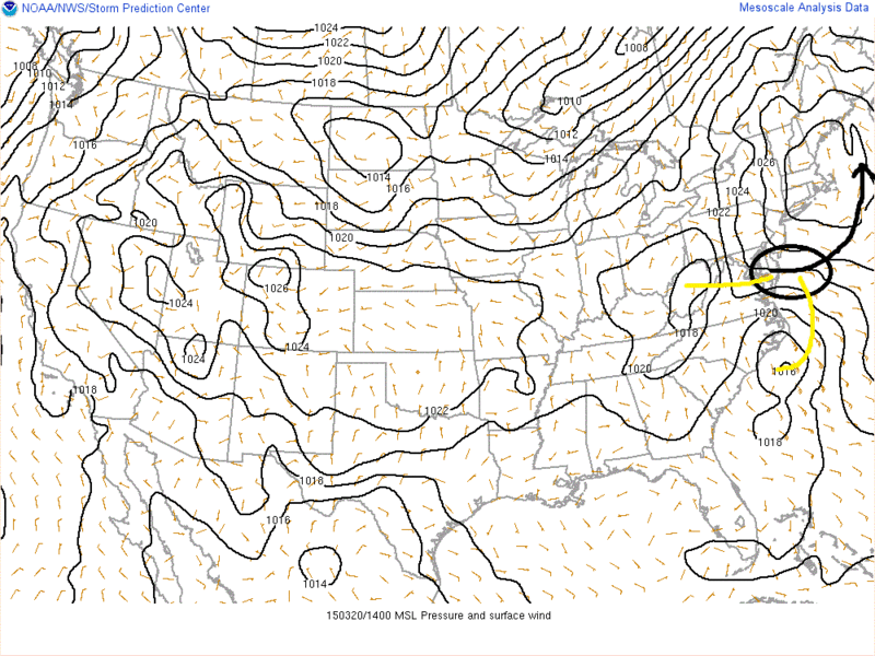 [/img]
I think the one over WV ultimately wins and takes over and a single LP forms in the black circle.
BTW looks like 850 is trying to close off.
_________________
"In weather and in life, there's no winning and losing; there's only winning and learning."
WINTER 2012/2013 TOTALS 43.65"WINTER 2017/2018 TOTALS 62.85" WINTER 2022/2023 TOTALS 4.9"
WINTER 2013/2014 TOTALS 64.85"WINTER 2018/2019 TOTALS 14.25" WINTER 2023/2024 TOTALS 13.1"
WINTER 2014/2015 TOTALS 71.20"WINTER 2019/2020 TOTALS 6.35"
WINTER 2015/2016 TOTALS 35.00"WINTER 2020/2021 TOTALS 37.75"
WINTER 2016/2017 TOTALS 42.25"WINTER 2021/2022 TOTALS 31.65"
sroc4- Admin
- Posts : 8331
Reputation : 301
Join date : 2013-01-07
Location : Wading River, LI
Re: 3/20 Spring Snowstorm Observations / Final Call Snow Map
![]() by docstox12 Fri Mar 20, 2015 11:03 am
by docstox12 Fri Mar 20, 2015 11:03 am
CPcantmeasuresnow wrote:I don't want to let my guard down but I'm starting to believe we even have a chance here up north for a decent snow. Models now ticking a bit north rather than south trend and as Mugs said earlier we don't have that heavy dense cold dry air to our north like we did on the March 5th storm.
I probably just doomed the HV with the KOD.
28.8 waiting for a flake.
Yep, CP, even though it is futile, I still liked the look of that radar with lots of snow to our N and W.
We've got the cold, just need the snow now.Almost here.
docstox12- Wx Statistician Guru
- Posts : 8502
Reputation : 222
Join date : 2013-01-07
Age : 73
Location : Monroe NY
Re: 3/20 Spring Snowstorm Observations / Final Call Snow Map
![]() by Taffy Fri Mar 20, 2015 11:08 am
by Taffy Fri Mar 20, 2015 11:08 am

Taffy- Pro Enthusiast

- Posts : 530
Reputation : 19
Join date : 2013-10-06
Location : Hopkinton, MA
Page 3 of 19 • 1, 2, 3, 4 ... 11 ... 19 ![]()
|
|
|