
 Search
Long Range Thread 8.0
+30
Grselig
devsman
chief7
oldtimer
Noreaster
Quietace
mako460
jimv45
rb924119
sroc4
HectorO
snow247
essexcountypete
chinkaps
billg315
Snow88
dkodgis
docstox12
WOLVES1
nutleyblizzard
CPcantmeasuresnow
algae888
skinsfan1177
Dunnzoo
weatherwatchermom
Math23x7
jmanley32
amugs
Dtone
Frank_Wx
34 posters
Page 40 of 40
Page 40 of 40 •  1 ... 21 ... 38, 39, 40
Re: Long Range Thread 8.0
![]() by nutleyblizzard Mon Nov 16, 2015 10:35 am
by nutleyblizzard Mon Nov 16, 2015 10:35 am
Here are this week's ENSO readings:
Regions 1@2: 2.0
Region 3: 3.0
Region 3.4: 3.0
Region 4: 1.7
New weekly record for region 3.4! Central basin has now reached super status levels and regions 1@2 continue to cool!
nutleyblizzard- Senior Enthusiast

- Posts : 1952
Join date : 2014-01-30
Re: Long Range Thread 8.0
![]() by Frank_Wx Mon Nov 16, 2015 11:20 am
by Frank_Wx Mon Nov 16, 2015 11:20 am
Man this El Nino event is impressive. Looking over current observations, it appears 300 mb easterly winds are weakening and 850 mb westerly winds are also weakening. Nothing is set in stone yet, but this could be an indication El Nino peaked or is close to peaking. That would be welcoming news for winter prospects.
Frank_Wx- Godzilla Seeker

- Posts : 21305
Join date : 2013-01-05 -

Re: Long Range Thread 8.0
![]() by amugs Mon Nov 16, 2015 11:38 am
by amugs Mon Nov 16, 2015 11:38 am
The pattern seems to be going through this state of flux as we enter into meteorological winter. Th eimportant aspect that I like seeing is that our tropical convection or "forcing" is setting up and doing some business out at the dateline. How so you ask? Well look at teh latest OLR maps )outgoing Longwave Radiation) - measure teh convection or t-storms activity. If yuo look atthis OLR map it shows teh purple areas over teh equator and at the dateline - BINGO!! This si key becasue it will have a downstream affect. I have been harping on teh trop "forcing" setting up at the dateline area all summer and fall (adament as SROC put it). Look at the map:
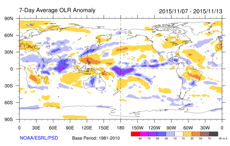
Now why again is this important to see? This means that as we move forward this area will have a great influence on our pattern - setting up trough positive feedback in the atmosphere a -EPO by releasing this latent heat from these tremendously/historic warm anomalous waters in this area Region 3.4 and 4. Number come out this week or even today I believe. It will help a NEG EPO form over the waters South of the Aleutian Islands - this will in turn help open up the cold air that is over the border in Russia/Siberia and give us a much needed cross polar flow. This is going to be needed to help beat down the SE ridge that will try to invade us this winter.
So from the dateline forcing we will get positive feedback that will give us a NEG EPO and will then help raise the heights along the west coast giving us a POS PNA that will in turn help produce a trough fro the east coast. Another aspect in our pattern now is this tremendously cold and condensed polar vortex or +AO. This is fine by and let it build I say cause when the dam breaks MOMMA MIA - all that cold air has to filter down, we just need the dam to break and this will come as we progress towards winter.
The NAO index that Isotherm so well explained is going to be negative in the means meaning for most of the winter and this is something I wrote about in my comparison to 2009-10 that we would see this neg state of the NAO. Only difference is that was a mod nino and this one is strong BUT the NEG NAO will be very helpful as move into winter.
Great sign and we need this frocing to set up shop here and cause the other dynamics to take place in our atmosphere - the Quadruplets -EPO/+PNA/-AO/-NAO FTW !!
_________________
Mugs
AKA:King: Snow Weenie
Self Proclaimed
WINTER 2014-15 : 55.12" +.02 for 6 coatings (avg. 35")
WINTER 2015-16 Total - 29.8" (Avg 35")
WINTER 2016-17 : 39.5" so far

amugs- Advanced Forecaster - Mod

- Posts : 15093
Reputation : 213
Join date : 2013-01-07
Age : 54
Location : Hillsdale,NJ
Re: Long Range Thread 8.0
![]() by Frank_Wx Mon Nov 16, 2015 12:07 pm
by Frank_Wx Mon Nov 16, 2015 12:07 pm
I'm not going to relax and blow a sigh of relief until Nino region 3.4 weakens. If it maintains this type of intensity we'll see more in the way of Southeast ridging. That's why I feel December will be similar to November in terms of temperatures departures. Though we should see more cold shots mixed in if the EPO stays negative, which isn't looking likely at the moment. Doesn't mean it can't return by 2nd week of Dec though.
_________________
_______________________________________________________________________________________________________
CLICK HERE to view NJ Strong Snowstorm Classifications

Frank_Wx- Godzilla Seeker
- Posts : 21305
Reputation : 328
Join date : 2013-01-05
Age : 31
Location : Jersey City, NJ -
Re: Long Range Thread 8.0
![]() by Frank_Wx Mon Nov 16, 2015 12:40 pm
by Frank_Wx Mon Nov 16, 2015 12:40 pm
The EURO and GFS suggest the EPO will enter negative territory around Thanksgiving. When we talk about a "step-down" pattern change, this is usually the first domino to see fall.

Here is today's 12z GFS run showing the large ridge over Alaska. Similar to early Met Winter last year, the EPO is negative but the PNA is also negative because of the trough's that are undercutting it. As seasonal variability becomes less of an influence, we should gradually see the PNA follow suite. I do warn the EPO may not last in the negative territory. The Pac Jet may try to knock it out, but we'll see.

Here is today's 12z GFS run showing the large ridge over Alaska. Similar to early Met Winter last year, the EPO is negative but the PNA is also negative because of the trough's that are undercutting it. As seasonal variability becomes less of an influence, we should gradually see the PNA follow suite. I do warn the EPO may not last in the negative territory. The Pac Jet may try to knock it out, but we'll see.
_________________
_______________________________________________________________________________________________________
CLICK HERE to view NJ Strong Snowstorm Classifications
Frank_Wx- Godzilla Seeker
- Posts : 21305
Reputation : 328
Join date : 2013-01-05
Age : 31
Location : Jersey City, NJ -


algae888- Advanced Forecaster

- Posts : 5311
Reputation : 46
Join date : 2013-02-05
Age : 61
Location : mt. vernon, new york
Re: Long Range Thread 8.0
![]() by UnionWX Mon Nov 16, 2015 7:04 pm
by UnionWX Mon Nov 16, 2015 7:04 pm
algae888 wrote:something to watch for the weekend...
18z GFS shows minor-decent accumulations just NE of us Sunday. Shows some flurries for us.

UnionWX- Posts : 31
Reputation : 0
Join date : 2015-10-05
Age : 38
Location : Hardyston Twp, NJ (NE Sussex)
Re: Long Range Thread 8.0
![]() by Snow88 Mon Nov 16, 2015 10:30 pm
by Snow88 Mon Nov 16, 2015 10:30 pm
Steve D was just talking on Fox 5. He said get ready for a wild winter. This winter is going to start off warm but then transition into a cold and snowy 2nd half of winter with well above average snowfall. He was also explaining how the El Nino is shifting to a more basin wide look and how region 1 and 2 are cooling and 3 and 4 are warming up. He expects interior areas to see well above normal snowfall and the coast to see the same with a lot of ice and sleet threats as well.

Snow88- Senior Enthusiast
- Posts : 2193
Reputation : 4
Join date : 2013-01-09
Age : 35
Location : Brooklyn, NY
Re: Long Range Thread 8.0
![]() by Snow88 Mon Nov 16, 2015 11:01 pm
by Snow88 Mon Nov 16, 2015 11:01 pm
Video of Steve D
http://www.fox5ny.com/news/50255617-story
http://www.fox5ny.com/news/50255617-story
Snow88- Senior Enthusiast
- Posts : 2193
Reputation : 4
Join date : 2013-01-09
Age : 35
Location : Brooklyn, NY
Re: Long Range Thread 8.0
![]() by amugs Mon Nov 16, 2015 11:14 pm
by amugs Mon Nov 16, 2015 11:14 pm
Snow88 wrote:Steve D was just talking on Fox 5. He said get ready for a wild winter. This winter is going to start off warm but then transition into a cold and snowy 2nd half of winter with well above average snowfall. He was also explaining how the El Nino is shifting to a more basin wide look and how region 1 and 2 are cooling and 3 and 4 are warming up. He expects interior areas to see well above normal snowfall and the coast to see the same with a lot of ice and sleet threats as well.
Yes, I just watched it too. Said what most of us and many logical mets are predicting. Ride the roller coaster for the next month. Recently, and posted above how the PV is very strong and when that bad boy weakens as the winter progresses the "step down" process will shift this cold air or release it down into the CONUS.
Here is snow map update:


BAZINGA BABY!!!!!!!!!!!!!!!!!!!!!!!!!!!
And the vortex is so tight if we put a piece of coal in it we would get a diamond in about 1 week!!

_________________
Mugs
AKA:King: Snow Weenie
Self Proclaimed
WINTER 2014-15 : 55.12" +.02 for 6 coatings (avg. 35")
WINTER 2015-16 Total - 29.8" (Avg 35")
WINTER 2016-17 : 39.5" so far
amugs- Advanced Forecaster - Mod
- Posts : 15093
Reputation : 213
Join date : 2013-01-07
Age : 54
Location : Hillsdale,NJ
Re: Long Range Thread 8.0
![]() by algae888 Tue Nov 17, 2015 4:18 am
by algae888 Tue Nov 17, 2015 4:18 am

interesting. can someone post a better map of euro day six.
algae888- Advanced Forecaster
- Posts : 5311
Reputation : 46
Join date : 2013-02-05
Age : 61
Location : mt. vernon, new york
Re: Long Range Thread 8.0
![]() by amugs Tue Nov 17, 2015 7:34 am
by amugs Tue Nov 17, 2015 7:34 am

_________________
Mugs
AKA:King: Snow Weenie
Self Proclaimed
WINTER 2014-15 : 55.12" +.02 for 6 coatings (avg. 35")
WINTER 2015-16 Total - 29.8" (Avg 35")
WINTER 2016-17 : 39.5" so far
amugs- Advanced Forecaster - Mod
- Posts : 15093
Reputation : 213
Join date : 2013-01-07
Age : 54
Location : Hillsdale,NJ
Re: Long Range Thread 8.0
![]() by sroc4 Tue Nov 17, 2015 8:42 am
by sroc4 Tue Nov 17, 2015 8:42 am
algae888 wrote:
interesting. can someone post a better map of euro day six.
Give me a quick minute. Ill do a nice little write up on this time frame as it the time frame I was looking at in my last two prev write ups:
_________________
"In weather and in life, there's no winning and losing; there's only winning and learning."
WINTER 2012/2013 TOTALS 43.65"WINTER 2017/2018 TOTALS 62.85" WINTER 2022/2023 TOTALS 4.9"
WINTER 2013/2014 TOTALS 64.85"WINTER 2018/2019 TOTALS 14.25" WINTER 2023/2024 TOTALS 13.1"
WINTER 2014/2015 TOTALS 71.20"WINTER 2019/2020 TOTALS 6.35"
WINTER 2015/2016 TOTALS 35.00"WINTER 2020/2021 TOTALS 37.75"
WINTER 2016/2017 TOTALS 42.25"WINTER 2021/2022 TOTALS 31.65"

sroc4- Admin
- Posts : 8331
Reputation : 301
Join date : 2013-01-07
Location : Wading River, LI
Re: Long Range Thread 8.0
![]() by Snow88 Tue Nov 17, 2015 9:27 am
by Snow88 Tue Nov 17, 2015 9:27 am
Looks like a lot of places might see their first snowflakes this coming weekend
Snow88- Senior Enthusiast
- Posts : 2193
Reputation : 4
Join date : 2013-01-09
Age : 35
Location : Brooklyn, NY
Re: Long Range Thread 8.0
![]() by sroc4 Tue Nov 17, 2015 9:48 am
by sroc4 Tue Nov 17, 2015 9:48 am
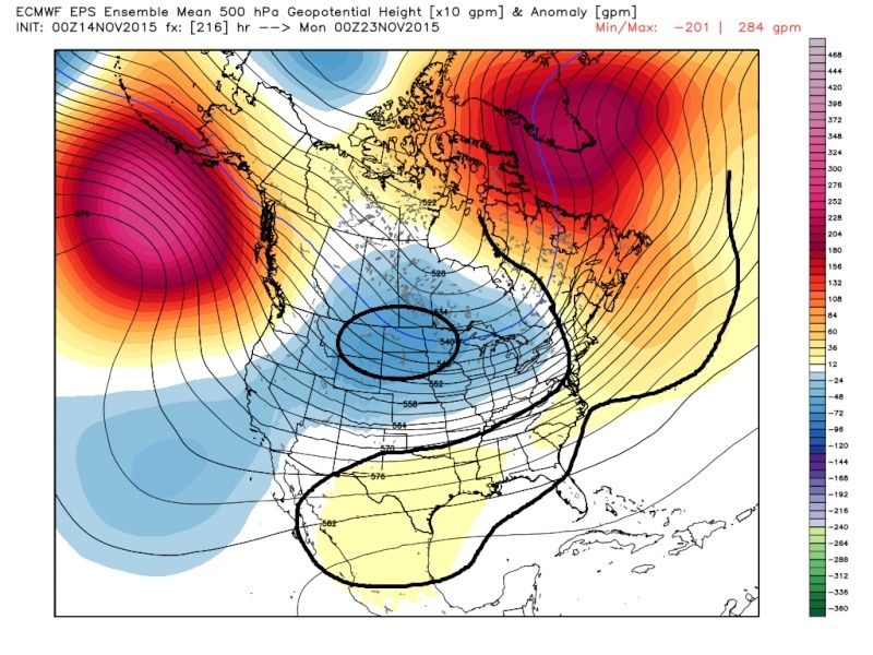
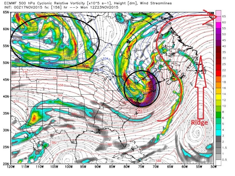
OK so lets revisit my last write up on this time frame, Nov 23-25th, involving the evolution in the models. Previously I posted:
Up until now the SE ridge has flared up with avengence, hence the warmest current Nov relative to avgs on record. However just look at how the EPS model slowly corrects itslf over time. The key to this is the strong positive heights up into the GOA. This will pour arctic air into N America. Remember climatology will still lead to some moderation as it infiltrates the CONUS and bleeds east.
All images are depicting the 00z Nov 23rd time frame compliments of the Euro ensembles. Pay particular attention to how over the last two days the negative heights slowly begin to shift east, and the positive heights along the E coast are slowly beaten back.
Here is the 12z Nov 13th run:

 " />
" />
00z Nov14th run:
 " />
" />
12z Nov 14th:
 " />
" />
And last nights Nov 15th 00z:
 " />
" />
If the -EPO cont to hold strong on modeling I expect the models to cont to correct the center of the trough east, ultimately centering the trough over the GL. This could lead to the potential for a system to develop off the coast between the 23rd and 25th time frame.
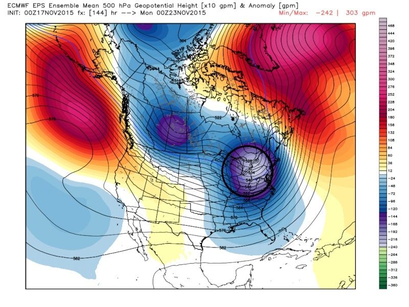
Remember The Euro ens for this same time frame, 00z Nov23rd had this on the 13th:
" />
And has corrected to this on last nights EPS(Euro ensemble mean) 00z run. BANG!
 " />
" />
Remember this is the look of the avg of 51 individual runs combined. This is a pretty strong signal this far out. The Ens now seems to agree to a degree with its operational as Mugs posted above. Lets shift gears and look at the Euro operational.
Before going any further I want to remind everyone that we are still 6days out and there are big key differences between global models, so details are likely to change, but a storm signal, that could affect us, and or lay down some vital snow pack to our north which will be vital for our winter, is possible at this time. ALL Solns are on the table, from little to no impact in the NE to a strong phased system. If a phased system occurs the strongest impacts will most likely be well to the N and W.
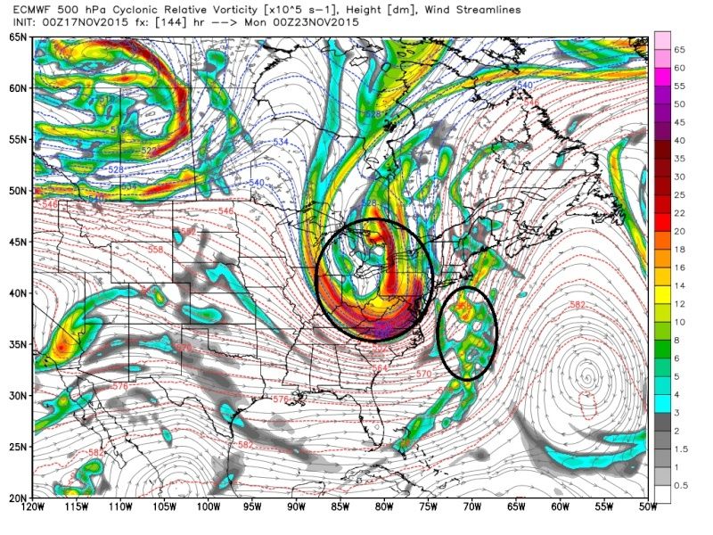
So what Mugs has pointed out in a nut shell, the European is showing a phasing system between energy in the southern branch with energy in the northern branch. Next 3 images are 12z Nov 22nd through 12Z Nov 23rd showing the S and N energy phasing on the Euro:
 " />
" />
 " />
" />
 " />
" />
The result of the upper levels looking like that leads to this on the surface (Same Time stamps only surface maps) Notice the Tropical moisture feed on the last image via warm air conveyor belt(https://www.njstrongweatherforum.com/t517-ccb-banding-cold-air-conveyor-belt)
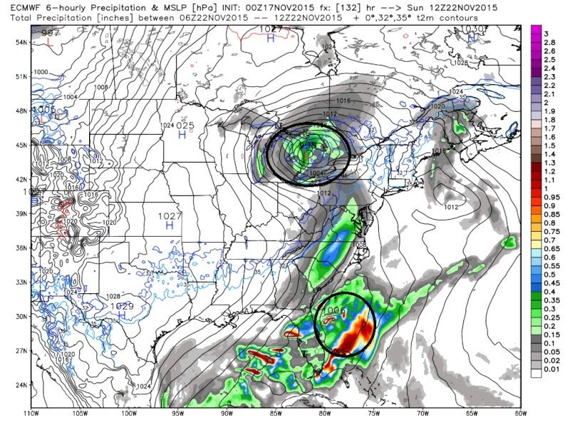 " />
" />
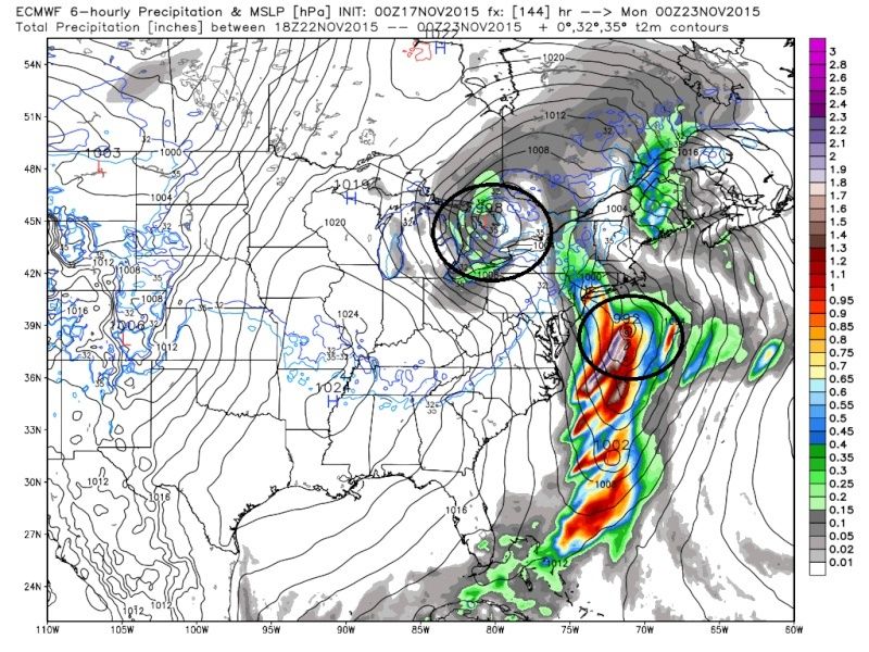 " />
" />
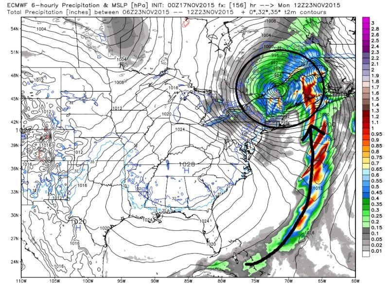 " />
" />
IF this soln happened verbatim a nice base snow pack to our north would happen, and Alex would be thrilled by the outcome:
 " />
" />
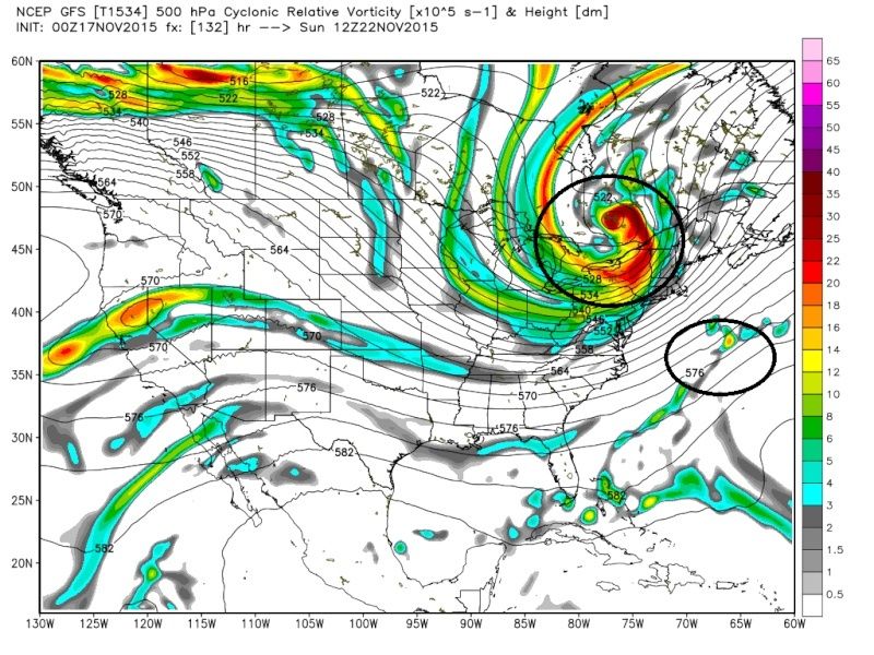
As of now the the GFS and Euro operationals have big differences on how to handle the positioning and strengths of the upper level features. In the image below you can see the GFS is much faster and more progressive with the N and S energies not phasing them until much later if at all. If you compare hr 132 with the Euro you see a huge difference is the GFS has the N energy much weaker, therefore, it does not dig as deep in the CONUS. Notice it is centered more N and over the eastern GL at hr 132; whereas, the Euro at hr 132 has it centered further S and over the Western GL.
" />
 " />
" />
I have not touched on many other key features that will dictate how this plays out (ie: ridging in the EPO region, ridging in the Mid and Northern Atlantic, ridging or lack there of in the Western CONUS, energy in western Canada and its influences) So, if it cont to look intriguing over the next few days we will def make a separate thread for it. For now at least something to watch and maybe to hone the tracking skills for later events that may have more of a direct impact on our area. Can you tell Im itching go regarding winter?
Up until now the SE ridge has flared up with avengence, hence the warmest current Nov relative to avgs on record. However just look at how the EPS model slowly corrects itslf over time. The key to this is the strong positive heights up into the GOA. This will pour arctic air into N America. Remember climatology will still lead to some moderation as it infiltrates the CONUS and bleeds east.
All images are depicting the 00z Nov 23rd time frame compliments of the Euro ensembles. Pay particular attention to how over the last two days the negative heights slowly begin to shift east, and the positive heights along the E coast are slowly beaten back.
Here is the 12z Nov 13th run:
" />00z Nov14th run:
" />12z Nov 14th:
" />And last nights Nov 15th 00z:
" />If the -EPO cont to hold strong on modeling I expect the models to cont to correct the center of the trough east, ultimately centering the trough over the GL. This could lead to the potential for a system to develop off the coast between the 23rd and 25th time frame.
Remember The Euro ens for this same time frame, 00z Nov23rd had this on the 13th:
" />And has corrected to this on last nights EPS(Euro ensemble mean) 00z run. BANG!
" />Remember this is the look of the avg of 51 individual runs combined. This is a pretty strong signal this far out. The Ens now seems to agree to a degree with its operational as Mugs posted above. Lets shift gears and look at the Euro operational.
Before going any further I want to remind everyone that we are still 6days out and there are big key differences between global models, so details are likely to change, but a storm signal, that could affect us, and or lay down some vital snow pack to our north which will be vital for our winter, is possible at this time. ALL Solns are on the table, from little to no impact in the NE to a strong phased system. If a phased system occurs the strongest impacts will most likely be well to the N and W.
So what Mugs has pointed out in a nut shell, the European is showing a phasing system between energy in the southern branch with energy in the northern branch. Next 3 images are 12z Nov 22nd through 12Z Nov 23rd showing the S and N energy phasing on the Euro:
" />" />" />The result of the upper levels looking like that leads to this on the surface (Same Time stamps only surface maps) Notice the Tropical moisture feed on the last image via warm air conveyor belt(https://www.njstrongweatherforum.com/t517-ccb-banding-cold-air-conveyor-belt)
" />" />" />IF this soln happened verbatim a nice base snow pack to our north would happen, and Alex would be thrilled by the outcome:
" />As of now the the GFS and Euro operationals have big differences on how to handle the positioning and strengths of the upper level features. In the image below you can see the GFS is much faster and more progressive with the N and S energies not phasing them until much later if at all. If you compare hr 132 with the Euro you see a huge difference is the GFS has the N energy much weaker, therefore, it does not dig as deep in the CONUS. Notice it is centered more N and over the eastern GL at hr 132; whereas, the Euro at hr 132 has it centered further S and over the Western GL.
" />" />I have not touched on many other key features that will dictate how this plays out (ie: ridging in the EPO region, ridging in the Mid and Northern Atlantic, ridging or lack there of in the Western CONUS, energy in western Canada and its influences) So, if it cont to look intriguing over the next few days we will def make a separate thread for it. For now at least something to watch and maybe to hone the tracking skills for later events that may have more of a direct impact on our area. Can you tell Im itching go regarding winter?
_________________
"In weather and in life, there's no winning and losing; there's only winning and learning."
WINTER 2012/2013 TOTALS 43.65"WINTER 2017/2018 TOTALS 62.85" WINTER 2022/2023 TOTALS 4.9"
WINTER 2013/2014 TOTALS 64.85"WINTER 2018/2019 TOTALS 14.25" WINTER 2023/2024 TOTALS 13.1"
WINTER 2014/2015 TOTALS 71.20"WINTER 2019/2020 TOTALS 6.35"
WINTER 2015/2016 TOTALS 35.00"WINTER 2020/2021 TOTALS 37.75"
WINTER 2016/2017 TOTALS 42.25"WINTER 2021/2022 TOTALS 31.65"
sroc4- Admin
- Posts : 8331
Reputation : 301
Join date : 2013-01-07
Location : Wading River, LI
Re: Long Range Thread 8.0
![]() by Frank_Wx Tue Nov 17, 2015 9:59 am
by Frank_Wx Tue Nov 17, 2015 9:59 am
Nice write up Scott. Here is a closer look at the 00z EURO last night for the Sunday system. This would support accumulating snowfall N&W of NYC. This is rain for the immediate coast.

EDIT: I should say by accumulating snow, I mean well N&W toward central and Upstate NY.
EDIT: I should say by accumulating snow, I mean well N&W toward central and Upstate NY.
_________________
_______________________________________________________________________________________________________
CLICK HERE to view NJ Strong Snowstorm Classifications
Frank_Wx- Godzilla Seeker
- Posts : 21305
Reputation : 328
Join date : 2013-01-05
Age : 31
Location : Jersey City, NJ -
Re: Long Range Thread 8.0
![]() by amugs Tue Nov 17, 2015 10:08 am
by amugs Tue Nov 17, 2015 10:08 am
Great write up - tings are getting interesting and the convection (t-storms)out at the dateline is going to have interesting affects downstream - it is pretty amazing that 10K miles away plus is driving our weather here - people think it what comes from our west (Ohio?) or south (carolinas?). Lest see what the ensembles do over the next few days.
_________________
Mugs
AKA:King: Snow Weenie
Self Proclaimed
WINTER 2014-15 : 55.12" +.02 for 6 coatings (avg. 35")
WINTER 2015-16 Total - 29.8" (Avg 35")
WINTER 2016-17 : 39.5" so far
amugs- Advanced Forecaster - Mod
- Posts : 15093
Reputation : 213
Join date : 2013-01-07
Age : 54
Location : Hillsdale,NJ
Re: Long Range Thread 8.0
![]() by HectorO Tue Nov 17, 2015 11:20 am
by HectorO Tue Nov 17, 2015 11:20 am
If no one has answered yet, what's the weather going to be like on thanksgiving? Given our current trend of cold weekends and warm weekdays, could we be seeing high 60s next week?
-------
https://www.njstrongweatherforum.com/viewtopic.forum?t=593
-------
https://www.njstrongweatherforum.com/viewtopic.forum?t=593

HectorO- Pro Enthusiast

- Posts : 959
Reputation : 27
Join date : 2013-01-11
Page 40 of 40 • 1 ... 21 ... 38, 39, 40
Page 40 of 40
Permissions in this forum:
You cannot reply to topics in this forum|
|
|