
 Search
Blog: February 5th Potential (Sneak Attack?)
Page 1 of 13 • 1, 2, 3 ... 11, 12, 13 ![]()

Blog: February 5th Potential (Sneak Attack?)
![]() by NjWeatherGuy Tue Feb 02, 2016 9:51 pm
by NjWeatherGuy Tue Feb 02, 2016 9:51 pm
http://mp1.met.psu.edu/~fxg1/WRF_0z/wrf54.html
http://mp1.met.psu.edu/~fxg1/SREF21PRSNE_21z/srefloop.html

NjWeatherGuy- Advanced Forecaster

- Posts : 4100
Reputation : 28
Join date : 2013-01-06
Location : Belle Mead, NJ
Re: Blog: February 5th Potential (Sneak Attack?)
![]() by NjWeatherGuy Tue Feb 02, 2016 10:10 pm
by NjWeatherGuy Tue Feb 02, 2016 10:10 pm
http://forums.accuweather.com/index.php?act=attach&type=post&id=280152
NjWeatherGuy- Advanced Forecaster
- Posts : 4100
Reputation : 28
Join date : 2013-01-06
Location : Belle Mead, NJ
Re: Blog: February 5th Potential (Sneak Attack?)
![]() by amugs Tue Feb 02, 2016 10:11 pm
by amugs Tue Feb 02, 2016 10:11 pm
Tom this is like 3 years ago, I am sure Mike will pull it up for us to enjoy. I agree it is coming back and let see what 0 does and beyond. Xmx strayed the trend this afternoon with this and the other storms as well.
I feel we have a lot of tracking to do .
Bring it home Tom!!
Mugs
_________________
Mugs
AKA:King: Snow Weenie
Self Proclaimed
WINTER 2014-15 : 55.12" +.02 for 6 coatings (avg. 35")
WINTER 2015-16 Total - 29.8" (Avg 35")
WINTER 2016-17 : 39.5" so far

amugs- Advanced Forecaster - Mod

- Posts : 15093
Reputation : 213
Join date : 2013-01-07
Age : 54
Location : Hillsdale,NJ
Re: Blog: February 5th Potential (Sneak Attack?)
![]() by NjWeatherGuy Tue Feb 02, 2016 10:17 pm
by NjWeatherGuy Tue Feb 02, 2016 10:17 pm
amugs wrote:Wow,
Tom this is like 3 years ago, I am sure Mike will pull it up for us to enjoy. I agree it is coming back and let see what 0 does and beyond. Xmx strayed the trend this afternoon with this and the other storms as well.
I feel we have a lot of tracking to do .
Bring it home Tom!!
Mugs
I think 2 years ago we had a fropa and a storm modeled like this that came back west. We also had a more west-east tracking versions occur both years 2 years ago and last year I believe where fropas passed and LP formed along the front and gave us a good moderate dump of snow.
NjWeatherGuy- Advanced Forecaster
- Posts : 4100
Reputation : 28
Join date : 2013-01-06
Location : Belle Mead, NJ
Re: Blog: February 5th Potential (Sneak Attack?)
![]() by Math23x7 Tue Feb 02, 2016 10:19 pm
by Math23x7 Tue Feb 02, 2016 10:19 pm
Math23x7- Wx Statistician Guru

- Posts : 2379
Reputation : 68
Join date : 2013-01-08
Re: Blog: February 5th Potential (Sneak Attack?)
![]() by Math23x7 Tue Feb 02, 2016 10:22 pm
by Math23x7 Tue Feb 02, 2016 10:22 pm
Math23x7- Wx Statistician Guru
- Posts : 2379
Reputation : 68
Join date : 2013-01-08
Re: Blog: February 5th Potential (Sneak Attack?)
![]() by NjWeatherGuy Tue Feb 02, 2016 10:23 pm
by NjWeatherGuy Tue Feb 02, 2016 10:23 pm
Math23x7 wrote:Mugs, if this were to pan out, it would remind me of the February 3rd, 2014 snowstorm from the day after Super Bowl 48 at the Meadowlands. I remember Tom was really excited over the potential. The model runs got gradually got closer to the coast with each run and then the night of the Super Bowl, when the score went to 36-0 Seahawks over the Broncos, I took my mind completely off football and toward the storm potential. It was more exciting than the game ever was. =P
Correct
http://weather.gov/media/phi/StormReports/February32014.pdf
NjWeatherGuy- Advanced Forecaster
- Posts : 4100
Reputation : 28
Join date : 2013-01-06
Location : Belle Mead, NJ
Re: Blog: February 5th Potential (Sneak Attack?)
![]() by NjWeatherGuy Tue Feb 02, 2016 10:47 pm
by NjWeatherGuy Tue Feb 02, 2016 10:47 pm
http://www.instantweathermaps.com/GFS-php/showmap-conussfc.php?run=2016020300&time=6&var=PTYPE&hour=057
NjWeatherGuy- Advanced Forecaster
- Posts : 4100
Reputation : 28
Join date : 2013-01-06
Location : Belle Mead, NJ
Re: Blog: February 5th Potential (Sneak Attack?)
![]() by NjWeatherGuy Tue Feb 02, 2016 10:50 pm
by NjWeatherGuy Tue Feb 02, 2016 10:50 pm
NjWeatherGuy- Advanced Forecaster
- Posts : 4100
Reputation : 28
Join date : 2013-01-06
Location : Belle Mead, NJ
Re: Blog: February 5th Potential (Sneak Attack?)
![]() by rb924119 Tue Feb 02, 2016 10:57 pm
by rb924119 Tue Feb 02, 2016 10:57 pm
NjWeatherGuy wrote:Trough axis has trended sharper with 500mb vort today so we'll have to see if these trends can continue.
My issue with this system is that the pattern is still very progressive, and with the second system right on its heels, I don't see it becoming much of an event for anybody except the fish. Also, the fact that this will be a fairly sharp front means that any energy/precipitation will likely become very sheared out very quickly, as winds throughout the atmospheric column are ripping. Lastly, I think it will be very hard to get any precipitation behind the front, as the cold air that is still being advected into our area(s) will work to extensively dry out the lower and mid-levels, essentially making this a pre-frontal precipitation event as whatever energy/precipitation there is works its way along the front as it continues eastward. Just my honest opinion, and I have been wrong PLENTY of times in the past haha
rb924119- Meteorologist

- Posts : 6890
Reputation : 194
Join date : 2013-02-06
Age : 32
Location : Greentown, Pa
Re: Blog: February 5th Potential (Sneak Attack?)
![]() by Frank_Wx Tue Feb 02, 2016 11:02 pm
by Frank_Wx Tue Feb 02, 2016 11:02 pm
_________________
_______________________________________________________________________________________________________
CLICK HERE to view NJ Strong Snowstorm Classifications

Frank_Wx- Godzilla Seeker

- Posts : 21305
Reputation : 328
Join date : 2013-01-05
Age : 31
Location : Jersey City, NJ -

Re: Blog: February 5th Potential (Sneak Attack?)
![]() by NjWeatherGuy Tue Feb 02, 2016 11:28 pm
by NjWeatherGuy Tue Feb 02, 2016 11:28 pm
Frank_Wx wrote:Agree with Ray. Wave 1 is a pretty strung out mess on H5 with a fast flow. Maybe snow showers from Jersey Shore to LI. Snow would fall during the day and surface temps are above freezing so wouldn't amount to anything. But thanks for starting a thread Tom and posting your thoughts. Feels like the good old days
Fair enough, felt it has potential to effect at least part of the reason so probably worthy of a thread at some point anyway. Some of the SREF members are intriguing amping up the system and holding it back a bit allowing a larger precip field to develop and a more consolidated energy. They could just be playing their amplified medium range games but did trend a bit west today.
NjWeatherGuy- Advanced Forecaster
- Posts : 4100
Reputation : 28
Join date : 2013-01-06
Location : Belle Mead, NJ
Re: Blog: February 5th Potential (Sneak Attack?)
![]() by Frank_Wx Tue Feb 02, 2016 11:34 pm
by Frank_Wx Tue Feb 02, 2016 11:34 pm
_________________
_______________________________________________________________________________________________________
CLICK HERE to view NJ Strong Snowstorm Classifications
Frank_Wx- Godzilla Seeker
- Posts : 21305
Reputation : 328
Join date : 2013-01-05
Age : 31
Location : Jersey City, NJ -
Re: Blog: February 5th Potential (Sneak Attack?)
![]() by NjWeatherGuy Wed Feb 03, 2016 4:39 am
by NjWeatherGuy Wed Feb 03, 2016 4:39 am
http://mp1.met.psu.edu/~fxg1/SREF21PRSNE_3z/srefloop.html#picture
6z NAM came a little west too
NjWeatherGuy- Advanced Forecaster
- Posts : 4100
Reputation : 28
Join date : 2013-01-06
Location : Belle Mead, NJ
Re: Blog: February 5th Potential (Sneak Attack?)
![]() by sroc4 Wed Feb 03, 2016 6:36 am
by sroc4 Wed Feb 03, 2016 6:36 am
The result of this progressive flow is weak LP developing along the arctic front that the prev cutter dragged through the area with a track well S and E of the BM. I believe at its best the track will remain SE of the BM but room for improvement def exists. I have not given up on snow for our area esp from NYC and points east esp. Approx 12-13 of the Euro ens individual members have snow into our coverage area. Some only a coating to an inch, afew have as much as 4-8" and a few are in between. We would need to see the ridging to the west trend a tad more amped to phase the jets better which ultimately allows the trough to trend more neutral or less positive which would bring LP closer to the BM and a tad stronger, and possibly bring light snow accum to our area. Points east of NYC have a better shot of this......We will see if trends over the next few days says otherwise.
The ens I had referred to in that write up were from the 00z EPS valid Jan 31st. Shortly after they trended further S and E to look like this: For those who don't know what they are looking at these images represents all 50 euro ens members and their snowfall totals.
Valid 00z Feb 1st:
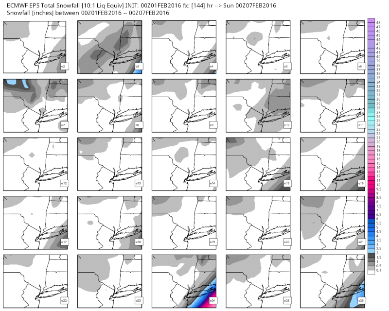
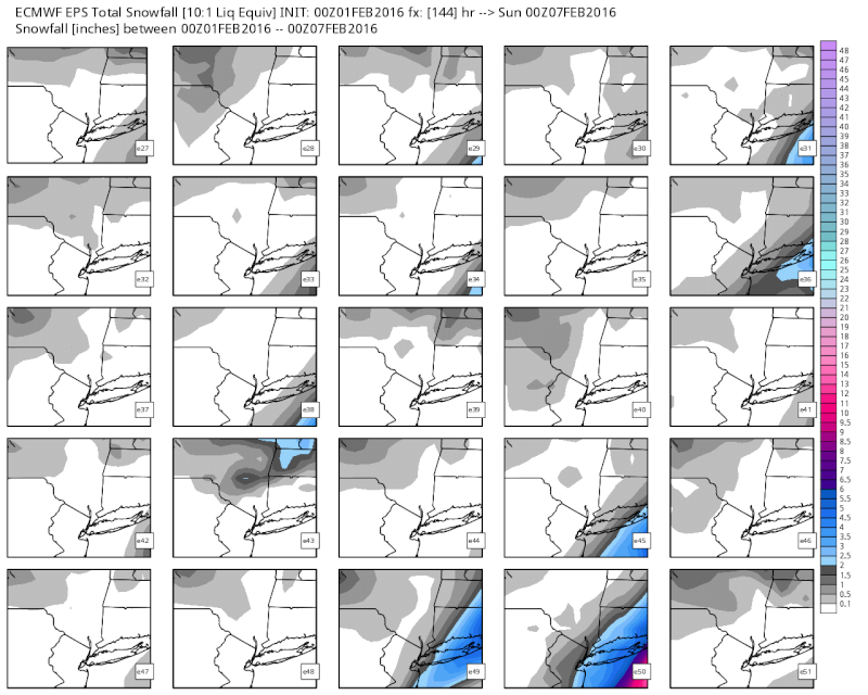 " />
" />To this 00z Feb 2nd:
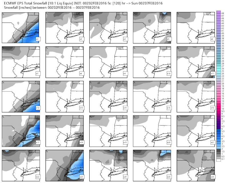
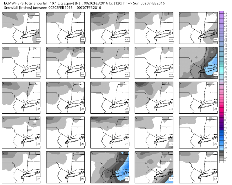
To now this 00Feb 3rd:
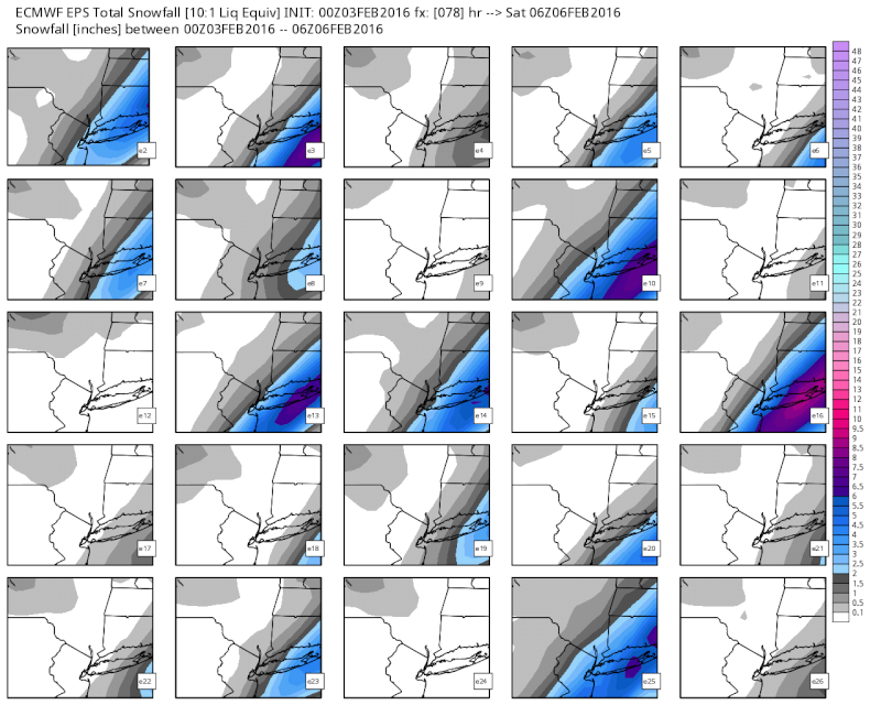
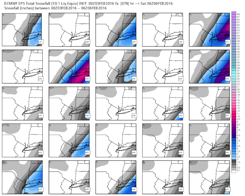
There is a trend. Without a doubt from NYC and points east need to cont to monitor the trends, as this is getting closer and closer to something we can measure, esp for LI and SE CT. A NW trend in the 1-3day has been the trend all season so far. Srefs are starting their trend as well.
Upton agrees as well:
THE FIRST FORECAST CHALLENGE IN THE LONG TERM REVOLVES AROUND LOW
PRESSURE DEVELOPMENT ALONG A STALLED COLD FRONT JUST OFFSHORE
THURSDAY NIGHT. THE FRONT THAT MOVES THROUGH ON THURSDAY WILL STALL
AS IT MOVES OFFSHORE DUE TO ANOMALOUS RIDGING ACROSS THE WESTERN
ATLANTIC.
UPPER TROUGH AXIS WILL BE APPROACHING THURSDAY NIGHT...WITH ENERGY
ROUNDING THE BASE OF THE TROUGH OVER THE SOUTHEAST. THIS TROUGH IS
FORECAST TO TAKE ON A NEGATIVE TILT AS IT APPROACHES. AHEAD OF THE
TROUGH AXIS WILL BE A STRENGTHENING 300 HPA JET STREAK...160 T0 180
KT. THE REGION WILL LIE NEAR THE RIGHT ENTRANCE REGION OF THIS JET
STREAK.
THERE HAS BEEN A TREND OVER THE LAST SEVERAL MODEL CYCLES TO STALL
THE FRONT CLOSER TO THE AREA. AS THE WAVE OF LOW PRESSURE DEVELOPS
ON THE FRONT...PRECIPITATION GETS FORCED NORTHWARD DUE TO THE
ORIENTATION OF THE TROUGH AND THE ENHANCEMENT OF THE UPPER JET.
LATEST CONSENSUS OF THE MODELS AND ENSEMBLES HAS MEASURABLE
PRECIPITATION THURSDAY NIGHT BETWEEN 0.1 AND 0.25 LIQUID
EQUIVALENT...MAINLY FOR CENTRAL AND EASTERN LONG ISLAND AND
SOUTHEAST CONNECTICUT. LOOKING AT MIDDLE AND UPPER LEVEL
FIELDS...THERE DOES APPEAR TO BE SOME ROOM FOR MODELS TO CONTINUE
TRENDING A BIT MORE TO THE NW. WITH ALL OF THIS IN MIND...HAVE
INCREASED POPS ACROSS LONG ISLAND AND CONNECTICUT. HAVE ELECTED TO
CAP THEM AT CHANCE FOR NOW...BUT IF THE MODELS AND ENSEMBLES
CONTINUE TO TREND AS THEY HAVE OVER THE LAST SEVERAL CYCLES...THEN
POPS WOULD NEED TO BE RAISED FURTHER AND POSSIBLY EXPANDED WESTWARD.
IT IS ALSO WORTH NOTING THAT THE LATEST 03Z SREF HAS SEVERAL MEMBERS
WITH AROUND AN INCH OF SNOW AS FAR WEST AS THE NYC METRO. THE TREND
ON THE LAST SEVERAL SREF MEANS HAS BEEN FOR SMALL SHIFTS WESTWARD
WITH THE PRECIP...AND SMALL SHIFTS UPWARD FOR MEAN SNOW ACCUM.
THERMAL PROFILES SHOULD BE SUPPORTIVE OF SNOW THURSDAY
NIGHT...ESPECIALLY AFTER MIDNIGHT. LIGHT SNOW ACCUMULATION IS
POSSIBLE ACROSS PARTS OF LONG ISLAND AND SOUTH EAST CT TOWARDS
DAYBREAK FRIDAY. THERE IS POTENTIAL FOR ADVISORY LEVEL AMOUNTS HERE.
IF MODEL TRENDS CONTINUE...THEN SOME LIGHT ACCUMULATING SNOW WOULD
BE POSSIBLE FURTHER WEST.
Last edited by sroc4 on Wed Feb 03, 2016 7:02 am; edited 1 time in total
_________________
"In weather and in life, there's no winning and losing; there's only winning and learning."
WINTER 2012/2013 TOTALS 43.65"WINTER 2017/2018 TOTALS 62.85" WINTER 2022/2023 TOTALS 4.9"
WINTER 2013/2014 TOTALS 64.85"WINTER 2018/2019 TOTALS 14.25" WINTER 2023/2024 TOTALS 13.1"
WINTER 2014/2015 TOTALS 71.20"WINTER 2019/2020 TOTALS 6.35"
WINTER 2015/2016 TOTALS 35.00"WINTER 2020/2021 TOTALS 37.75"
WINTER 2016/2017 TOTALS 42.25"WINTER 2021/2022 TOTALS 31.65"

sroc4- Admin
- Posts : 8331
Reputation : 301
Join date : 2013-01-07
Location : Wading River, LI
Re: Blog: February 5th Potential (Sneak Attack?)
![]() by NjWeatherGuy Wed Feb 03, 2016 6:55 am
by NjWeatherGuy Wed Feb 03, 2016 6:55 am
NjWeatherGuy- Advanced Forecaster
- Posts : 4100
Reputation : 28
Join date : 2013-01-06
Location : Belle Mead, NJ
Re: Blog: February 5th Potential (Sneak Attack?)
![]() by sroc4 Wed Feb 03, 2016 7:05 am
by sroc4 Wed Feb 03, 2016 7:05 am

_________________
"In weather and in life, there's no winning and losing; there's only winning and learning."
WINTER 2012/2013 TOTALS 43.65"WINTER 2017/2018 TOTALS 62.85" WINTER 2022/2023 TOTALS 4.9"
WINTER 2013/2014 TOTALS 64.85"WINTER 2018/2019 TOTALS 14.25" WINTER 2023/2024 TOTALS 13.1"
WINTER 2014/2015 TOTALS 71.20"WINTER 2019/2020 TOTALS 6.35"
WINTER 2015/2016 TOTALS 35.00"WINTER 2020/2021 TOTALS 37.75"
WINTER 2016/2017 TOTALS 42.25"WINTER 2021/2022 TOTALS 31.65"
sroc4- Admin
- Posts : 8331
Reputation : 301
Join date : 2013-01-07
Location : Wading River, LI
Re: Blog: February 5th Potential (Sneak Attack?)
![]() by sroc4 Wed Feb 03, 2016 7:08 am
by sroc4 Wed Feb 03, 2016 7:08 am


_________________
"In weather and in life, there's no winning and losing; there's only winning and learning."
WINTER 2012/2013 TOTALS 43.65"WINTER 2017/2018 TOTALS 62.85" WINTER 2022/2023 TOTALS 4.9"
WINTER 2013/2014 TOTALS 64.85"WINTER 2018/2019 TOTALS 14.25" WINTER 2023/2024 TOTALS 13.1"
WINTER 2014/2015 TOTALS 71.20"WINTER 2019/2020 TOTALS 6.35"
WINTER 2015/2016 TOTALS 35.00"WINTER 2020/2021 TOTALS 37.75"
WINTER 2016/2017 TOTALS 42.25"WINTER 2021/2022 TOTALS 31.65"
sroc4- Admin
- Posts : 8331
Reputation : 301
Join date : 2013-01-07
Location : Wading River, LI
Re: Blog: February 5th Potential (Sneak Attack?)
![]() by NjWeatherGuy Wed Feb 03, 2016 7:57 am
by NjWeatherGuy Wed Feb 03, 2016 7:57 am
sroc4 wrote:Latest 4km NAM: Its really close: Trend is our friend:
Exactly my point, if its trending (certainly seems that way), we could see a minor-moderate event along the I-95 corridor.
NjWeatherGuy- Advanced Forecaster
- Posts : 4100
Reputation : 28
Join date : 2013-01-06
Location : Belle Mead, NJ
Re: Blog: February 5th Potential (Sneak Attack?)
![]() by NjWeatherGuy Wed Feb 03, 2016 7:59 am
by NjWeatherGuy Wed Feb 03, 2016 7:59 am
NjWeatherGuy- Advanced Forecaster
- Posts : 4100
Reputation : 28
Join date : 2013-01-06
Location : Belle Mead, NJ
Re: Blog: February 5th Potential (Sneak Attack?)
![]() by sroc4 Wed Feb 03, 2016 8:15 am
by sroc4 Wed Feb 03, 2016 8:15 am
NjWeatherGuy wrote:Of course immediate coast has greatest chance for accumulation atm. But temp profiles are marginal, if the storm comes further west and is more robust, it would yield a better solution for all.
Agreed. The more the precip makes it in the better chance for wet bulbing during the precip. Again its all marginal at this time, and Im not confident just yet on accumulations, but there def is a trend. "Weather" it trends back the other way over the next 36hrs we shall see, but the NW trend in the SR seems to be the general theme so far this season.
_________________
"In weather and in life, there's no winning and losing; there's only winning and learning."
WINTER 2012/2013 TOTALS 43.65"WINTER 2017/2018 TOTALS 62.85" WINTER 2022/2023 TOTALS 4.9"
WINTER 2013/2014 TOTALS 64.85"WINTER 2018/2019 TOTALS 14.25" WINTER 2023/2024 TOTALS 13.1"
WINTER 2014/2015 TOTALS 71.20"WINTER 2019/2020 TOTALS 6.35"
WINTER 2015/2016 TOTALS 35.00"WINTER 2020/2021 TOTALS 37.75"
WINTER 2016/2017 TOTALS 42.25"WINTER 2021/2022 TOTALS 31.65"
sroc4- Admin
- Posts : 8331
Reputation : 301
Join date : 2013-01-07
Location : Wading River, LI
Re: Blog: February 5th Potential (Sneak Attack?)
![]() by NjWeatherGuy Wed Feb 03, 2016 8:56 am
by NjWeatherGuy Wed Feb 03, 2016 8:56 am
sroc4 wrote:NjWeatherGuy wrote:Of course immediate coast has greatest chance for accumulation atm. But temp profiles are marginal, if the storm comes further west and is more robust, it would yield a better solution for all.
Agreed. The more the precip makes it in the better chance for wet bulbing during the precip. Again its all marginal at this time, and Im not confident just yet on accumulations, but there def is a trend. "Weather" it trends back the other way over the next 36hrs we shall see, but the NW trend in the SR seems to be the general theme so far this season.
Thats why this potential still interests me, even the past near miss shifted hundreds of miles west in the last 36-48 hours and was just offshore, was modeled to swing way out to sea and interaction led to the snow showers we got from the northern stream vort. If this stays with the theme of the season it should come back west but all storms are different so its never a good idea to speak in definites. Just think the potential is still there.
NjWeatherGuy- Advanced Forecaster
- Posts : 4100
Reputation : 28
Join date : 2013-01-06
Location : Belle Mead, NJ
Re: Blog: February 5th Potential (Sneak Attack?)
![]() by Math23x7 Wed Feb 03, 2016 10:01 am
by Math23x7 Wed Feb 03, 2016 10:01 am
Math23x7- Wx Statistician Guru
- Posts : 2379
Reputation : 68
Join date : 2013-01-08
Re: Blog: February 5th Potential (Sneak Attack?)
![]() by NjWeatherGuy Wed Feb 03, 2016 10:08 am
by NjWeatherGuy Wed Feb 03, 2016 10:08 am
http://mp1.met.psu.edu/~fxg1/WRF_12z/wrf48.html
NjWeatherGuy- Advanced Forecaster
- Posts : 4100
Reputation : 28
Join date : 2013-01-06
Location : Belle Mead, NJ
Re: Blog: February 5th Potential (Sneak Attack?)
![]() by amugs Wed Feb 03, 2016 10:19 am
by amugs Wed Feb 03, 2016 10:19 am
BRING ON HERE HOME MAN - AWESOME JOB - YOU ARE LOCKED IN WITH THIS ONE!!
SREFS!!!! TICKING NW!! NYC, LI AND COASTAL NJ SO FAR


_________________
Mugs
AKA:King: Snow Weenie
Self Proclaimed
WINTER 2014-15 : 55.12" +.02 for 6 coatings (avg. 35")
WINTER 2015-16 Total - 29.8" (Avg 35")
WINTER 2016-17 : 39.5" so far
amugs- Advanced Forecaster - Mod
- Posts : 15093
Reputation : 213
Join date : 2013-01-07
Age : 54
Location : Hillsdale,NJ
Page 1 of 13 • 1, 2, 3 ... 11, 12, 13 ![]()
|
|
|